
Thank you to all our volunteers who reported during this rain event!
| Station ID | Name |
3 day total
|
| IN-PT-64 | VALPARAISO 1.4 ENE |
11.02
|
| IN-PT-32 | PORTAGE 0.9 ESE |
10.74
|
| IN-PT-69 | PORTER 0.6 S |
10.69
|
| IN-PT-34 | CHESTERTON 1.7 WSW |
10.59
|
| IL-DP-53 | WHEATON 1.7 N |
10.53
|
| ELBI2 | ELBURN |
10.51
|
| IL-KN-30 | ELBURN 0.4 NW |
10.51
|
| IN-PT-60 | LAKES OF THE FOUR SEASONS |
10.41
|
| IN-PT-8 | VALPARAISO 0.6 SE |
10.33
|
| IL-CK-107 | EVANSTON 1.4 N |
10.20
|
| IN-PT-27 | KOUTS 2.8 N |
10.16
|
| IN-PT-62 | VALPARAISO 7.4 WSW |
10.09
|
| IL-CK-69 | PARK FOREST 0.8 NNE |
10.01
|
| IN-LK-6 | CROWN POINT 6.6 ESE |
9.94
|
| IN-PT-1 | VALPARAISO 3.9 NNW |
9.87
|
| IN-LP-14 | MICHIGAN CITY 1.3 SSW |
9.79
|
| IL-CK-84 | BARTLETT 1.2 NE |
9.78
|
| IN-PT-13 | VALPARAISO 6.2 WSW |
9.74
|
| IN-PT-30 | VALPARAISO 5.8 WSW |
9.67
|
| IN-LK-31 | MERRILLVILLE 0.8 NNW |
9.37
|
| IL-CK-46 | DES PLAINES 0.5 NW |
9.36
|
| IN-PT-19 | VALPARAISO 5.9 NW |
9.22
|
| SCKI2 | ST CHARLES 7 NW |
9.18
|
| PAWI2 | PAW PAW |
9.16
|
| IL-KN-8 | GENEVA 3.3 WSW |
9.15
|
| IL-KN-58 | LILY LAKE 2.1 E |
9.13
|
| IN-PT-43 | CHESTERTON 2.3 ESE |
9.13
|
| SCHI2 | ST CHARLES |
9.10
|
| IL-KN-68 | GENEVA 0.9 N |
9.09
|
| IN-PT-12 | VALPARAISO 4.3 SW |
9.09
|
| IL-KN-64 | ST CHARLES 0.1 E |
9.08
|
| IN-LK-26 | CROWN POINT 1.1 N |
9.04
|
| IL-KN-66 | GENEVA 1.0 E |
9.03
|
| IL-DP-34 | WEST CHICAGO 2.7 N |
9.02
|
| IL-CK-75 | ELK GROVE VILLAGE 2.2 WSW |
8.95
|
| IN-LK-8 | HAMMOND 3.0 SW |
8.95
|
| IN-PT-44 | CROWN POINT 7.6 ESE |
8.90
|
| IL-CK-64 | HOMEWOOD 0.1 ESE |
8.89
|
| IL-KN-31 | ST CHARLES 1.6 SW |
8.83
|
| IN-PT-14 | CHESTERTON 3.0 ESE |
8.77
|
| IL-CK-76 | FLOSSMOOR 1.1 ESE |
8.76
|
| IN-PT-25 | VALPARAISO 5.1 WSW |
8.76
|
| IL-CK-63 | ELK GROVE VILLAGE 0.6 ESE |
8.74
|
| IL-DP-61 | ROSELLE 0.5 S |
8.61
|
| STAI2 | STREATOR |
8.55
|
| IL-WL-25 | CRETE 2.6 E |
8.55
|
| IN-LK-24 | CROWN POINT 2.0 WSW |
8.55
|
| IL-KN-63 | GENEVA 1.7 WSW |
8.54
|
| IL-KN-1 | GENEVA 1.6 ENE |
8.52
|
| IL-DP-42 | CAROL STREAM 0.3 SSE |
8.51
|
| IL-CK-18 | SKOKIE 1.0 NNE |
8.47
|
| IL-DP-11 | CAROL STREAM 0.7 WNW |
8.45
|
| ORD | CHICAGO OHARE AIRPORT |
8.45
|
| IN-PT-18 | HEBRON 3.7 NE |
8.31
|
| IL-KN-33 | NORTH AURORA 1.5 NE |
8.27
|
| IL-KN-10 | ELGIN 0.9 WSW |
8.26
|
| IL-KN-23 | BATAVIA 1.5 WNW |
8.23
|
| IL-KN-57 | GENEVA 1.9 W |
8.21
|
| IN-LP-31 | LA CROSSE 0.4 E |
8.20
|
| IL-WL-18 | CRETE 1.4 SW |
8.13
|
| IL-KN-62 | BATAVIA 1.3 WNW |
8.11
|
| IL-CK-27 | STREAMWOOD 1.1 NNE |
8.01
|
| IL-CK-94 | LINCOLNWOOD 1.8 E |
7.85
|
| IL-DP-69 | GLEN ELLYN 1.0 NE |
7.84
|
| PEOI2 | PEOTONE |
7.83
|
| IL-DP-60 | GLEN ELLYN 0.8 NW |
7.72
|
| IL-DP-58 | WHEATON 0.5 W |
7.72
|
| IL-WL-23 | BEECHER 3.4 SSE |
7.71
|
| CBGI2 | BOTANIC GARDENS |
7.62
|
| IL-DP-71 | ADDISON 1.6 WNW |
7.62
|
| IN-LK-28 | WHITING 0.5 W |
7.61
|
| BATI2 | BATAVIA |
7.60
|
| IL-KN-4 | SUGAR GROVE 0.7 NE |
7.49
|
| CTYI2 | COAL CITY 4NNW |
7.45
|
| IL-WL-42 | MOKENA 1.3 W |
7.45
|
| IL-GY-1 | CARBON HILL 3.1 N |
7.45
|
| IL-KN-9 | ELGIN 1.0 S |
7.44
|
| IN-JS-36 | DE MOTTE 1.3 SW |
7.43
|
| PKFI2 | PARK FOREST |
7.40
|
| IL-CK-51 | ORLAND HILLS 0.6 S |
7.39
|
| IL-CK-82 | BURNHAM-HEGEWISCH 1.6 NNW |
7.37
|
| LLLI3 | LOWELL |
7.35
|
| IL-DP-45 | WHEATON 1.8 SSW |
7.34
|
| IL-KN-51 | SUGAR GROVE 1.4 ENE |
7.24
|
| IL-DP-38 | ELMHURST 0.4 SW |
7.22
|
| IL-KN-12 | BATAVIA 0.9 W |
7.13
|
| PRUI2 | PERU |
7.11
|
| ELGI2 | ELGIN |
7.08
|
| IL-DP-29 | GLEN ELLYN 1.6 SSE |
7.08
|
| IL-CK-53 | GLENCOE 0.1 NW |
7.06
|
| IL-DK-5 | CORTLAND 0.3 SSW |
7.00
|
| LVGI3 | LAKE VILLAGE |
6.99
|
| IL-KN-39 | AURORA 3.4 W |
6.94
|
| IL-LS-11 | MENDOTA 0.9 N |
6.89
|
| IN-LK-25 | MUNSTER 0.8 SSE |
6.86
|
| IL-KK-7 | KANKAKEE 4.5 WNW |
6.78
|
| SAAI2 | ST ANNE |
6.70
|
| HRSI2 | HERSCHER |
6.69
|
| IL-CK-117 | CHICAGO 3.0 NW |
6.68
|
| IL-CK-41 | HOFFMAN ESTATES 2.1 SE |
6.66
|
| IL-WL-27 | PLAINFIELD 4.0 NNW |
6.62
|
| IL-LV-5 | CORNELL 5.4 NNE |
6.59
|
| IL-CK-14 | CHICAGO 5.5 ESE |
6.59
|
| MDWI2 | MIDWAY 3SW |
6.58
|
| LNNI2 | LA GRANGE |
6.58
|
| IL-CK-62 | STICKNEY 1.2 W |
6.56
|
| IL-DP-32 | LISLE 1.3 SE |
6.50
|
| DWNI2 | DOWNERS GROVE |
6.49
|
| IL-DP-25 | DOWNERS GROVE 0.7 S |
6.49
|
| IL-DP-24 | LISLE 0.6 W |
6.49
|
| IL-KD-24 | OSWEGO 5.0 SSE |
6.48
|
| IL-CK-50 | PALOS PARK 1.3 SW |
6.47
|
| IL-CK-98 | LA GRANGE PARK 0.7 SSW |
6.46
|
| IL-DP-30 | LISLE 0.5 WSW |
6.45
|
| PMJI2 | JOLIET |
6.44
|
| IL-DP-20 | NAPERVILLE 3.2 ESE |
6.44
|
| BARI2 | BARRINGTON |
6.39
|
| IL-WL-36 | HOMER GLEN 3.9 WNW |
6.35
|
| IL-DP-14 | WESTMONT 1.2 SSE |
6.34
|
| MUNI2 | MUNDELEIN |
6.31
|
| IL-KD-5 | MONTGOMERY 0.8 SSE |
6.28
|
| IL-DP-16 | AURORA 3.6 SE |
6.26
|
| IL-KD-25 | YORKVILLE 1.8 SSE |
6.24
|
| IL-WL-44 | NAPERVILLE 3.6 SSW |
6.22
|
| IL-LK-19 | WAUKEGAN 2.2 N |
6.22
|
| IL-LK-15 | BANNOCKBURN 0.5 ESE |
6.20
|
| IL-DK-6 | DE KALB 0.3 ENE |
6.19
|
| IL-CK-74 | OAK PARK 1.3 NNE |
6.19
|
| IN-JS-11 | WHEATFIELD 1.8 ENE |
6.16
|
| IL-DP-18 | DOWNERS GROVE 2.1 SE |
6.15
|
| IL-DP-22 | LISLE 1.3 NE |
6.12
|
| IL-LE-8 | ASHTON 0.4 SSW |
6.11
|
| IL-KD-23 | MONTGOMERY 1.7 SSE |
6.07
|
| IN-NW-3 | KENTLAND 0.3 ENE |
6.06
|
| JKJI2 | JOLIET 2N |
6.05
|
| SNWI2 | STREAMWOOD |
6.04
|
| RCHI2 | ROCHELLE |
6.03
|
| IL-LS-5 | SENECA 1.5 SSW |
6.00
|
| IN-JS-31 | DE MOTTE 5.9 S |
6.00
|
| PFDI2 | PLAINFIELD |
5.99
|
| MHYI2 | MCHENRY |
5.97
|
| IL-DK-2 | DE KALB 0.8 SSW |
5.97
|
| IN-NW-1 | MOUNT AYER 1.6 NNE |
5.96
|
| DEKI2 | DE KALB |
5.91
|
| IL-KN-42 | CARPENTERSVILLE 1.3 ESE |
5.88
|
| IL-LS-19 | SANDWICH 2.0 SSW |
5.88
|
| IL-KD-12 | YORKVILLE 1.1 W |
5.87
|
| IL-DK-1 | DE KALB 1.4 W |
5.85
|
| IN-JS-9 | RENSSELAER 5.3 WNW |
5.85
|
| IN-NW-6 | KENTLAND 1.7 SSE |
5.85
|
| IL-CK-88 | COUNTRYSIDE 0.8 ENE |
5.84
|
| MORI3 | MOROCCO |
5.82
|
| LKZI2 | LAKE ZURICH |
5.82
|
| IL-CK-61 | OAK PARK 1.0 SW |
5.81
|
| IL-LK-11 | LINCOLNSHIRE 0.9 N |
5.80
|
| IL-LV-6 | PONTIAC 1.0 SE |
5.77
|
| IL-CK-95 | COUNTRYSIDE 1.3 NNE |
5.76
|
| WODI2 | WOODSTOCK 5NW |
5.68
|
| IL-LK-16 | BUFFALO GROVE 1.5 N |
5.68
|
| YOIK2 | YORKVILLE 2SE |
5.67
|
| IL-LE-7 | NELSON 1.6 E |
5.67
|
| IL-LS-7 | SHERIDAN 3.4 SSE |
5.67
|
| IL-KD-26 | YORKVILLE 0.7 NE |
5.65
|
| IL-LV-4 | CHENOA 3.9 NNW |
5.64
|
| IN-JS-1 | WHEATFIELD 2.8 S |
5.58
|
| IL-CK-32 | CHICAGO 6.4 NNE |
5.57
|
| IL-KD-9 | LISBON 4.4 NE |
5.55
|
| IL-CK-122 | CHICAGO 6.65 NE |
5.52
|
| IL-DK-4 | GENOA 1.7 N |
5.50
|
| OKKI2 | OAK BROOK |
5.46
|
| IL-MCH-24 | HUNTLEY 4.3 W |
5.44
|
| IL-DK-9 | DE KALB 3.2 WNW |
5.43
|
| MDTI2 | MENDOTA |
5.40
|
| IL-FD-3 | PIPER CITY 0.2 ESE |
5.32
|
| IL-WL-16 | HOMER GLEN 0.8 ENE |
5.31
|
| IL-MCH-16 | CARY 1.9 NE |
5.22
|
| FRBI2 | FAIRBURY |
5.20
|
| IL-LK-28 | ROUND LAKE 2.0 S |
5.18
|
| CHTI2 | CHATSWORTH |
5.17
|
| IL-LV-7 | CHATSWORTH 0.4 ESE |
5.17
|
| IL-LK-27 | LIBERTYVILLE 0.8 SSW |
5.17
|
| IL-LS-12 | PERU 0.6 SW |
5.03
|
| PIPI2 | PIPER CITY |
5.03
|
| IL-CK-97 | CHICAGO 6.8 NNE |
4.94
|
| PXNI2 | PAXTON |
4.94
|
| IL-LK-8 | GURNEE 2.5 NE |
4.67
|
| IL-MCH-13 | BULL VALLEY 2.5 WNW |
4.64
|
| IL-LE-5 | STERLING 4.3 NE |
4.52
|
| IL-LK-3 | BEACH PARK 1.4 W |
4.49
|
| IL-LE-10 | DIXON 3.0 NNW |
4.47
|
| IL-LS-1 | OTTAWA 1.3 NW |
4.37
|
| IL-LS-17 | OTTAWA 1.6 N |
4.35
|
| OTTI2 | OTTAWA |
4.27
|
| IL-OG-3 | POLO 0.4 WSW |
3.93
|
| IL-LK-9 | LAKE VILLA 1.1 SSW |
3.88
|
| IL-MCH-30 | WONDER LAKE 0.8 WNW |
3.82
|
| IL-WN-10 | NEW MILFORD 3.3 W |
3.75
|
| IL-LK-35 | WINTHROP HARBOR 0.4 N |
3.73
|
| IN-JS-23 | REMINGTON 0.3 SSE |
3.71
|
| SGVI2 | SPRING GROVE 2N |
3.60
|
| RMGI3 | REMINGTON |
3.56
|
| RFD | CHICAGO ROCKFORD INTL AIRPORT |
3.07
|
| ROFI2 | ROCKFORD 4NW |
2.85
|
| IL-WN-8 | ROCKFORD 0.7 NW |
2.69
|
| IL-BN-4 | POPLAR GROVE 3.2 SW |
2.59
|
| RSCI2 | ROSCOE 2 SE |
2.55
|
| IL-WN-19 | ROCKTON 1.0 ESE |
2.55
|
| IL-WN-2 | ROSCOE 1.6 ESE |
2.55
|
| IL-WN-6 | SOUTH BELOIT 1.9 SE |
2.54
|
| IL-WN-3 | MACHESNEY PARK 3.1 ENE |
2.48
|
| HVDI2 | HARVARD |
2.44
|
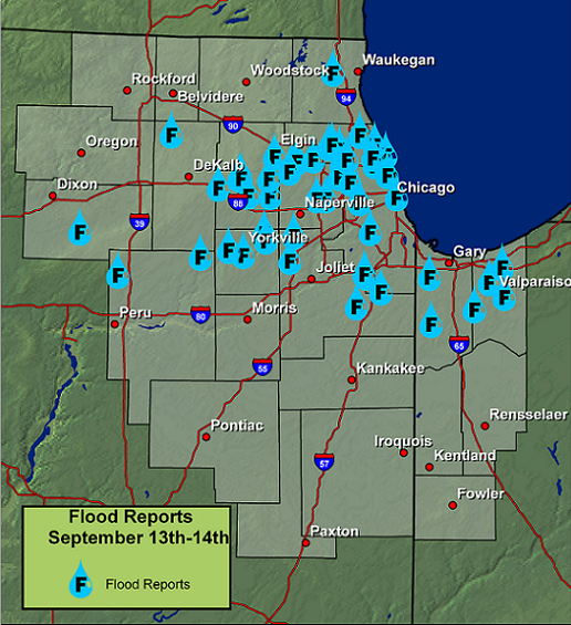
A tropical air mass set up across northern Illinois and northwest Indiana which led to a large portion of the region ending up with substantial flooding. The heaviest rain began early on Saturday the 13th and lasted through most of the day, with a brief period in the evening where rain finally ceased. Rainfall amounts were generally in the 4 to 8 inch range across the hardest hit areas, which spans across most of northeast Illinois and northwest Indiana. Numerous streets and highways have shut down because of the heavy rain along with basement flooding. The large swath of heavy rain has also caused most rivers in the region to climb into flood stage, with major to record flooding forecast on some rivers. Additionally, the 6.64 inches of rain that fell at O’Hare International Airport on the 13th established a new all time record calendar day rainfall for Chicago at that time, where records date back to 1871. (This record was surpassed in 2011) The following is a map plotting out all of the Flood or Flash Flood reports received by the National Weather Service in Romeoville from Saturday morning through Saturday evening as well as the radar estimate of the event from Friday evening (when rainfall was light) through Sunday morning.
For flooding photos from this event, see here.
Record River Crests for Select Locations in northeast Illinois and northwest Indiana
The following is a list of record crest data for select river locations that were set during this event. Note these sites may have reached higher stages after this event. To get more information on each data point, go to our Advanced Hydrologic Prediction Service (AHPS) webpage.
| Location | Flood Stage | Crest (ft) | Remarks | ||
| LITTLE CALUMET RIVER | |||||
| Munster | 12 | 17.31 9/14/2008 | |||
| South Holland | 16.5 | 20.50 11/28/1990 | |||
| DES PLAINES RIVER | |||||
| Des Plaines | 5 | 10.88 10/1/1986 | |||
| Riverside | 7 | 9.90 8/15/1987 | |||
| FOX RIVER | |||||
| Dayton | 12 | 36.47 1/25/1960 | |||
| ILLINOIS RIVER | |||||
| Morris | 16 | 24.84 9/16/2008 | |||
| LaSalle | 20 |
33.79 9/16/2008 |
|||
| KANKAKEE RIVER | |||||
| Shelby | 9 | 12.98 3/24/1982 |
|
||
| Momence | 5 | 10.51 3/6/1979 | |||
| Wilmington | 6.5 | 13.88 1/30/1968 | |||
| VERMILION RIVER | |||||
| Leonore | 16 | 27.13 12/4/1982 | |||
The result of the heavy rain was widespread flooding of roads, creeks, drainage areas, open fields, low lying areas and basements. Small streams such as the North Branch of the Chicago River, Salt Creek, the DuPage River, the Little Calumet River and its tributaries rapidly rose to record or near record levels. These small streams fed larger rivers including the Des Plaines, Fox, Kankakee, and Illinois Rivers. The Des Plaines reached the second highest crest on record at Des Plaines and Riverside, while the Illinois set records at Morris and LaSalle.

Flooding in downtown Des Plaines. Photo courtesy of CLTV.

Flooding at OHare International Airport
Despite two significant tornado outbreaks, on January 7 and June 7, and an intense wind and tornado event on August 4, the flooding of mid September was by far the biggest weather event in the Chicago area for 2008. This event impacted more people and resulted in more damage and fatalities than any event in this area in the last several years. Total estimated damages from the flooding are around 100 million dollars. There were four flood related fatalities, making this the most deadly storm-related weather event in northern Illinois and northwest Indiana since eight people were killed by a tornado in Utica in April, 2004.

Flooding on the Illinois River at Peru
Historically, about half of all flood fatalities occur in vehicles, when people drive into flooded roads, or get swept off a road by fast moving water. While there were several incidents where people in vehicles were swept away by flood water and had to be rescued, none of the four fatalities in the September flooding occurred in vehicles. Hundreds of cars were also stranded in deep standing water, fortunately with no loss of life. Here is a review of the four fatalities;
Our sympathies go out to the families.
Lessons Learned

Record flooding along the Illinois River at Morris. Photo by Don Lyon.
Finally, the National Weather Service would like to thank everyone involved in the flood event.

