Chicago, IL
Weather Forecast Office
Overview
On Tuesday, March 3rd, 2020, the NWS Weather Forecast Office in Chicago, Illinois changed Public Forecast Zones encompassing Cook and Will Counties in northeast Illinois. These changes were coordinated with partnering agencies and will improve forecast services for the city of Chicago and portions of the Chicago metropolitan area by allowing for more refined watches, warnings and advisories.
The official Service Change Notice issued Tuesday, December 17th, 2019 outlines the changes and can be found at:
www.weather.gov/media/notification/scn19-109lot_zone-changes.pdf
Why are these changes being made?
Cook County and Will County each provide challenges to the forecast warning process due to a combination of their unique shape, large size and proximity to Lake Michigan. This can often result in over-warning a significant population when only a portion of each county may actually experience an expected hazard. This change will allow National Weather Service forecasters to issue watches, warnings and advisories for individual portions of Cook County or Will County, when warranted. For more information on each county and what changes will occur, see the individual tabs above.
What are Forecast Zones?
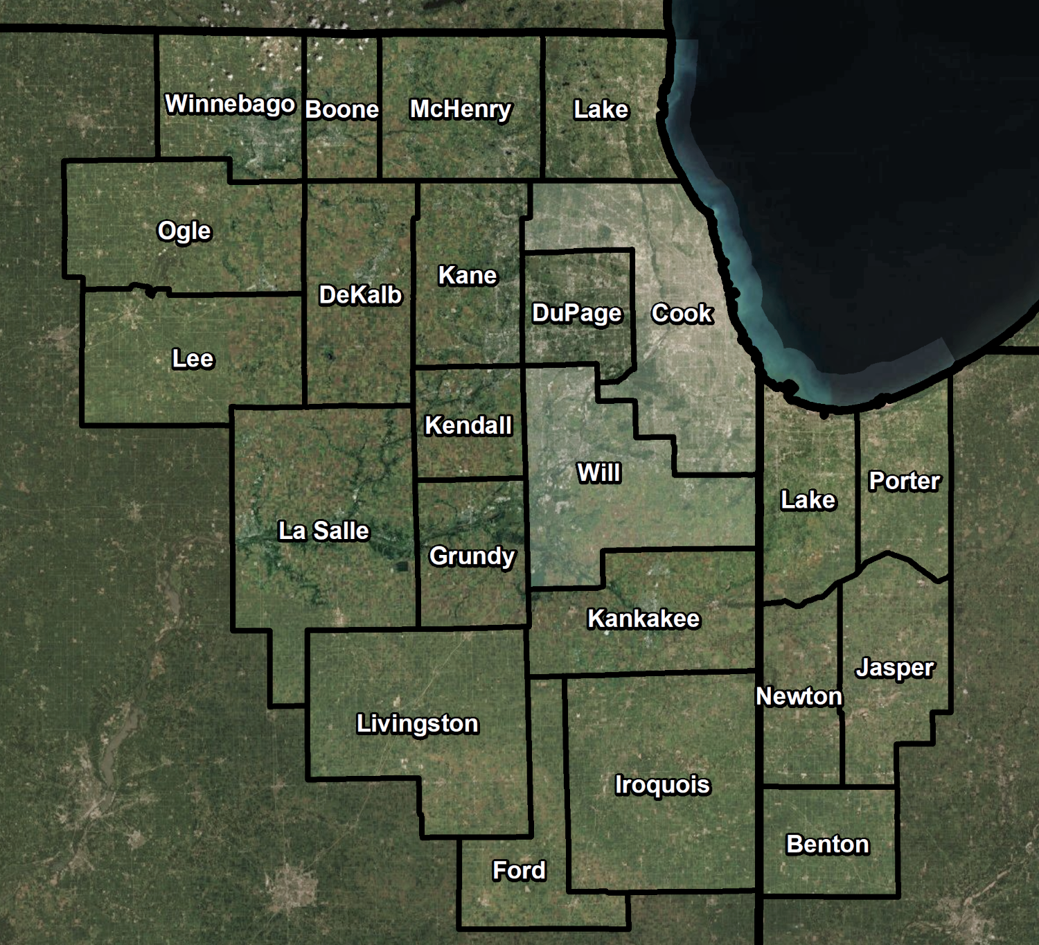
• The NWS issues most watches and warnings for public forecast zones. These usually are the same as counties, but in some cases may be subsets of counties. Counties are subset into zones to allow for more accurate forecasts because of the differences in weather within a county.
• Currently all forecast zones in the NWS Chicago forecast area are county-based.
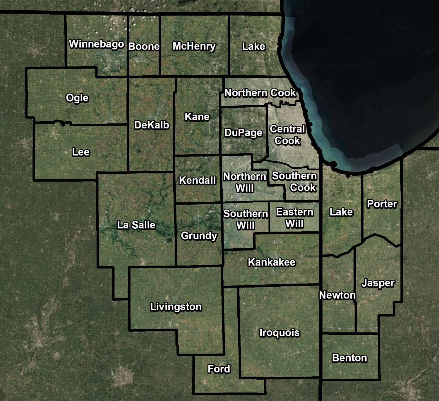
• March 2020: NWS Chicago will reconfigure the Cook County and Will County forecast zones into smaller segments.
 |
 |
| Current NWS Chicago Public Forecast Zones | New NWS Chicago Public Forecast Zones |
 |
 |
| New Cook County Zone Configuration | New Will County Zone Configuration |
Cook County
With a population of approximately 5.2 million people, Cook County is the second most populous county in the United States. Effectively communicating expected weather hazards across Cook County is challenging given its large size (~60 miles NW to SE and ~47 miles N to S), unique geometry and influence from Lake Michigan. The placement of Chicago in the center of the county exacerbates these difficulties when a hazard affects only a portion of the county. If a certain weather event is expected to reach headline criteria across only the northern or southern third of the county, the entire county must be included in the headline. This can effectively over-warn more than four million people in the remainder of the county.
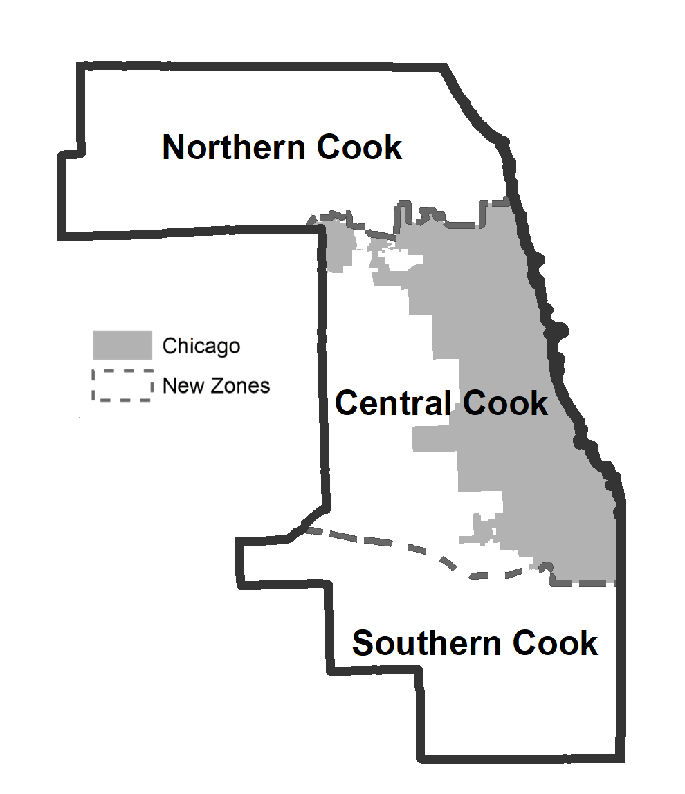
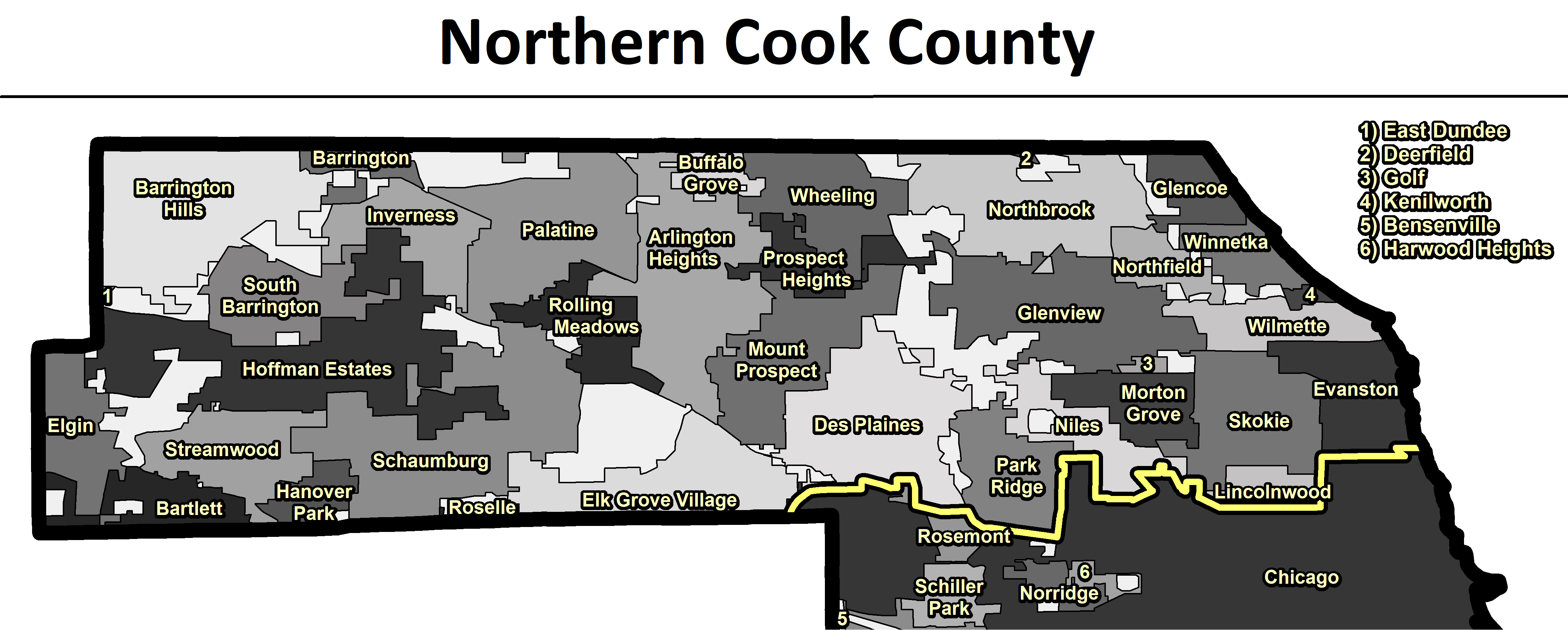
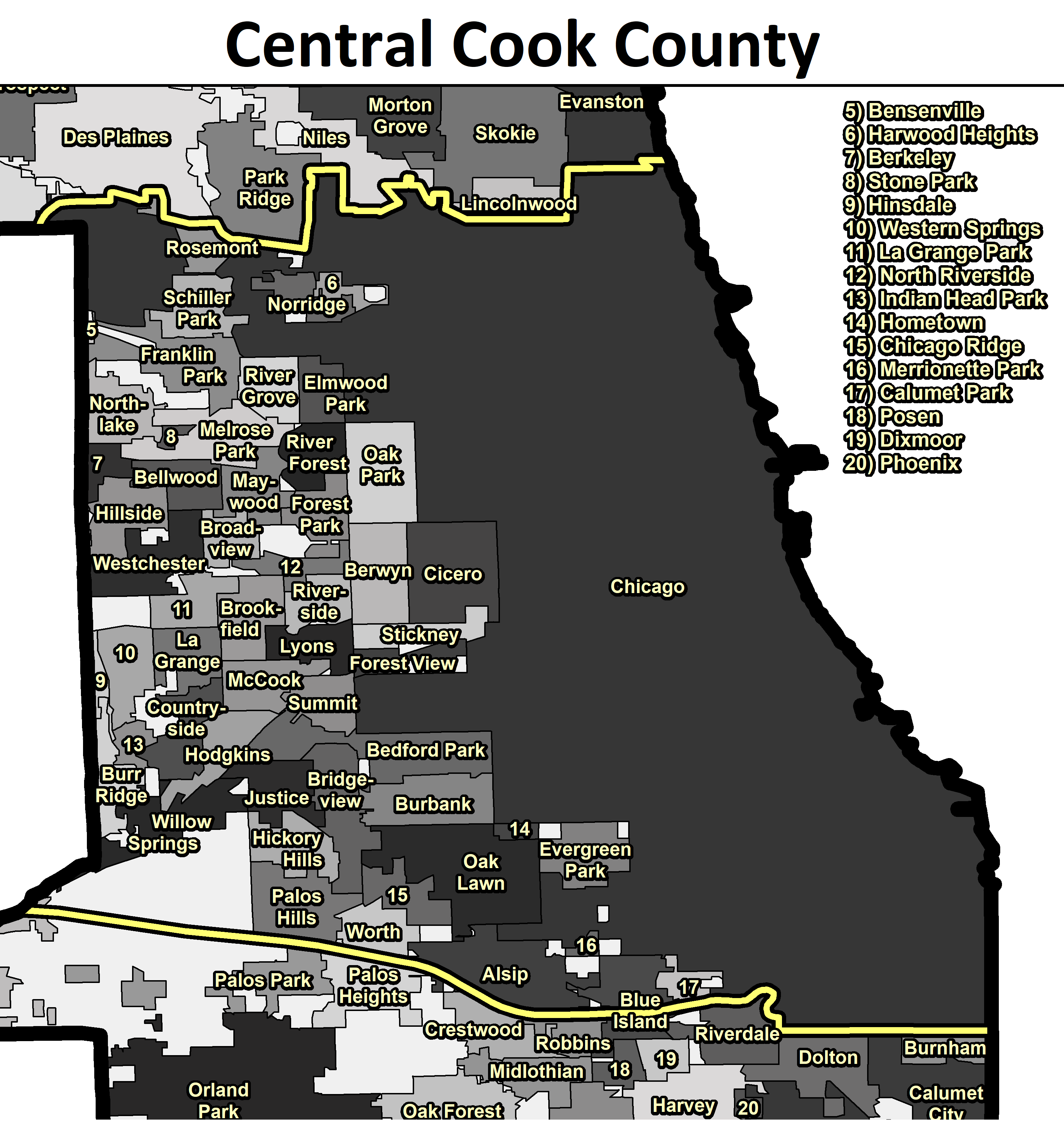
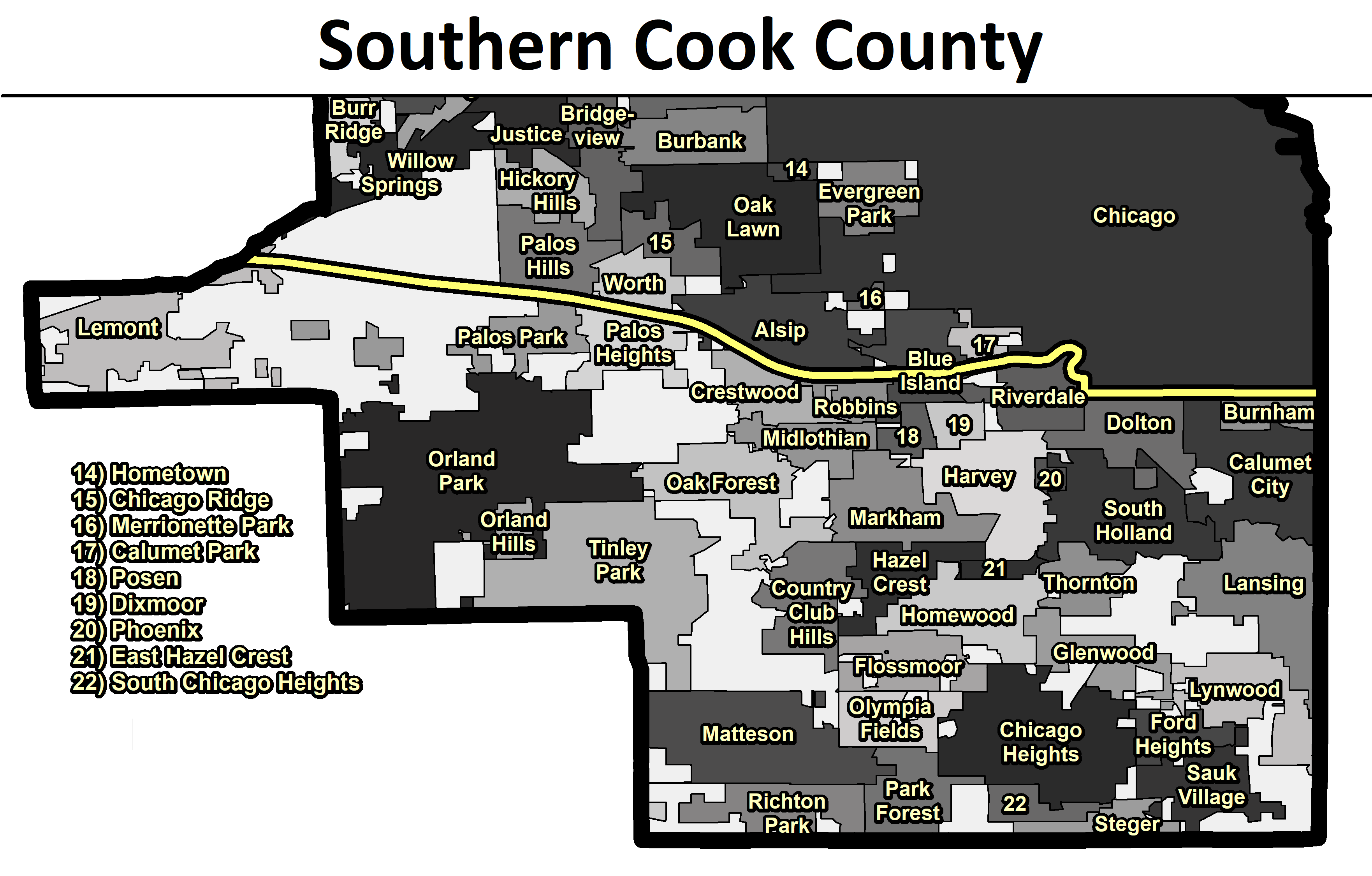
The new split of the Cook County forecast zone into three separate zones will alleviate communication difficulties while also reducing the effective false alarm rate of a significant population when impacts are expected over only a portion of the county. The new alignment, coordinated with officials in Cook County and Chicago, separates the city of Chicago (central Cook County) from the northern and southern portions of the county.
The following images provide a detailed graphical depiction of the new zone configuration. Click each image to expand it to the full size.
 |
Three New Zones: 1) Northern Cook County: North and Northwest Cook Suburbs 2) Central Cook County: Chicago and Western Cook Suburbs 3) Southern Cook County: Southern Cook Suburbs
Northern/Central line: Northern boundary of Chicago Central/Southern line: Far southern boundary of Chicago westward along the Cal-Sag Canal
|
| New Forecast Zone Configuration for Cook County |
 |
| New Forecast Zone Configuration for Cook County |
 |
|
||||||
 |
|
||||||
 |
|
||||||
Will County
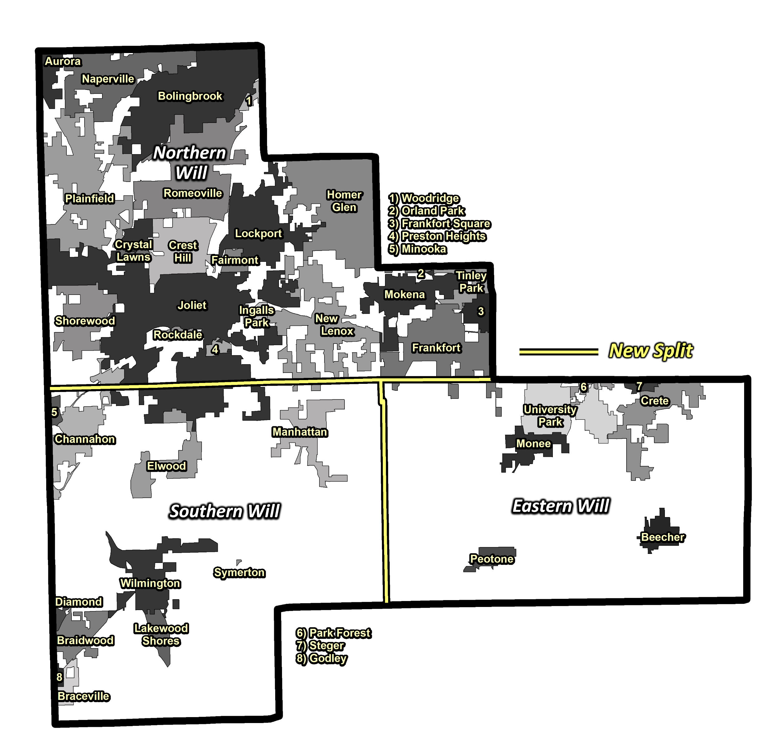
With nearly 700,000 people, Will County is the fourth most populous county in Illinois. ~85% of the population resides in the northern half of the county. The significant difference in land use (urban vs. agricultural) across the county can result in notably different impacts for some weather scenarios. For example, when blizzard conditions are expected over the more open land of southern Will County but not across the northern more urbanized area, over a half million people could be placed under a Blizzard Warning without the expectation of experiencing blizzard conditions.
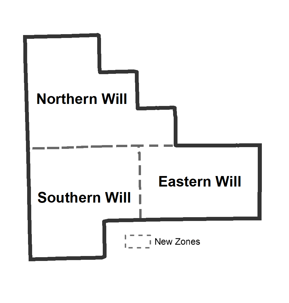
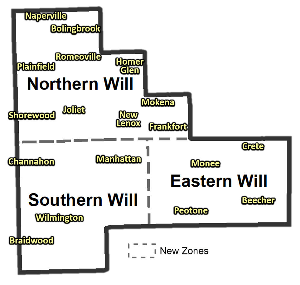
The new split of the Will County forecast zone into three separate zones will alleviate communication difficulties arising from the county’s differing land use. The new alignment, coordinated with officials in Will County, separates the north half of the county from the south half of the county. The south half of the county is further divided into two zones to account for impacts from Lake Michigan across eastern portions of the county. The new zones also better align with surrounding county boundaries and the new Cook County zone configuration.
The following images provide a detailed graphical depiction of the new zone configuration. Click each image to expand it to the full size.
 |
Three New Zones: 1) Northern Will County 2) Southern Will County 3) Eastern Will County
*All zone borders use township lines (map below)
|
| New Forecast Zone Configuration for Will County |
 |
| New Forecast Zone Configuration for Will County |
 |
|
|||||||||
 |
|
|||||||||
What Will Change?
When conditions warrant, NWS Chicago will have the ability to issue most long-term (more than one hour in length) headlines for individual portions of Cook County or Will County. However, short-term (less than one hour in length) headlines will be unaffected, including all severe thunderstorm-related watches and warnings. A breakdown of the affected and unaffected commonly issued headlines are below:
| Affected Common Headlines |
|
| Unaffected Common Headlines |
|
Headlines issued by the Storm Prediction Center
Limited area polygon-based headlines
Additional Headlines that use separate Fire Weather Zones
|
NOAA Weather Radio (NWR)
This change will have no impact on NWR tone alerts. Only minor changes to the text within the NOAA Weather Radio routine broadcast cycle and headlines are expected. No FIPS codes are being changed at this time.
The change here is to an NWS system that will allow forecast maps and GPS-based alert systems to limit the areal extent of most headlines. This means that anyone with a weather app that uses location for alerting should no longer receive headlines if their sub-section of the county is not included.
This is different from FIPS code adjustments. The National Institute of Standards and Technology (NIST) assigns the FIPS codes, so changes are a multi-year process that is complex given all of the dependent systems across not just the NWS, but various other entities across the country. We will investigate the logistics of this change, but any updates would be several years away.
Zone Forecast Product (ZFPLOT)
Each new forecast zone segment will have a separate forecast section. The forecasts listed in those sections will be a general representation of the forecast across the entire zone segment. However, use of the NWS point specific forecast is encouraged, especially when the use of the forecast is for a specific location. The point-specific forecast can be obtained by visiting www.weather.gov/chicago and clicking your location on the map or entering your location in the upper left (for larger cities, it is recommended that you use your zip code.)
Forecast Zone Numbers
New public forecast zone numbers will be assigned to the reconfigured zones. Additionally, the current public forecast zone numbers assigned to Cook and Will counties will be retired. The new zone numbers and names are listed below:
Public Forecast Zones being divided/retired:
|
New Public Forecast Zones:
|
A map of the new forecast zones can be found here.
GIS shapefiles of the new forecast zones can be found here.
* Note: These changes do not affect the Fire Weather Zone configuration and numbers used by NWS Chicago.
Examples
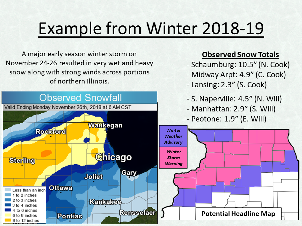
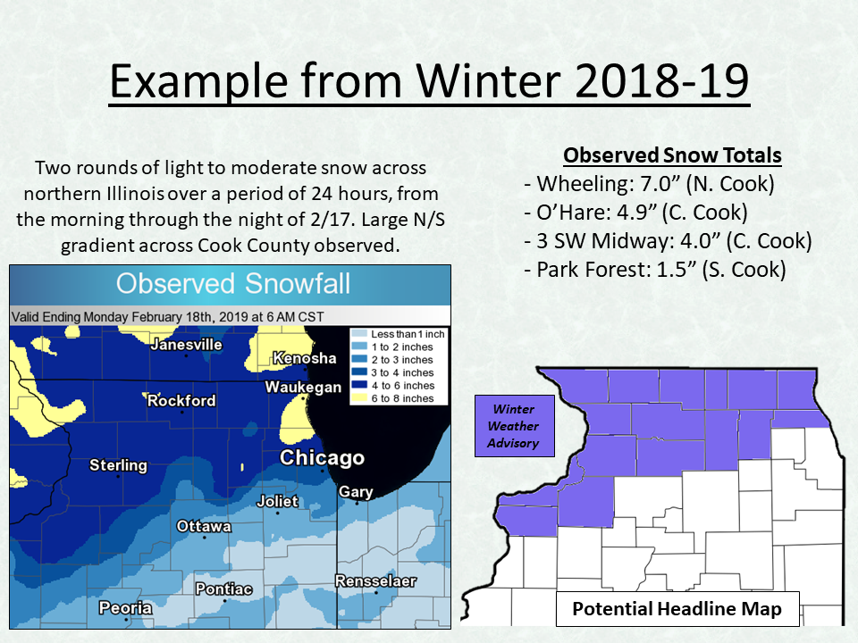
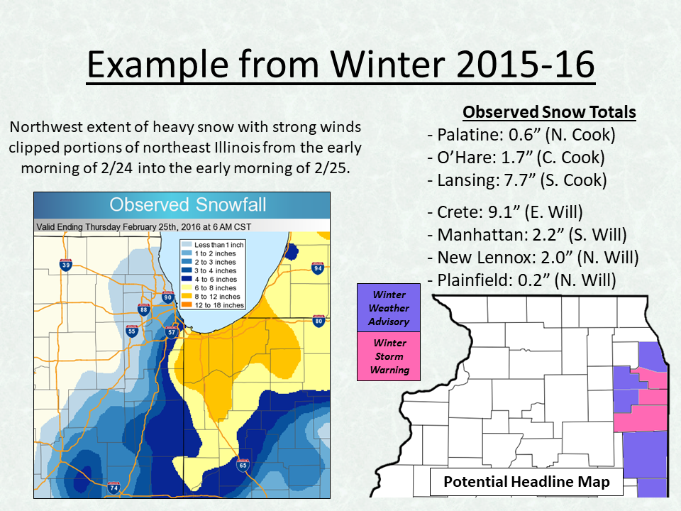
The following images are examples of potential headline maps for various forecast scenarios to demonstrate how the headline map may look.
 |
 |
| Example 1: Both Cook County and Will County split. | Example 2: Only Northern Cook County in headline. |
 |
 |
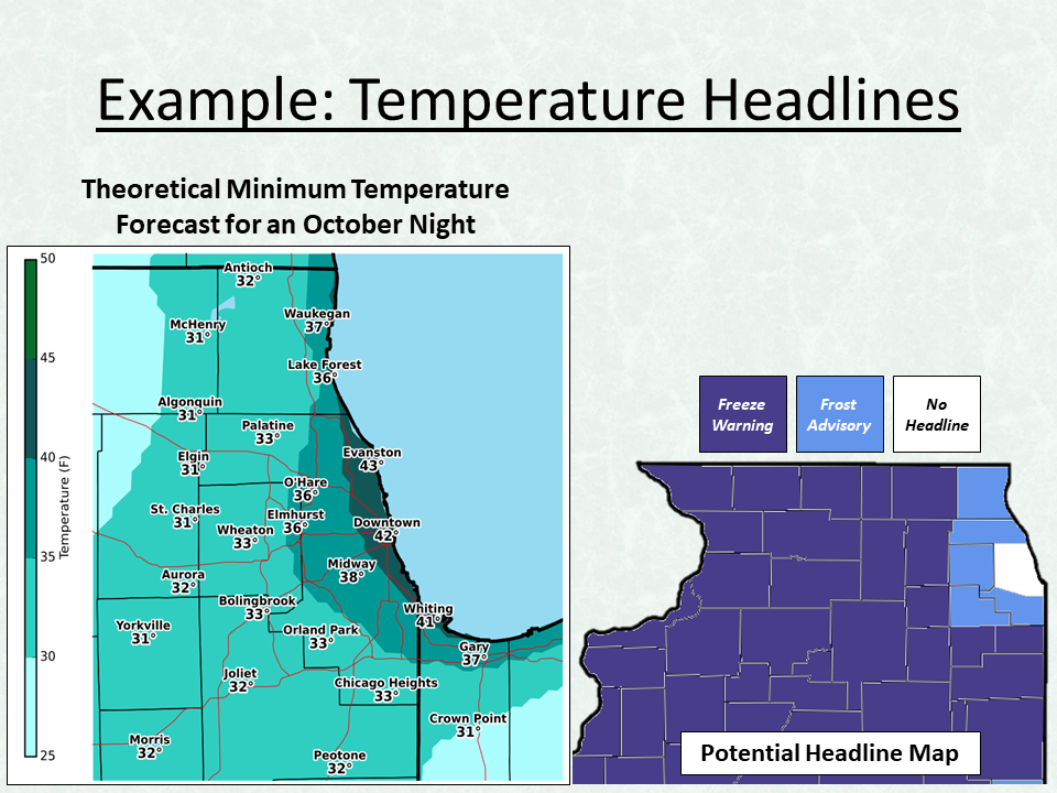
| Example 3: Sharp snowfall gradient affecting southern Chicago metro. | Example 4: Frost and Freeze headlines adjusted for Lake Michigan and urban influences. |
Overview Images
The following are graphical overviews that can be used by government officials, media, and the public to share with interested parties. These graphics have also been shared on the NWS Chicago Facebook and Twitter pages.
 |
 |
 |
Hazards
Enhanced Hazardous Weather Outlook
Hazardous Weather Outlook
National Briefing
Skywarn
Outlooks
Watch/Warning/Advisory Criteria
Snow Squall Warnings
Local Forecasts
Text Products
Aviation
Marine
Fire
Enhanced Data Display (EDD)
Great Lakes Marine Portal
Lake Michigan Beach Forecast
El Nino
Snow and Ice Probabilities
Past Weather
Weather Event Write-Ups
Stormdata
Holiday Climate Data
Climate Plots
Education
Play Time for Kids
Jetstream
Student Opportunities
NWS Training Portal
US Dept of Commerce
National Oceanic and Atmospheric Administration
National Weather Service
Chicago, IL
250 George J Michas Dr.
Romeoville, IL 60446
815-834-1435 8am-8pm
Comments? Questions? Please Contact Us.
Thank you for visiting a National Oceanic and Atmospheric Administration (NOAA) website. The link you have selected will take you to a non-U.S. Government website for additional information.
NOAA is not responsible for the content of any linked website not operated by NOAA. This link is provided solely for your information and convenience, and does not imply any endorsement by NOAA or the U.S. Department of Commerce of the linked website or any information, products, or services contained therein.
You will be redirected to:
