December 2017 will go down in the history books as slightly below normal in temperatures, but well below normal with precipitation and snowfall.
However, 2017 ended up well above normal for temperatures and precipitation. Rockford ranked as the 9th warmest year and Chicago as the 7th warmest. For precipitation, Rockford ranked as the 8th wettest year on record, and Chicago as the 15th wettest year on record.
 |
| Click to enlarge. |
 |
| Click to enlarge. |
 |
| Click to enlarge. |
 |
| Click to enlarge. |
 |
| Click to enlarge. |
| Climate Maps are from the Midwest and Northeast Regional Climate Centers and Illinois State Water Survey |
 |
 |
PUBLIC INFORMATION STATEMENT
NATIONAL WEATHER SERVICE CHICAGO IL
827 AM CST MON JAN 01 2018...Correction to RFD yearly temp rankings

...A Look Back at the Climate for 2017 for Chicago and Rockford...

At Chicago, the average high temperature for 2017 was 61.3 degrees,
which is 2.2 degrees above the 1981 to 2010 average of 59.1
degrees.  The average low temperature was 43.8 degrees, which is 3.0
degrees above the 1981 to 2010 average of 40.8 degrees.  The
mean average temperature for the year was 52.6 degrees, which is 2.7
degrees above the normal average of 49.9 degrees.

A total of 43.10 inches of precipitation was recorded during the
year, which is 6.21 inches above normal.

A total of 13.8 inches of snow was recorded during the year, which
is -22.5 inches below normal.

Records Established During 2017...

JANUARY --
* RECORD DAILY PRECIPITATION OF 0.90 INCHES ON THE 16TH

FEBRUARY --
* RECORD DAILY HIGHEST MAXIMUM TEMPERATURE OF 67 DEGREES ON THE 17TH
* RECORD DAILY HIGHEST MAXIMUM TEMPERATURE OF 70 DEGREES ON THE 18TH
* RECORD DAILY HIGHEST MAXIMUM TEMPERATURE OF 69 DEGREES ON THE 19TH
* RECORD DAILY HIGHEST MAXIMUM TEMPERATURE OF 70 DEGREES ON THE 20TH
* RECORD DAILY HIGHEST MINIMUM TEMPERATURE OF 49 DEGREES ON THE 21ST
* TIED RECORD DAILY HIGHEST MAXIMUM TEMPERATURE OF 68 DEGREES ON THE
  22ND
* RECORD DAILY HIGHEST MINIMUM TEMPERATURE OF 47 DEGREES ON THE 28TH
* 3RD WARMEST FEBRUARY ON RECORD SINCE 1872 WITH 38.1 DEGREES
* TIED FOR LEAST SNOWIEST FEBRUARY ON RECORD WITH A TRACE WTIH 1998
  AND 1987

MARCH --
* RECORD DAILY HIGHEST MAXIMUM TEMPERATURE OF 82 DEGREES ON THE 24TH
* RECORD DAILY PRECIPIATION OF 1.84 INCHES ON THE 30TH

APRIL --
NO RECORDS SET

MAY --
NO RECORDS SET

JUNE --
* RECORD DAILY PRECIPITATION OF 1.30 INCHES ON THE 28TH

JULY --
NO RECORDS SET

AUGUST --
NO RECORDS SET

SEPTEMBER --
* RECORD DAILY HIGHEST MAXIMUM TEMPERATURE OF 92 DEGREES ON THE 20TH
* RECORD DAILY HIGHEST MAXIMUM TEMPERATURE OF 94 DEGREES ON THE 21ST
* RECORD DAILY HIGHEST MAXIMUM TEMPERATURE OF 94 DEGREES ON THE 22ND
* RECORD DAILY HIGHEST MAXIMUM TEMPERATURE OF 95 DEGREES ON THE 23RD
* RECORD DAILY HIGHEST MINIMUM TEMPERATURE OF 72 DEGREES ON THE 23RD
* RECORD DAILY HIGHEST MAXIMUM TEMPERATURE OF 93 DEGREES ON THE 24TH
* RECORD DAILY HIGHEST MAXIMUM TEMPERATURE OF 92 DEGREES ON THE 25TH
* RECORD DAILY HIGHEST MAXIMUM TEMPERATURE OF 92 DEGREES ON THE 26TH

OCTOBER --
* RECORD DAILY PRECIPITATION OF 4.19 INCHES ON THE 14TH

NOVEMBER --
* TIED RECORD DAILY LOWEST MINIMUM TEMPERATURE OF 18 DEGREES ON THE
  10TH

DECEMBER --
* TIED RECORD DAILY LOWEST MAXIMUM TEMPERATURE OF 5 DEGREES ON THE
  26TH


SEASONAL --
* 14TH WETTEST SPRING ON RECORD SINCE 1872 AT 13.72 INCHES

YEARLY --
* 7TH WARMEST YEAR ON RECORD SINCE 1872 WITH 52.6 DEGREES
* 15TH WETTEST YEAR ON RECORD SINCE 1871 WITH 43.10 INCHES
* 4TH LEAST SNOWIEST CALENDAR YEAR ON RECORD SINCE 1884 WITH 13.8
  INCHES

...................................................................

At Rockford, the average high temperature for 2017 was 60.9
degrees,which is 1.6 degrees above the 1981 TO 2010 average of
59.3 degrees.  The average low temperature was 41.3 degrees, which
is 2.1 degrees above the 1981 TO 2010 average of 39.2 degrees.
The mean average temperature for the year was 51.1 degrees, which is
1.9 degrees above the normal average of 49.2 degrees.

A total of 44.67 inches of precipitation was recorded during the
year, which is 8.43 inches above normal.

A total of 10.9 inches of snow was recorded during the year, which
is 25.8 inches below normal.

Records Established During 2017...

JANUARY --
* RECORD DAILY PRECIPITATION OF 1.01 INCHES ON THE 16TH
* 8TH LEAST SNOWIEST JANUARY ON RECORD SINCE 1906 WITH 0.7 INCHES

FEBRUARY --
* RECORD DAILY HIGHEST MAXIMUM TEMPERATURE OF 66 DEGREES ON THE 17TH
* RECORD DAILY HIGHEST MAXIMUM TEMPERATURE OF 68 DEGREES ON THE 18TH
* RECORD DAILY HIGHEST MAXIMUM TEMPERATURE OF 67 DEGREES ON THE 19TH
* RECORD DAILY HIGHEST MAXIMUM TEMPERATURE OF 69 DEGREES ON THE 20TH
* RECORD DAILY HIGHEST MAXIMUM TEMPERATURE OF 67 DEGREES ON THE 21ST
* RECORD DAILY HIGHEST MINIMUM TEMPERATURE OF 43 DEGREES ON THE 21ST
* RECORD DAILY HIGHEST MAXIMUM TEMPERATURE OF 70 DEGREES ON THE 22ND
* RECORD DAILY HIGHEST MINIMUM TEMPERATURE OF 45 DEGREES ON THE 28TH
* RECORD DAILY PRECIPITATION OF 0.76 INCHES ON THE 28TH
* WARMEST FEBRUARY ON RECORD SINCE 1905 WITH 36.8 DEGREES
* TIED FOR 3RD LEAST SNOWIEST FEBRUARY WITH 0.2 INCHES

MARCH --
* TIED RECORD DAILY HIGHEST MAXIMUM TEMPERATURE OF 80 DEGREES ON THE
  24TH
* RECORD DAILY PRECIPITATION OF 1.47 INCHES ON THE 30TH

APRIL --
* RECORD DAILY HIGHEST MINIMUM TEMPERATURE OF 55 DEGREES ON THE 9TH

MAY --
NO RECORDS SET

JUNE --
* RECORD DAILY HIGHEST MINIMUM TEMPERATURE OF 73 DEGREES ON THE 11TH
* RECORD DAILY HIGHEST MINIMUM TEMPERATURE OF 72 DEGREES ON THE 12TH
* RECORD DAILY HIGHEST MINIMUM TEMPERATURE OF 55 DEGREES ON THE 9TH
* RECORD DAILY PRECIPITATION OF 4.11 INCHES ON THE 28TH

JULY --
* RECORD DAILY PRECIPITATION OF 2.45 INCHES ON THE 20TH

AUGUST --
NO RECORDS SET

SEPTEMBER --
* RECORD DAILY HIGHEST MINIMUM TEMPERATURE OF 67 DEGREES ON THE 22ND
* RECORD DAILY HIGHEST MAXIMUM TEMPERATURE OF 93 DEGREES ON THE 23RD
* TIED RECORD DAILY HIGHEST MINIMUM TEMPERATURE OF 66 DEGREES ON THE
  23RD

OCTOBER --
* RECORD DAILY PRECIPITATION OF 1.80 INCHES ON THE 14TH

NOVEMBER --
* RECORD DAILY LOWEST MINIMUM TEMPERATURE OF 14 DEGREES ON THE 10TH
* TIED RECORD DAILY HIGHEST MAXIMUM TEMPERATURE OF 65 DEGREES ON THE
  24TH

DECEMBER --
* TIED FOR 5TH DRIEST DECEMBER ON RECORD SINCE 1905


SEASONAL --
* 8TH WARMEST WINTER ON RECORD (2016-2017) SINCE 1905 AT 29.4 DEGREES
* 6TH WETTEST SPRING ON RECORD SINCE 1906 WITH 14.82 INCHES
* 10TH WETTEST SUMMER ON RECORD SINCE 1906 WITH 17.94 INCHES

YEARLY --
* TIED FOR 9TH WARMEST YEAR ON RECORD SINCE 1906 WITH 51.1 DEGREES
* 8TH WETTEST YEAR ON RECORD SINCE 1905 WITH 44.67 INCHES
* 3RD LEAST SNOWIEST YEAR ON RECORD SINCE 1905 WITH 10.9 INCHES

$$

ACS
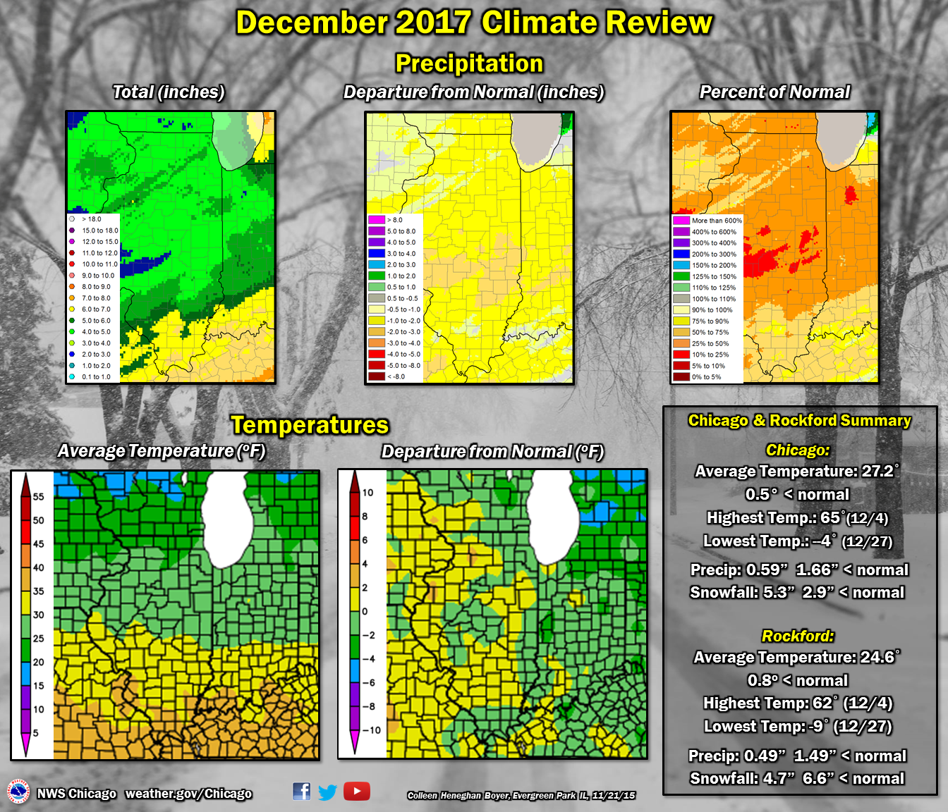
PUBLIC INFORMATION STATEMENT
NATIONAL WEATHER SERVICE CHICAGO/ROMEOVILLE IL
715 AM CST MON JAN 1 2018

...A Look Back at the Climate for the Month of December 2017 for
Chicago and Rockford...

At Chicago, the average high temperature was 34.2 degrees, which is
0.6 degrees below normal. The average low temperature was 20.1
degrees, which is 0.6 degrees below normal. The average temperature
for the month was 27.2 degrees which is 0.5 degrees below normal.
During the month of December, 0.59 inches of precipitation were
recorded, which is 1.66 inches below normal. 5.3 inches of snow were
recorded, which is 2.9 inches below normal.

One record was set for Chicago for the month of December 2017:
* Tied record daily lowest maximum temperature of 5 degrees on the
  26th.


At Rockford, the average high temperature was 32.3 degrees, which is
0.9 degrees below normal. The average low temperature was 16.8
degrees, which is 0.9 degrees below normal. The average temperature
for the month was 24.6 degrees, which is 0.8 degrees below normal.
During the month of December, 0.49 inches of precipitation were
recorded, which is 1.49 inches below normal. 4.7 inches of snow were
recorded, which is 6.6 inches below normal.

There was no daily records for Rockford for the month of December
2017.

One Top Ten Monthly Records:
** Tied for 5th driest December on record since 1905 with 0.49
inches.

$$

