Active hazardous weather continues for the center of the nation with more severe thunderstorms and heavy rainfall today. Heat will linger across the southern Plains, then expand westward early in the week. The combination of heat and dry conditions will fuel fire weather concerns for the Four Corners region and across interior Alaska. Read More >
On February 9, 1870, the NWS was "born" when President Grant signed a Congressional resolution establishing a weather service under the U.S. Army. This later became a civilian agency, the U.S. Weather Bureau, then changed its name to the National Weather Service when it became part of NOAA in 1970.
A big motivation for creating the weather service in 1870 was to help prevent shipwrecks. For this reason, one of the very first forecast offices was located in Chicago to serve the Great Lakes, and NWS Chicago still issues marine forecasts today! However, the NWS mission to protect life and property and enhance the national economy has expanded quite a bit since the early days. Today (for around $4 a year per American) the NWS:
Provides 24x7x365 weather monitoring at local forecast offices all over the country.
Creates detailed forecasts for over 700 airports to support aviation safety and efficiency.
Advises of rip currents and other beach hazards to help avoid drownings.
Deploys incident meteorologists to support firefighters battling wildfires.
Directly supports public officials responsible for safety at outdoor community events.
Forecasts river levels and warns of impending floods.
Issues warnings for a wide variety of threats including tornadoes, large hail, and damaging winds; blizzards and other winter storms; and deadly heat and dangerous cold.
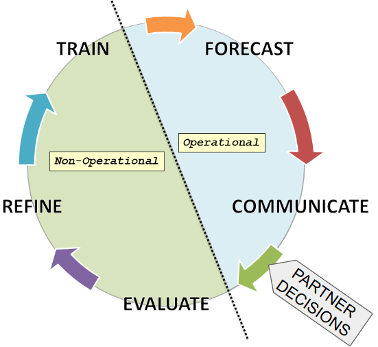
The NWS in Chicago consists of two offices: the Weather Forecast Office (WFO) in Romeoville and the Center Weather Service Unit (CWSU) in Aurora. The primary mission for these offices is twofold: first, to forecast the local weather, and second, to communicate the forecast to anyone and everyone relying on that information to make informed decisions.
Our work is not limited to just forecasting and communicating. We are always evaluating the accuracy of the forecasts and effectiveness of the communication, then refining these processes based on what we learn. We are also constantly training. Our meteorologists are always learning about new tools and forecasting techniques to improve our services, and we work year-round with our partners and the public to help them better utilize NWS information.
The extent to which the National Weather Service supports your daily activities may come as somewhat of a surprise. Some examples:
NWS meteorologists are closely monitoring local weather conditions 24 hours a day. Even in the middle of the night, if a dangerous storm threatens your community, an NWS forecaster is ready to issue a warning and alert you to the hazard.
If you are taking a flight, FAA controllers; airline dispatchers; the crews responsible for maintaining runways, taxiways, and gate areas; and airport public safety managers are utilizing NWS forecasts tailored to each individual airport. NWS technicians also maintain the weather observing equipment at most major airports. NWS meteorologists at CWSUs work side-by-side with FAA controllers to help the US airspace run safely and efficiently.
If you are headed to a beach in the Great Lakes or at the coasts, lifeguards are using NWS surf zone forecasts to help anticipate dangerous swimming conditions such as rip currents.
If you live near a forest preserve or similar open space where prescribed burns are conducted to support a healthy ecosystem, land managers are using NWS fire weather forecasts to make sure the fire burns safely and the smoke is properly dispersed.
If you are at an outdoor concert, fair, parade, cruise night, or other large community event, your local emergency managers are likely in direct contact with NWS meteorologists to help keep event-goers safe. For very large events, an NWS forecaster may actually be onsite at the event providing direct weather support to public safety officials.
If your community is located along a river, NWS hydrologists are continually monitoring water levels and tracking precipitation amounts so they can forecast changes and warn the community of impending floods.
When your school superintendent is wrestling with the difficult decision of whether to cancel school due to cold temperatures or winter weather, the NWS is available to help support their planning.
When extreme heat threatens, health officials use NWS forecasts to help decide when to initiate various response plans, such as opening cooling shelters.
Local TV meteorologists are independent from the NWS but even the most experienced ones utilize NWS information, and much of the data they show originates from the NWS. There is in fact an extensive private weather industry to serve clients with specialized needs that go beyond the basic NWS mission.
In addition to maintaining weather observing equipment at airports, local technicians at NWS Chicago also maintain other critical equipment including our dual-polarization Doppler radar, eleven NOAA Weather Radio transmitters, and three coastal observing platforms, not to mention all of the IT equipment in our office as well as the facility itself.
Given that each local NWS office has only 13-14 forecasters (if fully staffed), it should be noted that all of this work is conducted by just 2-3 forecasters at a time on a given shift, though additional staff can be brought in to provide support as needed. When not working operational shifts to produce and deliver forecasts and warnings, NWS Chicago meteorologists devote their time to activities on the "Evaluate, Refine, and Train" side of the "What We Do" cycle above.
Meteorologists at local NWS forecast offices have an intimate knowledge of their geographical area. This includes both the unique nuances of the local weather, as well as partners at the federal, state, county, and community level listed in the examples above. We meet in person with many of these partners throughout the year to conduct planning and training exercises.
All of the forecast and warning information provided by the NWS is of course openly available to the general public as well, since they have already paid for it through their federal tax dollars. This is in addition to all the data from Doppler radars, satellites, computer models, and surface observation sites maintained and managed by NOAA and the NWS.