Meteorology | Winds | Waves | Photos | Storm Reports | Other Links
For a listing on the national scale of maximum winds, as well as highest rainfall and snowfall totals, please see this Storm Summary from the NWS Weather Prediction Center.
|
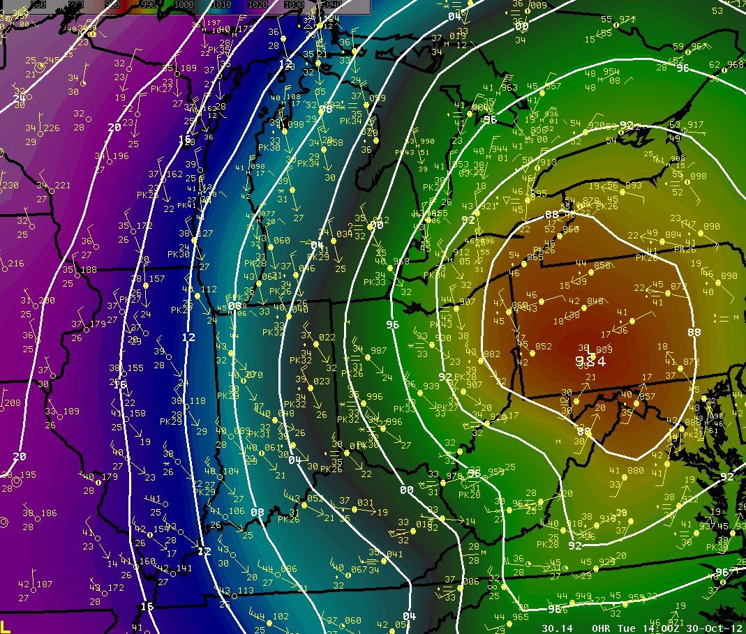
October 30th, 9 am: Surface Weather Map with Observations Overlaid |
|
|
|
Sea-level pressure is the image. The contours are pressures every 4 mb. The impressively tight gradient extends far west of the center of circulation of Sandy's remnants, all the way to Lake Michigan in fact. The pressure gradient force is dominant in causing air to move, or creating wind, and this was very strong at this time. |
|
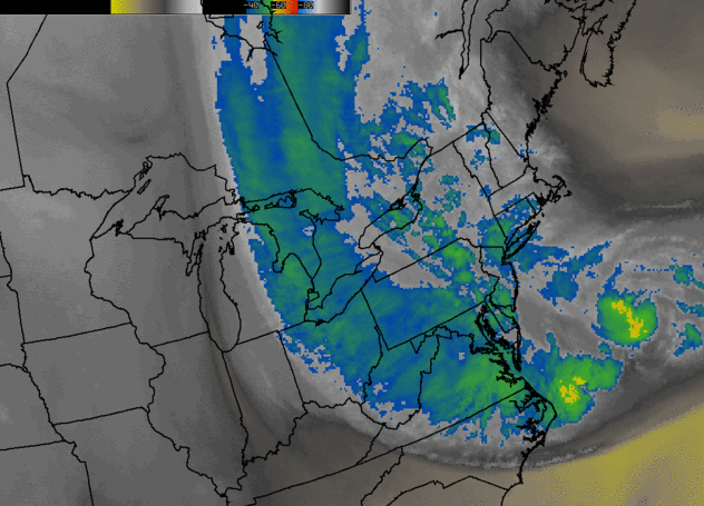
October 30th 4 am - 11 am GOES Satellite Infrared/Water Vapor Combination Loop |
|
|
|
The massive extent to the circulation of Sandy was potentially one for the record books. This loop shows the circulation center accelerating into New Jersey. The upper atmospheric drier and cooler air (indicated by lighter shades) wraps into the system from the south and east after it makes landfall, which is a sign of the ongoing phasing with an upper level trough at that time. This trough had brought the Great Lakes region the below normal temperatures late last week into this week. This phasing of system led to the strong winds being prolonged for a long period of time and over a significantly large area. |
While tropical cyclones rarely come as far north and west as northern Illinois and Indiana such as Isaac had in September, tropical cyclones can still have impacts on the local area even when remaining over a thousand miles away. A tropical system, or its remnants that become "extratropical", can have a massive radius of influence on the weather pattern, such as Sandy did. Because of their size and depth, they can alter, shift, or slow a typical jet stream regime, changing the progress of other weather systems. Sandy did just that. It blocked the strong west to northwest flow that is usually developing this time of year, and led the pattern to be blocked over the area. This kept the cooler than normal temperatures in place, along with halting any other weather systems. This actually kept northern Illinois dry for several days and will continue to through the latter part of the week.
PUBLIC INFORMATION STATEMENT
NATIONAL WEATHER SERVICE CHICAGO IL
1134 PM CDT TUE OCT 30 2012 /1234 AM EDT WED OCT 31 2012/

...HIGHEST OBSERVED WINDS FROM LAKE MICHIGAN...NORTHWEST INDIANA...
AND NORTHEAST ILLINOIS FROM REMNANTS OF SANDY...

MARITIME...

...LOCATION...                         ...TIME...     ...WIND...
3 WNW MICHIGAN CITY (70 FT)            845 AM OCT 30      69 MPH
CHICAGO HARRISON-DEVER CRIB (85 FT)    830 AM OCT 30      58 MPH
SOUTH BUOY                             950 AM OCT 30      56 MPH
4 NE EAST CHICAGO (SHIP)               500 AM OCT 30      54 MPH
BURNS HARBOR                           850 AM OCT 30      52 MPH
NORTH BUOY                             450 PM OCT 30      49 MPH
WAUKEGAN HARBOR                        940 AM OCT 30      42 MPH


LAND...

GARY REGIONAL AIRPORT (LAKE IN)       1145 AM OCT 30      60 MPH
1 WNW NEW CHICAGO (LAKE IN)            134 AM OCT 30      50 MPH
PORTER COUNTY MUNICIPAL AIRPORT        707 AM OCT 30      49 MPH
2 SW VALPARAISO (PORTER IN)            632 AM OCT 30      49 MPH
2 WNW BURNHAM (COOK IL)                100 AM OCT 30      47 MPH
EAST CHICAGO (LAKE IN)                1242 AM OCT 30      45 MPH
LOCKPORT (WILL IL)                    1100 AM OCT 30      44 MPH
2 E LAKEMOOR (LAKE IL)                 735 AM OCT 30      44 MPH
2 SE HOBART (LAKE IN)                  716 AM OCT 30      44 MPH
CHICAGO MIDWAY AIRPORT (COOK IL)      1051 AM OCT 30      43 MPH
2 W CHICAGO (COOK IL)                 1218 PM OCT 30      43 MPH
1 SE SOUTH CHICAGO (COOK IL)          1112 PM OCT 29      42 MPH
1 WSW EAST CHICAGO (LAKE IN)           125 AM OCT 30      41 MPH
SOUTH HOLLAND (COOK IL)                100 PM OCT 30      40 MPH

OBSERVATIONS ARE COLLECTED FROM A VARIETY OF SOURCES WITH VARYING
EQUIPMENT AND EXPOSURES. NOT ALL DATA LISTED IS CONSIDERED
OFFICIAL. THE NATIONAL WEATHER SERVICE THANKS ITS PRIVATE AND
PUBLIC PARTNERS FOR PROVIDING US WITH THIS DATA.

$$
|
|
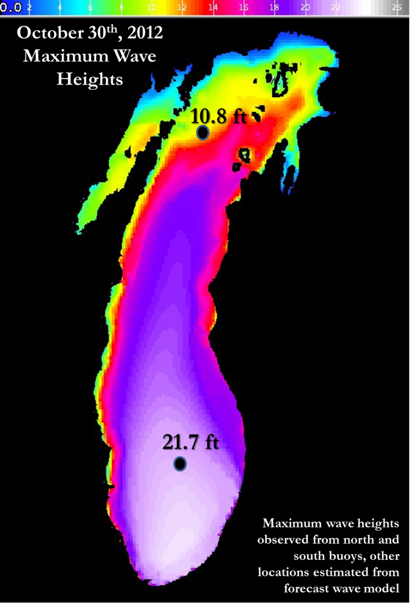
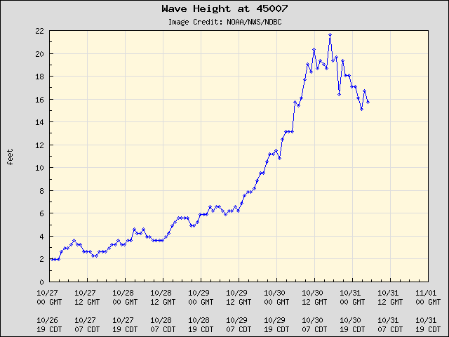
PUBLIC INFORMATION STATEMENT
NATIONAL WEATHER SERVICE CHICAGO IL
1208 AM CDT WED OCT 31 2012 /108 AM EDT WED OCT 31 2012/

...NEAR RECORD WAVE HEIGHTS ON SOUTHERN LAKE MICHIGAN...

THE 12 PM OCTOBER 30TH OBSERVATION FOR THE SOUTH MID-LAKE
BUOY...WHICH IS LOCATED APPROXIMATELY 43 MILES EAST SOUTHEAST OF
MILWAUKEE...RECORDED WAVES OF 21.7 FT. THIS STORM RANKS AS SECOND
HIGHEST WITH RESPECT TO WAVES EVER RECORDED AT THE SOUTH MID-LAKE
BUOY.
|
Rank |
Storm Date |
Peak Wave |
|
1 |
9/30/2011 |
22.9 ft |
|
2 |
10/30/2012 |
21.7 ft |
|
3 |
11/11/1998 |
20.3 ft |
|
4 |
10/20/2011 |
19.2 ft |
|
5 |
9/23/1989 |
18.4 ft |
RECORDS FOR THE SOUTH MID-LAKE BUOY DATE BACK TO 1981...HOWEVER
THE BUOY IS ONLY DEPLOYED SEASONALLY TYPICALLY FROM EARLY SPRING
THROUGH LATE FALL.IT IS CERTAINLY POSSIBLE THAT LARGER WAVES
COULD HAVE OCCURRED ON LAKE MICHIGAN DURING THE WINTER WHEN THE
BUOY WAS NOT DEPLOYED...SO THESE VALUES REPRESENT THE HIGHEST
VALUES ON RECORD.

WHAT MAKES THE STORM EVEN MORE REMARKABLE IS THE DURATION OF
EXTREMELY HIGH WAVES. AT THE SOUTH BUOY EVERY HOURLY OBSERVATION
FROM 5 AM THROUGH 2  PM ON OCTOBER 30TH HAD WAVE HEIGHTS OF 18 FT
OR GREATER...WHICH IS TEN HOURS OF 18 FOOT WAVES. GOING BACK
THROUGH THE 31 YEARS OF ARCHIVED DATA FROM THE MID-LAKE SOUTH
BUOY...THIS IS A NEW RECORD FOR MOST NUMBER OF CONSECUTIVE HOURLY
OBSERVATIONS WITH WAVES 18 FEET OR GREATER SURPASSING THE NOVEMBER
10-11 1998 EVENT WHEN THERE WERE SEVEN CONSECUTIVE HOURLY
OBSERVATIONS WITH WAVES 18 FEET OR GREATER. OCTOBER 30TH ALSO SAW
THREE MORE HOURS OF 18 FT OR HIGHER WAVES LATER IN THE
DAY...MAKING 13 HOURS TOTAL. PRIOR TO OCTOBER 30TH THERE HAD ONLY
BEEN 15 HOURLY OBSERVATIONS WITH WAVE HEIGHTS OF 18 FEET OR
HIGHER ON RECORD...WHICH REALLY SPEAKS TO HOW REMARKABLE THE WAVES
WERE WITH THIS STORM.

$$

IZZI/MTF
|
North Buoy Observations |
|
|
Winds and Air Pressure |
Wave Heights |
|
|
|
|
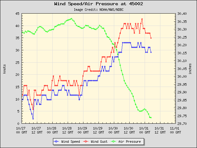
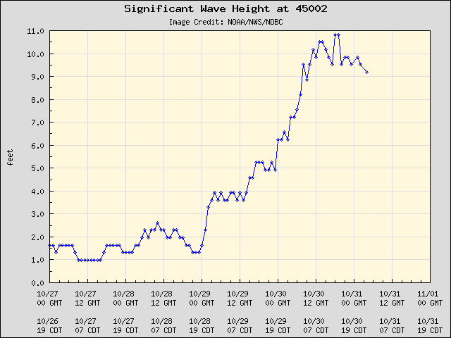
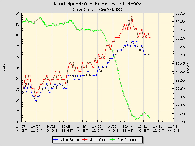
South Buoy Observations - Second Highest Observed Waves on Record |
|
|
Winds and Air Pressure |
Wave Heights |
|
|
|
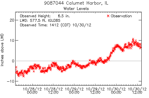
As a result of the prolonged north winds, the Lake Michigan water levels rose substantially as well. Lake levels had been running several inches below normal. These then rose to a peak of nearly 10" above normal from Monday into early Tuesday. Here is an image from early Tuesday afternoon showing the change in Lake Michigan water levels from Calumet Harbor, IL.
|
|
|
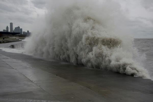
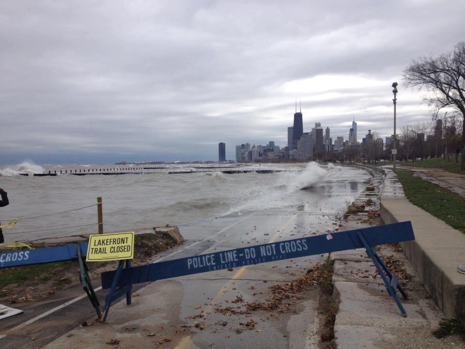
Just north of 31st St Beach in Chicago Photo courtesy of William Ruting |
|
|
|
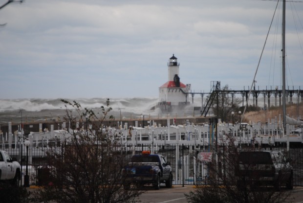
Michigan City Photo taken by the Michigan City Police Department |
PRELIMINARY LOCAL STORM REPORT...SUMMARY
NATIONAL WEATHER SERVICE CHICAGO/ROMEOVILLE IL
1000 AM CDT WED OCT 31 2012

..TIME...   ...EVENT...      ...CITY LOCATION...     ...LAT.LON...
..DATE...   ....MAG....      ..COUNTY LOCATION..ST.. ...SOURCE....
            ..REMARKS..

0500 AM     NON-TSTM WND GST 8 ENE EAST CHICAGO      41.69N 87.31W
10/30/2012  M54.00 MPH       LMZ744             IN   SHIP

0540 AM     NON-TSTM WND DMG DUNE ACRES              41.64N 87.10W
10/30/2012                   PORTER             IN   PARK/FOREST SRVC

            12-14 INCH DIAMETER TREE BLOCKING ROUTE 49, INSIDE
            INDIANA DUNES STATE PARK IN CHESTERTON. ALSO 3 SMALL
            TREES DOWN ACROSS IDSP ROADS.

0730 AM     NON-TSTM WND GST CHESTERTON              41.60N 87.06W
10/30/2012  M50.00 MPH       PORTER             IN   TRAINED SPOTTER

            NEAR INDIANA DUNES. ALSO ESTIMATED WAVES AT 8 TO 12 FT.

0800 AM     COASTAL FLOOD    CHICAGO                 41.88N 87.63W
10/30/2012                   COOK               IL   LAW ENFORCEMENT

            BIKE PATH NEAR THE LAKE MICHIGAN SHORE FLOODED IN AREAS.
            NEARBY PARK AND BEACH AREAS FLOODED.

0830 AM     NON-TSTM WND GST 4 NE CHICAGO            41.92N 87.57W
10/30/2012  M58.00 MPH       LMZ741             IL   C-MAN STATION

            MEASURED AT HARRISON-DEVER CRIB.

0845 AM     NON-TSTM WND GST 2 NNE TOWN OF PINES     41.72N 86.94W
10/30/2012  M69.00 MPH       LMZ745             IN   C-MAN STATION

            60KT GUST AT MICHIGAN CITY INDIANA...MCYI3

0900 AM     COASTAL FLOOD    4 ENE DUNE ACRES        41.67N 87.03W
10/30/2012                   PORTER             IN   BROADCAST MEDIA

            WATER UP TO THE STAIRS THAT LEAD TO THE BEACH AT BROADWAY
            ST AND LAKE FRONT DR. BEACH AT THIS LOCATION IN BEVERLY
            SHORES IS APPROXIMATELY 100 YARDS WIDE.

0930 AM     NON-TSTM WND DMG DUNE ACRES              41.64N 87.10W
10/30/2012                   PORTER             IN   PARK/FOREST SRVC

            12 VEHICLE STORAGE BUILDING AT INDIANA DUNES STATE PARK
            HQ HAD ROOF TORN OFF AND REAR WALL COLLAPSED. DAMAGE TO 4
            VEHICLES.

1145 AM     NON-TSTM WND GST 4 WNW GARY              41.62N 87.42W
10/30/2012  M60.00 MPH       LAKE               IN   AWOS

            MEASURED AT GARY AIRPORT.


&&