Overview
|
Fast Facts: A line of strong to severe thunderstorms rolled through portions of northern Illinois and northwest Indiana during the afternoon of Sunday, June 30th. Numerous wind gusts in excess of 60 mph were received with widespread tree damage across the region. Portions of Kankakee County were particularly hard hit by very high winds. Damage photos, reports, and radar imagery indicate that straight line winds of 70 to 80 mph occurred near Manteno and Momence where dozens of large trees were damaged--some of which were toppled onto houses and cars. |
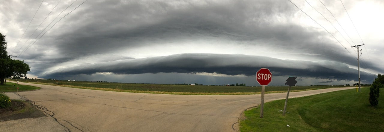
 Large shelf cloud rolling into Polo, IL. Photo courtesy of Tim Bejster. |
Storm Reports
 |
| Storm Reports From June 30th. |
PRELIMINARY LOCAL STORM REPORT...SUMMARY
NATIONAL WEATHER SERVICE CHICAGO IL
430 PM CDT MON JUL 1 2019

..TIME...   ...EVENT...      ...CITY LOCATION...     ...LAT.LON...
..DATE...   ....MAG....      ..COUNTY LOCATION..ST.. ...SOURCE....
            ..REMARKS..

1240 PM     TSTM WND DMG     4 ENE WINNEBAGO         42.28N 89.17W
06/30/2019                   WINNEBAGO          IL   PUBLIC

            PUBLIC REPORTS MULTIPLE TREES DOWNED IN
            VICINITY OF MERIDIAN ROAD AND WEST STATE.
            RELAYED VIA BROADCAST MEDIA. TIME ESTIMATED
            BY RADAR.

1250 PM     TSTM WND DMG     1 SW NEW MILFORD        42.17N 89.07W
06/30/2019                   WINNEBAGO          IL   PUBLIC

            PUBLIC REPORTS TREE DOWNED NEAR BAXTER ROAD
            AND IL-251. RELAYED VIA BROADCAST MEDIA.

1250 PM     TSTM WND DMG     5 NE BYRON              42.18N 89.20W
06/30/2019                   OGLE               IL   PUBLIC

            PUBLIC REPORTS SEVERAL TREES DOWNED ALONG
            IL-2 BETWEEN KENNEDY HILL ROAD AND PRAIRIE
            ROAD BETWEEN BYRON AND ROCKFORD. RELAYED VIA
            MEDIA. TIME ESTIMATED BY RADAR.

0100 PM     TSTM WND GST     ROCKFORD AIRPORT        42.20N 89.10W
06/30/2019  M63 MPH          WINNEBAGO          IL   ASOS

            ASOS RFD.

0100 PM     TSTM WND DMG     2 S WONDER LAKE         42.35N 88.35W
06/30/2019                   MCHENRY            IL   PUBLIC

            NUMEROUS LARGE BRANCHES DOWNED. DAMAGE TO
            SIDING. TIME ESTIMATED BY RADAR.

0115 PM     TSTM WND DMG     OREGON                  42.02N 89.33W
06/30/2019                   OGLE               IL   TRAINED SPOTTER

            MINOR DAMAGE TO TREES IN OREGON.

0120 PM     TSTM WND DMG     1 SSE WAUCONDA          42.25N 88.13W
06/30/2019                   LAKE               IL   PUBLIC

            NUMEROUS LARGE BRANCHES DOWNED NEAR US-12
            AND LAKESHORE DRIVE IN WAUCONDA. ONE BRANCH
            ABOUT 8-IN DIAMETER. TIME ESTIMATED BY
            RADAR.

0120 PM     TSTM WND DMG     1 E TOWER LAKES         42.23N 88.14W
06/30/2019                   LAKE               IL   EMERGENCY MNGR

            POWERLINES AND TREES DOWNED BLOCKING ROADS
            IN NORTH BARRINGTON AND WAUCONDA AREAS.

0120 PM     TSTM WND GST     3 N DEKALB              41.98N 88.75W
06/30/2019  E50 MPH          DE KALB            IL   TRAINED SPOTTER

            MINOR TREE DAMAGE.

0120 PM     TSTM WND DMG     CARY                    42.21N 88.25W
06/30/2019                   MCHENRY            IL   PUBLIC

            PHOTO SHARED VIA SOCIAL MEDIA OF LARGE TREE
            BRANCH DOWNED ON TO POWER LINES. TIME
            ESTIMATED VIA RADAR.

0125 PM     TSTM WND DMG     1 WNW BARRINGTON        42.16N 88.15W
06/30/2019                   LAKE               IL   PUBLIC

            TREE DOWN ON MAIN STREET AND DUNDEE. TIME
            ESTIMATED BY RADAR.

0134 PM     TSTM WND DMG     2 NNE BIG ROCK          41.79N 88.53W
06/30/2019                   KANE               IL   TRAINED SPOTTER

            VIDEO AND DETAILED DESCRIPTION SHOWING TWO
            WELL-DEFINED GUSTNADOS AT THE CORNER OF
            SCOTT AND DAUBERMAN ROADS. DEBRIS WAS BLOWN
            OVER 3/4 OF A MILE TO THE SOUTH.

0135 PM     TSTM WND DMG     ELK GROVE VILLAGE       42.00N 88.00W
06/30/2019                   COOK               IL   BROADCAST MEDIA

            PICTURE SHARED VIA SOCIAL MEDIA OF LARGE
            COMMERCIAL SIGN BLOWN DOWN ON TO A CAR.

0135 PM     TSTM WND DMG     2 E PALATINE            42.11N 88.00W
06/30/2019                   COOK               IL   PUBLIC

            NUMEROUS TREE BRANCHES DOWNED IN VICINITY OF
            PALATINE ROAD AND IL-53. MAX DIAMETER AT
            LEAST 6-IN. RELAYED VIA SOCIAL MEDIA. TIME
            ESTIMATED BY RADAR.

0140 PM     TSTM WND DMG     1 W CAROL STREAM        41.91N 88.15W
06/30/2019                   DUPAGE             IL   PUBLIC

            MULTIPLE LARGE BRANCHES DOWNED.

0150 PM     TSTM WND DMG     1 WNW LOMBARD           41.89N 88.03W
06/30/2019                   DUPAGE             IL   LAW ENFORCEMENT

            GLEN ELLYN PD REPORTS VIA SOCIAL MEDIA POWER
            LINES AND TREES DOWNED NEAR ST CHARLES AND
            CRESCENT. TIME ESTIMATED BY RADAR.

0150 PM     TSTM WND DMG     1 NW VILLA PARK         41.90N 87.99W
06/30/2019                   DUPAGE             IL   PUBLIC

            MULTIPLE 4 IN DIAMETER BRANCHES DOWNED.
            RELAYED VIA SPOTTER NETWORK. TIME ESTIMATED
            BY RADAR.

0154 PM     TSTM WND GST     OHARE AIRPORT           41.98N 87.90W
06/30/2019  M60 MPH          COOK               IL   OFFICIAL NWS OBS

            **DELAYED REPORT** OHARE AIRPORT GUSTED TO
            60 MPH. ONCE AT 1:54 PM AND AGAIN AT 2:01
            PM.

0212 PM     TSTM WND DMG     4 NW SHOREWOOD          41.56N 88.27W
06/30/2019                   KENDALL            IL   NWS EMPLOYEE

            THREE LARGE TREE LIMBS DOWN. LIMB DIAMETERS
            RANGE FROM 6 INCHES TO ONE FOOT. TIME
            ESTIMATED BASED ON RADAR.

0212 PM     TSTM WND DMG     2 SSE NAPERVILLE        41.75N 88.14W
06/30/2019                   DUPAGE             IL   NWS EMPLOYEE

            PHOTOS OF SEVERAL LARGE (UP TO 6 INCH
            DIAMETER) TREE LIMBS SNAPPED. TIME ESTIMATED
            BASED ON RADAR SIGNATURES.

0213 PM     TSTM WND DMG     MENDOTA                 41.55N 89.12W
06/30/2019                   LA SALLE           IL   LAW ENFORCEMENT

            LARGE PORTION OF TREE DOWNED ON ELECTRICAL
            WIRES, SNAPPING TOP PORTION OF ADJACENT
            POLE. TIME ESTIMATED ON RADAR.

0215 PM     NON-TSTM WND GST 2 WNW LOCKPORT          41.60N 88.10W
06/30/2019  M60 MPH          WILL               IL   AWOS

            AWOS STATION KLOT.

0227 PM     TSTM WND DMG     1 SSE WILMINGTON        41.30N 88.14W
06/30/2019                   WILL               IL   LAW ENFORCEMENT

            WILMINGTON SO REPORTS WIDESPREAD TREE DAMAGE
            ACROSS THE TOWN OF WILMINGTON. ROUTE 102 IS
            BLOCKED BY LARGE TREES ACROSS THE ROADWAY.

0230 PM     TSTM WND GST     MANHATTAN               41.43N 87.99W
06/30/2019  E60 MPH          WILL               IL   PUBLIC

            WINDS ESTIMATED GREATER THAN 60 MPH NEAR
            US-52 IN MANHATTAN.

0239 PM     TORNADO          2 ESE GILMAN            40.75N 87.95W
06/30/2019                   IROQUOIS           IL   PUBLIC

            SEVERAL PHOTOS SHOWING A LANDSPOUT TORNADO
            IMMEDIATELY ESE OF GILMAN. TIME MATCHED
            BASED ON RADAR AND TIME STAMPS ON SOCIAL
            MEDIA IMAGES.

0240 PM     TSTM WND DMG     1 N STREATOR            41.14N 88.83W
06/30/2019                   LA SALLE           IL   LAW ENFORCEMENT

            RELAYED VIA THE LIVINGSTON COUNTY SO:
            WIDESPREAD TREE DAMAGE IN AND AROUND
            STREATOR. AWNINGS AND LIMBS ON HOUSES AND
            CARS THROUGHOUT THE AREA. TIME ESTIMATED
            BASED ON RADAR.

0245 PM     TSTM WND DMG     MANHATTAN               41.42N 87.98W
06/30/2019                   WILL               IL   EMERGENCY MNGR

            65 MPH WIND GUST ESTIMATED. SMALL BRANCHES
            DOWNED.

0255 PM     HEAVY RAIN       1 ESE CREST HILL        41.55N 88.09W
06/30/2019  M2.00 INCH       WILL               IL   PUBLIC

            PUBLIC REPORTS 2 INCHES OF RAIN IN ABOUT 30
            MINUTES JUST NORTH OF JOLIET.

0300 PM     FLOOD            1 NNW MINOOKA           41.47N 88.27W
06/30/2019                   KENDALL            IL   PUBLIC

            SOCIAL MEDIA POST INDICATING FLOODING AT
            INTERSECTION OF HOLT ROAD AND RIDGE ROAD
            NEAR MINOOKA.

0300 PM     TSTM WND DMG     ODELL                   41.00N 88.52W
06/30/2019                   LIVINGSTON         IL   LAW ENFORCEMENT

            POWERLINES DOWN IN ODELL.

0300 PM     TSTM WND DMG     3 WNW GRANT PARK        41.26N 87.70W
06/30/2019                   KANKAKEE           IL   AMATEUR RADIO

            POWER LINES DOWNED AND SHINGLES OFF ROOF
            NORTH OF GRANT PARK. ALSO 30 FOOT TREE
            SNAPPED.

0300 PM     TSTM WND DMG     MOMENCE                 41.16N 87.66W
06/30/2019                   KANKAKEE           IL   EMERGENCY MNGR

            KANKAKEE EMERGENCY MANAGEMENT REPORTS
            NUMEROUS TREES DOWN IN THE MOMENCE AREA
            INCLUDING TREES DOWNED ON TO RESIDENCES.
            TIME ESTIMATED BY RADAR.

0300 PM     HEAVY RAIN       2 WSW CREST HILL        41.54N 88.14W
06/30/2019  M1.18 INCH       WILL               IL   COCORAHS

            RAINFALL PAST 45 MINUTES.

0320 PM     TSTM WND DMG     PONTIAC                 40.88N 88.63W
06/30/2019                   LIVINGSTON         IL   LAW ENFORCEMENT

            LIVINGSTON SO REPORTS NUMEROUS POWERLINES
            DOWN THROUGHOUT PONTIAC. TIME ESTIMATED
            BASED ON RADAR.

0322 PM     TSTM WND DMG     BEAVERVILLE             40.96N 87.65W
06/30/2019                   IROQUOIS           IL   LAW ENFORCEMENT

            IROQUOIS COUNTY SO REPORTS A BRICK WALL
            COLLAPSED AND TOOK DOWN A POWERLINE.

0325 PM     HEAVY RAIN       1 ESE CREST HILL        41.55N 88.09W
06/30/2019  M2.80 INCH       WILL               IL   PUBLIC

            UPDATES PREVIOUS HEAVY RAIN REPORT FROM 1
            ESE CREST HILL. PUBLIC REPORTS 2.8 INCHES OF
            RAIN IN 60-90 MINUTES JUST NORTH OF JOLIET.

0330 PM     TSTM WND GST     4 SSW BROOK             40.81N 87.38W
06/30/2019  E60 MPH          NEWTON             IN   PUBLIC

            PUBLIC REPORTS 60 MPH WIND GUST. RELAYED BY
            MEDIA. TIME ESTIMATED BY RADAR.

0330 PM     TSTM WND DMG     4 W BROOK               40.87N 87.45W
06/30/2019                   NEWTON             IN   EMERGENCY MNGR

            TREE LIMBS DOWN. TIME ESTIMATED VIA RADAR.

0330 PM     TSTM WND DMG     BROOK                   40.87N 87.36W
06/30/2019                   NEWTON             IN   EMERGENCY MNGR

            LARGE TREE BROKEN HALFWAY UP LEANING ON A
            GARAGE. TREE DOWN ON S 50 E. POWER LINES
            DOWN. TIME ESTIMATED VIA RADAR.

0330 PM     TSTM WND DMG     FAIRBURY                40.75N 88.51W
06/30/2019                   LIVINGSTON         IL   LAW ENFORCEMENT

            POWERLINES DOWN IN FAIRBURY. RELAYED BY
            LIVINGSTON SO.

0335 PM     TSTM WND DMG     KENTLAND                40.77N 87.45W
06/30/2019                   NEWTON             IN   EMERGENCY MNGR

            LARGE TREE LIMB DOWN. TIME ESTIMATED VIA
            RADAR.

0335 PM     TSTM WND DMG     LAKE VILLAGE            41.14N 87.45W
06/30/2019                   NEWTON             IN   EMERGENCY MNGR

            POWER LINES DOWN. TIME ESTIMATED VIA RADAR.

0345 PM     TSTM WND DMG     MOUNT AYR               40.95N 87.30W
06/30/2019                   NEWTON             IN   EMERGENCY MNGR

            LARGE TREE LIMB DOWN. TIME ESTIMATED VIA
            RADAR.

0352 PM     TSTM WND DMG     IROQUOIS                40.83N 87.58W
06/30/2019                   IROQUOIS           IL   LAW ENFORCEMENT

            IROQUOIS COUNTY SO REPORTS POWERLINES DOWN
            NEAR CHURCH AND BUNKER STREETS.

0356 PM     TSTM WND DMG     4 SSW BROOK             40.81N 87.38W
06/30/2019                   NEWTON             IN   BROADCAST MEDIA

            TREES AND LIMBS DOWN. REPORT RELAYED BY
            BROADCAST MEDIA. TIME ESTIMATED BASED ON
            RADAR.

0400 PM     TSTM WND DMG     GOODLAND                40.76N 87.29W
06/30/2019                   NEWTON             IN   EMERGENCY MNGR

            LARGE TREE LIMB DOWN. TIME ESTIMATED VIA
            RADAR.

0405 PM     TSTM WND GST     1 SE KENTLAND           40.76N 87.43W
06/30/2019  M58 MPH          NEWTON             IN   AWOS

            MEASURED AT THE KENTLAND MUNICIPAL AIRPORT.

0408 PM     HEAVY RAIN       3 N CRESCENT CITY       40.81N 87.85W
06/30/2019  M1.33 INCH       IROQUOIS           IL   PUBLIC

            RAINFALL 40 MINUTES.

0420 PM     TSTM WND GST     4 E EARL PARK           40.68N 87.34W
06/30/2019  E65 MPH          BENTON             IN   PUBLIC

            RELAYED VIA MEDIA.


&&

$$
Rain Reports
 |
| Radar-derived rainfall estimates. Most locations received between one quarter and three quarters of an inch of rainfall. Isolated locations picked up nearly 3 inches of rain. |
Public Information Statement
National Weather Service Chicago IL
0942 AM CDT Mon Jul 01 2019

...Morning Rainfall Roundup...

   The following are rain amounts for the previous 24-hours
   as measured in the morning by NWS Cooperative Observers
   and CoCoRaHS observers.
   Observations are usually taken between 6 AND 8 AM.

   24-hour rainfall amounts
       for Monday(07/01/19)...


Illinois                                       Rain
  Location (County):                           fall (inches)

  Plano (Kendall)..............................3.05
  Channahon 2SSE (Will)........................3.03
  Joliet 2n (Will).............................2.80
  Morris (Grundy)..............................2.20
  Lake Villa 1SSW (Lake).......................1.92
  Morris 2SSE (Grundy).........................1.87
  Manteno 2NW (Kankakee).......................1.72
  McHenry (Stratton Lock & Dam) (McHenry)......1.45
  Watseka 6.9WNW (Iroquois)....................1.41
  Joliet (Will)................................1.36
  Marseilles Lock & Dam (La Salle).............1.32
  Lake Zurich 1N (Lake)........................1.30
  Brandon Road Lock & Dam (Will)...............1.22
  Joliet 3WNW (Will)...........................1.21
  Romeoville (Will)............................1.13
  Paxton (Ford)................................1.12
  Wilmington 6NW (Will)........................1.12
  Coal City 3N (Grundy)........................1.08
  Seneca 1NNE (La Salle).......................1.06
  Steward (Lee)................................1.03
  Ashkum 5.6E (Iroquois).......................1.00
  Rochelle (Ogle)..............................1.00
  Park Forest 1SW (Cook).......................0.97
  Plainfield 5SW (Kendall).....................0.96
  Plainfield (Will)............................0.95
  Wilmington 3SE (Will)........................0.94
  Elwood 5NE (Will)............................0.93
  Rochelle (Ogle)..............................0.93
  Batavia (Kane)...............................0.90
  Montgomery 1SSE (Kendall)....................0.89
  Batavia 2WNW (Kane)..........................0.88
  Coal City 4NNW (Grundy)......................0.87
  Aurora 4SE (Du Page).........................0.87
  Carbon Hill 3.1N (Grundy)....................0.87
  Algonquin 1N (McHenry).......................0.86
  Aurora (Kane)................................0.85
  Batavia 1WNW (Kane)..........................0.85
  North Aurora 2NE (Kane)......................0.84
  Wonder Lake 1WNW (McHenry)...................0.84
  Paxton (Ford)................................0.82
  Elburn (Kane)................................0.80
  Geneva 1SSW (Kane)...........................0.79
  Buffalo Grove 2N (Lake)......................0.79
  Dixon 3NNW (Lee).............................0.78
  Amboy (Lee)..................................0.77
  Woodstock 4SW (McHenry)......................0.77
  Naperville 4SSW (Will).......................0.76
  Ottawa 2N (La Salle).........................0.74
  Mundelein (Lake).............................0.72
  Sugar Grove 1NE (Kane).......................0.70
  Pistakee Highlands (McHenry).................0.68
  Beecher 3SSE (Will)..........................0.67
  Bourbonnais (Kankakee).......................0.64
  Aurora (Kane)................................0.63
  Fox Lake 2SE (Lake)..........................0.63
  Manhattan 1ESE (Will)........................0.62
  Gibson 6NE (Ford)............................0.61
  Naperville 2ESE (Du Page)....................0.59
  Ottawa 1NW (La Salle)........................0.58
  Herscher 3E (Kankakee).......................0.57
  Manhattan 2SE (Will).........................0.55
  Mundelein (Lake).............................0.53
  Morris 6ESE (Grundy).........................0.52
  Monee (Will).................................0.51
  Arlington Heights 1SW (Cook).................0.50
  Ashton (Lee).................................0.49
  Chebanse (Kankakee)..........................0.47
  La Salle (La Salle)..........................0.47
  North Utica 6N (La Salle)....................0.47
  Morris (Grundy)..............................0.46
  Capron (Boone)...............................0.46
  Lincolnwood 2E (Cook)........................0.46
  Arlington Heights 1SW (Cook).................0.45
  Rockford 1NW (Winnebago).....................0.45
  Ottawa (La Salle)............................0.43
  Midlothian (Cook)............................0.42
  Cary (McHenry)...............................0.39
  Roscoe 2ESE (Winnebago)......................0.35
  Roscoe 2se (Winnebago).......................0.35
  Lisle Morton Arb (Du Page)...................0.35
  Palatine 1E (Cook)...........................0.33
  Dwight 4NNW (Grundy).........................0.33
  Oak Lawn (Cook)..............................0.32
  Mendota (La Salle)...........................0.32
  New Lenox 2SE (Will).........................0.32
  Romeoville (Will)............................0.32
  St Anne (Kankakee)...........................0.32
  Belvidere (Boone)............................0.31
  Chicago Ridge (Cook).........................0.31
  Rockford 3NE (Winnebago).....................0.31
  Midway Coop (Cook)...........................0.31
  Paw Paw (Lee)................................0.31
  Arlington Heights 1S (Cook)..................0.29
  Riverwoods (Lake)............................0.29
  Libertyville 2ESE (Lake).....................0.29
  Kankakee (Kankakee)..........................0.28
  Palos Park 1SW (Cook)........................0.28
  New Lenox 3E (Will)..........................0.28
  Palatine 1NNE (Cook).........................0.27
  Park Forest (Cook)...........................0.27
  Barrington (Lake)............................0.26
  Oak Park 2S (Cook)...........................0.26
  Midway (Cook)................................0.26
  West Chicago (Du Page).......................0.25
  Schaumburg 2E (Cook).........................0.25
  Worth (Cook).................................0.24
  Park Forest 1NNE (Cook)......................0.24
  Sterling 4NE (Lee)...........................0.23
  Waukegan (Lake)..............................0.23
  Harvard (McHenry)............................0.22
  Oak Park 1NNE (Cook).........................0.22
  Elmhurst (Du Page)...........................0.22
  Lake Bluff 1W (Lake).........................0.22
  Manhattan 5ENE (Will)........................0.22
  Glencoe (Cook)...............................0.21
  Waukegan 2N (Lake)...........................0.21
  Peru 1ENE (La Salle).........................0.21
  Manhattan (Will).............................0.21
  Highwood 1S (Lake)...........................0.20
  Crystal Lake 1WSW (McHenry)..................0.20
  Lockport 1SE (Will)..........................0.20
  Ohare Airport (Cook).........................0.20
  Genoa (De Kalb)..............................0.19
  Oak Park 1SW (Cook)..........................0.19
  Bolingbrook 3NE (Du Page)....................0.19
  Wheeling (Cook)..............................0.19
  Earlville 3S (La Salle)......................0.18
  Somonauk 2NE (De Kalb).......................0.18
  Earlville 5NNE (De Kalb).....................0.18
  Chicago 6NNE (Cook)..........................0.17
  Bull Valley 2WNW (McHenry)...................0.17
  Mendota (La Salle)...........................0.17
  Hoffman Estates 5W (Cook)....................0.16
  Elmhurst 2SE (Du Page).......................0.16
  Wheaton 2NNE (Du Page).......................0.16
  Elmhurst 1ESE (Du Page)......................0.15
  St. Charles (Kane)...........................0.15
  Willow Springs (Cook)........................0.15
  Chicago 5NE (Cook)...........................0.14
  Elk Grove Village 1ESE (Cook)................0.14
  Homewood (Cook)..............................0.14
  St. Charles 6NW (Kane).......................0.14
  Flossmoor (Cook).............................0.13
  Rockford (Winnebago).........................0.13
  Woodstock 5nw (McHenry)......................0.13
  Gibson 3WNW (Ford)...........................0.12
  Peru (La Salle)..............................0.12
  Chicago 6ESE (Cook)..........................0.11
  Elgin (Kane).................................0.10
  Park Ridge (Cook)............................0.10
  Elk Grove Village 2WSW (Cook)................0.10
  Downers Grove 0.4NNE (Du Page)...............0.10
  Roselle 1ESE (Du Page).......................0.10
  Elgin 2W (Kane)..............................0.10
  Carol Stream (Du Page).......................0.09
  Gibson 2SW (Ford)............................0.09
  Harwood Heights (Cook).......................0.08
  Countryside 1ENE (Cook)......................0.08
  Hoffman Estates 2SE (Cook)...................0.07
  Winthrop Harbor 1SSW (Lake)..................0.07
  Chatsworth (Livingston)......................0.05
  Westmont 1SSW (Du Page)......................0.05
  Burr Ridge 2SW (Du Page).....................0.05
  Crete 3E (Will)..............................0.05
  Westmont (Du Page)...........................0.05
  De Kalb (De Kalb)............................0.02
  De Kalb 1SW (De Kalb)........................0.02
  Pontiac 1SE (Livingston).....................0.02
  Lansing (Cook)...............................0.01
  Cortland (De Kalb)...........................0.01

Indiana                                        Rain
  Location (County):                           fall (inches)

  Morocco (Newton).............................0.94
  Rensselaer (Jasper)..........................0.58
  Rensselaer 2SSW (Jasper).....................0.55
  Rensselaer 6SE (Jasper)......................0.52
  Rensselaer 5NW (Jasper)......................0.47
  Rensselaer 2N (Jasper).......................0.35
  Rensselaer 4N (Jasper).......................0.24
  Lake Village (Newton)........................0.21
  Kentland 2SSE (Newton).......................0.13
  Wheatfield 4WSW (Jasper).....................0.12
  Rensselaer 10NNE (Jasper)....................0.10
  Griffith 1N (Lake)...........................0.08
  Dyer 1WNW (Lake).............................0.07
  De Motte 6S (Jasper).........................0.06
  St. John (Lake)..............................0.06
  De Motte 4SW (Jasper)........................0.04
  Crown Point (Lake)...........................0.03
  De Motte 1NNW (Jasper).......................0.03
  Remington (Jasper)...........................0.03
  Crown Point 1N (Lake)........................0.03
  De Motte 1SSW (Jasper).......................0.02
  Valparaiso 7WSW (Porter).....................0.02
  Gary 5ENE (Lake)............................TRACE
  Valparaiso 2WSW (Porter)....................TRACE
  Hebron 4NE (Porter).........................TRACE
  Porter 1S (Porter)..........................TRACE
  Portage 3E (Porter).........................TRACE
  Valparaiso 6WSW (Porter)....................TRACE

$$
Photos & Video
 |
 |
 |
| Wind damage in Momence, IL. Photo courtesy of Amber Jean Cahue. | Tree damage in St. Anne courtesy of Amy Kearney. | Large shelf cloud rolling into Somonoauk courtesy of Angi Jones. |
 |
 |
 |
| A brief landspout tornado occurred near Gilman, IL. Read more about landspout tornadoes here. | Tree damage in Port Barrington. Photo from Jaime Job. | Tree damage in Momence. Photo courtesy of Kayla DeAngelo. |
 |
 |
 |
| Wind damage in Mount Ayr. | Large trees downed south of Momence. Photo courtesy of Rhonda Salm. | Shelf cloud over Sublette. Photo from Bill Girard. |
 |
 |
 |
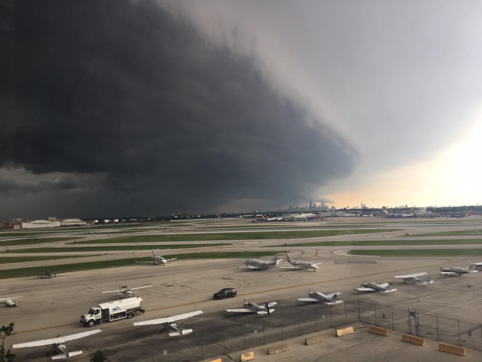
| Another view of the Gilman landspout tornado. Photo from Gale Steward. | Photo from Sam Augustyn showing the large shelf cloud spreading across the Midway airfield. | Funnel cloud in Wellington from Lesa S. |
Additional Info
The environment on Sunday, June 30th, was characterized by very warm and moist conditions with dewpoints generally in the low to mid 70s. Temperatures had warmed into the upper 80s to near 90 degrees during the late-morning and early-afternoon, although slightly cooler and drier conditions existed near the lakeshore behind a lake breeze. A complex of thunderstorms--which developed the evening before across Minnesota and North Dakota--was surging southward across southern Wisconsin late Sunday morning. As this complex encountered increasingly unstable conditions, strong winds just off the surface began to make it to the ground as widespread damaging gusts to 70 to 80 mph through the afternoon hours across the region.
 |
 |
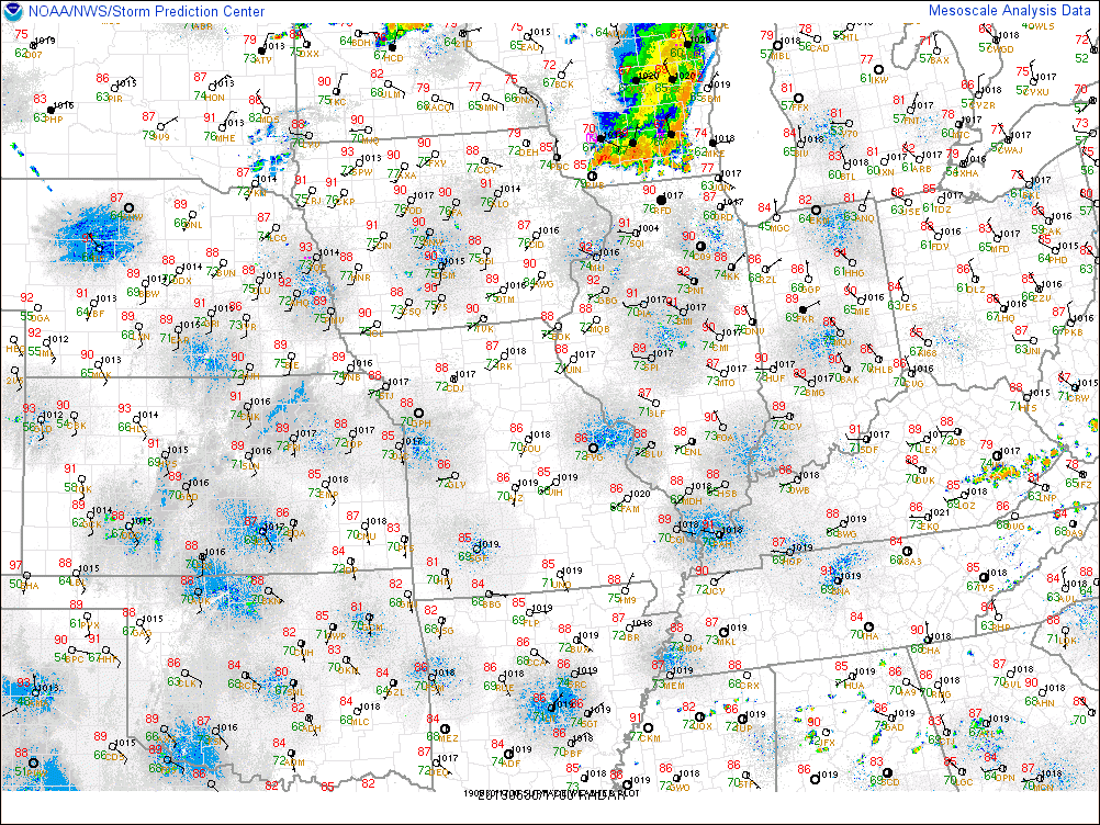 |
| Early-afternoon analysis showing very high instability across the region. | 12 PM analysis showing temperatures in the upper 80s and dewpoints in the low 70s. | Surface observations at 12 PM ahead of the thunderstorm complex. |
 |
 |
 |
| Map showing all warnings and storm reports on June 30th. | Map showing storm reports (damaging winds in blue) across the lower 48 on Sunday. | KLOT Radar loop from 11:59 AM to 5:00 PM. |
 |
Media use of NWS Web News Stories is encouraged! Please acknowledge the NWS as the source of any news information accessed from this site. Additional recaps can be found on the NWS Chicago Past Events Page |
|

