Overview
|
During the evening hours of March 28, 2020, an EF-1 tornado touched down in rural Ogle County near the town of Oregon and lifted near Stillman Valley. The tornado was on the ground for roughly 7 miles with a maximum width of ~1/4 of a mile, damaging mainly trees, power lines, outbuildings, and barns. A tornado warning was issued ~20 minutes before the tornado touched down. The storm system that produced the tornado in Ogle County also produced tornadoes across Iowa and west-central Illinois. Check out the following pages from neighboring NWS offices:
|
(taken by Jennifer Rocen Beltran, shared by Candice King (WTVO) on Twitter) |
Tornado Summary:
|
Oregon / Stillman Valley
Track Map  
|
||||||||||||||||
The Enhanced Fujita (EF) Scale classifies tornadoes into the following categories:
| EF0 Weak 65-85 mph |
EF1 Moderate 86-110 mph |
EF2 Significant 111-135 mph |
EF3 Severe 136-165 mph |
EF4 Extreme 166-200 mph |
EF5 Catastrophic 200+ mph |
 |
|||||
Photos & Video:
 |
 |
 |
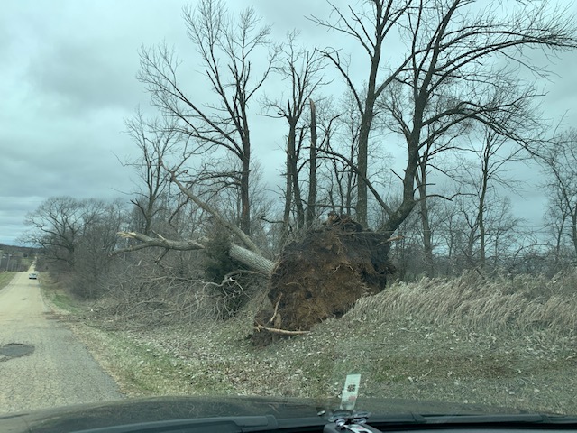
| Farming structure destroyed | Roof peeled off of a building | Uprooted tree |
Thanks to Dr. Victor Gensini, professor at Northern Illinois University, for his help during the damage survey of the tornado!
 |
| Apparent picture of the tornado taken by Jennifer Rocen Beltran, shared by Candice King (WTVO) on Twitter. |
Radar:
The thunderstorm that produced the tornado was a supercell, or a storm with a rotating updraft. Supercells are responsible for the majority of strong tornadoes across the United States, and often produce multiple tornadoes along their lifespan. In the case of March 28th, the supercell that produced the tornado near Oregon also produced two brief tornadoes earlier in west-central Illinois.
(Clockwise from top right, 0.5 degree base reflectivity, storm-relative velocity, correlation coefficient, and spectrum width)
Additional Info
 |
Media use of NWS Web News Stories is encouraged! Please acknowledge the NWS as the source of any news information accessed from this site. Additional recaps can be found on the NWS Chicago Past Events Page |
 |