|
|
(Click to enlarge loop) Visible satellite and radar loop (courtesy of the College of DuPage: https://weather.cod.edu/satrad). |
Overview
Storm Survey Information
Lake Village, Indiana Tornado
|
(click on image to enlarge) |
|
Summary: A National Weather Service storm survey determined an EF-0 tornado with peak winds near 75 mph developed near W 600 N about 2 miles west of US Route 41 where it uprooted several trees near a barn. It then tracked northeast, snapping several trees along W 700 N before crossing Route 41. Sporadic tree and limb damage was noted in a northeast path until the tornado lifted north of State Road 10 and N 75 W. |
Eastern Lake and Porter County Straight-Line Winds
|
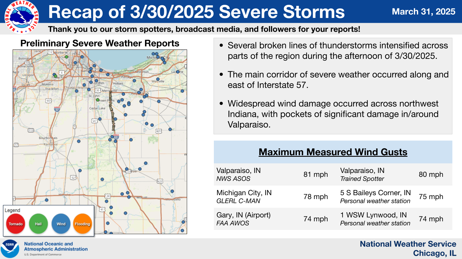
Summary: Based on an in-person damage survey, information collected from local Emergency Management officials, and reports collected via social media and from trained storm spotters, widespread damaging winds ranging from 70 to locally 90 mph impacted a wide area starting in eastern Lake County northeastward through central and northern Porter County in northwestern Indiana. Snapped and uprooted trees, downed power lines, and damage to farm buildings were noted within the wide swath of wind damage. The most intense damage occurred in and around Valparaiso, especially near and south of US-30, where several structures lost roofing materials, a semi truck was rolled onto a person leading to a fatality, and trees were snapped and felled onto homes. An 81 mph wind gust from the southwest was measured by NWS-maintained observing equipment at Porter County Regional Airport (KVPZ) before power failed, as well. Radar data depicted a signature indicative of powerful non-tornadic winds in the regions where damage was noted. |
The Enhanced Fujita (EF) Scale classifies tornadoes into the following categories:
| EF0 Weak 65-85 mph |
EF1 Moderate 86-110 mph |
EF2 Significant 111-135 mph |
EF3 Severe 136-165 mph |
EF4 Extreme 166-200 mph |
EF5 Catastrophic 200+ mph |
 |
|||||
When a tornado is known to have occurred but does not cause damage to any qualified damage indicators, or if the only damage is located in an area that is inaccessible to NWS storm survey personnel, then a tornado may be assigned the EF-Unknown (EF-U) rating.
Storm Reports
|
Preliminary Storm Report Map |
Preliminary Local Storm Report National Weather Service Chicago IL 650 PM CDT Mon Mar 31 2025 ..TIME... ...EVENT... ...CITY LOCATION... ...LAT.LON... ..DATE... ....MAG.... ..COUNTY LOCATION..ST.. ...SOURCE.... ..REMARKS.. 0133 PM Tstm Wnd Dmg 4 S Pingree Grove 42.01N 88.42W 03/30/2025 Kane IL Emergency Mngr Kane County EMA reports fence damage along Muirhead Road west of Elgin. Time estimated by radar. 0137 PM Tstm Wnd Dmg 2 ESE Pingree Grove 42.06N 88.38W 03/30/2025 Kane IL Emergency Mngr Kane County EMA reports tree blocking eastbound lanes of Highland Avenue at Coombs Road west of Elgin. Time estimated by radar. 0143 PM Tstm Wnd Dmg Sleepy Hollow 42.09N 88.31W 03/30/2025 Kane IL Public Photo shows evergreen tree uprooted near Sleepy Hollow. Relayed by broadcast media, time estimated by radar. 0146 PM Tstm Wnd Dmg 1 NNW Carpentersville 42.13N 88.26W 03/30/2025 Kane IL Emergency Mngr Kane County EMA reports power lines downed along Arrow Street and Austin Avenue in Carpentersville. Time estimated by radar. 0146 PM Tstm Wnd Dmg 1 NE Elgin 42.05N 88.27W 03/30/2025 Kane IL Emergency Mngr Kane County EMA reports broken tree branch on power lines near Fremont Street and Hill Avenue in Elgin. Time estimated by radar. 0148 PM Hail 1 SSE Algonquin 42.15N 88.28W 03/30/2025 M0.75 Inch Kane IL Public Mostly pea size hail with a few stones to penny size in southeastern Algonquin. 0152 PM Tstm Wnd Dmg 1 ENE Trout Valley 42.20N 88.24W 03/30/2025 McHenry IL Emergency Mngr Report of downed power lines that caused a fire. The cause of the downed power lines was reported to be the thunderstorm. Time and location estimated by radar. 0158 PM Tstm Wnd Gst 3 SW Crescent City 40.74N 87.90W 03/30/2025 M66 MPH Iroquois IL Public Private weather station KILGILMA8 reported 66 mph gust southwest of Crescent City. 0209 PM Hail 1 E Grayslake 42.34N 88.02W 03/30/2025 M0.70 Inch Lake IL Public Public report of hail up to 0.7 inch diameter near Grays Lake. 0217 PM Tstm Wnd Gst 3 ESE Beaverville 40.94N 87.60W 03/30/2025 M60 MPH Iroquois IL Public Private weather station reported 60 mph gust southeast of Beaverville. 0224 PM Tstm Wnd Gst 3 ESE Momence 41.14N 87.61W 03/30/2025 M62 MPH Kankakee IL Public Private weather station reported 62 mph gust southeast of Momence. 0226 PM Tstm Wnd Gst 3 SSW Fowler 40.58N 87.35W 03/30/2025 M61 MPH Benton IN Mesonet Davis weather station. 0226 PM Tstm Wnd Dmg 1 ENE Boswell 40.52N 87.37W 03/30/2025 Benton IN Emergency Mngr Photo shows metal roof panels peeled from farm outbuilding at Benton County Fairgrounds. Time estimated by radar. 0227 PM Tstm Wnd Gst 3 E Boswell 40.51N 87.32W 03/30/2025 M59 MPH Benton IN Public Private weather station reported 59 mph gust between Boswell and Oxford. 0228 PM Tornado 4 SSW Lake Village 41.08N 87.49W 03/30/2025 Newton IN NWS Storm Survey A National Weather Service storm survey determined an EF-0 tornado with peak winds near 75 mph developed near W 600 N about 2 miles west of US Route 41 where it uprooted several trees near a barn. It then tracked northeast, snapping several trees along W 700 N before crossing Route 41. Sporadic tree and limb damage was noted in a northeast path until the tornado lifted north of State Road 10 and N 75 W. 0229 PM Tstm Wnd Gst 2 WNW Brook 40.88N 87.40W 03/30/2025 M59 MPH Newton IN Public Private weather station reported 59 mph gust near Brook. 0230 PM Tstm Wnd Gst 4 SW Goodland 40.73N 87.36W 03/30/2025 M57 MPH Benton IN Public Private weather station recorded 57 mph gust between Earl park and Goodland. 0230 PM Tstm Wnd Dmg 2 W Wadena 40.69N 87.32W 03/30/2025 Benton IN Emergency Mngr Corrects previous report from 2 N Fowler. Benton County EMA reports semi tipped over on IN-55 north of Fowler near 600N Road. Time estimated by radar, location approximate. 0231 PM Hail 1 WNW Tinley Park 41.58N 87.82W 03/30/2025 M0.70 Inch Cook IL Trained Spotter Dime size hail reported in Tinley Park near 84th Avenue and 171st Street. Time estimated by radar. 0231 PM Tstm Wnd Dmg 1 E Orland Hills 41.59N 87.83W 03/30/2025 Cook IL Emergency Mngr 1.5 inch diameter tree branch broken near Chadbourn Drive and 88th Avenue in Orland Hills. Time estimated by radar. 0234 PM Hail 2 SE St. John 41.42N 87.44W 03/30/2025 E0.75 Inch Lake IN Public Relayed via mping. 0235 PM Tstm Wnd Gst 5 ESE Wadena 40.65N 87.19W 03/30/2025 M62 MPH Benton IN Public Private weather station reported 62 mph gust east of Fowler. 0236 PM Tstm Wnd Dmg 1 WNW Roselawn 41.15N 87.33W 03/30/2025 Newton IN Trained Spotter Trained spotter reports numerous trees uprooted and branches broken along IN-55 north of IN-10. Time estimated by radar, location approximate. 0237 PM Tstm Wnd Dmg 1 E Thayer 41.17N 87.31W 03/30/2025 Newton IN Trained Spotter Trained spotter reports 12 inch diameter tree downed near county 400 E and county 1200 N. Time estimated by radar. 0238 PM Tstm Wnd Gst 2 NNW Remington 40.79N 87.17W 03/30/2025 M63 MPH Jasper IN Public Private weather station reported 63 mph gust north of Remington. 0238 PM Tstm Wnd Dmg 2 E Roselawn 41.14N 87.28W 03/30/2025 Newton IN Public Trained spotter reports bent power poles in Roselawn along IN-10 3 miles east of IN-55. Time estimated by radar, location approximate. 0239 PM Tstm Wnd Gst Remington 40.76N 87.16W 03/30/2025 M62 MPH Jasper IN Public Private weather station reported 62 mph gust in Remington. Multiple other private weather stations reported gusts 55-60 mph in vicinity. 0239 PM Tstm Wnd Dmg Steger 41.48N 87.63W 03/30/2025 Cook IL Emergency Mngr Roof blown off building near Sauk Trail and Holeman Avenue in Steger. Time estimated by radar. 0239 PM Tstm Wnd Dmg Lowell 41.29N 87.42W 03/30/2025 Lake IN Emergency Mngr Lake County EMA reports power poles snapped in Lowell. Time estimated by radar, location approximate. 0240 PM Hail 1 SW Evergreen Park 41.71N 87.72W 03/30/2025 M0.75 Inch Cook IL Public Relayed via mping. 0240 PM Tstm Wnd Dmg 1 SSW West Pullman - Ch 41.67N 87.64W 03/30/2025 Cook IL Public Public report of small tree branches downed near 12th Place and Parnell Avenue in West Pullman Community area of Chicago. Time estimated by radar. 0244 PM Tstm Wnd Dmg 1 E Pullman - Chicago 41.71N 87.58W 03/30/2025 Cook IL Public A few scattered reports of tree branches downed in the East Side, Calumet Heights, Roseland, Burnside, Pullman, South Deering, and Riverdale community areas of Chicago. Relayed by Chicago311, time estimated by radar. 0245 PM Tstm Wnd Gst 1 WSW Lynwood 41.52N 87.56W 03/30/2025 M74 MPH Cook IL Public Private weather station reported reported 74 mph gust near Ford Heights. 0245 PM Tstm Wnd Dmg 4 WSW Hebron 41.29N 87.28W 03/30/2025 Lake IN Trained Spotter Photo shows construction trailer overturned and broken into pieces along IN-2 near Clay Street east of Lowell. Time estimated by radar. 0246 PM Tstm Wnd Gst 1 ESE Hebron 41.32N 87.19W 03/30/2025 M61 MPH Porter IN Mesonet Measured at Davis station WWTP. 0248 PM Tstm Wnd Gst 5 E Rensselaer 40.95N 87.06W 03/30/2025 M62 MPH Jasper IN Public Davis station measurement. 0248 PM Tstm Wnd Dmg 1 SW Dyer 41.49N 87.52W 03/30/2025 Lake IN Emergency Mngr Lake County EMA reports power poles snapped in Dyer. Time estimated by radar, location approximate. 0249 PM Tstm Wnd Gst 3 SSW Stoutsburg 41.15N 87.14W 03/30/2025 M56 MPH Jasper IN Public Private weather station reported 56 mph gust southeast of DeMotte. 0249 PM Marine Tstm Wind 1 SE South Chicago 41.73N 87.54W 03/30/2025 M52 MPH Cook IL C-Man Station Buoy station CMTI2 Calumet Harbor. 0250 PM Tstm Wnd Gst 4 WNW Remington 40.78N 87.22W 03/30/2025 M71 MPH Jasper IN Public Private weather station reported 71 mph gust between Goodland and Remington. 0250 PM Tstm Wnd Dmg Highland 41.55N 87.45W 03/30/2025 Lake IN Emergency Mngr Lake County EMA reports tree or large branch on house in Highland. Time estimated by radar, location approximate. 0250 PM Tstm Wnd Dmg 2 NNW Hammond 41.61N 87.51W 03/30/2025 Lake IN Emergency Mngr Lake County EMA reports power poles snapped in Hammond. Time estimated by radar, location approximate. 0250 PM Tstm Wnd Dmg 1 SE Hammond 41.58N 87.49W 03/30/2025 Lake IN Public Report of several trees down some over 2 inches in diameter. Time estimated from radar. 0251 PM Tstm Wnd Gst 5 S Baileys Corner 40.99N 87.01W 03/30/2025 M75 MPH Jasper IN Mesonet Davis station. 0251 PM Tstm Wnd Gst 1 SSE Munster 41.54N 87.50W 03/30/2025 M60 MPH Lake IN Public Private weather station reported 60 mph gust in Munster. 0251 PM Tstm Wnd Dmg 1 W Lakes of the Four S 41.41N 87.25W 03/30/2025 Lake IN Broadcast Media Photo shows shingle damage to house in Latitude subdivision west of Lake of the Four Seasons in Winfield. Time estimated by radar. 0252 PM Tstm Wnd Dmg 2 SSE Lakes of the Four 41.38N 87.20W 03/30/2025 Porter IN Emergency Mngr Tree branches broken and barn damaged near IN-2 and county 350S Road. Time estimated by radar. 0253 PM Tstm Wnd Gst 1 NW East Chicago 41.65N 87.47W 03/30/2025 M60 MPH Lake IN Mesonet WxFlow station Cline Avenue Bridge. 0253 PM Tstm Wnd Dmg 3 ESE Lakes of the Four 41.40N 87.16W 03/30/2025 Porter IN Public Trained spotter reports 4 power poles snapped and downed power lines near Boone Grove High School southwest of Valparaiso. Time estimated by radar. 0253 PM Tstm Wnd Dmg 2 WSW East Chicago 41.63N 87.50W 03/30/2025 Lake IN Emergency Mngr Lake County EMA reports power poles snapped in East Chicago. Time estimated by radar, location approximate. 0253 PM Tstm Wnd Dmg 3 NW Boone Grove 41.39N 87.16W 03/30/2025 Porter IN Trained Spotter Trained spotter reports large branches broken near county 300S Road and county 500W Road southwest of Valparaiso. Time estimated by radar. 0253 PM Tstm Wnd Dmg 1 NE Lakes of the Four 41.42N 87.22W 03/30/2025 Porter IN Public Public report of shingle damage near Lake of the Four Seasons. Time estimated by radar. 0255 PM Tstm Wnd Gst Gary Airport 41.62N 87.41W 03/30/2025 M74 MPH Lake IN AWOS Gary Airport GYY reported 74 mph gust. Winds sustained at 48 mph for 10 minutes. 0255 PM Tstm Wnd Gst 2 WNW Rensselaer 40.95N 87.18W 03/30/2025 M59 MPH Jasper IN AWOS Corrects previous report from 2 WNW Rensselaer. Rensselaer Jasper County Airport RZL AWOS reported 59 mph gust. 0255 PM Tstm Wnd Dmg Gary 41.59N 87.35W 03/30/2025 Lake IN Emergency Mngr Lake County EMA reports power poles snapped in Gary. Time estimated by radar, location approximate. 0255 PM Tstm Wnd Dmg Kouts 41.32N 87.03W 03/30/2025 Porter IN Law Enforcement Power lines downed in Kouts. Time estimated by radar, location approximate. 0256 PM Tstm Wnd Gst 3 N Lakes of the Four S 41.46N 87.21W 03/30/2025 M75 MPH Porter IN Public Private weather station reported 75 mph gust northeast of Winfield. 0256 PM Tstm Wnd Dmg 5 S Valparaiso 41.41N 87.05W 03/30/2025 Porter IN Trained Spotter Photo shows metal roof panels peeled from farm outbuilding along county 75E Road south of Valparaiso. Time estimated by radar. 0258 PM Marine Tstm Wind 3 NE Navy Pier 41.92N 87.57W 03/30/2025 M50 MPH LMZ741 IL C-Man Station Measured at the Harrison-Dever crib. 0300 PM Tstm Wnd Gst 4 ESE Valparaiso 41.45N 87.00W 03/30/2025 M81 MPH Porter IN AWOS Valparaiso Porter County Airport VPZ AWOS reported 81 mph gust prior to data outage. 0300 PM Tstm Wnd Gst Valparaiso 41.47N 87.07W 03/30/2025 M80 MPH Porter IN Public Trained spotter reported 80 mph gust in Valparaiso. 0300 PM Tstm Wnd Gst 4 SSE Kouts 41.26N 87.00W 03/30/2025 M63 MPH Porter IN Trained Spotter Trained weather spotter reported 63 mph gust on handheld anemometer on county 1200S southeast of Kouts. Time estimated by radar. 0300 PM Hail 4 SSE Kouts 41.26N 87.00W 03/30/2025 M0.88 Inch Porter IN Public Trained spotter reported nickel size hail on county 1200S Road southeast of Kouts. Time estimated by radar. 0300 PM Tstm Wnd Dmg 3 SE Valparaiso 41.44N 87.02W 03/30/2025 Porter IN Emergency Mngr *** 1 FATAL *** A semi truck rolled onto a person, leading to a fatality. 0301 PM Tstm Wnd Dmg 1 NE Valparaiso 41.49N 87.05W 03/30/2025 Porter IN Public Public report of broken tree branches in northern Valparaiso. Time estimated by radar. 0302 PM Tstm Wnd Gst 4 NNE Teft 41.25N 86.95W 03/30/2025 M64 MPH Porter IN Public Private weather station reported 64 mph gust southeast of Kouts. 0304 PM Tstm Wnd Gst 2 NNE Kouts 41.34N 87.02W 03/30/2025 M70 MPH Porter IN Public Private weather station KINKOUTS6 reported 70 mph gust north of Kouts. 0304 PM Tstm Wnd Dmg 2 ENE South Haven 41.55N 87.11W 03/30/2025 Porter IN Trained Spotter Trained spotter reported multiple 6 inch diameter branches broken along US-6 between Porter and Valparaiso. Time estimated by radar, location approximate. 0324 PM Marine Tstm Wind 3 NE Beverly Shores 41.73N 86.94W 03/30/2025 M78 MPH LMZ745 IN C-Man Station Measured at the Michigan City GLERL site. |
 |
Media use of NWS Web News Stories is encouraged! Please acknowledge the NWS as the source of any news information accessed from this site. Additional event recaps can be found on the NWS Chicago Past Events Page |
|


![[Location] Tornado Summary Graphic](/images/lot/pastevents/2025/03_30_Severe/LakeVillageTornado.png)
