 |
Fast Facts
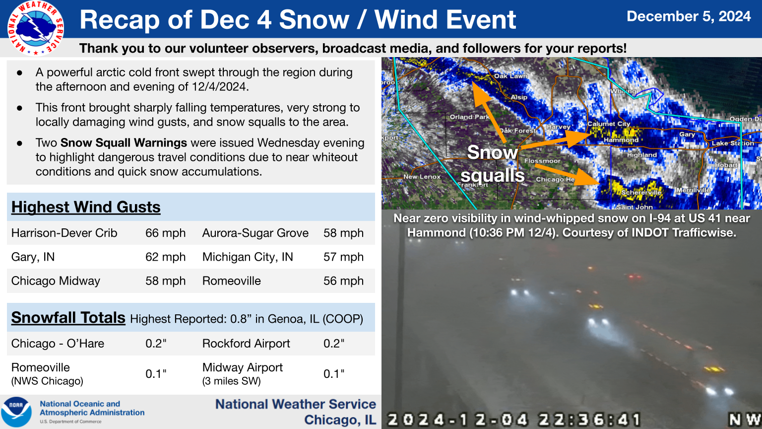
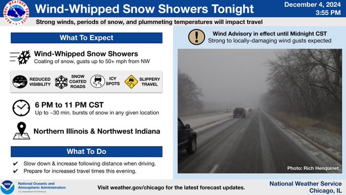
A powerful arctic cold front moved through northern Illinois and northwest Indiana during the afternoon and evening of Wednesday, December 4th, 2024.
The front resulted quickly falling temperatures, strong to locally damaging winds, snow squalls, and sub-zero wind chills by early Thursday morning, December 5th.

|
|
|
Storm Reports
Interactive Map of Recent Local Storm Reports
Preliminary Local Storm Report...Summary
National Weather Service Chicago IL
426 PM CST Thu Dec 5 2024

..TIME...   ...EVENT...      ...CITY LOCATION...     ...LAT.LON...
..DATE...   ....MAG....      ..COUNTY LOCATION..ST.. ...SOURCE....
            ..REMARKS..

0536 PM     Non-Tstm Wnd Dmg 1 WNW Bull Valley       42.32N 88.37W
12/04/2024                   McHenry            IL   Broadcast Media

            Tree down blocking Bull Valley Rd.

0551 PM     Non-Tstm Wnd Gst Midway Airport          41.79N 87.75W
12/04/2024  M58 MPH          Cook               IL   Official NWS Obs

            Corrects previous non-tstm wnd gst report
            from Midway Airport.

0551 PM     Non-Tstm Wnd Gst 3 SW Midway Airport     41.74N 87.78W
12/04/2024  M60 MPH          Cook               IL   CO-OP Observer


0600 PM     Non-Tstm Wnd Dmg 1 NNW Douglas - Chicago 41.85N 87.62W
12/04/2024                   Cook               IL   NWS Employee

            Roof damage to building with considerable
            debris scattered downstream of the building.

0603 PM     Non-Tstm Wnd Gst 2 WNW Sugar Grove       41.77N 88.48W
12/04/2024  M58 MPH          Kane               IL   ASOS


0620 PM     Non-Tstm Wnd Gst Gary Airport            41.62N 87.42W
12/04/2024  M62 MPH          Lake               IN   AWOS


0623 PM     Non-Tstm Wnd Dmg 2 E Woodstock           42.32N 88.41W
12/04/2024                   McHenry            IL   Broadcast Media

            Large branch down onto a vehicle with person
            trapped in vehicle.

0630 PM     Non-Tstm Wnd Dmg 4 WNW Bolingbrook       41.71N 88.14W
12/04/2024                   Will               IL   NWS Employee

            Large part of a tree down blocking Knoch
            Knoll Rd near Knoch Knoll Park in
            Naperville.

0930 PM     Non-Tstm Wnd Dmg 5 SW Sibley             40.53N 88.44W
12/04/2024                   Ford               IL   Emergency Mngr

            Power lines down across E 900 N and N 100 E
            rd between Gibson City and Sibley. FD on
            scene to shut the road down. Report received
            at 10:10 PM.

0953 PM     Snow Squall      1 S Hanover Park        41.99N 88.15W
12/04/2024                   Cook               IL   Emergency Mngr

            EM reports visibility under 500 feet for
            approximately 20 minutes with roads
            completely covered by snow.

1035 PM     Snow Squall      Gary Airport            41.61N 87.41W
12/04/2024                   Lake               IN   AWOS

            Gary AWOS reports 1/4 mile visibility and
            winds gusting 30 to 40 mph. Area webcams
            show rapid snow accumulations on nearby
            interstates.

1035 PM     Snow Squall      1 NNE Lynwood           41.54N 87.53W
12/04/2024                   Cook               IL   AWOS

            Lansing AWOS reported 1/4 mile visibility
            and a 28 mph gust. Area webcams show rapid
            accumulations on interstates.


&&

$$
Peak Winds
Public Information Statement
National Weather Service Chicago IL
248 AM CST Thu Dec 5 2024

...HIGHEST WIND REPORTS FROM WEDNESDAY...

Location                     Speed     Time/Date       Provider
Harrison-Dever Crib          66 MPH    0620 PM 12/04   NDBC
Gary Airport                 62 MPH    0620 PM 12/04   AWOS
Chicago Midway               58 MPH    0626 PM 12/04   ASOS
Aurora-Sugar Grove           58 MPH    0630 PM 12/04   ASOS
Ellwood                      59 MPH    0618 PM 12/04   MESOWEST
2 WNW Michigan City          57 MPH    0930 PM 12/04   NDBC
Romeoville - Lewis Airport   56 MPH    0553 PM 12/04   AWOS
Harvard 6 NW (UP Rail)       56 MPH    0427 PM 12/04   MESOWEST
Morris Airport               55 MPH    0635 PM 12/04   AWOS
West Chicago - DuPage Arpt.  55 MPH    0604 PM 12/04   ASOS
Valparaiso Airport           54 MPH    0758 PM 12/04   ASOS
Elmhurst (UP Rail)           53 MPH    0541 PM 12/04   MESOWEST
Calumet Harbor               52 MPH    0618 AM 12/04   NOS-NWLON
Rockford Airport             52 MPH    0328 PM 12/04   ASOS
Montrose Beach Light         52 MPH    0636 PM 12/04   WXFLOW
DeKalb Airport               51 MPH    0515 PM 12/04   AWOS
Chicago OHare                51 MPH    0613 PM 12/04   ASOS
Waukegan Airport             51 MPH    0500 PM 12/04   ASOS
Wheeling - Chicago Exec. Arp 50 MPH    0510 PM 12/04   ASOS
Dixon2                       50 MPH    0510 PM 12/04   MESOWEST
Kankakee Airport             48 MPH    0735 PM 12/04   AWOS
Rochelle Airport             48 MPH    0715 PM 12/04   AWOS
Peru Airport                 48 MPH    0835 PM 12/04   AWOS
Dixon Airport                47 MPH    0519 PM 12/04   AWOS
Braceville 2 SW (UP Rail)    46 MPH    0659 PM 12/04   MESOWEST
Lansing Airport              45 MPH    0715 PM 12/04   AWOS
Rensselaer Airport           43 MPH    0715 PM 12/04   AWOS
Rochelle 4 WSW (UP Rail)     43 MPH    0715 PM 12/04   MESOWEST
Pontiac 5 SSW (UP Rail)      42 MPH    0910 PM 12/04   MESOWEST
Geneva 3 W (UP Rail)         42 MPH    0557 PM 12/04   MESOWEST
Papineau 2 N (UP Rail)       41 MPH    0825 PM 12/04   MESOWEST
Schaumburg Airport           40 MPH    0615 PM 12/04   AWOS
Claytonville 2 ENE (UP Rail) 40 MPH    1147 PM 12/04   MESOWEST
Mount Prospect (UP Rail)     40 MPH    0459 PM 12/04   MESOWEST
Joliet Airport               38 MPH    0615 PM 12/04   AWOS
Cary (UP Rail)               38 MPH    0535 PM 12/04   MESOWEST
ANTIOCH                      37 MPH    0525 PM 12/04   CWOP
Frankfort                    37 MPH    0735 PM 12/04   URBANET
Highland Park (UP Rail)      37 MPH    1001 PM 12/04   MESOWEST
Schaumburg                   36 MPH    0555 PM 12/04   DAVIS
Chicago - Albany Park (UP Ra 36 MPH    0714 PM 12/04   MESOWEST
Union Hill                   34 MPH    1100 PM 12/04   CWOP
Glenview 2 WNW (UP Rail)     34 MPH    0732 PM 12/04   MESOWEST
Burns Harbor Light           33 MPH    0640 PM 12/04   NDBC
Momence (UP Rail)            31 MPH    0645 PM 12/04   MESOWEST
Valparaiso                   30 MPH    0632 PM 12/04   CWOP

Observations are collected from a variety of sources with varying
equipment and exposures. We thank all volunteer weather observers
for their dedication. Not all data listed are considered official.

$$
Wind Chills on the Morning of December 5th
Public Information Statement
National Weather Service Chicago IL
1034 AM CST Thu Dec 5 2024

...MINIMUM WIND CHILL REPORTS AS OF 10 AM THIS MORNING...

Location                     WC Temp.  Time/Date       Provider
Schaumburg                   -12 F     0525 AM 12/05   DAVIS
Claytonville 2 ENE (UP Rail) -11 F     0403 AM 12/05   MESOWEST
DeKalb Airport               -11 F     0735 AM 12/05   AWOS
Deerfield                    -11 F     0545 AM 12/05   AWS
Romeoville - Lewis Airport   -10 F     0535 AM 12/05   AWOS
Morris Airport                -9 F     0655 AM 12/05   AWOS
Grant - White ES Forest Park  -9 F     0540 AM 12/05   URBANET
Rochelle Airport              -9 F     0635 AM 12/05   AWOS
Frankfort                     -9 F     0539 AM 12/05   URBANET
Gary Airport                  -8 F     0415 AM 12/05   AWOS
West Chicago - DuPage Arpt.   -8 F     0652 AM 12/05   ASOS
Dixon Airport                 -8 F     0835 AM 12/05   AWOS
Earlville                     -8 F     0625 AM 12/05   DAVIS
Rockford Airport              -8 F     0654 AM 12/05   ASOS
Chicago - McKinley Park       -8 F     0555 AM 12/05   AWS
Cary (UP Rail)                -8 F     0528 AM 12/05   MESOWEST
Calumet Harbor                -7 F     0700 AM 12/05   NOS-NWLON
Visitation School Elmhurst,   -7 F     0620 AM 12/05   URBANET
Rensselaer Airport            -7 F     0755 AM 12/05   AWOS
Schaumburg Airport            -7 F     0535 AM 12/05   AWOS
Chicago OHare                 -6 F     0151 AM 12/05   ASOS
Wheeling - Chicago Exec. Arp  -6 F     0552 AM 12/05   ASOS
Waukegan Airport              -6 F     0451 AM 12/05   ASOS
Valparaiso Airport            -6 F     0554 AM 12/05   ASOS
Lansing Airport               -6 F     0555 AM 12/05   AWOS
ANTIOCH                       -6 F     0530 AM 12/05   CWOP
2 W Rolling Meadows           -6 F     0445 AM 12/05   DAVIS
1 WSW Crystal Lawns           -6 F     0215 AM 12/05   AWS
Earlville                     -5 F     0825 AM 12/05   DAVIS
Kankakee Airport              -5 F     0735 AM 12/05   AWOS
Clarendon Hills               -5 F     0658 AM 12/05   AWS
Hazel Crest                   -5 F     0219 AM 12/05   AWS
Peru Airport                  -5 F     0635 AM 12/05   AWOS
Elburn                        -5 F     0755 AM 12/05   AWS
Marengo                       -5 F     0715 AM 12/05   DAVIS
1 ENE Mundelein               -5 F     0508 AM 12/05   AWS
1 ESE Deerfield               -5 F     0530 AM 12/05   AWS
Chicago Midway                -4 F     0553 AM 12/05   ASOS
Buffalo Grove 2 NNE           -4 F     0623 AM 12/05   AWS
&&

Observations are collected from a variety of sources with varying
equipment and exposures. We thank all volunteer weather observers
for their dedication. Not all data listed are considered official.

$$
Meteorology
|
Regional radar loop just prior to the issuance of the snow squall warnings. |
NWS infographics regarding the science behind snow squalls. The keys to remember are 1.) a strong cold front or upper disturbance, 2.) instability, and 3.) thermal profile within the clouds supporting efficient snowfall. |
 |
|
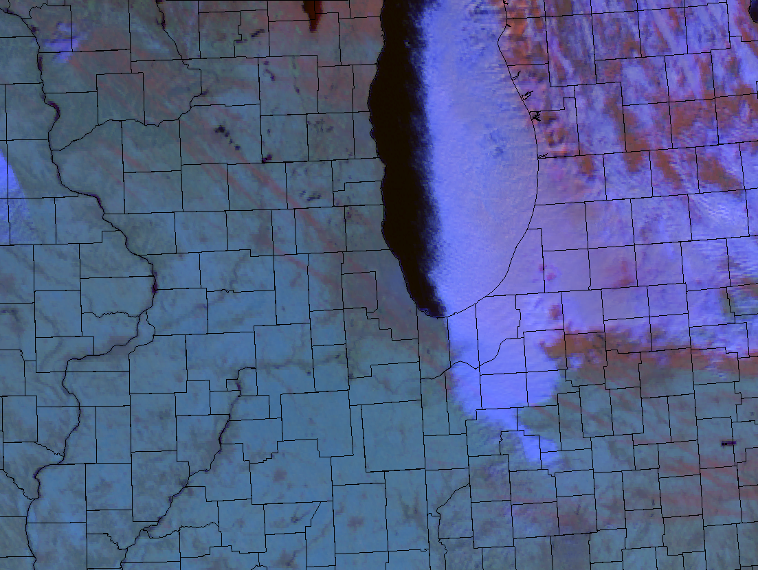
| GOES-East Day Snow Fog RGB on morning of 12/5 showing streaks of snow from Wednesday evening's squalls in red shading (clouds are white). |
Videos & Links
Videos
|
|
|
|
Snow band moving across interstate 90/94 near Hammond, IN.
Courtesy of INDOT.
Video of heavy snow band moving through Joliet (west side) around 11:30pm late Wednesday evening. Courtesy of the Joliet Weather Center on X. |
Dashcam video of snow squall passing over I-355 Wednesday evening. Video from NWS Chicago Meteorologist. |
Links
 |
Media use of NWS Web News Stories is encouraged! Additional recaps can be found on the NWS Chicago Past Events Page. |
 |