
Severe thunderstorms will remain possible in the Mid-Atlantic through Tuesday. Severe thunderstorms and heavy rain will also be possible in the central/southern Plains on Tuesday and Wednesday. Hazardous heat will linger across the southern U.S. and build across the West through mid-week. Hot and dry weather will create Elevated to Critical fire weather conditions in the Four Corners Region. Read More >
|
|
Overview
Summary:
 |
|
|
| The NWS Storm Prediction Center's Day 1 Severe Weather Outlook, issued at 1300Z/8 AM CDT the morning before the derecho | The NWS Storm Prediction Center's updated Day 1 Severe Weather Outlook, issued at 2000Z/3 PM CDT, just a few hours before the derecho developed | The Tornado Watch that was issued for the area at 7 PM CDT on July 15, 2024 |
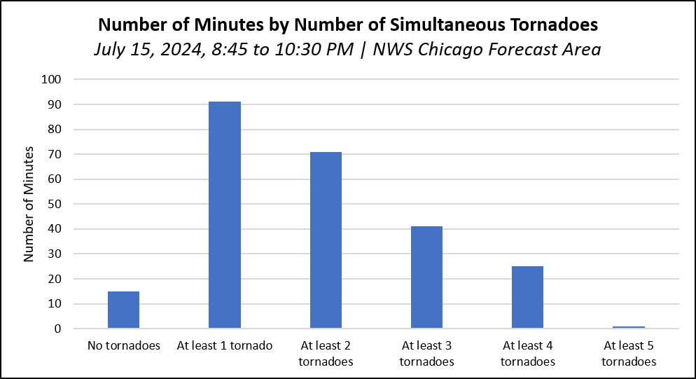
By the Numbers:
The derecho produced a remarkable number of tornadoes in the region. Below are a few statistics that provide some context for just how prolific the derecho was with tornado production. Official NWS tornado records date back to 1950.
 |
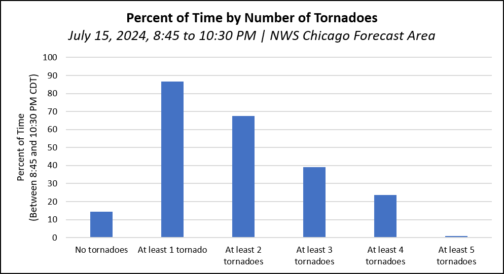 |
| The number of minutes by number of simultaneous tornadoes within the NWS Chicago forecast area between 8:25 and 10:30 PM CDT, July 15, 2024. | The percent of total time (1 hour 45 minutes) by number of simultaneous tornadoes within the NWS Chicago forecast area between 8:25 and 10:30 PM CDT, July 15, 2024 |
What is a Derecho?
 |
| Understanding a damaging wind thunderstorm complex |
Tornadoes
|
|
|
Downloadable KMZ File with All Damage Survey Findings Downloadable Shapefile with All Damage Survey Findings
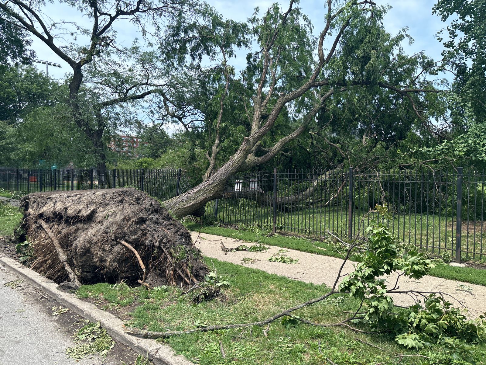
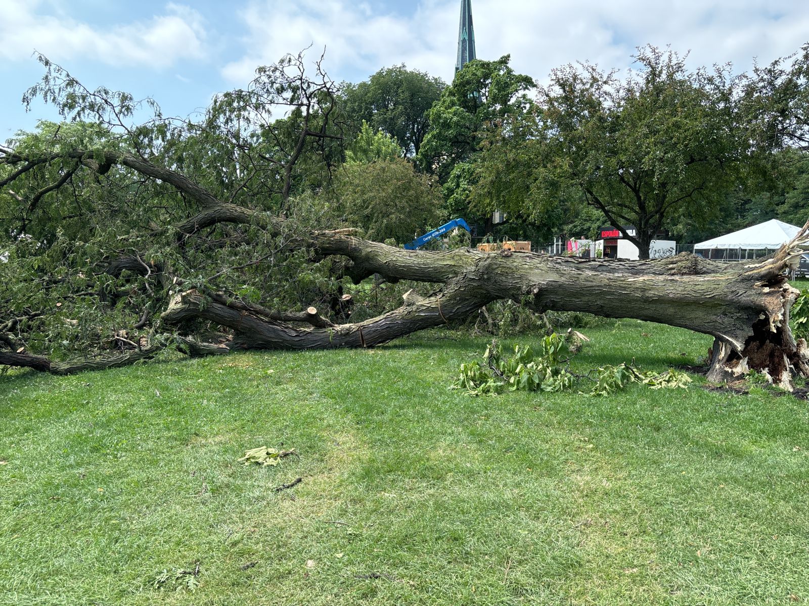
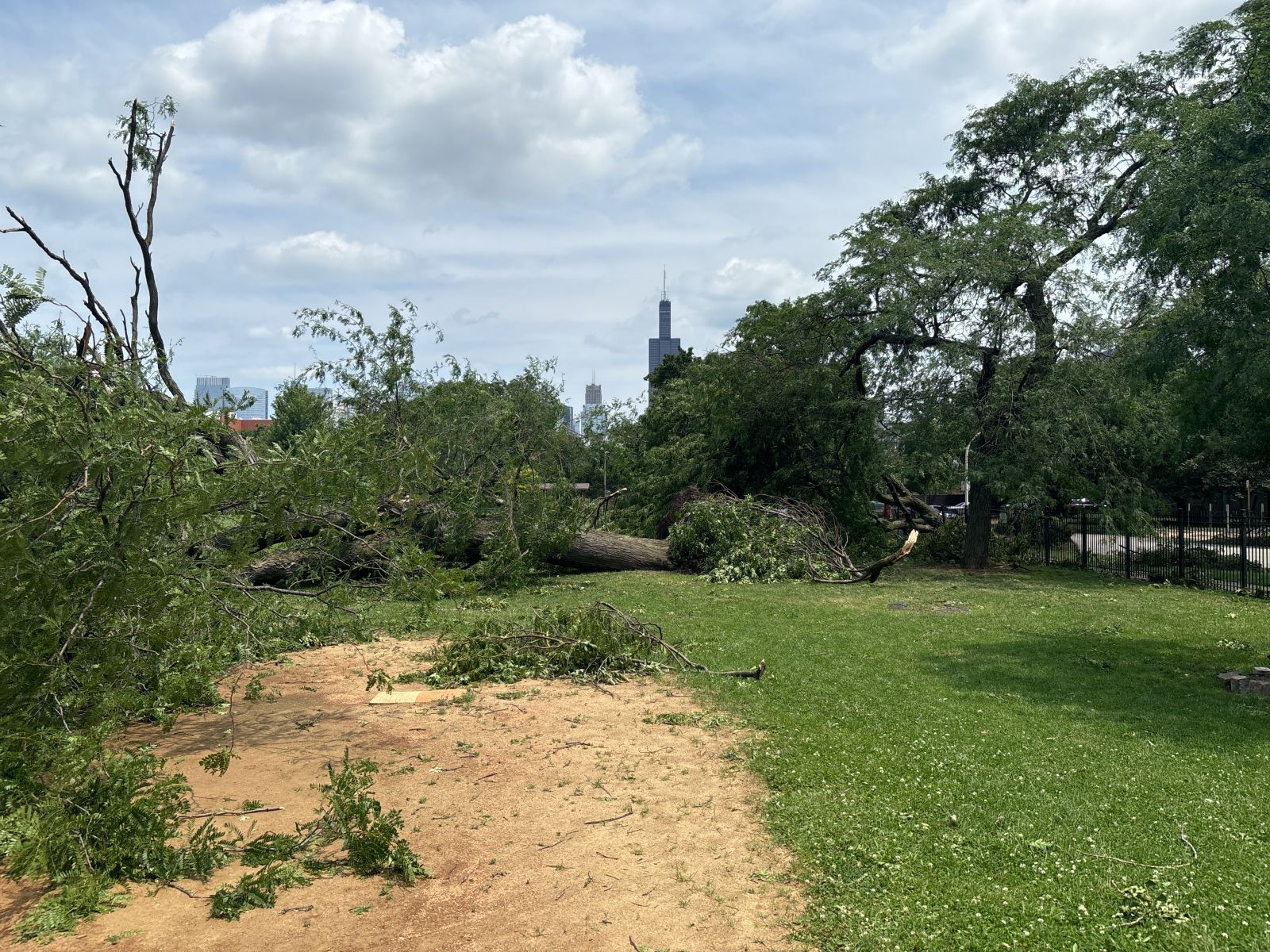
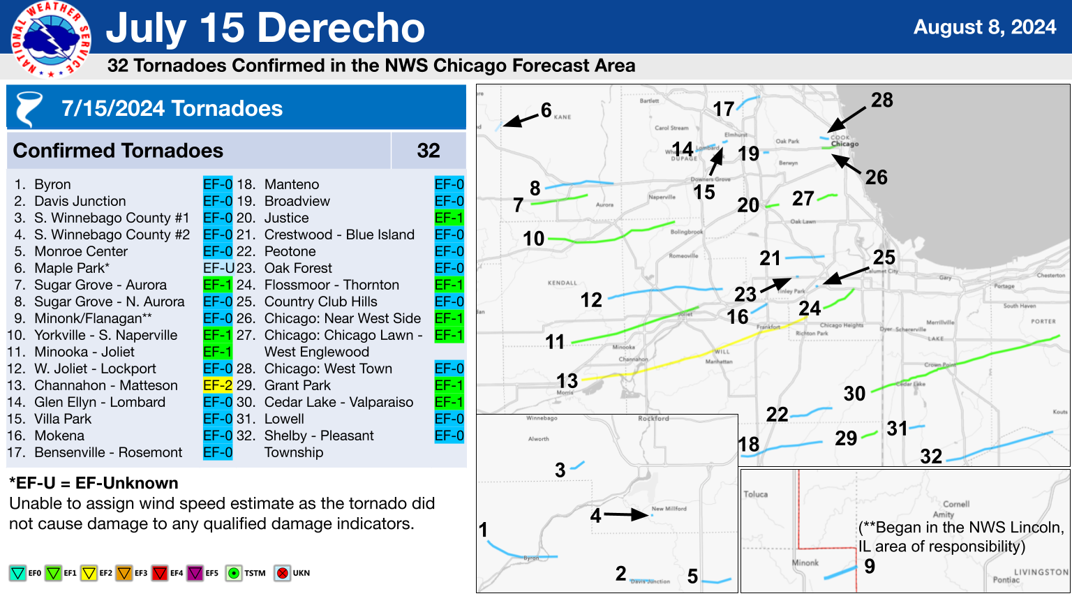
Below is a summary of all 32 of the confirmed tornadoes in the NWS Chicago forecast area from this severe weather event. An interactive map with all of this information can be found on our Damage Assessment Toolkit Viewer website (to see the data from this event, make sure that the date range in the top right corner includes this event's date). Instructions for how to download survey data (KMZ files and shapefiles) are available here. |
Note: Rotation in squall lines can be finicky with rapid strengthening and weakening on the order of seconds in close proximity to non-tornadic winds. Sometimes, a tornado starts to develop but fails, causing a slight uptick in damage and even a curl to the wind. It's difficult to say when this process "officially" becomes tornadic. As a result, confirming tornadoes produced by lines of storms can be an arduous process.
During our survey process, which took weeks to complete, we looked at well over 100 miles of damage produced by this storm in-person. In addition, we assessed information shared with us from our trusted emergency management partners as well as members of the public, and analyzed various sources of high-resolution satellite imagery. Through this process, we tried our very best to determine if, when, and where tornadoes occurred. While we try our very best to catalog the cause of damage, it is possible there were brief tornadoes in the areas of non-tornadic winds that we simply could not survey or did not find enough evidence to make a definitive determination. Regardless of whether winds were rotating or not at any given location, the July 15, 2024 derecho caused widespread wind damage across a large part of our area.
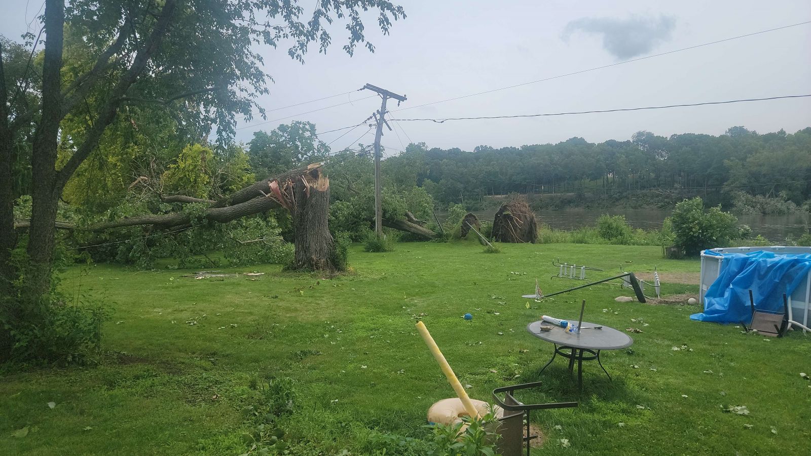
1.) Byron, IL Tornado
|
(click on image to enlarge) |
|
Summary: High-resolution satellite imagery indicates that a tornado began in a corn field west of Byron before tracking southeast into Byron. The tornado remained at EF-0 intensity as it tracked through Byron, producing tree damage across town and blowing roofing material off of a car wash before ending just east of the Rock River. |
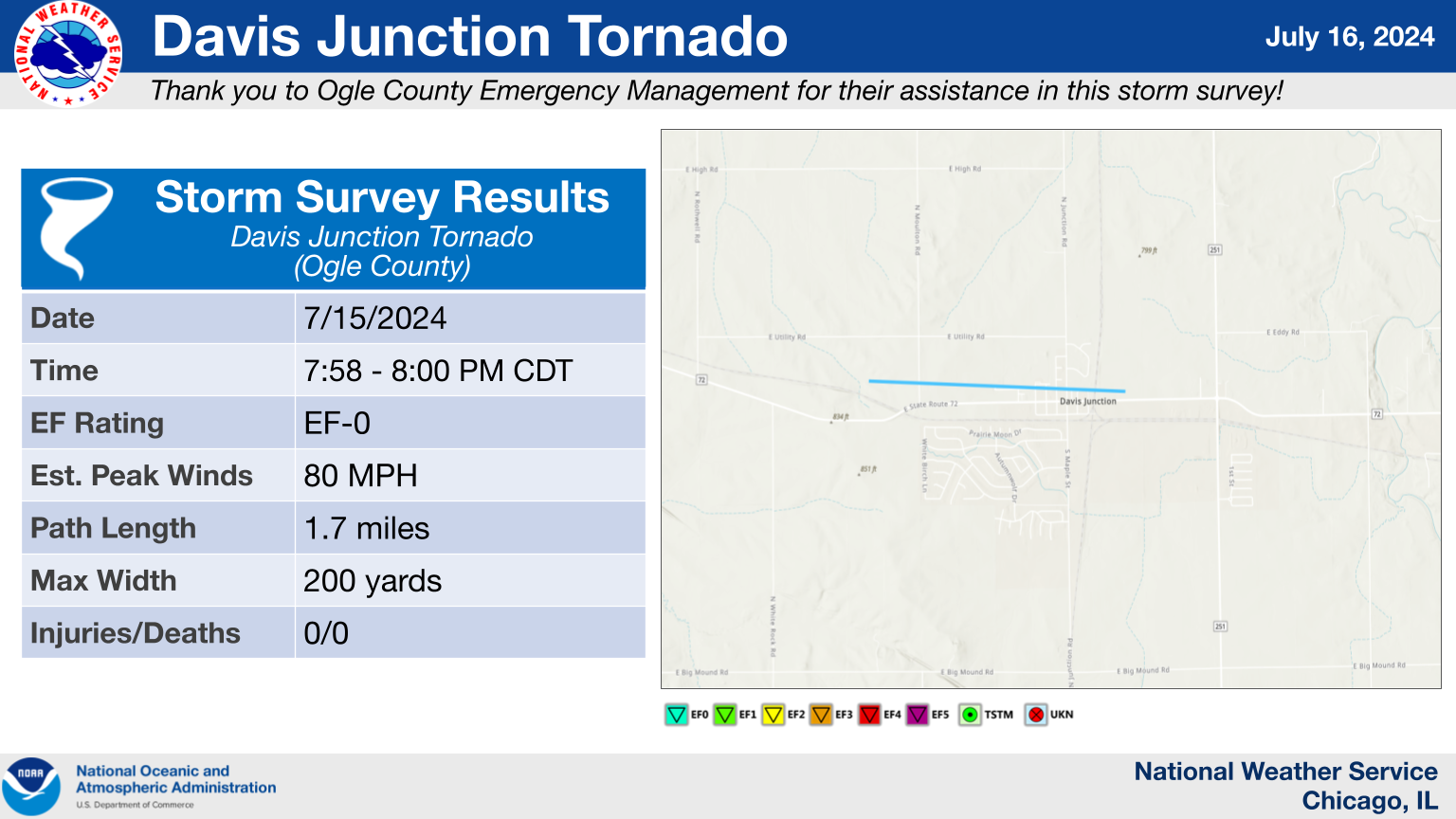
2.) Davis Junction, IL Tornado
|
(click on image to enlarge) |
|
Summary: A brief EF-0 tornado tracked through the north side of Davis Junction, producing a corridor of tree damage before dissipating just east of town. |
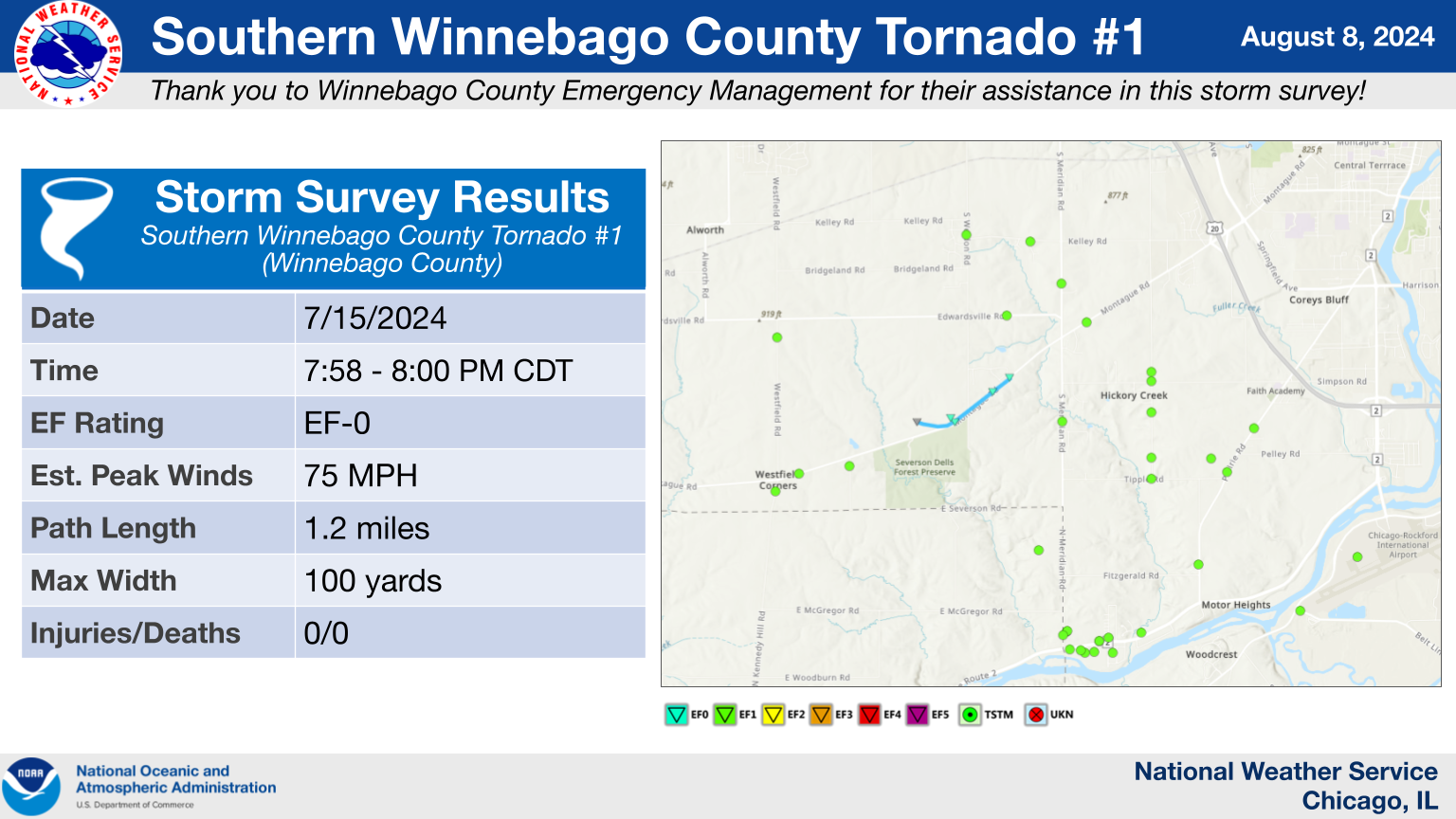
3.) Southern Winnebago County, IL Tornado #1
|
(click on image to enlarge) |
|
Summary: An EF-0 tornado tracked for approximately 1.2 miles along Montague Road southwest of Rockford, causing damage to corn crops, trees, and power lines. |
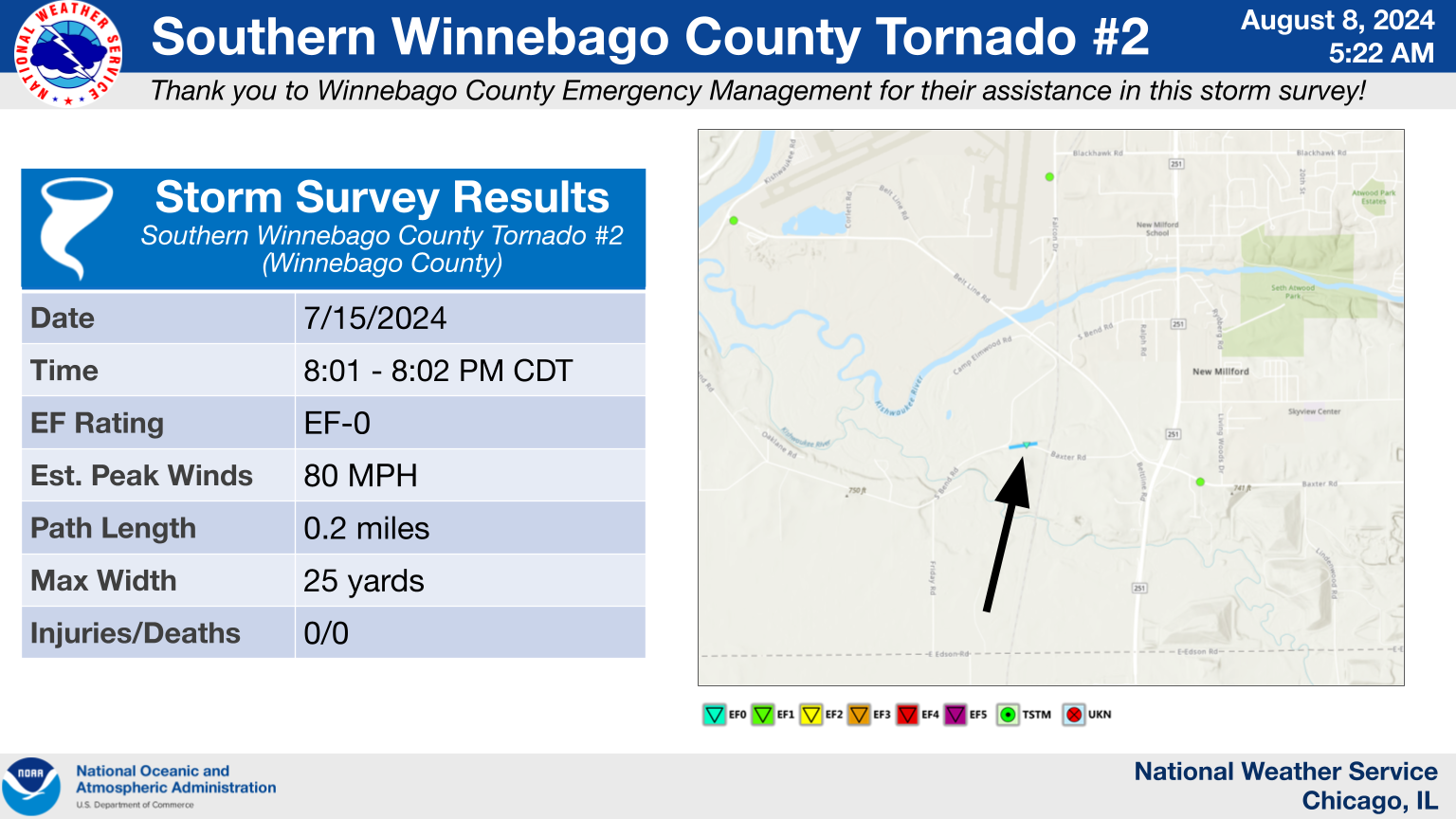
4.) Southern Winnebago County, IL Tornado #2
|
(click on image to enlarge) |
|
Summary: Photos and videos were taken of a funnel cloud looking south-southwest from the east side of Rockford and looking west from near I-39 and Baxter Road. Drone footage taken by the Winnebago County Emergency Management Agency revealed a corridor of tree damage along Baxter Road west of State Route 251, roughly in line with where the funnel cloud was observed and where a mesovortex was sampled by the KLOT radar. In this narrow corridor, trees and tree limbs were downed in various directions and onto power lines, suggesting that the funnel cloud was briefly in contact with the ground here. |
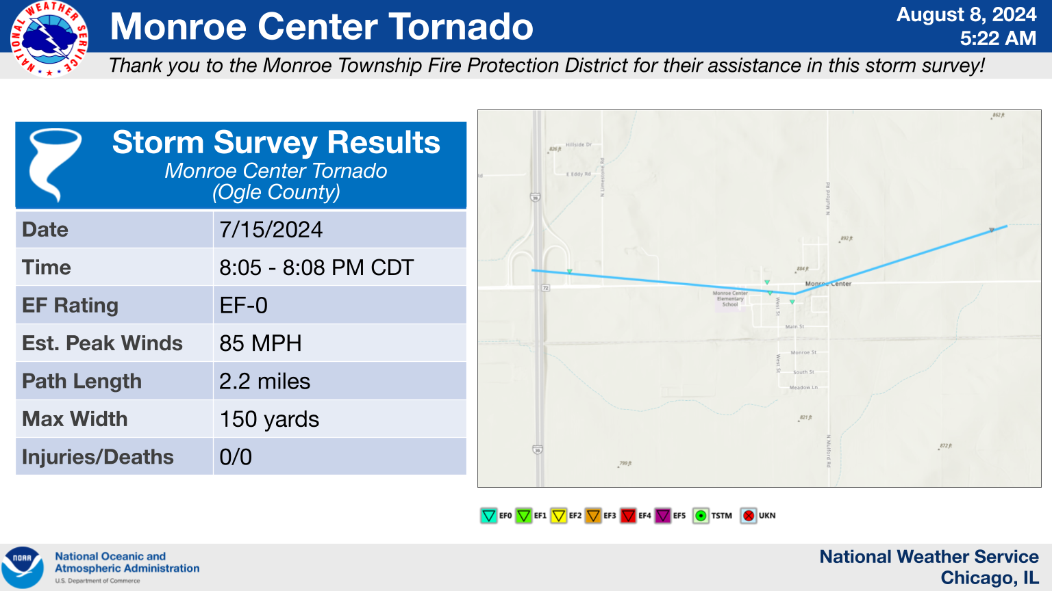
5.) Monroe Center, IL Tornado
|
(click on image to enlarge) |
|
Summary: A tornado began west of Monroe Center and flipped vehicles on the Route 72 northbound on-ramp to I-39 before tracking into Monroe Center, where it mainly caused tree damage. The tornado then appeared to turn to the northeast, with a narrow path of crop damage observed in high-resolution satellite imagery to the northeast of Monroe Center. The tornado is believed to have ended shortly after producing this crop damage. |
6.) Maple Park, IL Tornado
|
(click on image to enlarge) |
|
Summary: Radar data from KLOT depicted a circulation with a brief tornado debris signature. High-resolution satellite imagery depicted possible damage to crops in the path of rotation. The tornado will be rated EF-Unknown (EF-U) as it did not cause damage to any qualified damage indicators. |
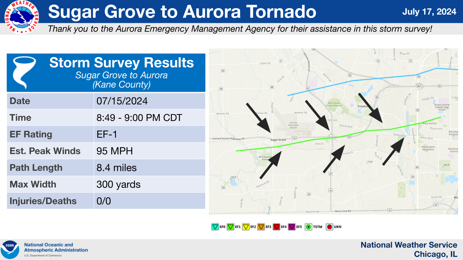
7.) Sugar Grove to Aurora, IL Tornado
|
(click on image to enlarge) |
|
Summary: This tornado developed just inside the entrance to Big Rock Campground, tracked across Sugar Grove, and then dissipated on the west side of Aurora. Extensive, primarily EF-0, tree damage was noted along the path. The tornado reached its strongest (EF-1) intensity in Sugar Grove, where several healthy trees were uprooted and/or snapped, and tossed some distance. Minor structural damage occurred to the Sugar Grove Fire Department building, some of which appeared to be caused by flying tree debris. An approximately 2,000 lb partial roof for firefighter training was lifted and moved a couple feet. Additional minor structural damage occurred at some residences in nearby subdivisions, with sporadic shingle and fascia damage noted into Aurora. The tornado then likely dissipated, with straight-line wind damage continuing downstream into portions of western and central DuPage County. |
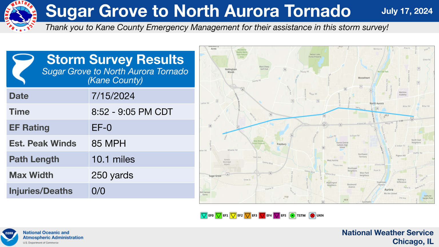
8.) Sugar Grove to North Aurora, IL Tornado
|
(click on image to enlarge) |
|
Summary: This tornado developed just west of Waubonsee Community College. It then tracked east-northeastward onto the college's campus, where it knocked several trees down, characteristic of higher-end EF-0 damage. A concentrated path of EF-0 tree damage and localized pole damage was found all the way into North Aurora. The tornado then likely dissipated near I-88 and Farnsworth Avenue, with straight-line wind damage continuing into portions of western and central DuPage County. |
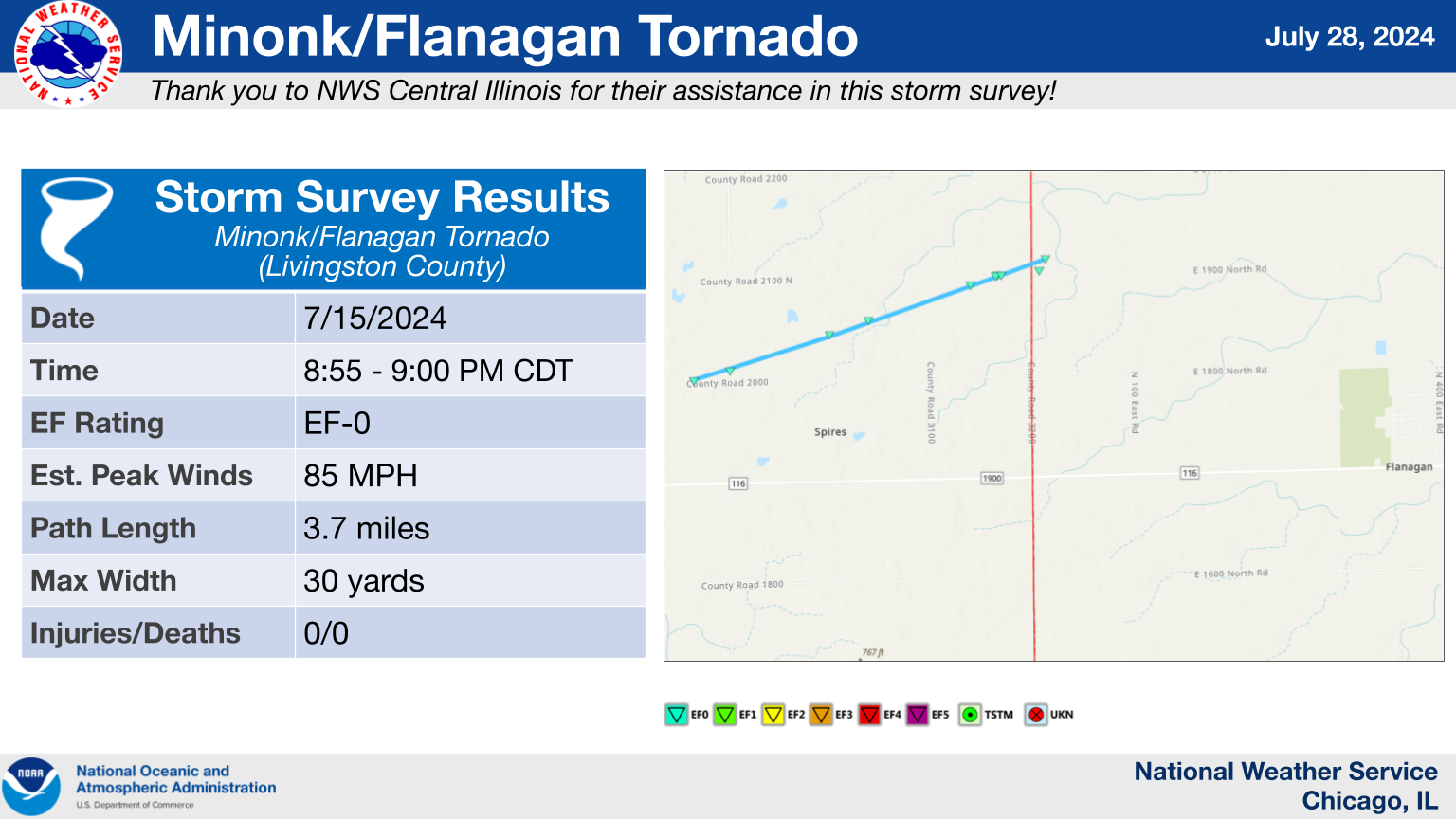
9.) Minonk/Flanagan, IL Tornado (Began in NWS Lincoln's Area of Responsibility)
|
(click on image to enlarge) |
|
Summary: This tornado began southeast of Minonk in Woodford County (NWS Lincoln's area of responsibility) and ended shortly after it crossed into Livingston County. It caused damage to corn crops, trees, and power poles along its 3.7 mile long path. |
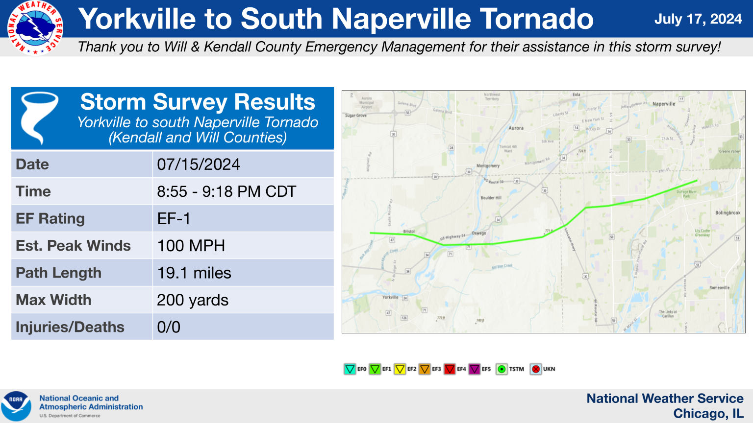
10.) Yorkville to Southern Naperville, IL Tornado
|
(click on image to enlarge) |
|
Summary: This tornado developed on the north side of Yorkville and tracked across Bristol, Oswego, far southeast Aurora, and then across portions of southwest and south Naperville. It produced extensive tree damage along its path, including a corridor in which numerous large trees were uprooted and snapped in a subdivision near IL-71 in Oswego, where the tornado reached its strongest (EF-1) intensity. The downed trees in this area also brought down power poles and wires. Aside from the EF-1 damage in portions of Oswego, the remainder of the tree damage was EF-0 caliber. Some minor structural damage was noted along the tornado's path as well, primarily fascia or shingle damage, along with damage caused by flying tree debris. |
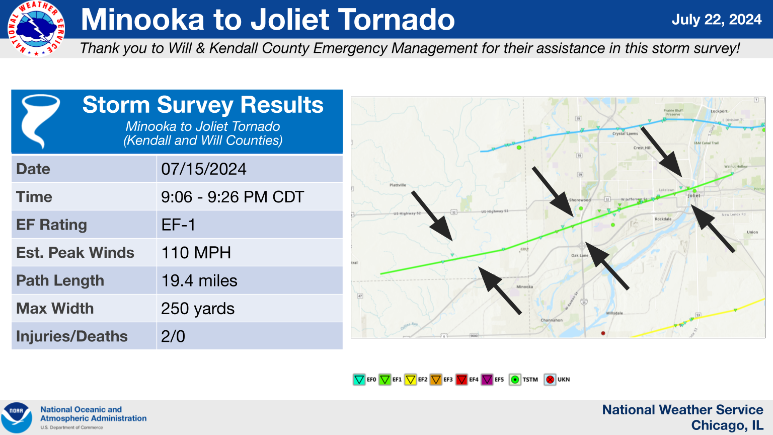
11.) Minooka to Joliet, IL Tornado
|
(click on image to enlarge) |
|
Summary: This tornado began west of Minooka, initially causing tree damage and loss of material on several outbuildings before causing additional tree damage as it tracked into the Summerfield subdivision of Minooka. The tornado continued east-northeastward into Shorewood, where it caused more tree damage, crop damage, and removed a portion of a roof off of a house, resulting in two injuries. Several trees were then uprooted in a neighborhood near the Joliet Regional Airport as the tornado entered Joliet. In the vicinity of US Highway 52 just east of Larkin Avenue, several wooden power poles were snapped. Roof damage to multiple buildings was also noted both to the west and east of Larkin Avenue. Additional tree and roof damage occurred into downtown Joliet before the tornado started to weaken as it crossed the Des Plaines River. East of the river, a path of tree damage continued until the intersection of US Route 6 and Briggs Street, which is where the tornado is believed to have dissipated. |
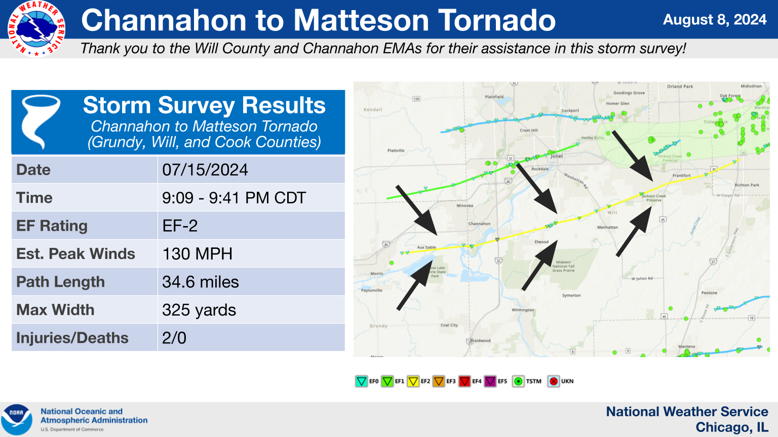
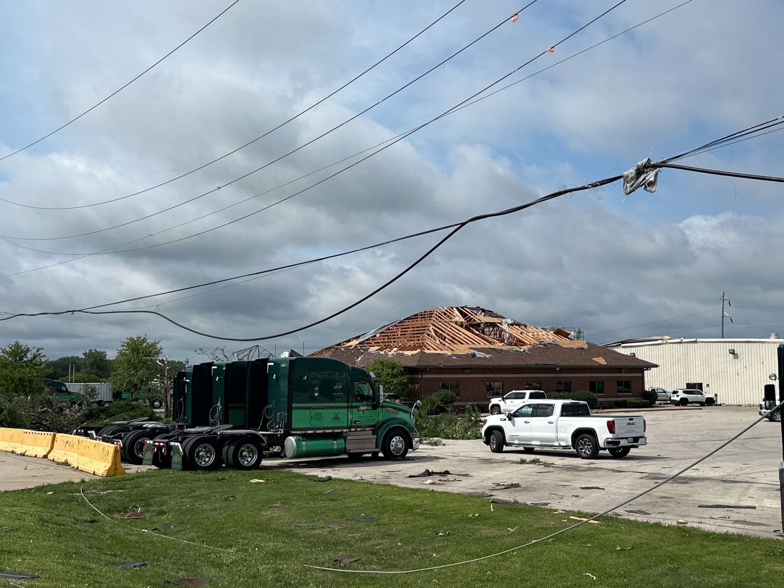
12.) Channahon to Matteson, IL Tornado
|
(click on image to enlarge) |
|
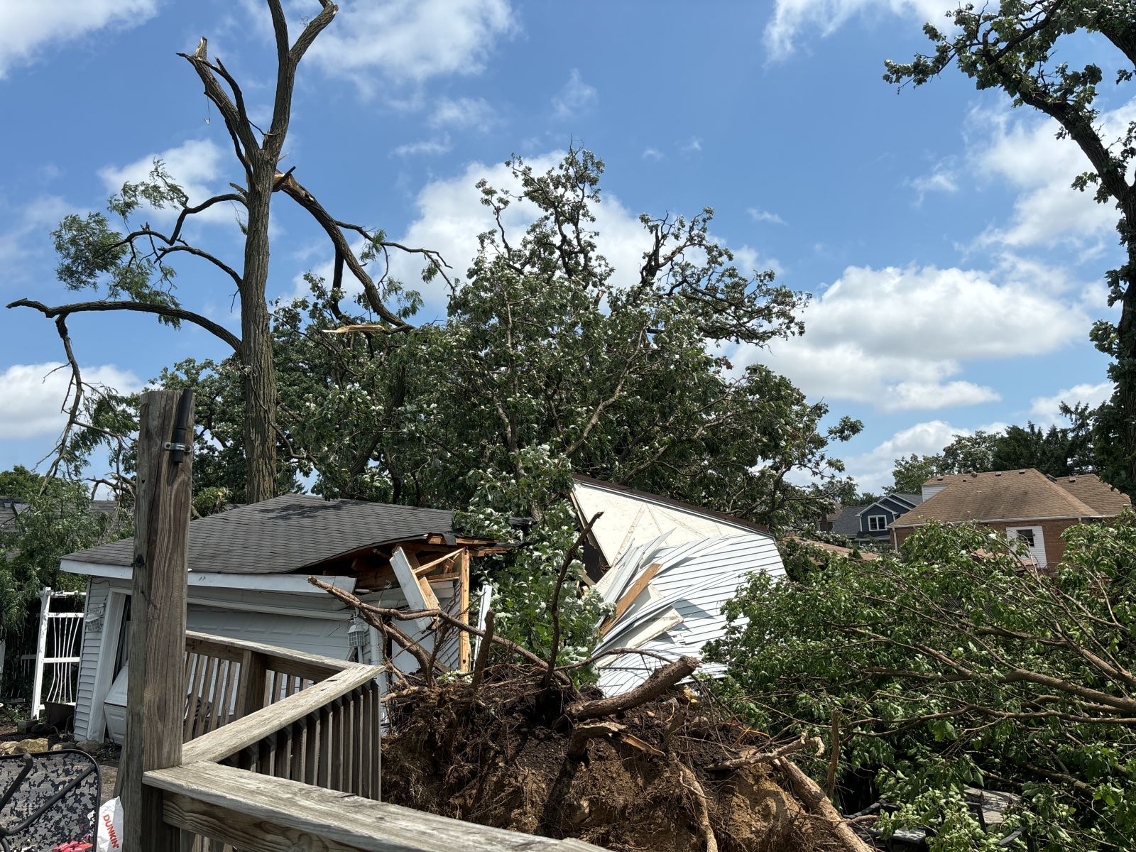
Summary: This tornado touched down northeast of Morris along Bungalow Road, where EF-0 damage to trees was observed. The tornado then intensified as it tracked eastward along the Illinois River into southern Channahon, where it downed several trees and power poles and caused roof damage to a few homes in Channahon's McKinley Oaks subdivision, consistent with an EF-1 rating. From here, the tornado continued east-northeastward, downing several high tension power lines and collapsing two metal support trusses near I-55, resulting in the EF-2 rating. At the adjacent Hoffman Transportation/G&D Trucking property, several semi-trucks and trailers were overturned, and an office building sustained significant roof damage. The tornado then continued east-northeastward into the north side of Elwood at a weaker intensity, but it was still strong enough here to snap and uproot numerous trees and cause roof damage to homes. The EF-0 to EF-1 caliber damage continued as the tornado crossed Illinois Route 53 and then US Route 52 near Manhattan, with mainly tree damage observed along this portion of the tornado's path, though some damage to homes and garages was noted here as well. Farther to the northeast in unincorporated New Lenox, additional tree and roof damage was observed, and a garage collapsed as a result of its door getting blown inward. Damage became more sporadic as the tornado continued northeastward into Frankfort, but became more concentrated in and near the Prestwick Country Club, where several trees were snapped or uprooted. More tree damage was observed into Matteson before the tornado eventually dissipated near I-57. This tornado tracked for about 34.6 miles during its 32 minute lifespan and did result in two injuries to motorists on I-55. |
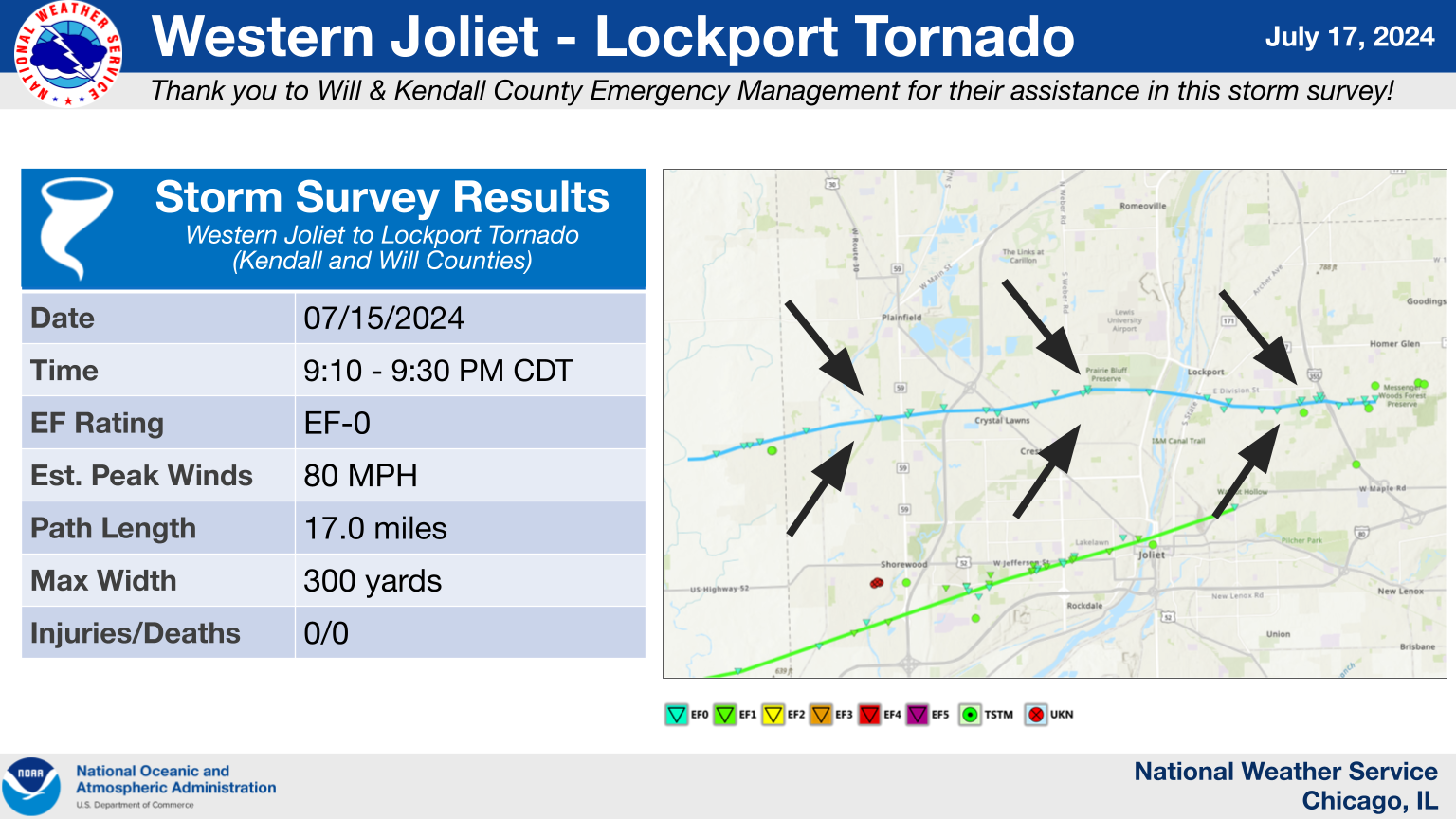
13.) Western Joliet to Lockport, IL Tornado
|
(click on image to enlarge) |
|
Summary: This tornado began in a field south of Caton Farm Road and west of Arbeiter Road before tracking into the Greywall Club subdivision of Joliet, where it caused damage to trees and fences. The tornado then tracked over Plainfield South High School, damaging its roof, before producing more tree damage across portions of western Joliet and southern Plainfield. Roof and fascia damage was also observed at St. John Lutheran Church near the Louis Joliet Mall, with more tree and minor structural damage occurring as the tornado continued eastward along Division Street towards the Des Plaines River. A path of damage to trees and fences then continued through Lockport before the tornado appeared to end near Cedar Road just east of I-355. |
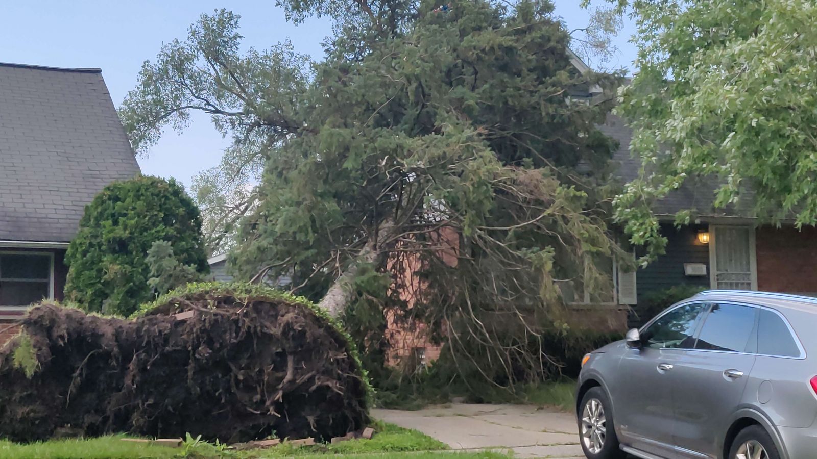
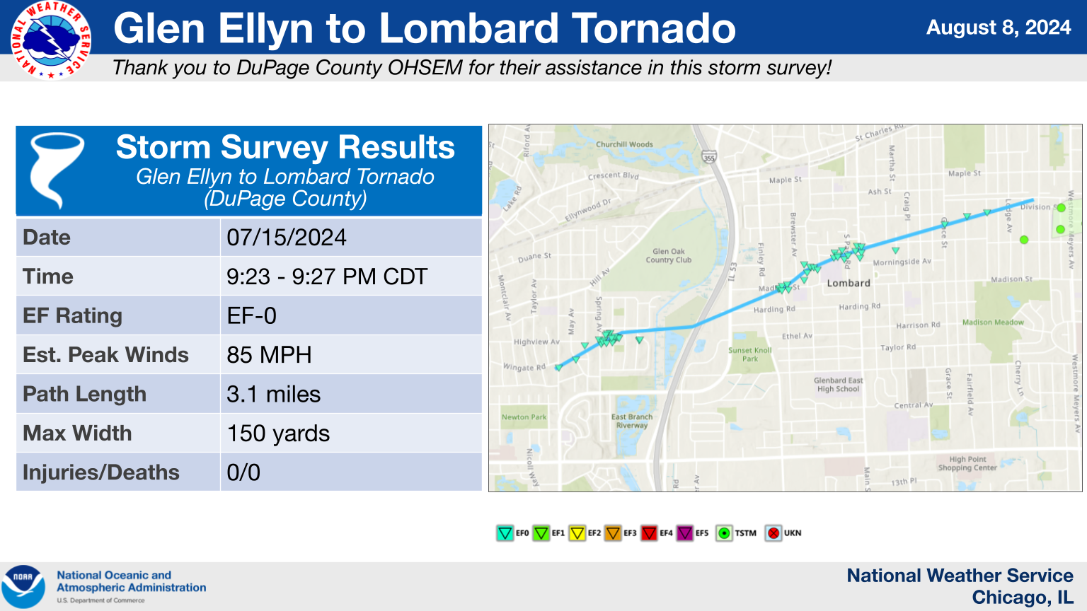
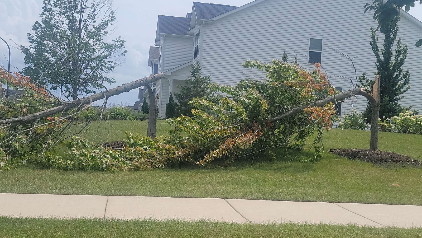
14.) Glen Ellyn to Lombard, IL Tornado
|
(click on image to enlarge) |
|
Summary: This tornado touched down in the vicinity of Bryant Avenue and Revere Road just south of Benjamin Franklin Elementary School. It tracked northeast and produced a concentrated corridor of tree damage between Spring and Woodstock Avenues and immediately south of Roslyn Road, where several large, healthy trees were either snapped or had limbs removed. Structural damage was generally limited, although gouges in stucco on the northwest corner of a residence on Cumnor Avenue were noted. The tornado tracked across the Veterans Memorial Tollway (I-355) and continued to produce tree damage in the vicinity of Madison Elementary School. A portion of a roof was damaged to one residence on Elizabeth Street. Damage became increasingly sparse towards Fairfield and Edgewood Avenues, where the tornado ended. |
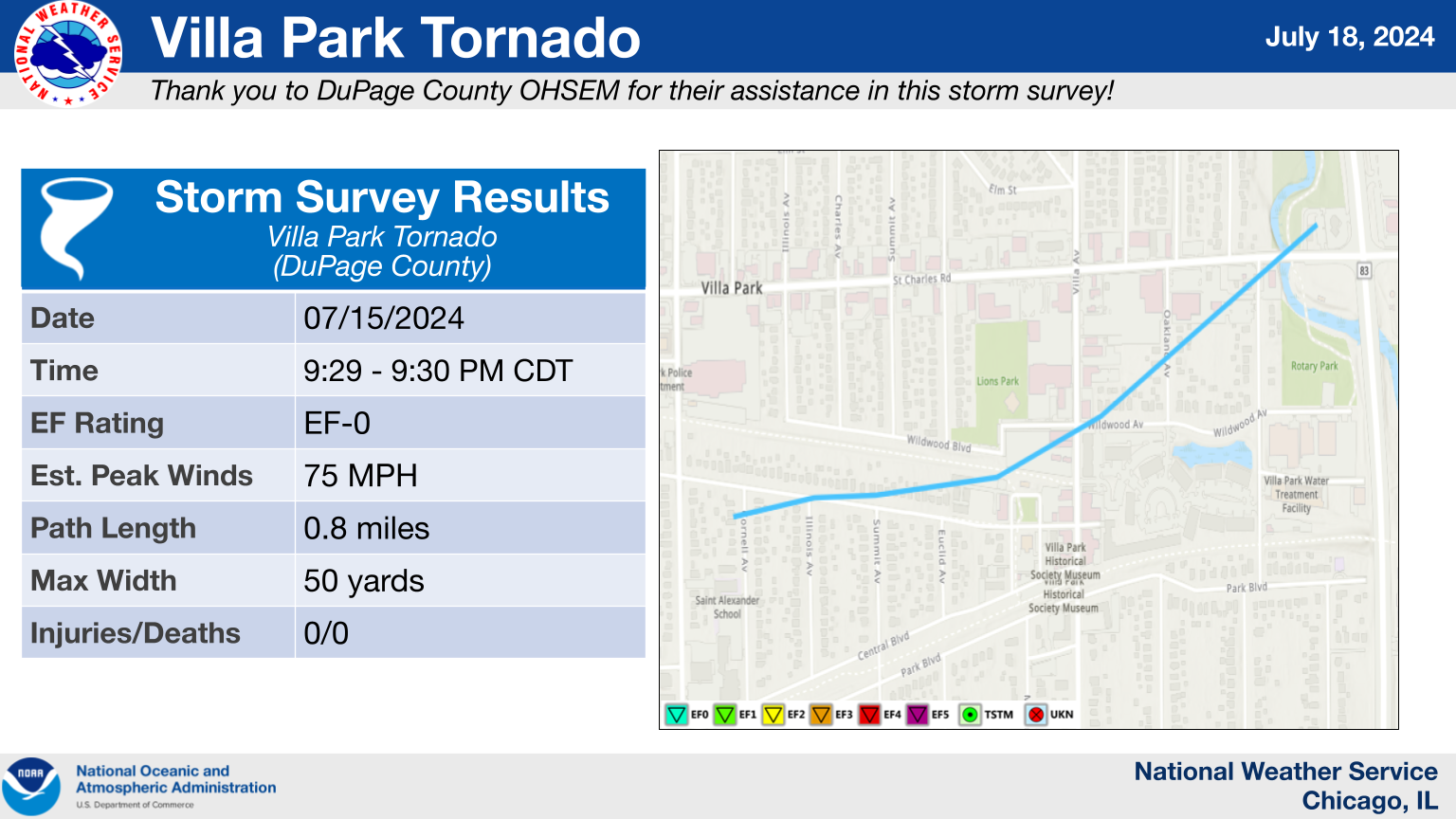
15.) Villa Park, IL Tornado
|
(click on image to enlarge) |
|
Summary: This brief tornado started near Kenilworth and Cornell Avenues northeast of Saint Alexander Catholic Church, where a highly localized corridor of tree damage was noted. To the southwest, broader straight-line wind damage was noted. This tornado crossed St. Charles Road and lifted west of Kingery Highway. This tornado was on the ground for about one minute. |
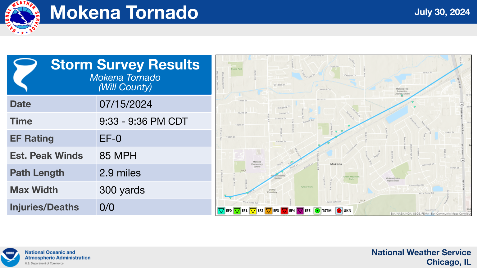
16.) Mokena, IL Tornado
|
(click on image to enlarge) |
|
Summary: Within a broader corridor of straight-line wind damage, an EF-0 tornado occurred in Mokena. The tornado began near Francis Road just west of Front Street, then roughly paralleled Front Street and the railroad tracks through downtown Mokena before ending near US Route 45. Damage along the tornado's path was characterized by numerous downed trees and branches, downed fences, and a few instances of structural damage, mainly to the roofs of a few buildings. |
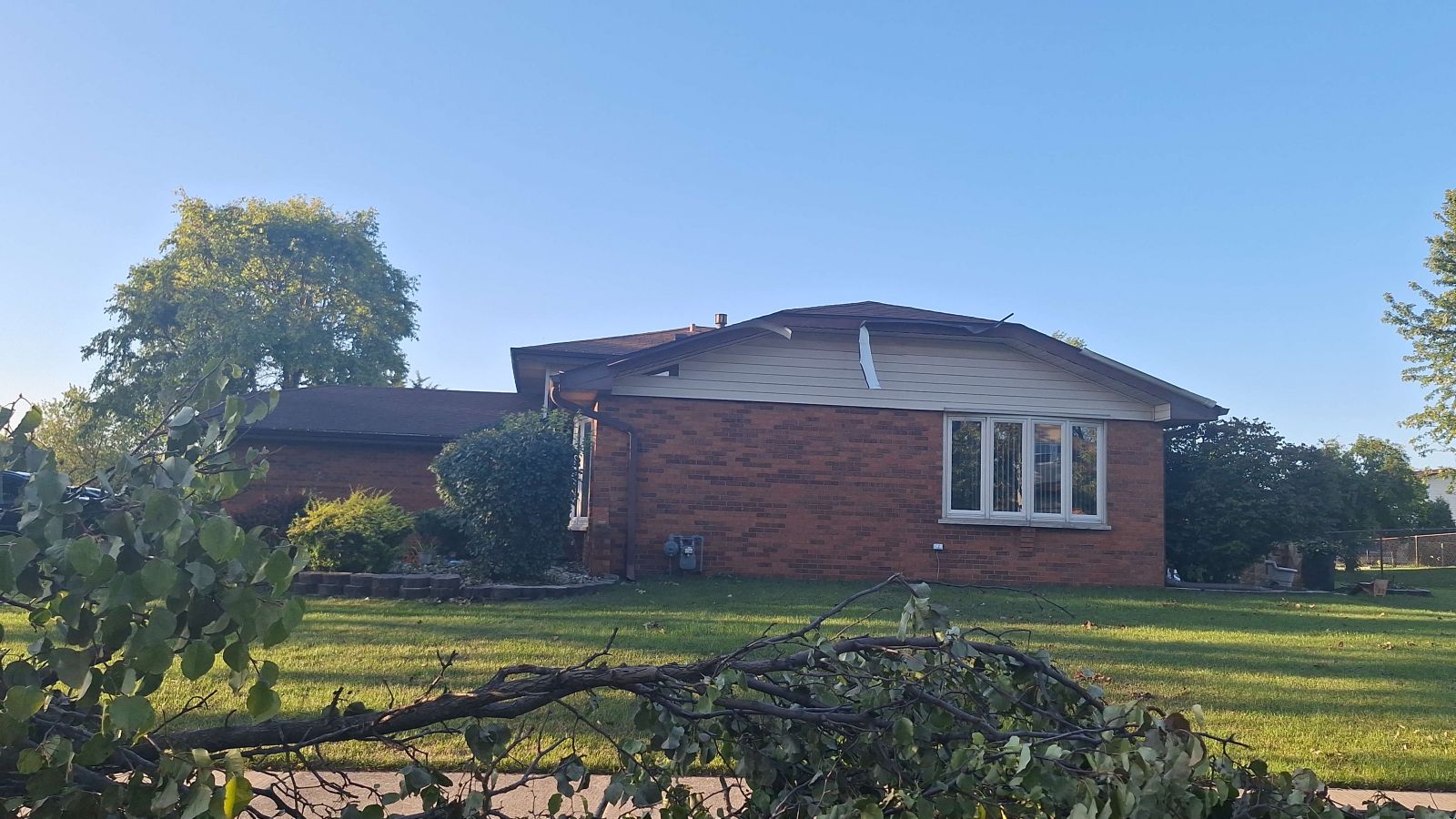
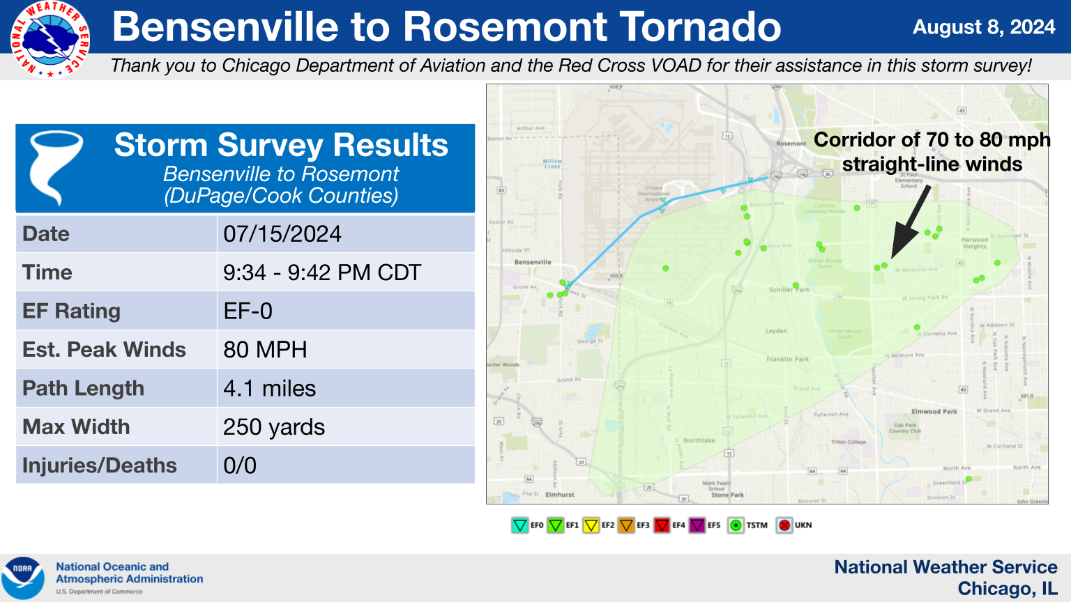
17.) Bensenville to Rosemont, IL Tornado
|
(click on image to enlarge) |
|
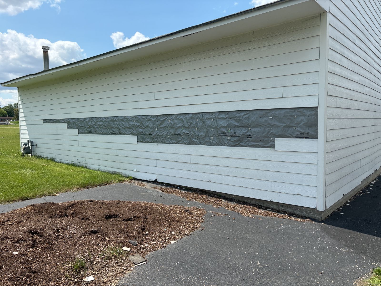
Summary: Based on radar data, observational data from an automated platform, videos taken nearby, and damage reports provided by local officials, it was determined that an EF-0 tornado impacted Chicago O'Hare International Airport. The tornado started just southwest of the airport in Bensenville, where it damaged trees. As the tornado moved over the airport, windows, doors, and exterior paneling and roofing of multiple terminals were damaged. Carts and loose objects were pushed around or thrown, as well. The tornado appeared to dissipate just east of Mannheim Road, where an area of damage to exterior fences was noted. |
18.) Manteno, IL Tornado
|
(click on image to enlarge) |
|
Summary: This tornado began near N 2250W Road and W 7000N Road, where it initially caused tree damage. The tornado tracked east-northeast across US Route 45 and I-57 into the south side of Manteno, where numerous trees were damaged and fascia, shingle, and fencing damage was observed at several residences. Several modular homes in a mobile home park in southeastern Manteno sustained skirt and siding damage from this tornado as it continued east-northeastward. Roofing material was also torn off of the Urban Farmer and Lowe's distribution centers by the tornado. After exiting Manteno, the tornado tracked along E 9000N Road for a few miles, damaging trees, power lines, and farm outbuildings before dissipating in a field just east of N 9000E Road. All damage sustained was consistent with an EF-0 rating. |
19.) Broadview, IL Tornado
|
(click on image to enlarge) |
|
Summary: A tornado began on the far east side of Westchester and tracked into Broadview, where surveillance footage captured it causing roof, siding, and window damage to the B.L. Downey Company facility. The tornado continued eastward from there, peeling off portions of the roofs of three apartment buildings along S 25th Avenue north of Roosevelt Road and depositing the roofing material into the alleyway adjacent to the east. The remainder of the damage caused by the tornado in Broadview was mainly confined to trees. While the tornado is believed to have ended near S 12th Avenue, it may have continued intermittently farther to the northeast into Forest Park and Oak Park, but the in-person damage survey did not find conclusive evidence of a continuous tornado path. |
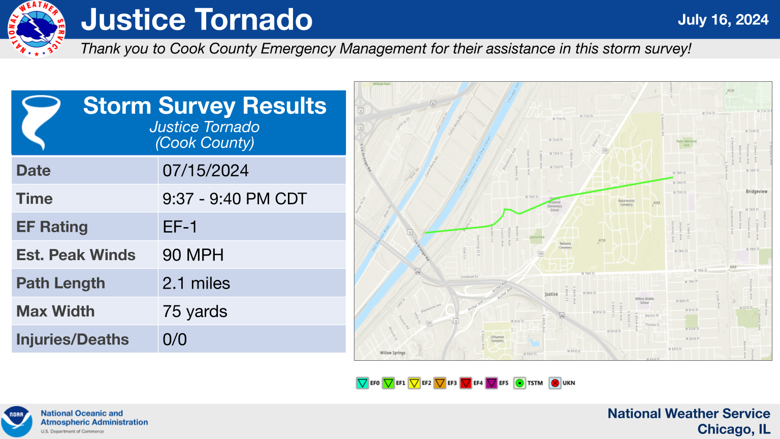
20.) Justice, IL Tornado
|
(click on image to enlarge) |
|
Summary: This tornado appears to have began near the Chicago Sanitary and Ship Canal immediately north of the Tri-State Tollway (I-294). It tracked across a mobile home park, where it caused damage to trees and homes north of Park Avenue, consistent with an EF-0 rating with winds near 80 mph. Farther to the south, additional damage to trees was aligned in a generally easterly and northeasterly direction, consistent with straight-line wind damage. The tornado crossed Garden Lane, where several large, healthy trees were either uprooted or snapped. Minor shingle, siding, and fascia damage was also observed, and a greenhouse was also blown about 75 feet to the north. Damage in this area was consistent with an EF-1 tornado with winds near 90 mph. This tornado then continued into Resurrection Cemetery. Damage then broadened considerably east of South Roberts Road, indicating that the tornado likely dissipated and transitioned to a concentrated corridor of straight-line winds. |
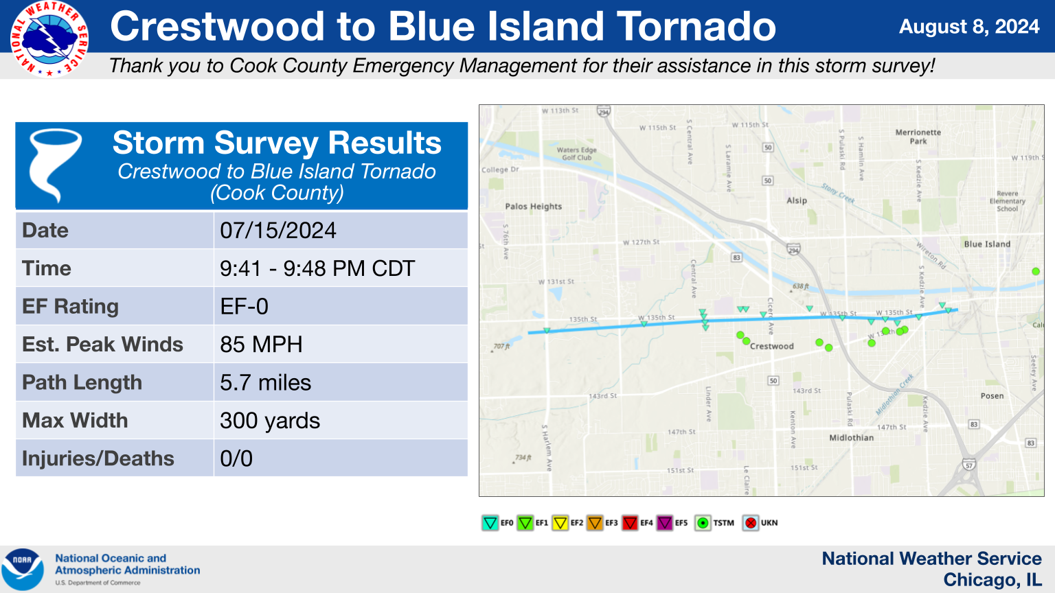
21.) Crestwood to Blue Island, IL Tornado
|
(click on image to enlarge) |
|
Summary: This tornado started near S Harlem Avenue and W 135th Street and tracked nearly due east, paralleling W 135th. Minor roof damage to a residence and a large uprooted tree was found near Nathan Hale Primary School, consistent with high-end EF-0 wind speeds. The tornado continued eastward across the Tri-State Tollway (I-294) before dissipating immediately east of S Kedzie Avenue and south of the Cal-Sag Channel. |
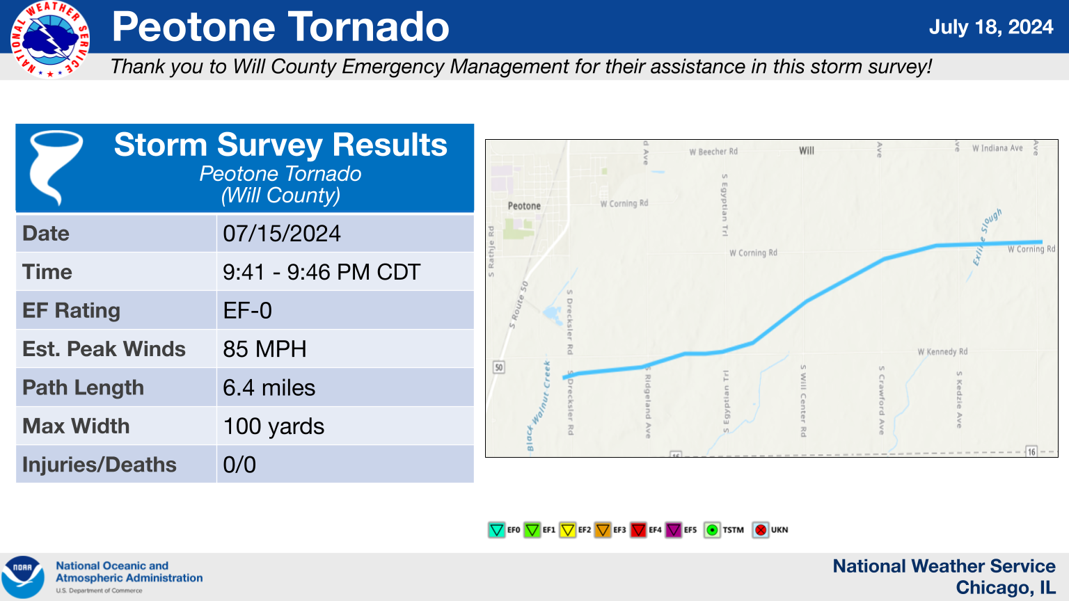
22.) Peotone, IL Tornado
|
(click on image to enlarge) |
|
Summary: This tornado began near the intersection of Drecksler Road and Kennedy Road south of Peotone, where tree damage was observed. The tornado tracked nearly due east along Kennedy Road for the first part of its life cycle, causing mostly tree damage along the way. Though, a collapsed outbuilding and broken windows were also observed to two homes near Egyptian Trail, in addition to the collapse of an outbuilding. From here, the tornado turned northeast until it reached the intersection of Crawford Avenue and Corning Road, where it turned eastward again. Most of the damage within this section of the track remained primarily to trees, but some roof damage to an outbuilding and a home was observed as well -- all of which was consistent with an EF-0 rating. The tornado dissipated just east of Western Avenue after blowing shingles off of a house and destroying a chicken coop at the same residence, with the damage path going into Beecher becoming broader and more consistent with straight-line wind damage. |
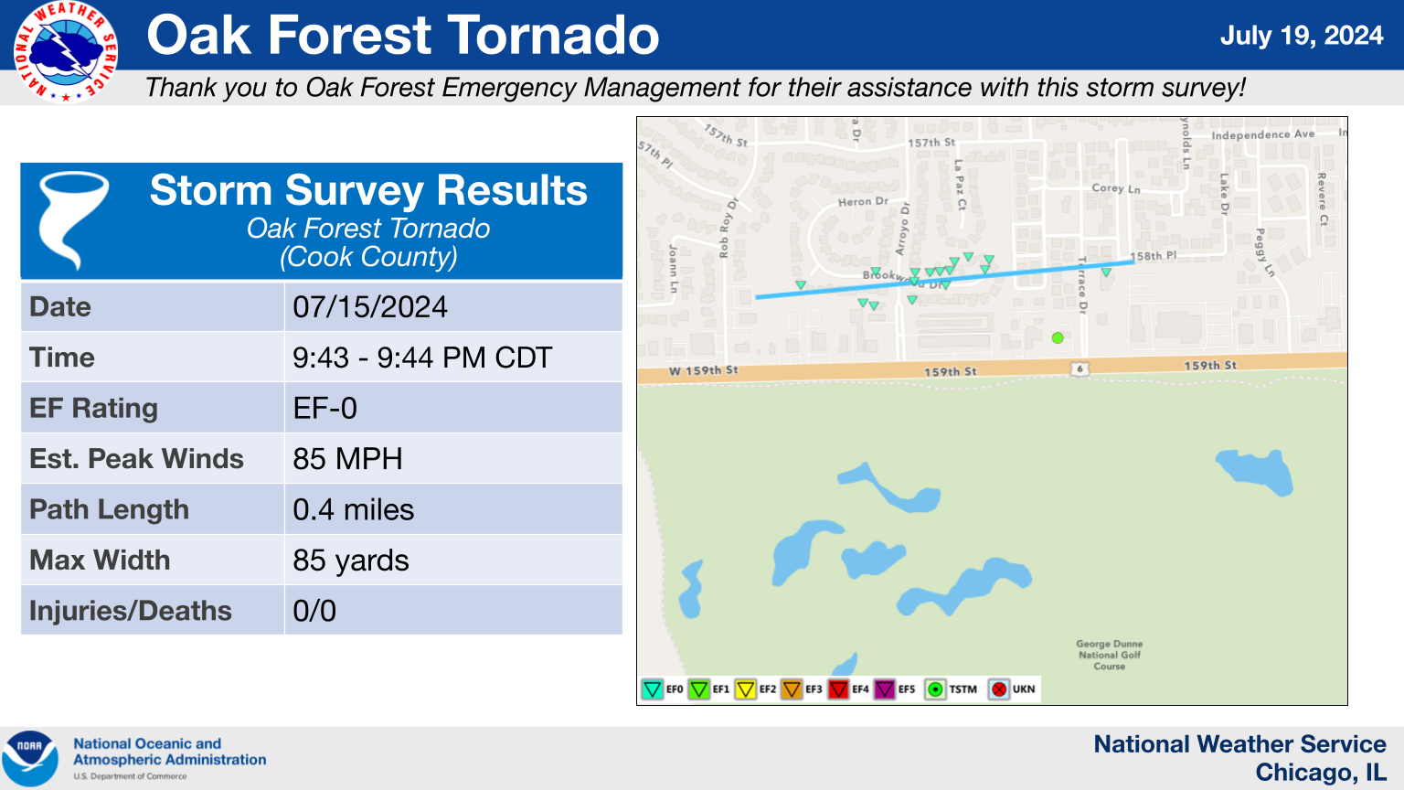
23.) Oak Forest, IL Tornado
|
(click on image to enlarge) |
|
Summary: This brief tornado began just north of 159th Street near Rob Roy Drive and produced a narrow region of damage to trees and some residences, primarily confined to areas along Brookwood and Arroyo Drives. Some instances of shingle and fascia damage were noted. At one house just west of Arroyo Drive, damage was noted to vinyl fencing, siding, gutters, along with a broken window in the back, consistent with high-end EF-0 winds. The tornadic circulation appears to have ended prior to Central Avenue, with sporadic wind damage in the Jewel-Osco parking lot associated with straight-line winds. |
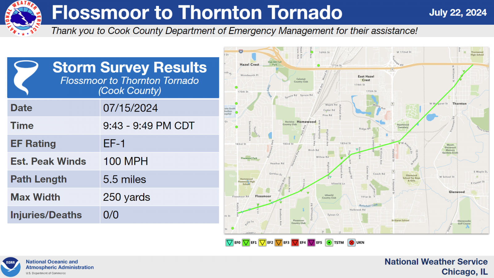
24.) Flossmoor to Thornton, IL Tornado
|
(click on image to enlarge) |
|
Summary: This tornado began near Kedzie Avenue south of Homewood-Flossmoor High School and tracked northeastward for about 5.5 miles through Flossmoor, Homewood, Glenwood, and Thornton before dissipating as it reached I-80. It produced extensive tree damage and some structural damage along its track, which included the roof of the Thornton Recreation Center getting partially ripped off. |
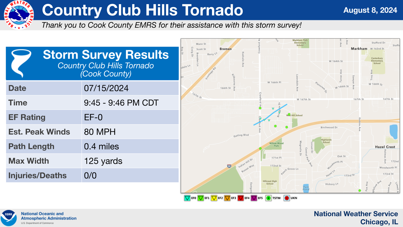
25.) Country Club Hills, IL Tornado
|
(click on image to enlarge) |
|
Summary: This brief tornado began near the Wal-Mart south of the intersection of 167th Street and Crawford Avenue in Country Club Hills. It tracked northeastward into the subdivision east of the Wal-Mart, producing a concentrated corridor of tree damage before dissipating as it approached 167th Street. |
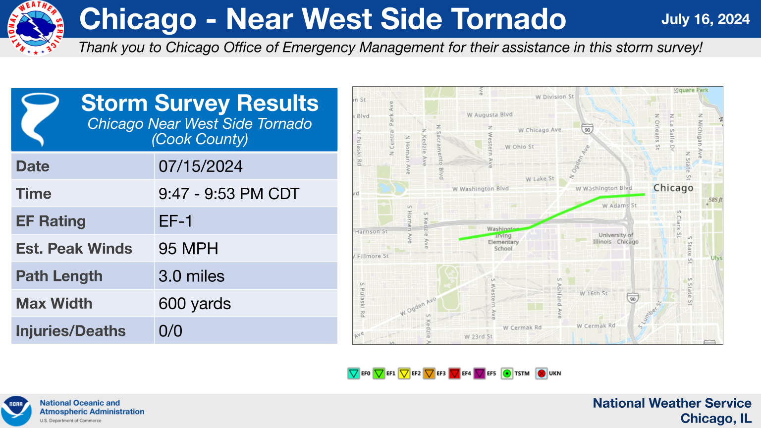
26.) Chicago, IL: Near West Side Tornado
|
(click on image to enlarge) |
|
Summary: This tornado's path began along I-290 near Francisco Avenue in the Near West Side community area of Chicago, where tree damage was noted. Several areas of more extensive tree damage, including uprooted mostly healthy trees, were found near Rush and Stroger Hospitals as the tornado tracked eastward. The most significant damage was noted near Skinner Park and the Chicago Police Academy, where several healthy trees were uprooted, there was roof damage to a building in Skinner Park, and the Chicago Police Academy building sustained some minor fascia damage. The tornado then continued eastward to near the Chicago River, where it dissipated. |
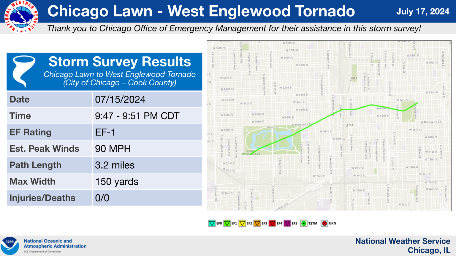
27.) Chicago, IL: Chicago Lawn to West Englewood Tornado
|
(click on image to enlarge) |
|
Summary: This tornado began on the southwest side of Marquette Park, where several large willow trees were snapped near their bases. A concentrated corridor of tree damage continued northeast across the park and golf course. All of the EF-1 damage with this tornado took place within Marquette Park. Damage, primarily to trees, continued in a generally northeastward path through the West Englewood community area. The tornado lifted just east of William Ogden Park. Sporadic damage, consistent with straight-line winds, continued eastward all the way to the lakefront. |
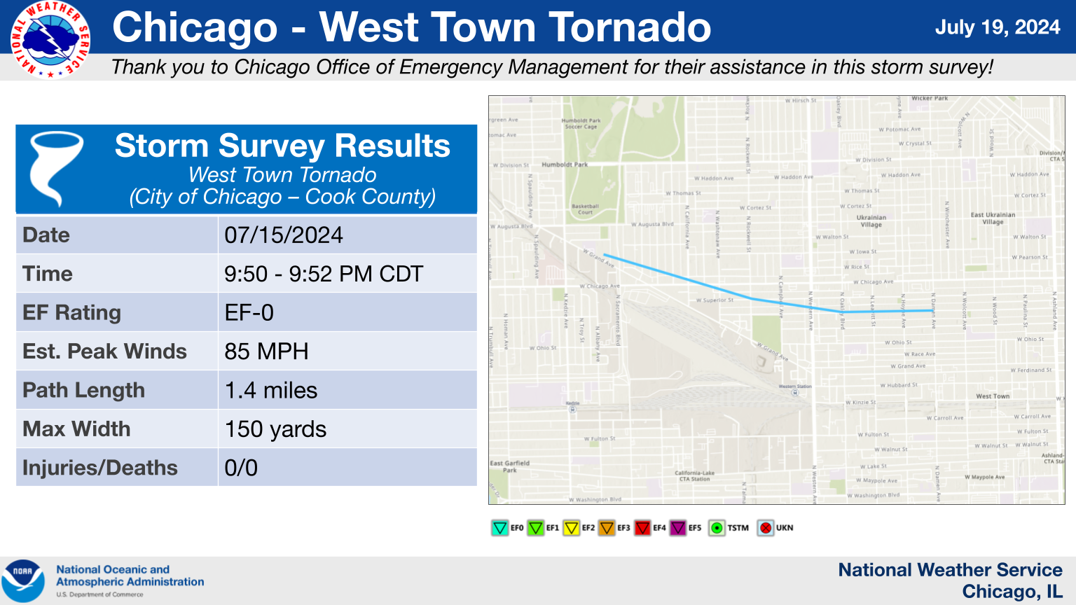
28.) Chicago, IL: West Town Tornado
|
(click on image to enlarge) |
|
Summary: An EF-0 tornado with peak winds around 85 mph started near N Sacramento Boulevard and W Grand Avenue and continued east-southeastward for about 1.4 miles before ending near W Huron Street and N Damen Avenue. Damage along the path of the tornado consisted of uprooted trees, downed large tree branches, blown out windows, and damage to the roofing and siding of buildings. |
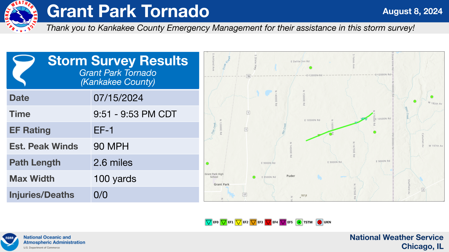
29.) Grant Park, IL Tornado
|
(click on image to enlarge) |
|
Summary: This tornado began in a field just east of N 14500 E Road and north of E 9000N Road in northeast Kankakee County at 9:51 PM CDT. Shortly afterwards, the tornado peeled a significant portion of roofing material off of a building at a Daybreak Foods facility and rolled a semi-trailer in the adjacent parking lot, which is consistent with an EF-1 rating. From here, the tornado tracked northeast across mainly open fields, resulting in little damage until after it crossed N 16750E Road. At this point, it caused damage to trees and a few residences along E 10500N Road, which sustained shingle and fascia damage. The tornado dissipated in the field northeast of the homes just west of N 17500E Road at 9:53 PM CDT. |
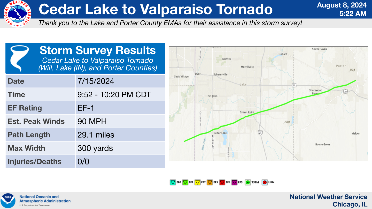
30.) Cedar Lake to Valparaiso, IN Tornado
|
(click on image to enlarge) |
|
Summary: This tornado began near Eagle Lake in eastern Will County, IL, initially producing damage to an outbuilding and several trees. The tornado continued east-northeastward towards Cedar Lake, IN, where it damaged the chimney and garage of a home just east of US-41, consistent with an EF-1 rating. From here, the tornado continued northeastward across the northern edge of Cedar Lake towards the south side of Crown Point, causing EF-0 caliber damage to trees along the way. The damage in Crown Point was mainly confined to trees and fences, but an industrial building did sustain damage consistent with an EF-1 rating as the tornado exited Crown Point near Indiana State Route 53. The tornado then continued across I-65 through eastern Lake County and into Porter County. Damage along this part of the tornado's path was entirely to trees as the tornado had weakened a bit. However, the tornado did re-intensify as it tracked into Valparaiso, where it continued to down large tree limbs and even caused damage to a home and vehicle as a result of fallen trees. The tornado ended just north of Evans Avenue and west of Indiana State Route 49 on the east side of Valparaiso. This EF-1 tornado traveled 29.1 miles during its 28 minute lifespan, but caused no injuries or fatalities. One fatality in Cedar Lake was caused by straight-line winds south of the tornado's track downing a large tree limb onto a house. |
31.) Lowell, IN Tornado
|
(click on image to enlarge) |
|
Summary: A concentrated corridor of damage across Lowell was determined to have been caused by both straight-line winds and an EF-0 tornado. The tornado is believed to have tracked to the east-northeast south of State Route 2 from west of Austin Street to Evergreen Park. This is where tree damage was most significant in Lowell, and a couple of houses suffered roof and fascia damage as well. |
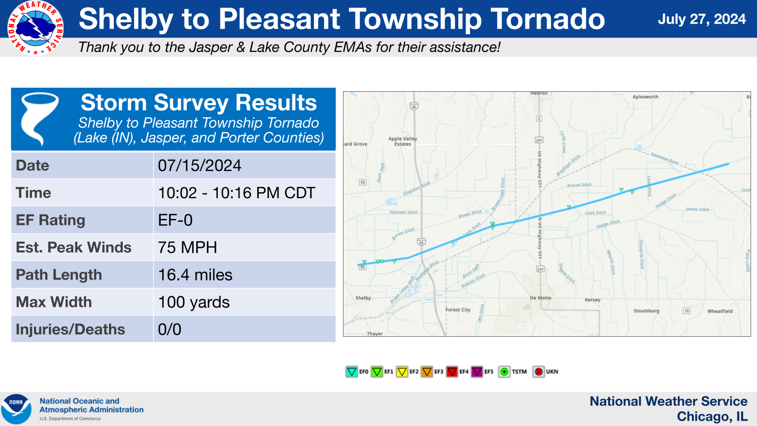
32.) Shelby to Pleasant Township, IN Tornado
|
(click on image to enlarge) |
|
Summary: This tornado started to form just west of state route 55 north of Shelby, IN in Lake County and tracked east-northeastward, crossing over I-65 and US Highway 231 into northern Jasper County before crossing into southern Porter County, where it finally weakened and dissipated. Damage consisted of damaged crops, downed trees, downed large tree branches (including some that fell onto and damaged roofs of houses), and roof paneling being peeled off of a storage facility. |
The Enhanced Fujita (EF) Scale classifies tornadoes into the following categories:
| EF0 Weak 65-85 mph |
EF1 Moderate 86-110 mph |
EF2 Significant 111-135 mph |
EF3 Severe 136-165 mph |
EF4 Extreme 166-200 mph |
EF5 Catastrophic 200+ mph |
 |
|||||
When a tornado is known to have occurred but does not cause damage to any qualified damage indicators, or if the only damage is located in an area that is inaccessible to NWS storm survey personnel, then a tornado may be assigned the EF-Unknown (EF-U) rating.
Damaging Winds
|
|
 |
 |
|
|
| Estimated peak winds across the NWS Chicago area. | Estimated peak winds across portions of Winnebago, Ogle, and DeKalb counties in Illinois. | Estimated peak winds across portions of Kane, DuPage, Cook, and Will counties. |
|
|
|
|
| Estimated peak winds across portions of Lake, Porter, Newton, and Jasper counties in Indiana. | Estimated peak winds across portions of Livingston, Ford, and Iroquois counties in Illinois. |
|
Downloadable KMZ File with All Damage Survey Findings Downloadable Shapefile with All Damage Survey Findings
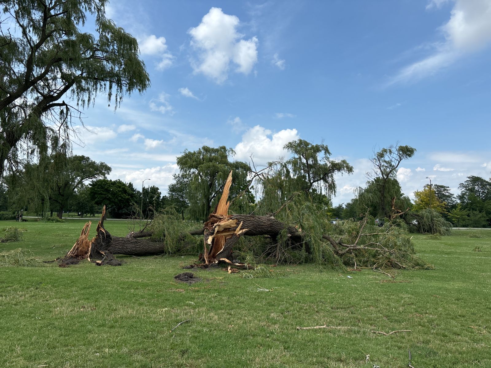
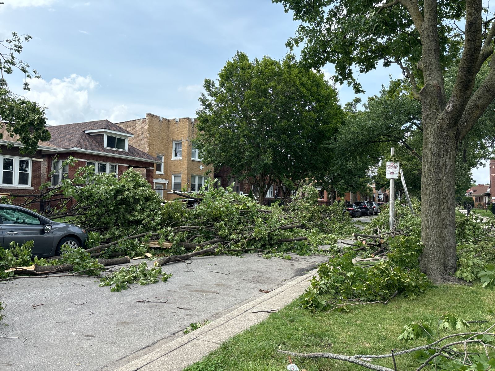
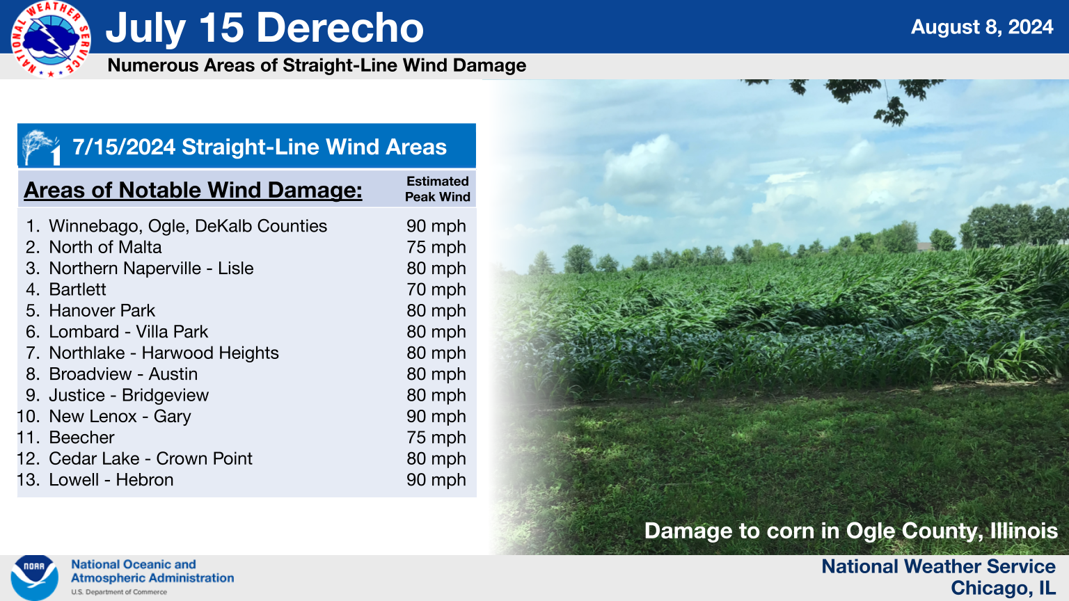
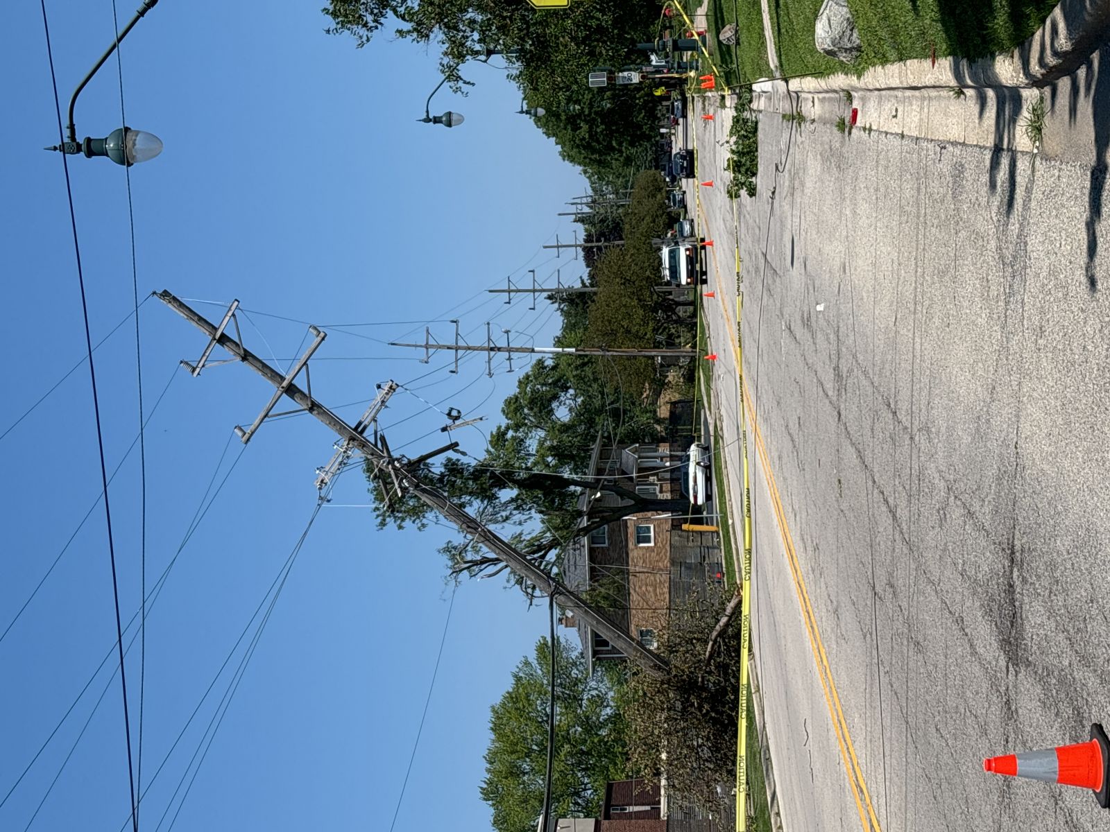
In addition to numerous tornadoes, the July 15 derecho caused widespread straight line wind damage including multiple swaths of significant wind damage. Below are a few selected swaths of damage that we surveyed. An interactive map with all of this information can be found on our Damage Assessment Toolkit Viewer website (to see the data from this event, make sure that the date range in the top right corner includes this event's date). Instructions for how to download survey data (KMZ files and shapefiles) are available here. |
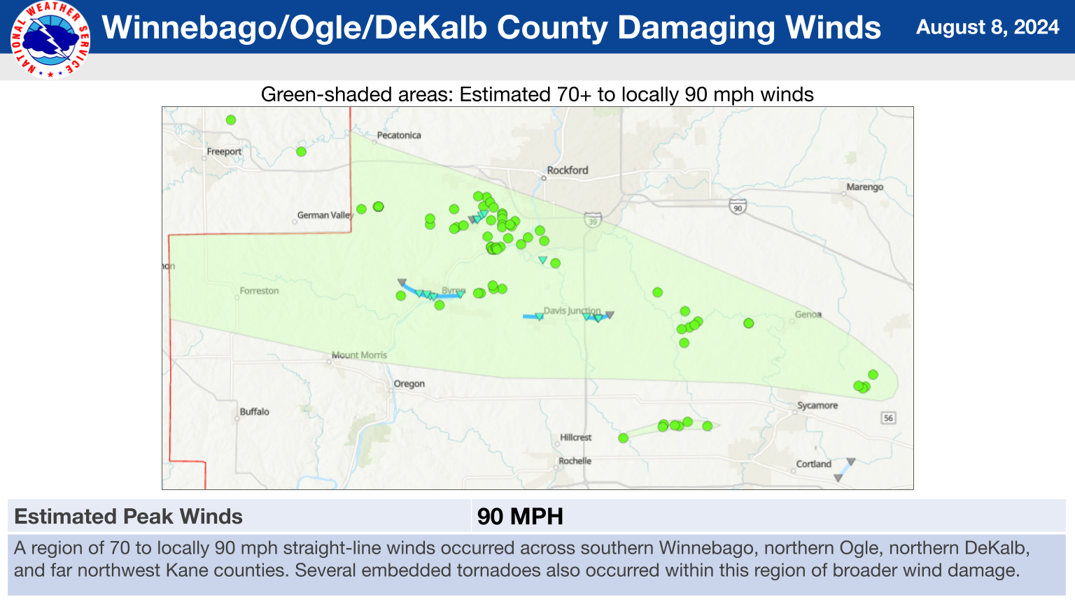
1.) Winnebago, Ogle, DeKalb, Kane County Straight-Line Winds
|
(click on image to enlarge) |
|
Summary: A region of 70 to locally 90 mph straight line winds occurred across southern Winnebago, northern Ogle, northern DeKalb, and far northwest Kane counties. Across this corridor, numerous trees were snapped or uprooted, several patches of crops were blown down, multiple outbuildings were damaged, and several empty shipping containers were blown around at Rockford Airport. Several embedded tornadoes also occurred within this region of broader wind damage. |
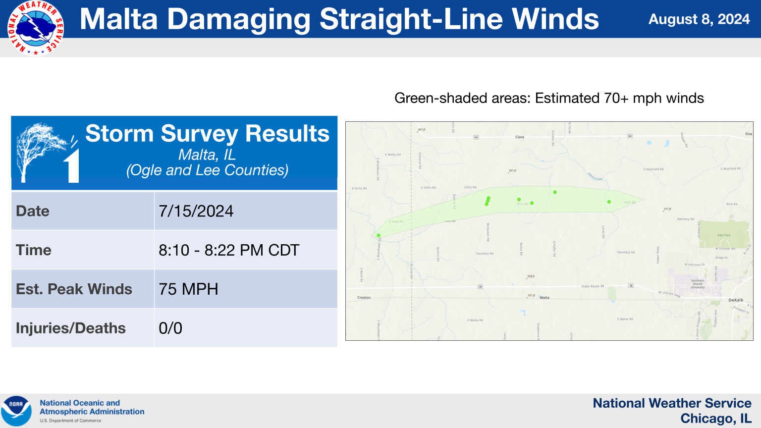
2.) Malta Straight-Line Winds
|
(click on image to enlarge) |
|
Summary: A corridor of damage to trees and crops was observed north of Malta, IL. |
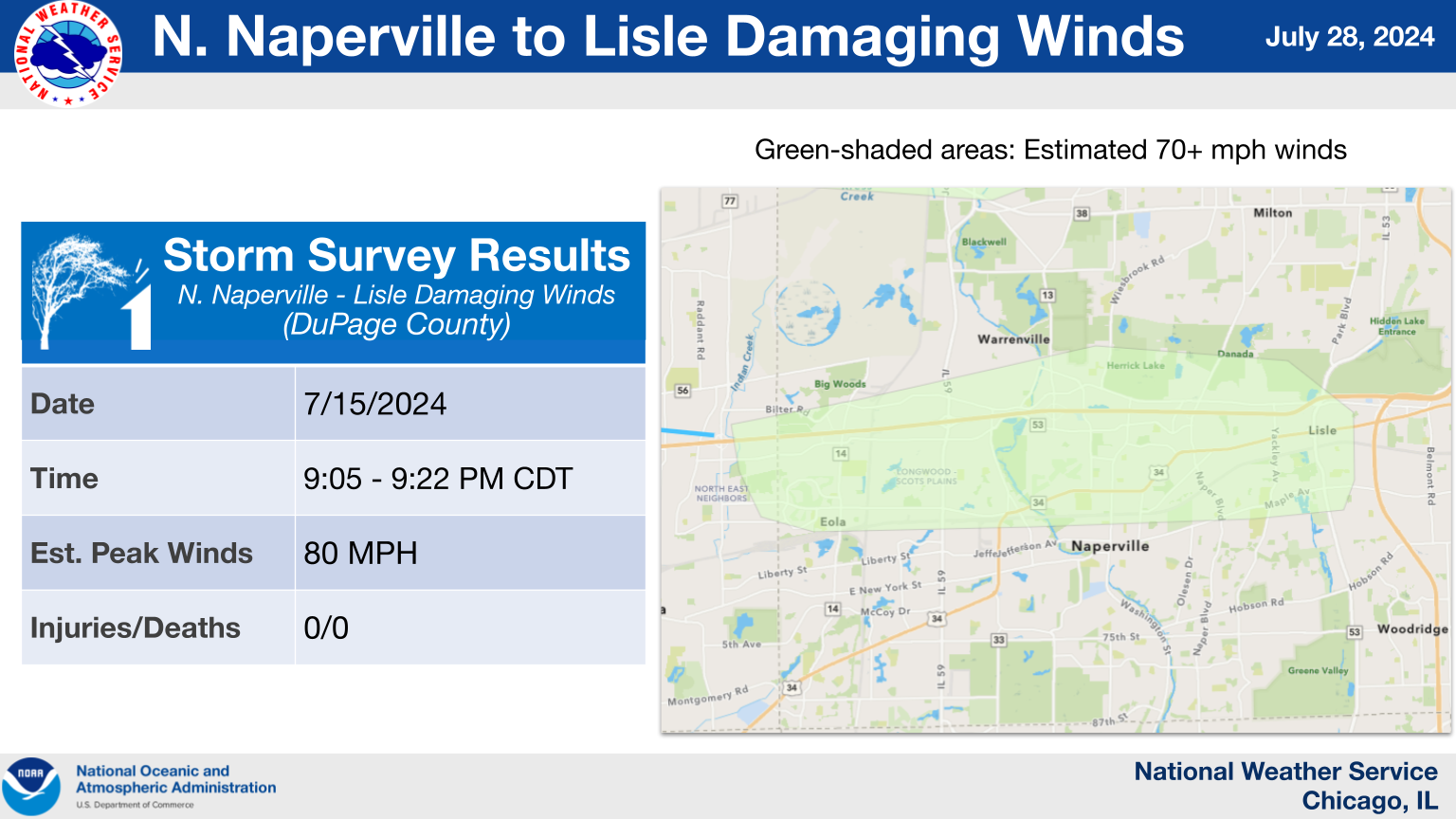
3.) Northern Naperville to Lisle Straight-Line Winds
|
(click on image to enlarge) |
|
Summary: After the Aurora area tornadoes ended, a consolidated corridor of strong straight-line winds passed through portions of Naperville, Warrenville, and Lisle, producing widespread tree damage. |
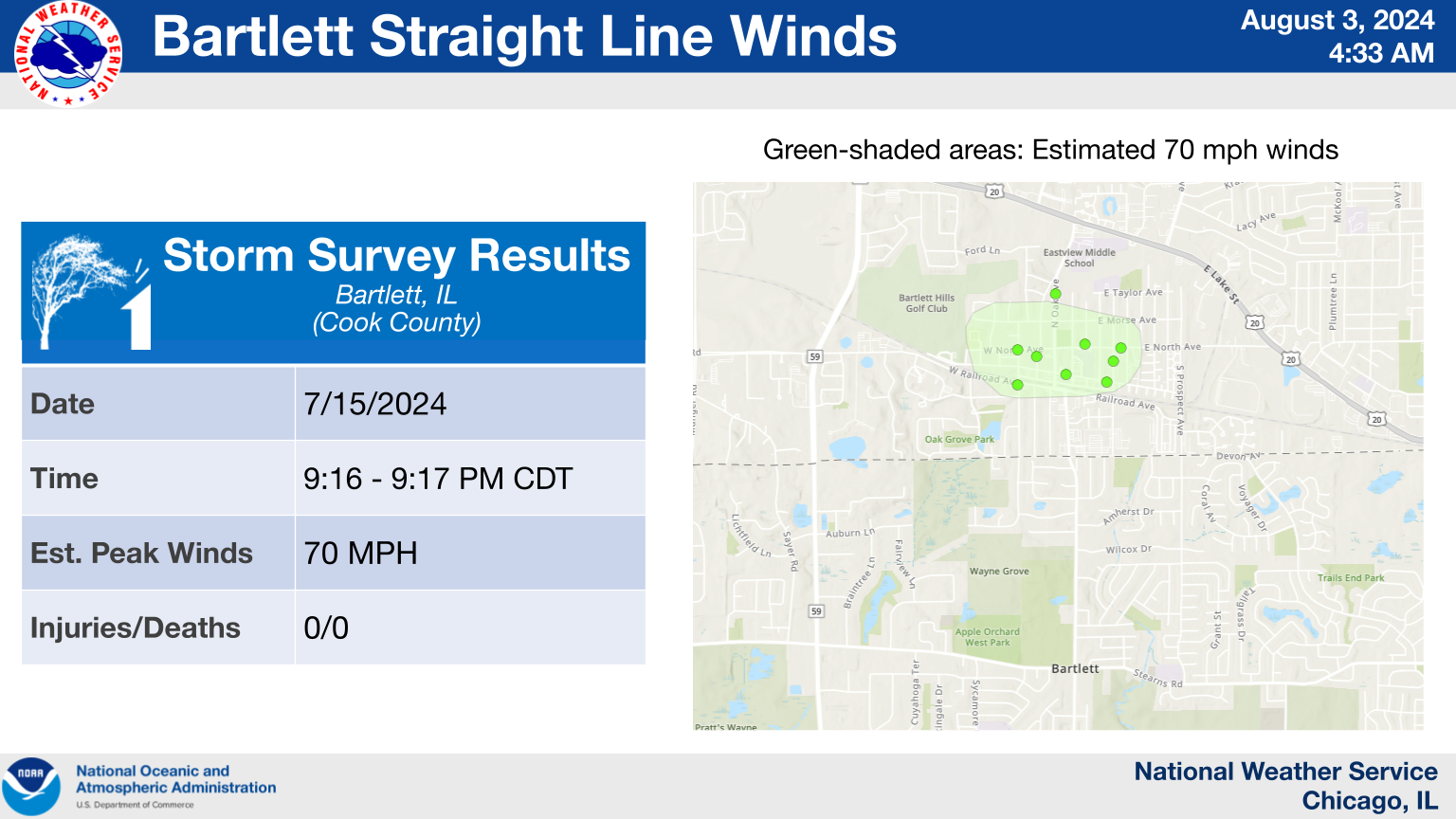
4.) Bartlett Straight-Line Winds
|
(click on image to enlarge) |
|
Summary: A localized corridor of tree damage occurred on the north side of Bartlett. The observed damage was consistent with straight-line winds of about 70 mph. |
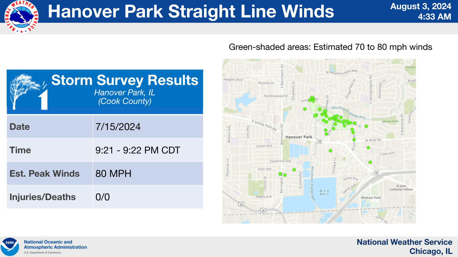
5.) Hanover Park Straight-Line Winds
|
(click on image to enlarge) |
|
Summary: A concentrated corridor of damage to trees, fences, and the siding and roofs of townhouses occurred on the north side of Hanover Park. Radar data and eyewitness accounts suggest that most or all of this damage was caused by straight-line winds, though it is possible that a brief tornado occurred in this area as well, particularly near the intersection of Olde Salem Road and Hartmann Drive, where the most significant damage was observed. |
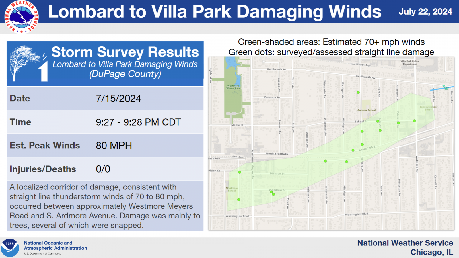
6.) Lombard to Villa Park Straight-Line Winds
|
(click on image to enlarge) |
|
Summary: A localized corridor of damage, consistent with straight-line thunderstorm winds of 70 to 80 mph, occurred between approximately Westmore Meyers Road and S. Ardmore Avenue. Damage was mainly to trees, several of which were snapped. |
7.) Northlake to Harwood Heights Straight-Line Winds
|
(click on image to enlarge) |
|
Summary: To the southeast of the Chicago-O'Hare tornado, an area of straight-line winds estimated between 70 and 80 mph led to widespread downed trees and tree limbs, as well as some damage to structures and power lines, from Northlake northeastward to Norridge and Harwood Heights, including across the southeastern portion of O'Hare Airport. |
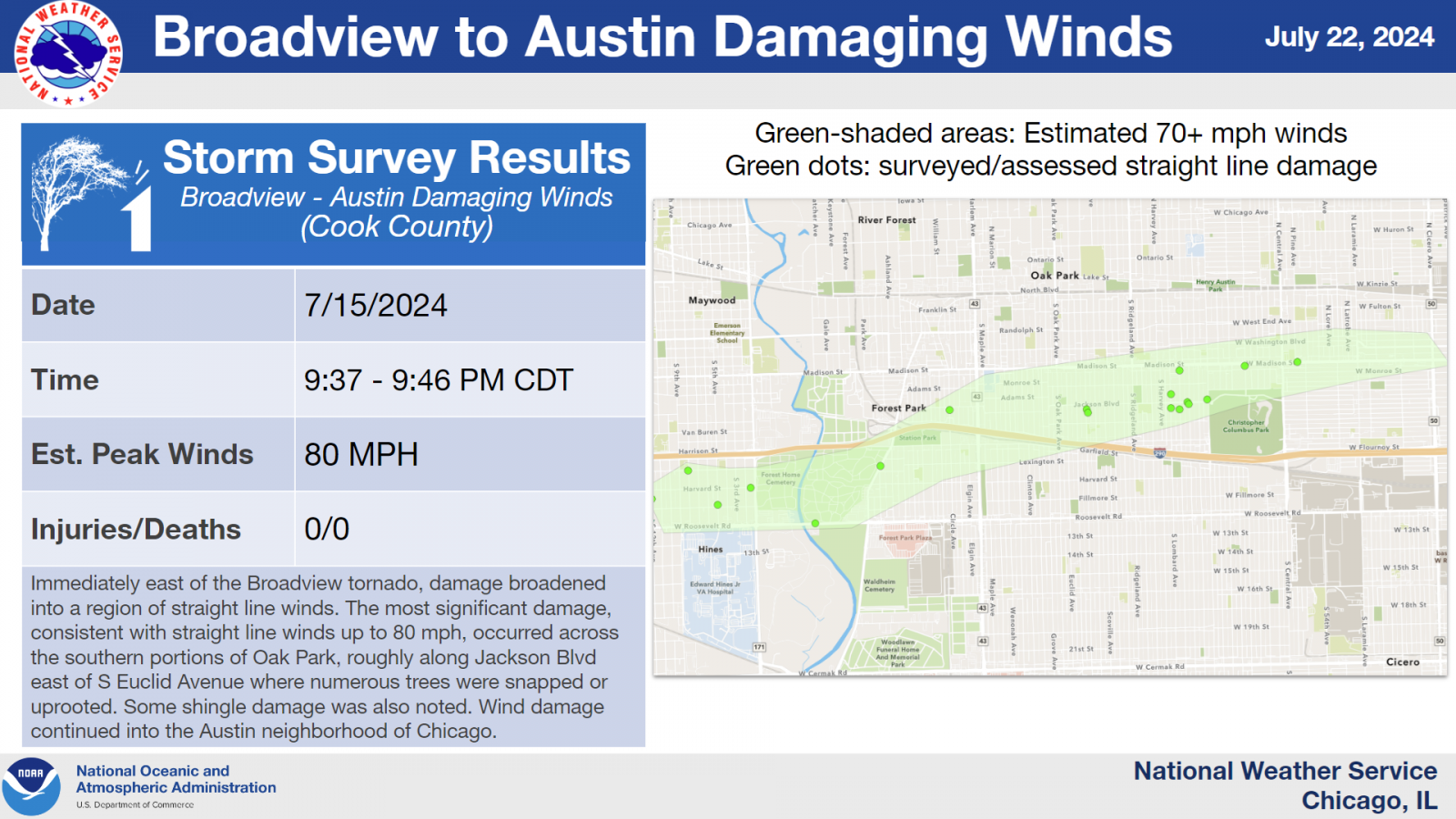
8.) Broadview to Austin Straight-Line Winds
|
(click on image to enlarge) |
|
Summary: Immediately east of the Broadview tornado's end point, damage broadened into a region of straight-line winds. The most significant damage, consistent with straight-line winds up to 80 mph, occurred across the southern portion of Oak Park, roughly along Jackson Boulevard east of S Euclid Avenue, where numerous trees were snapped or uprooted. Some shingle damage was also noted. Wind damage continued into the Austin community area of Chicago. |
9.) Justice to Bridgeview Straight-Line Winds
|
(click on image to enlarge) |
|
Summary: On the south side of the Justice tornado, an area of straight-line winds estimated between 70 and 80 mph downed tree limbs. Straight-line wind damage also continued beyond the tornado's end point into Bridgeview, though the tree damage there was less significant than it was in Justice. |
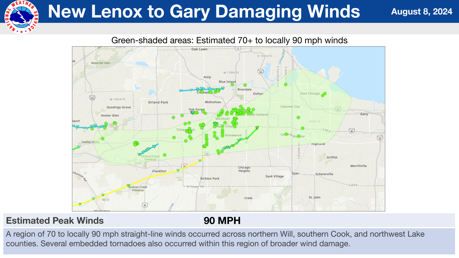
10.) New Lenox to Gary Straight-Line Winds
|
(click on image to enlarge) |
|
Summary: A region of 70 to locally 90 mph straight-line winds occurred across northern Will, southern Cook, and northwest Lake counties. Widespread damage to trees, power lines, and signs was noted across this corridor. Several embedded tornadoes also occurred within this region of broader wind damage. |
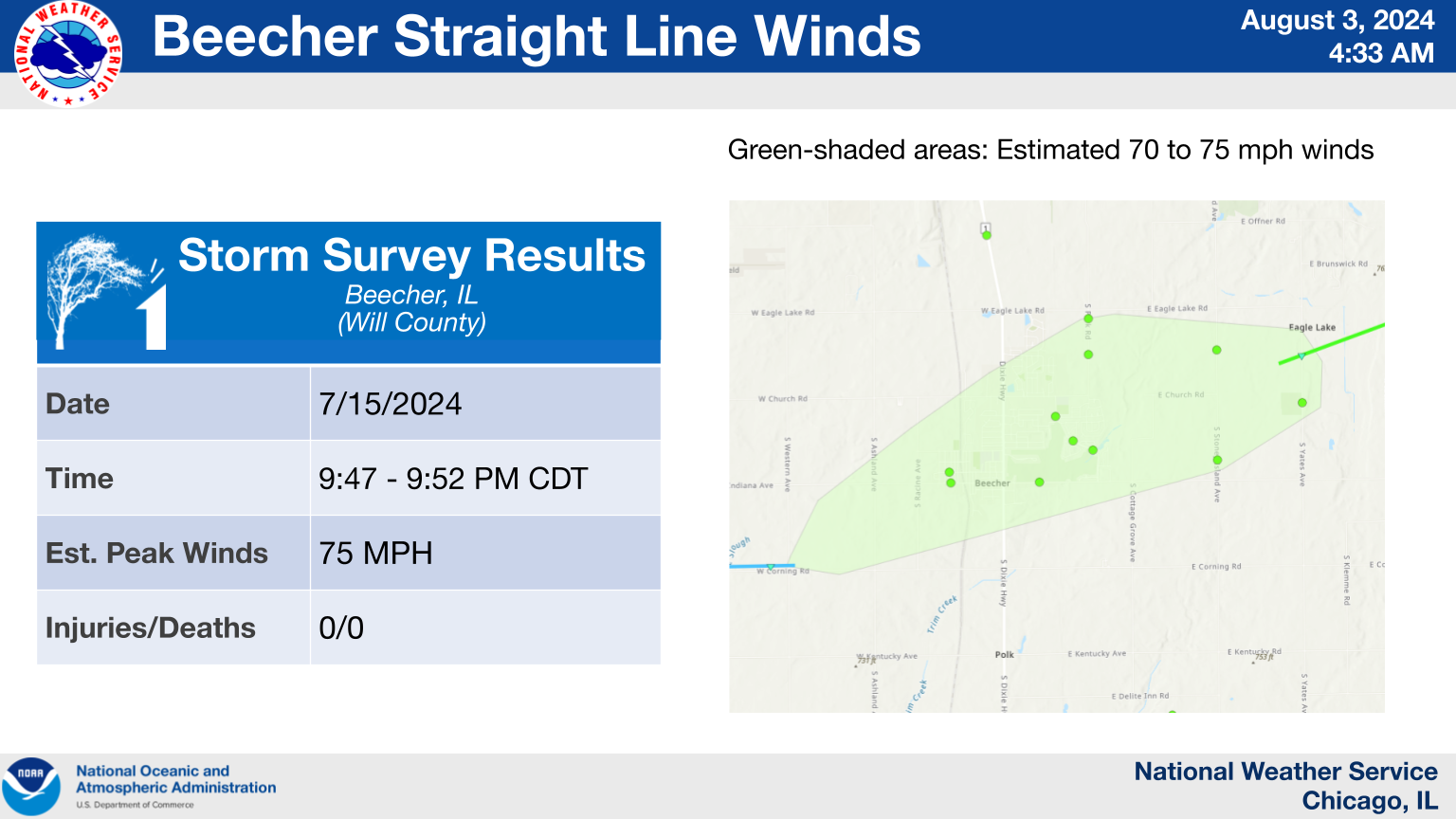
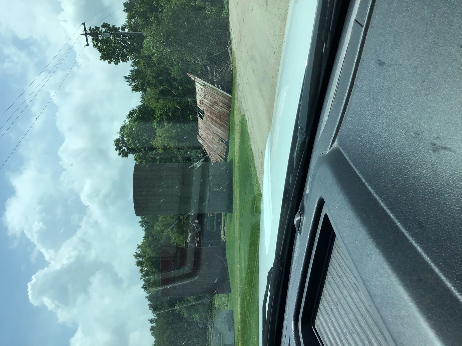
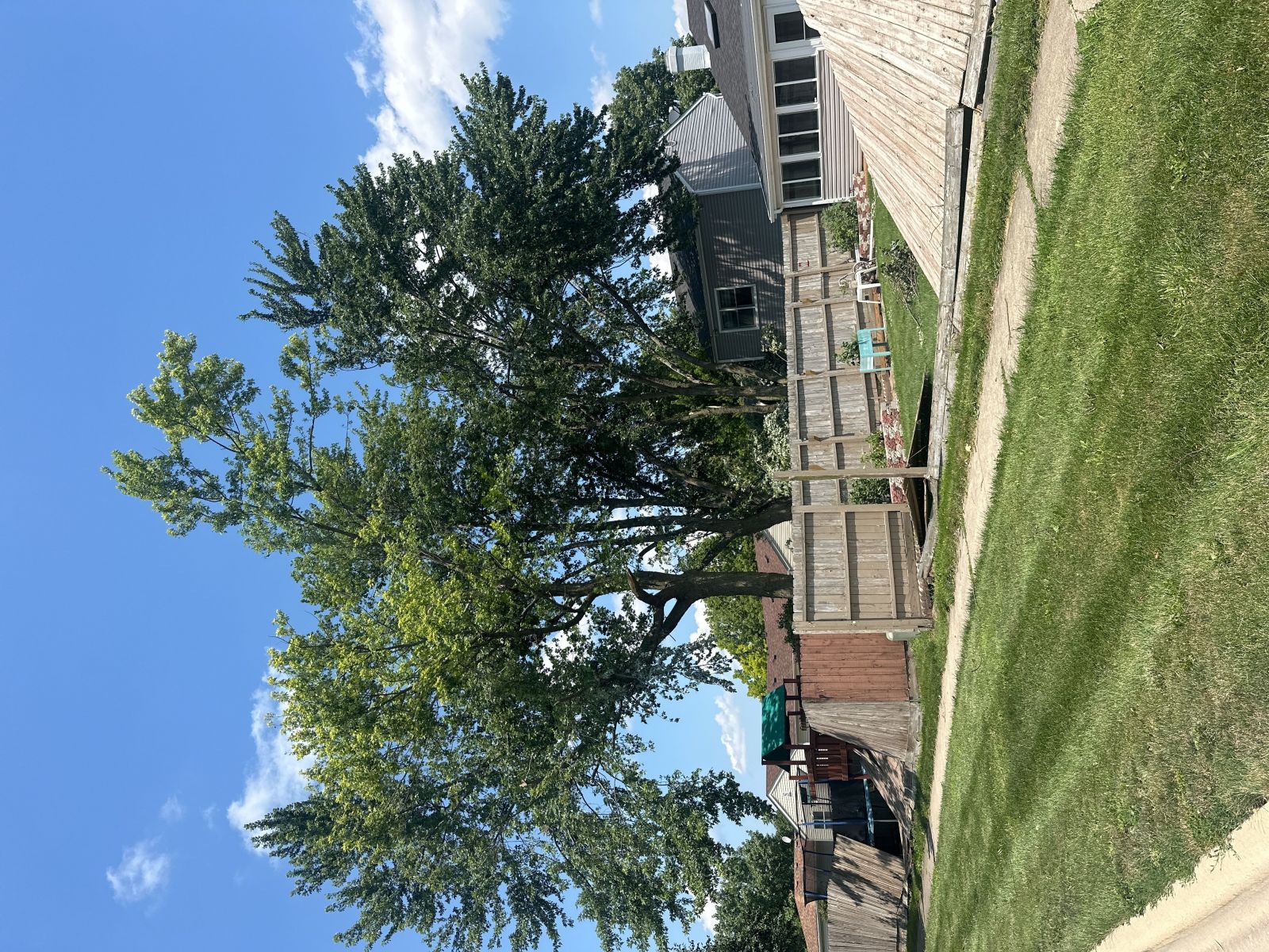
11.) Beecher Straight-Line Winds
|
(click on image to enlarge) |
|
Summary: A broad area of 70 to 75 mph straight-line winds started near the end of a tornado path southwest of Beecher and continued directly through Beecher, where widespread tree damage was observed, before another tornado spun up just east of Beecher. |
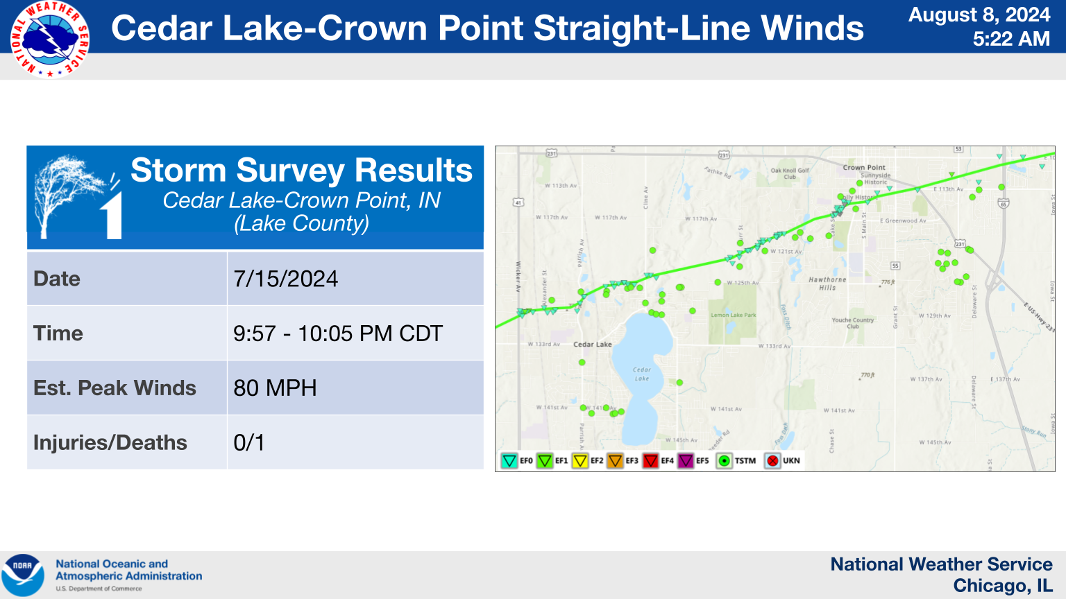
12.) Cedar Lake to Crown Point Straight-Line Winds
|
(click on image to enlarge) |
|
Summary: South of the Cedar Lake to Valparaiso tornado, a corridor of strong straight-line winds caused widespread tree damage across Cedar Lake and Crown Point. One fatality occurred in Cedar Lake after a large tree limb fell onto a house. |
13.) Lowell to Hebron Straight-Line Winds
|
(click on image to enlarge) |
|
Summary: A concentrated corridor of damage across Lowell was determined to have been caused by both straight-line winds and an EF-0 tornado. While the tornado ended near Evergreen Park, the corridor of straight-line wind damage continued east of Lowell into the Hebron area, where several trees were downed and some minor structural damage was noted. |
Storm Reports
|
Preliminary Storm Report Map |
For a listing of quality-controlled storm reports from this event in the NWS Chicago forecast area, click on the links below.
(Boone, Cook, DeKalb, DuPage, Ford, Grundy, Iroquois, Kane, Kankakee, Kendall, Lake, La Salle, Lee, Livingston, McHenry, Ogle, Will, and Winnebago)
(Benton, Jasper, Lake, Newton, and Porter)
Historical Context
With 32 tornadoes, the July 15, 2024 derecho was the most prolific tornado event to impact the NWS Chicago forecast area in recorded history. The previous record was 22 tornadoes in a single event, set by the June 30, 2014 and March 31, 2023 tornado outbreaks. When combined with the 9 tornadoes that occurred the night before (July 14th, 2024), there were 41 confirmed tornadoes within a 36-hour period across the NWS Chicago forecast area. In total, the July 15, 2024 tornado was responsible for 56 tornadoes across Iowa, Illinois, and Indiana.
Are tornado outbreaks becoming more common?
With several high profile and prolific tornado outbreaks occurring in our local area within the past few years, it is natural to wonder if tornadoes are becoming more common. When looking at a climatology of tornadoes across northern Illinois and northwestern Indiana over the past 10 to 20 years, the number of strong (EF-2+) tornadoes has remained relatively steady with an average of about 1 per year. However, the number of weak (EF-U, EF-0, or EF-1) tornadoes has been increasing. What may be responsible for the increase in weak tornadoes? There are a number of factors, as listed below.
1). Better understanding of the types of storms that produce tornadoes
Since the late 1900s, meteorologists have been gaining a better understanding of the types of storms that produce brief and weak tornadoes. Contrary to supercell thunderstorms, which are responsible for the majority of long-tracked, violent, and deadly tornadoes, the type of storm that often produces brief and weak tornadoes is known as a quasi-linear convective system (QLCS), or squall line. That is not to say that QLCS/squall line tornadoes are not dangerous. Rather, our understanding of how they form and the ways to detect them both in real-time and after a storm have dramatically improved. Perhaps unsurprisingly, some of the most prolific tornado events that occurred in the NWS Chicago forecast area were associated with squall lines.
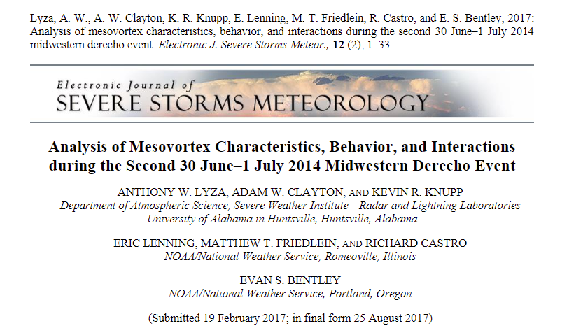 |
| Example article analyzing the characteristics of circulations that produced tornadoes during the June 30, 2014 localized tornado outbreak in northeastern Illinois and northwestern Indiana. Several staff members of NWS Chicago were co-authors of the article. Link to Article. |
2). Better capability to detect tornadoes
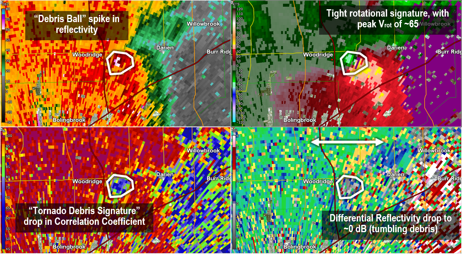
Over the past few decades, radar scanning strategies and resolution have dramatically improved the ability for meteorologists to anticipate and detect tornadoes before and while they are occurring, respectively. In the most aggressive scanning strategy, meteorologists have access to new scans at the lowest elevation in as few as 3 to 4 minutes. In addition, staff at NWS Chicago have access to data from FAA-owned and operated terminal Doppler radars TORD, TMDW, and TMKE, which can provide a new scan in as few as 60 seconds with a coverage area across most of the Chicago metropolitan area. Furthermore, the addition of dual-polarization capability to analyze the "shape" of what our radar is seeing can provide confirmation that a tornado is occurring by identifying lofted debris. As a result, NWS meteorologists sometimes know for a fact that a tornado occurred prior to receiving reports of damage! For these reasons, NWS meteorologists have a plethora of data at their fingertips to monitor and anticipate storm evolution, including detecting brief and weak tornadoes.
 |
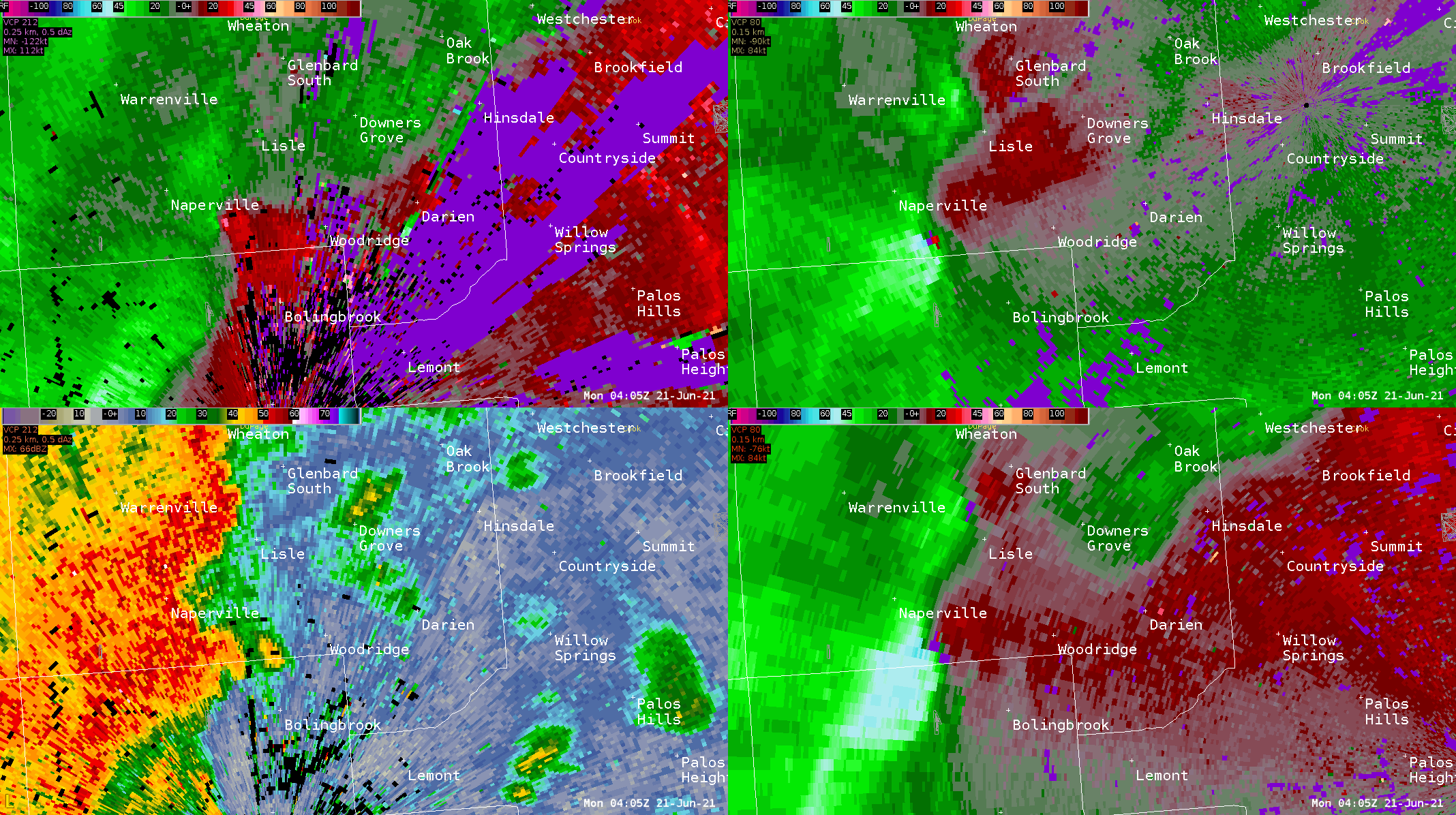 |
| Example of a "Tornado Debris Signature" using radar reflectivity, storm-relative velocity, correlation coefficient, and differential reflectivity, during the June 20, 2021 Naperville to Willow Springs EF-3 Tornado. | View of the Naperville to Willow Springs EF-3 tornado from KLOT (top left, bottom left), TORD (top right), and TMDW (bottom right), between 11:05 and 11:14 PM June 20, 2021. Note the increased temporal resolution provided by TORD and TMDW. |
3). Better methods to detect brief damage paths and collect damage reports
With the rise of social media in the past two decades came a corresponding improved ability to interact favorably with the public. Our social media channels are often a go-to resource for us to collect reports and photos of storm damage, which can then be compared to radar data to assess whether an investigation of if a tornado occurred is needed. It is rare for notable storm damage that occurs in populated areas to go unreported to the NWS in some shape or form. Hence, it is easier to locate damage produced by brief and weak tornadoes simply through more reliable and frequent reports. In addition, NWS meteorologists have access to high resolution satellite data that is collected after severe weather events that can be used to identify potential tornado damage paths, particularly through agricultural and rural areas. After identifying potential damage paths, NWS meteorologists often work with local Emergency Management officials to confirm that damage indeed exists, and then compare the damage path with radar data to determine if a tornado occurred. The use of drone footage is also incredibly helpful to help confirm narrow or short paths of damage in agricultural or rural areas.
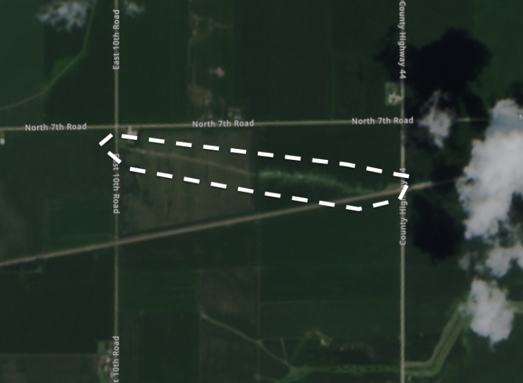 |
| Example damage path through an agricultural field in rural La Salle County, IL, produced by a tornado during the early morning hours of July 15, 2024 (by a line of storms the night before the derecho). Imagery contains modified Copernicus Sentinel2 data 2024. |
Putting it all together...
In all, it is easier to identify, detect, and confirm brief and weak tornadoes today compared to decades of the past. For this reason, it is possible that the number of brief and weak tornadoes that occurred in prior decades was undercounted, and we are now simply recording a more accurate number of tornadoes that occur in our region. With that said, the derecho on July 15, 2024 was still an impressive and prolific tornado event as it remains rare for an individual storm event to produce more than 50 tornadoes on a region-wide basis.
How often do derechos occur?
Derechos are relatively common across northern Illinois and northwestern Indiana, with at least 10 derechos every decade (roughly about 1 derecho every year). More significant derechos, such as the one that occurred on July 15, 2024, occur less frequently.
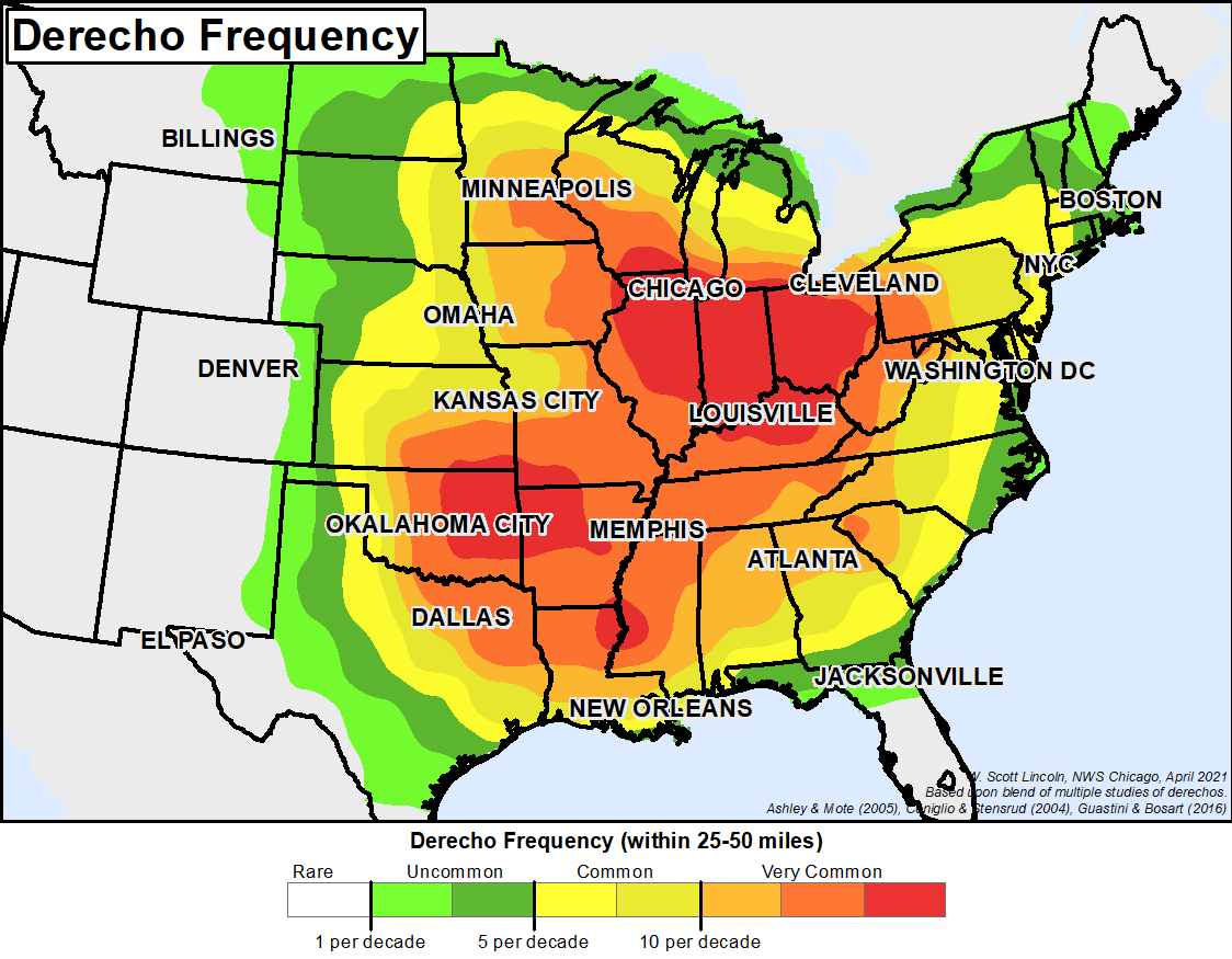 |
| Relative frequency of derecho events across the eastern contiguous United States. |
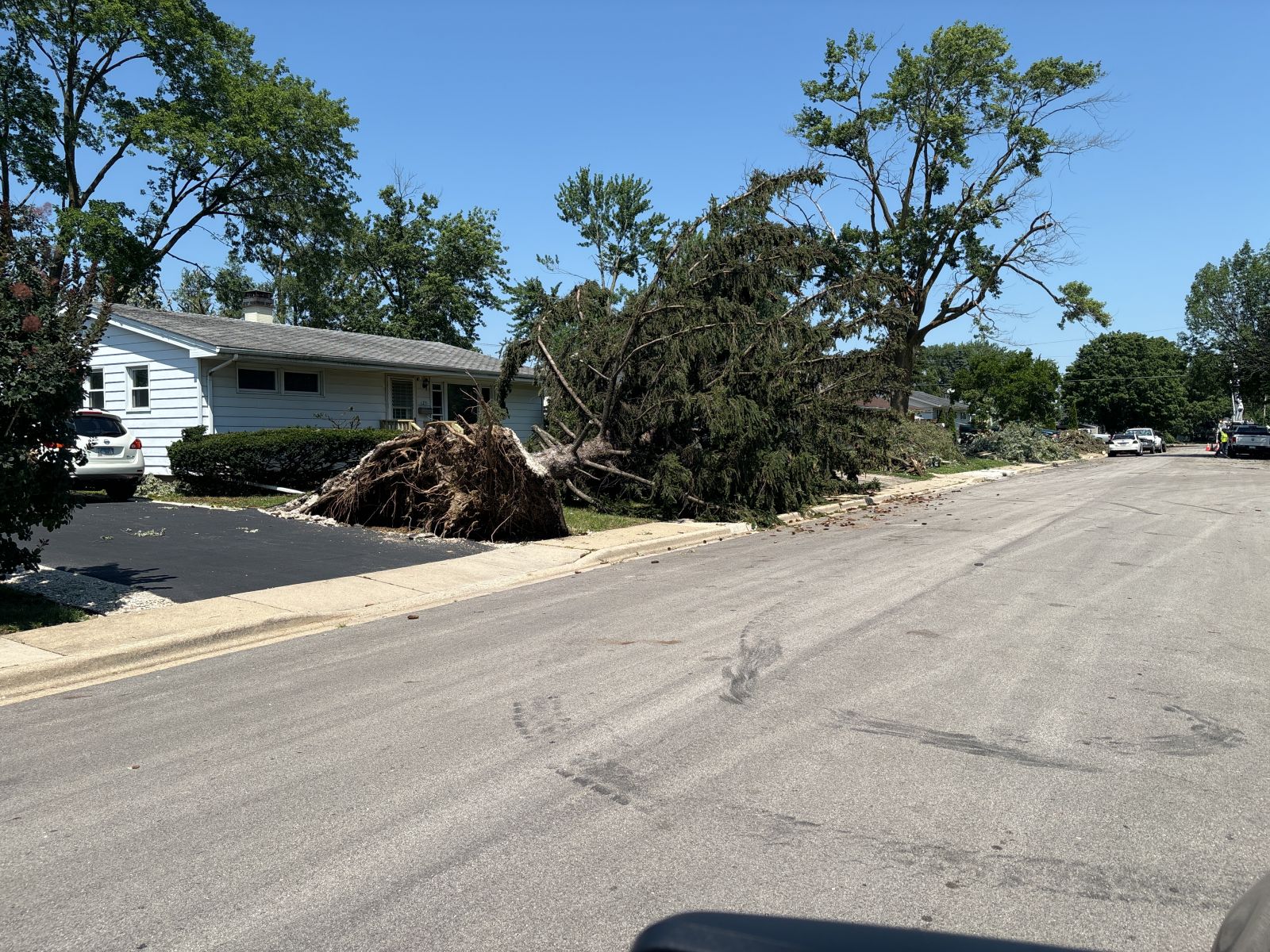
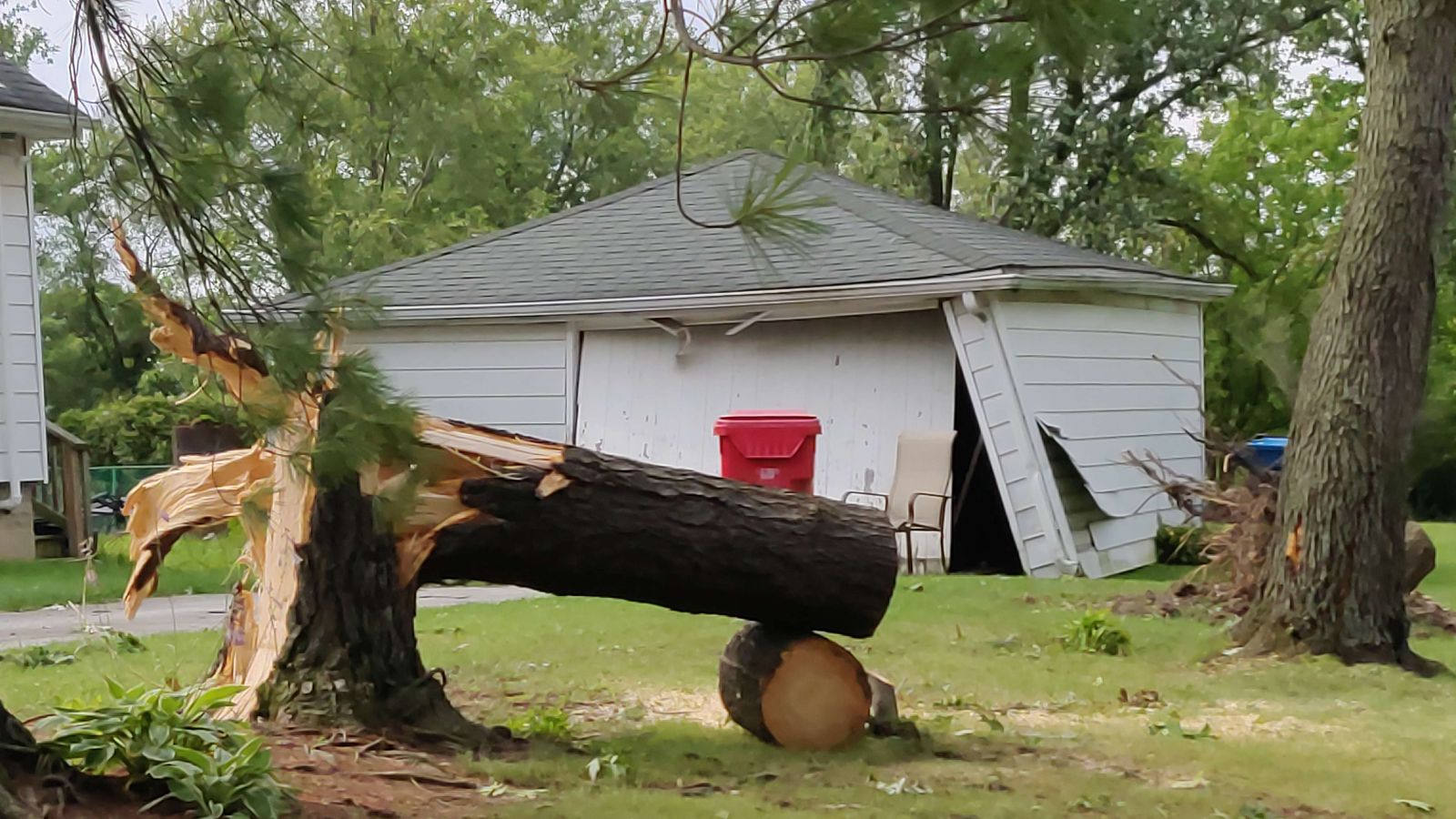
Photos
 |
|
|
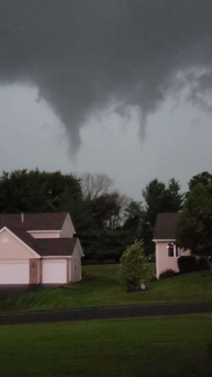
| The Byron, IL tornado. Photo courtesy of Michael Noga. | Wind damage in southern Winnebago County, IL. Photo from NWS damage survey. | Tornado damage in Aurora, IL. Photo from NWS damage survey. |
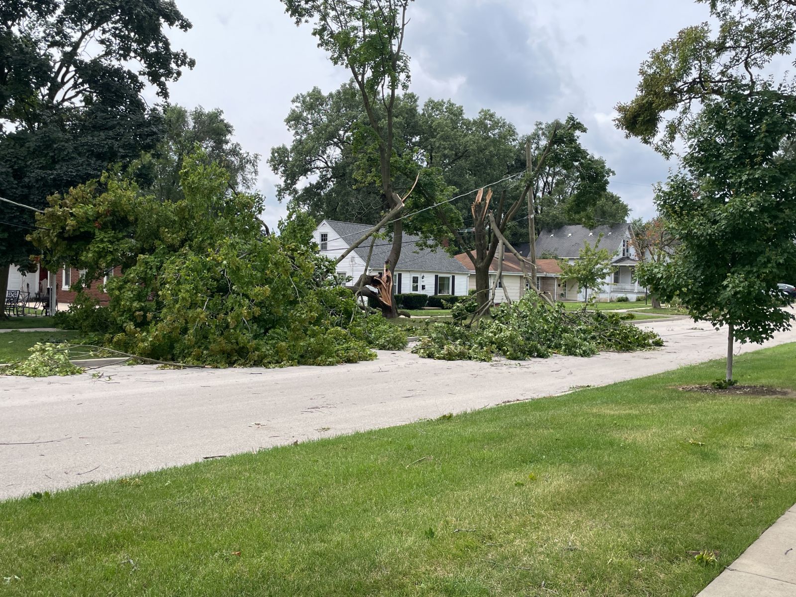
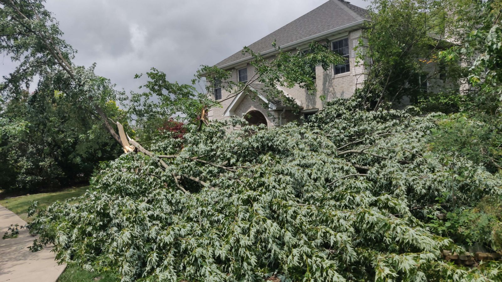
|
|
|
|
| Tornado damage in Oswego, IL. Photo from NWS damage survey. | Tornado damage in Naperville, IL. Photo from NWS damage survey. | Tornado damage in Joliet, IL. Photo from NWS damage survey. |
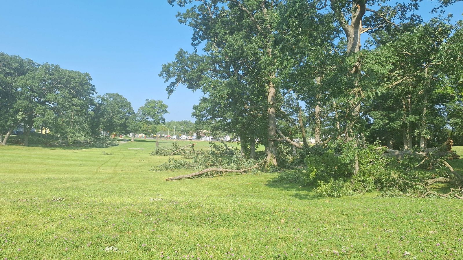
 |
 |
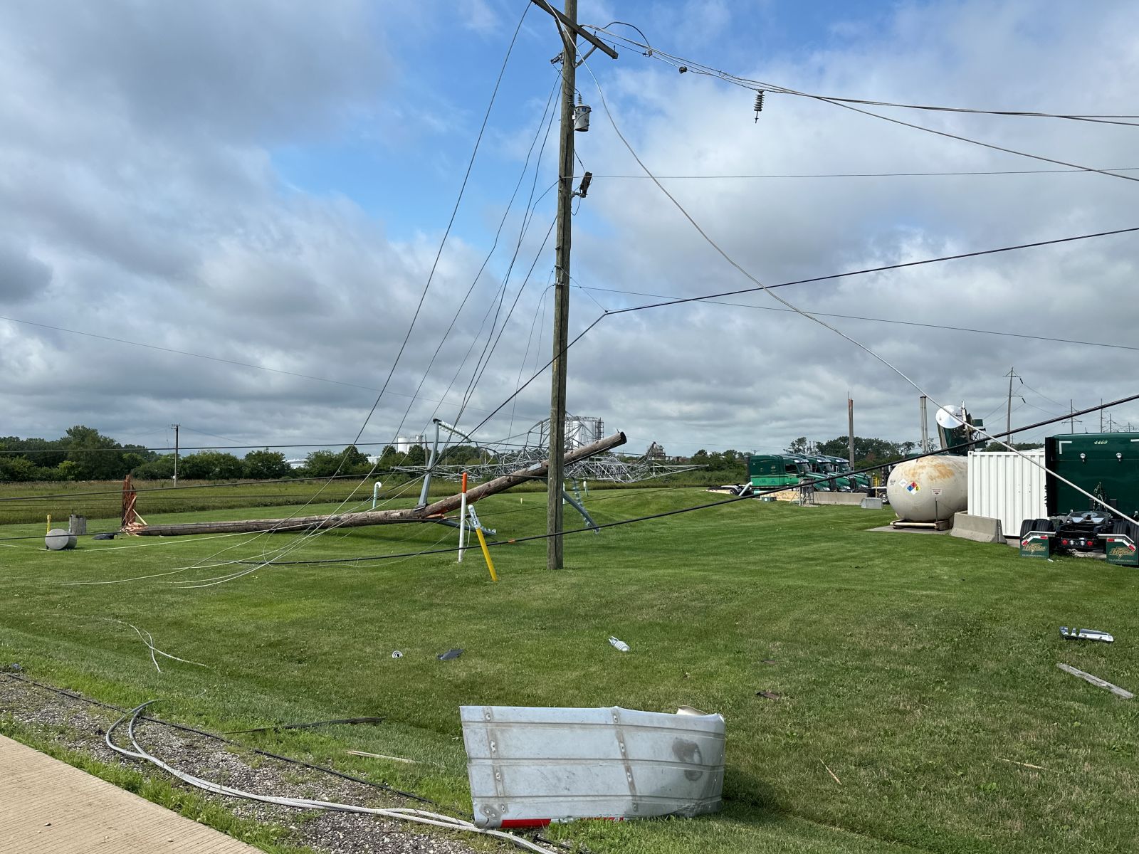 |
| Tornado damage in Joliet, IL. Photo from NWS damage survey. | Tornado damage in Lockport, IL. Photo from NWS damage survey. | Tornado damage near Channahon, IL. Photo from NWS damage survey. |
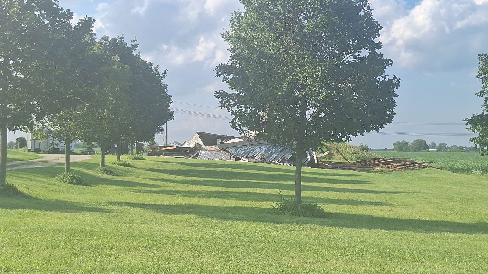
|
|
|
|
| Tornado damage near Channahon, IL. Photo from NWS damage survey. | Tornado damage in Lombard, IL. Photo from NWS damage survey. | Tornado damage in Glen Ellyn, IL. Photo from NWS damage survey. |
 |
 |
 |
| Tornado damage near Peotone, IL. Photo from NWS damage survey. | Tornado damage in Oak Forest, IL. Photo from NWS damage survey. | Tornado damage in Country Club Hills, IL. Photo from NWS damage survey. |
 |
 |
 |
| Tornado damage in Justice, IL. Photo from NWS damage survey. | Tornado damage in Marquette Park, Chicago, IL. Photo from NWS damage survey. | Tornado damage in the Chicago Lawn community area of Chicago. Photo from NWS damage survey. |
 |
 |
 |
| Tornado damage in the Near West Side community area of Chicago. Photo from NWS damage survey. | Tornado damage in the Near West Side community area of Chicago. Photo from NWS damage survey. | Tornado damage in the Near West Side community area of Chicago. Photo from NWS damage survey. |
 |
 |
 |
| Tornado damage in Cedar Lake, IN. Photo from NWS damage survey. | Tornado damage in Crown Point, IN. Photo from NWS damage survey. | Tornado damage in Lowell, IN. Photo from NWS damage survey. |
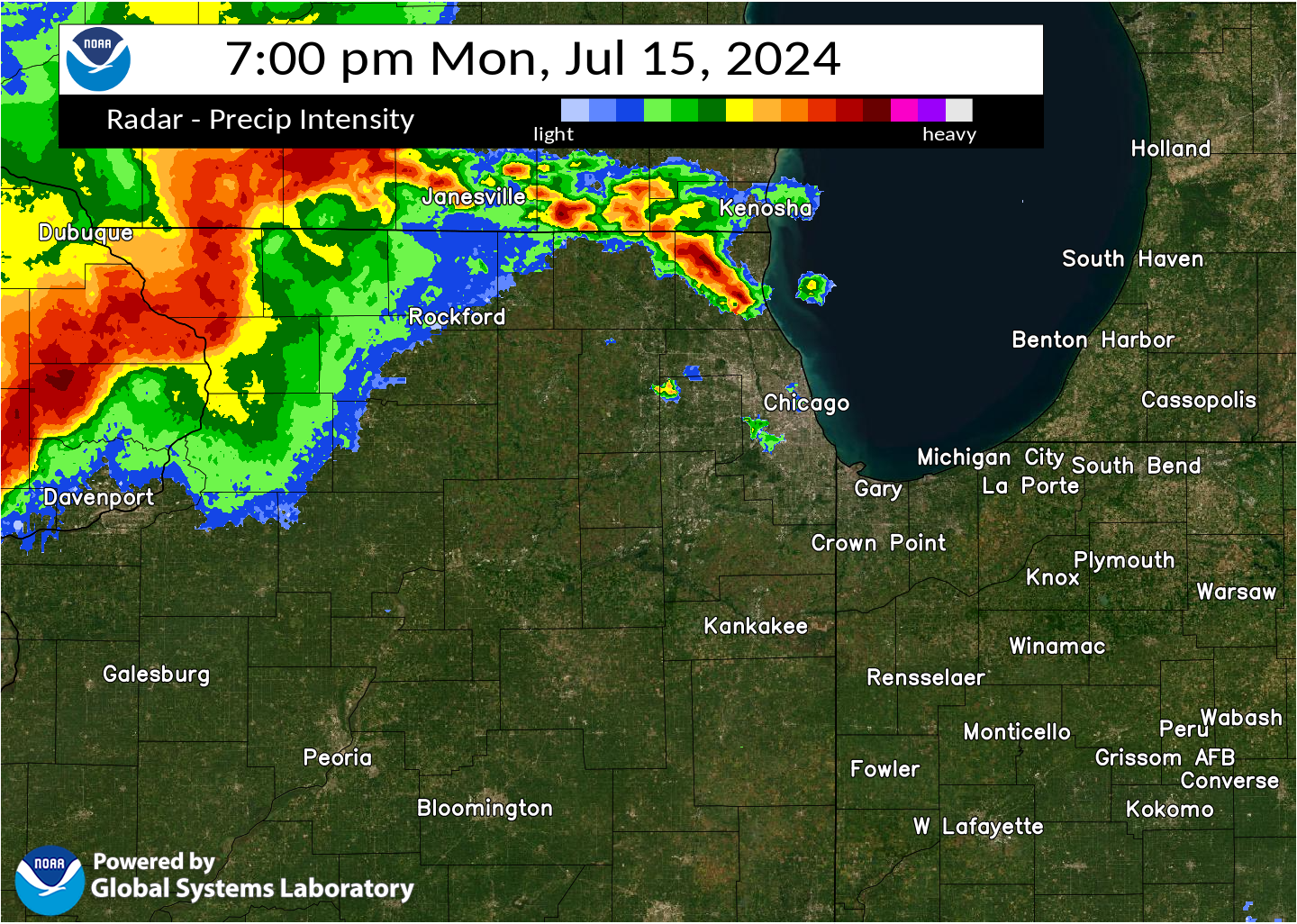
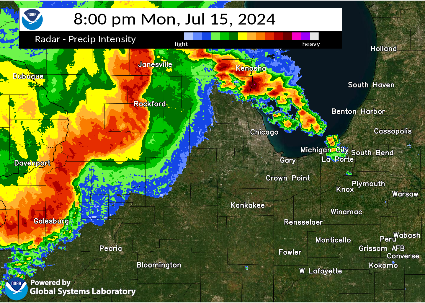
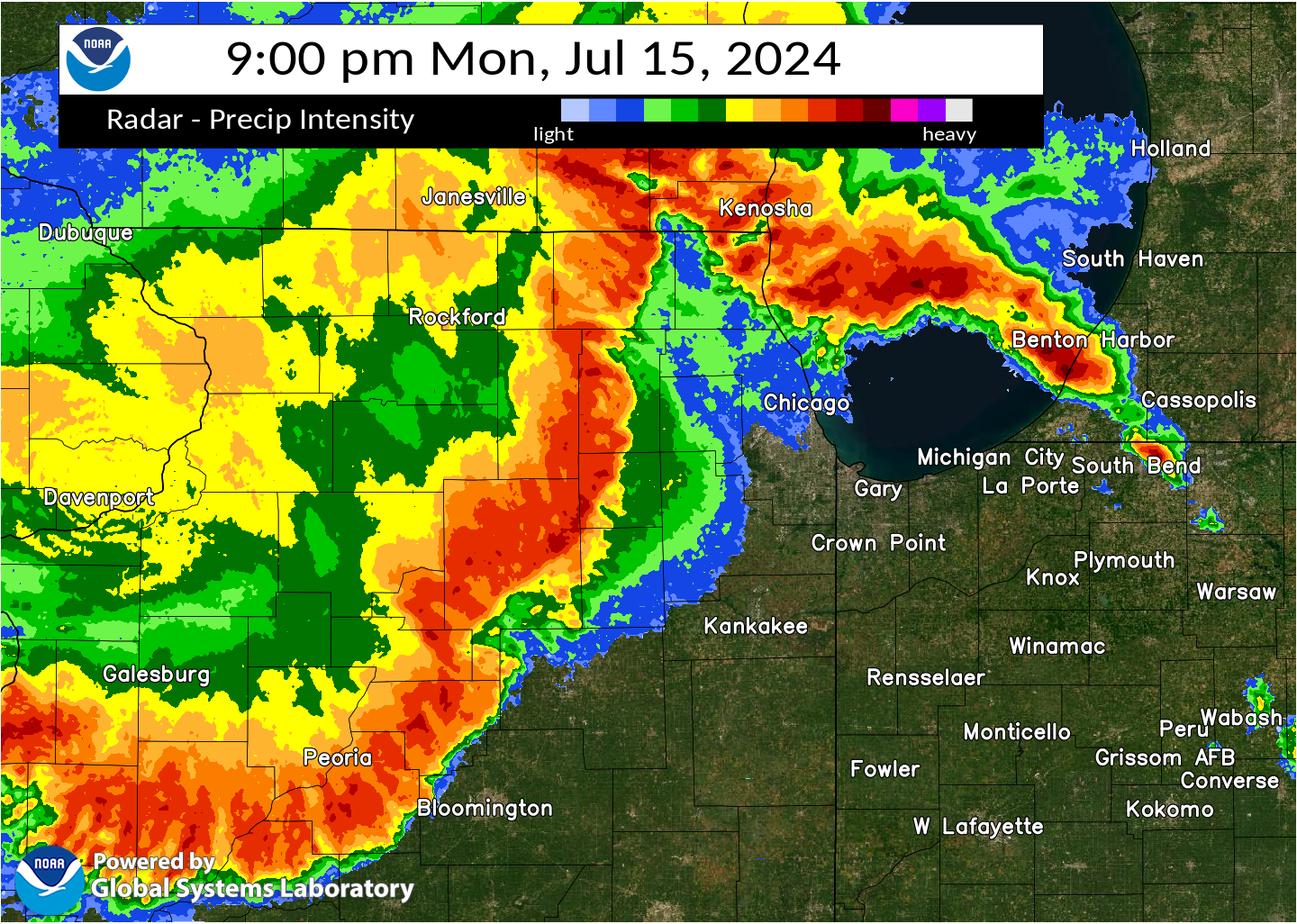
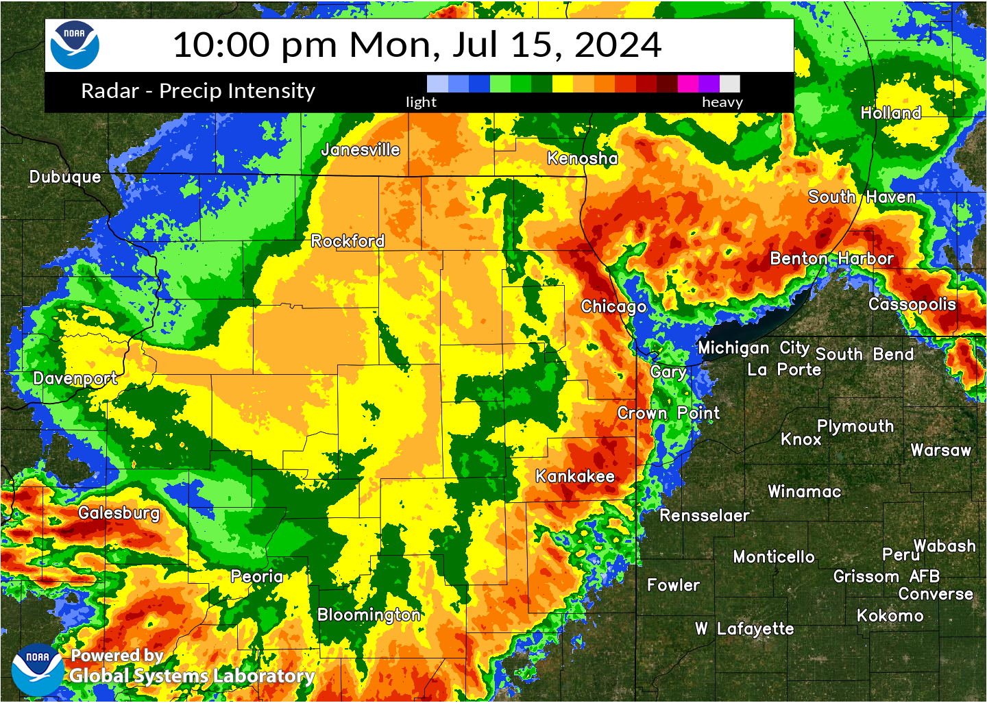
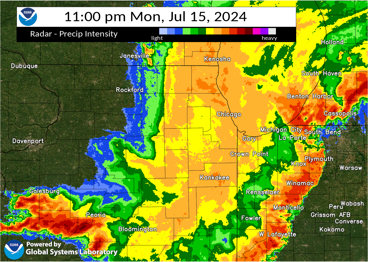
Radar
Meteorology and Environment
From July 13 to July 15, there were five separate episodes of thunderstorms across northern Illinois and northwestern Indiana, all within the span of around 60 hours. Indeed, the July 15, 2024 derecho occurred on the heels of significant flash flooding in Rockford from July 13 to 14th, and a severe thunderstorm event that occurred during the evening of July 14th. The episodic thunderstorms were part of a quintessential summertime pattern called "The Ring of Fire," during which rounds of thunderstorms parade around the perimeter of a "dome" of hot air. The pattern occurs nearly every summer, though with varying degrees of severity and cadence, depending on the specific amount of instability available and means for thunderstorm initiation.
With regard to July 15 specifically, there was a copious amount of moisture-laden instability available to support explosive thunderstorms. In addition, a strong upper-level wave moved into the Great Lakes, leading to a large area of deep-layer shear over and in a deep pool of instability. Taken together, there was a somewhat rare combination of strong shear and extreme instability, which supported the development of an intense, well-organized line of thunderstorms called a derecho.
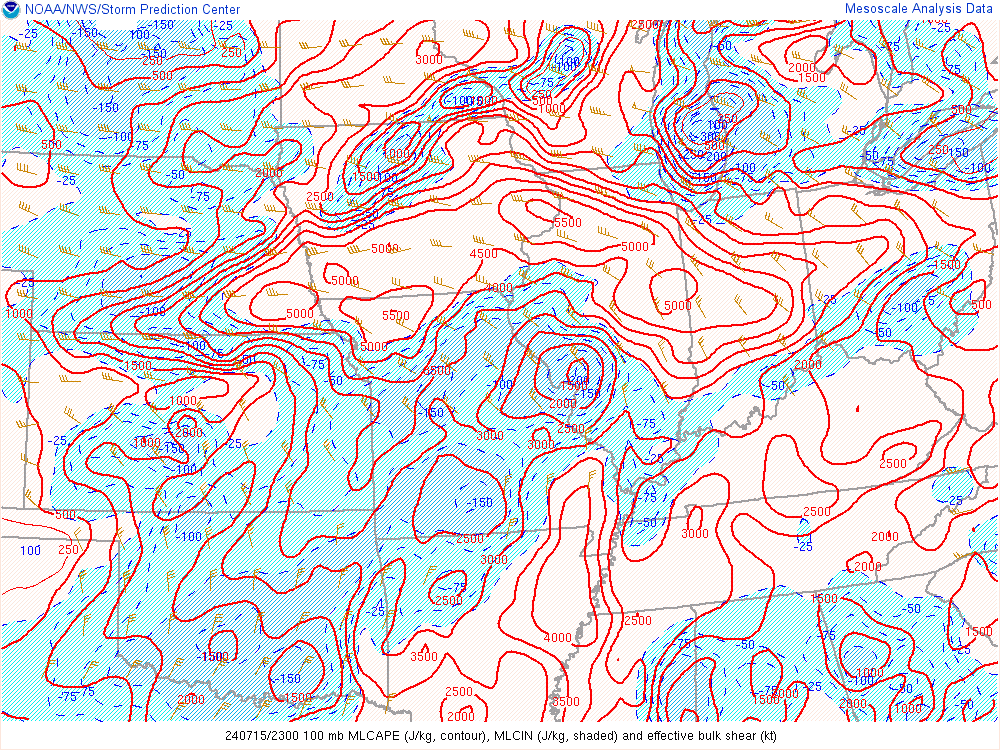
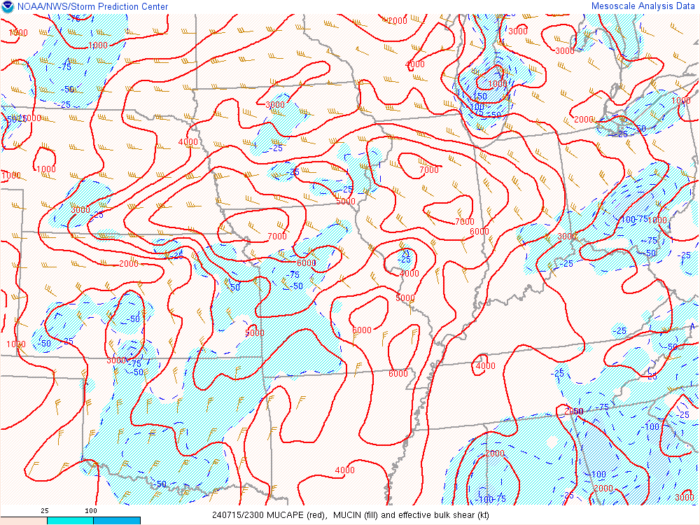
The images below feature some of the key ingredients for severe weather during the evening of July 15.
 |
 |
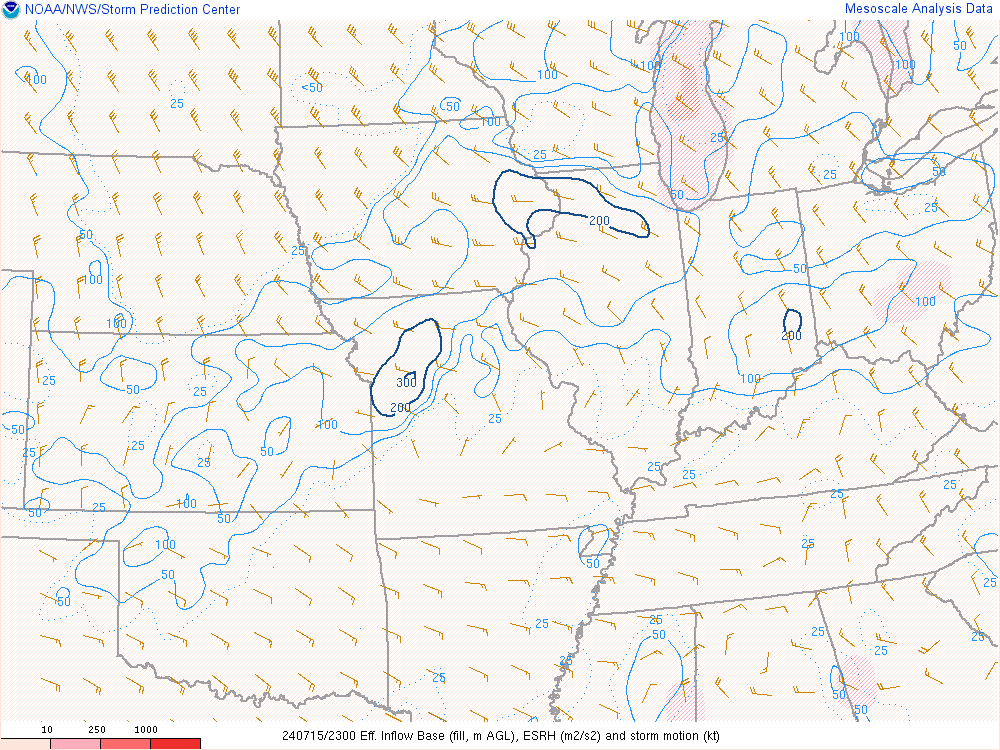 |
| 6 PM Mixed-layer CAPE and deep layer shear. | 6 PM Most-unstable CAPE and deep layer shear. | 6 PM Effective storm-relative helicity. |
 |
 |
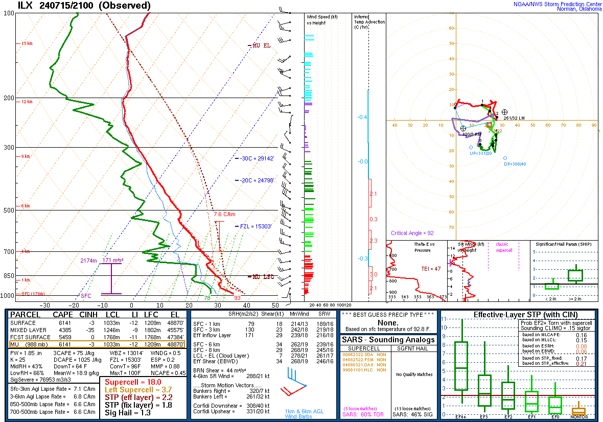 |
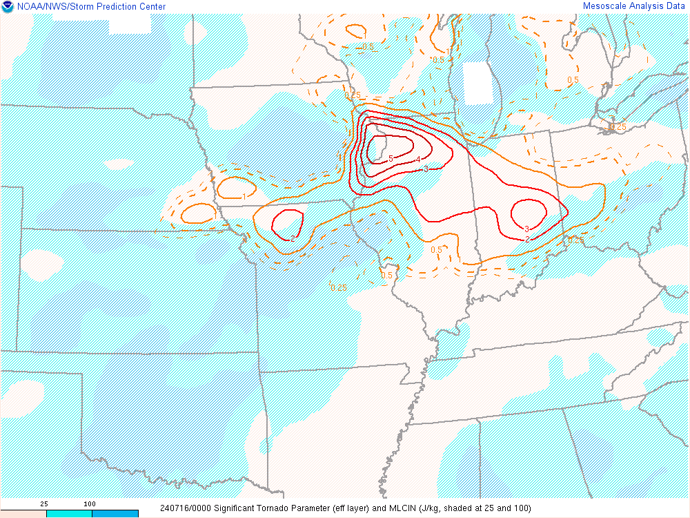
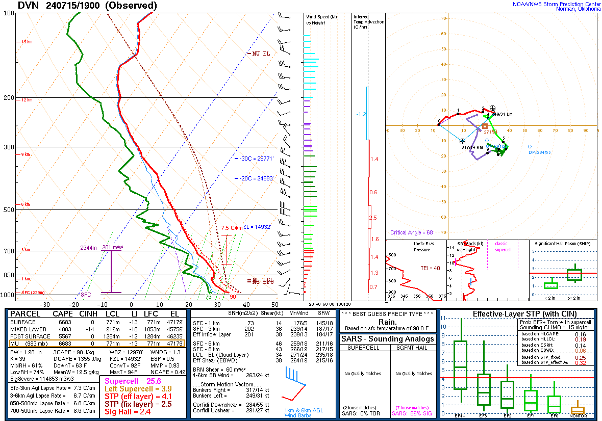
| 8 PM Effective "Significant Tornado Parameter" | 2 PM special sounding from Davenport/Quad Cities, Iowa. | 4 PM special sounding from Lincoln, Illinois. |
 |
Media use of NWS Web News Stories is encouraged! Please acknowledge the NWS as the source of any news information accessed from this site. Additional recaps can be found on the NWS Chicago Past Events Page |
|


.png)
.png)
.png)
.png)
.png)


