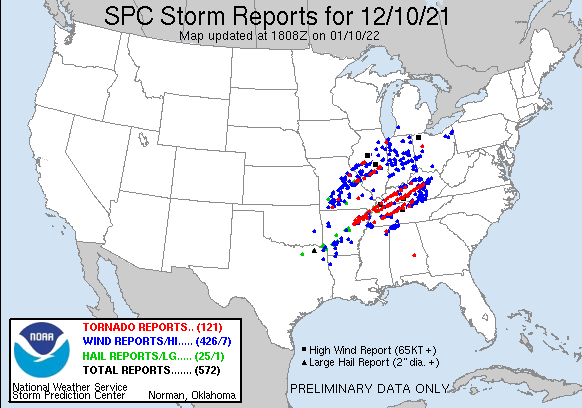
Overview
|
National Summary |
Local Summary |
Storm Reports
 |
| Map & List of Severe Thunderstorm Reports |
PRELIMINARY LOCAL STORM REPORT...SUMMARY
NATIONAL WEATHER SERVICE CHICAGO IL
1221 AM CST SUN DEC 12 2021

..TIME...   ...EVENT...      ...CITY LOCATION...     ...LAT.LON...
..DATE...   ....MAG....      ..COUNTY LOCATION..ST.. ...SOURCE....
            ..REMARKS..

0915 PM     TSTM WND GST     3 NNE PONTIAC           40.92N 88.62W
12/10/2021  M58 MPH          LIVINGSTON         IL   AWOS

            AWOS STATION KPNT PONTIAC AIRPORT.

0927 PM     TSTM WND DMG     1 S MINOOKA             41.42N 88.27W
12/10/2021                   GRUNDY             IL   PUBLIC

            LARGE TREE DOWNED. TIME ESTIMATED.

0930 PM     TSTM WND DMG     GIBSON CITY             40.47N 88.38W
12/10/2021                   FORD               IL   LAW ENFORCEMENT

            ROOF PARTIALLY BLOWN OFF A RESIDENTIAL
            BUILDING AND A COUPLE TREES DOWNED.

0934 PM     TSTM WND DMG     CHEBANSE                41.00N 87.91W
12/10/2021                   KANKAKEE           IL   FIRE DEPT/RESCUE

            TWO SEMIS BLOWN ON TO THEIR SIDES ON I-57
            NEAR MILE MARKER 302. TIME ESTIMATED BASED
            ON RADAR.

0935 PM     TSTM WND GST     1 WSW NWS CHICAGO-ROMEO 41.60N 88.10W
12/10/2021  M54 MPH          WILL               IL   AWOS

            AWOS STATION KLOT ROMEOVILLE - LEWIS
            AIRPORT.

0948 PM     TSTM WND DMG     DONOVAN                 40.88N 87.62W
12/10/2021                   IROQUOIS           IL   LAW ENFORCEMENT

            COUPLE LARGE TREES DOWNED ON THE OUTSKIRTS
            OF TOWN.

1000 PM     TSTM WND GST     PEOTONE                 41.33N 87.79W
12/10/2021  M50 MPH          WILL               IL   MESONET

            MESONET STATION CW7762 PEOTONE.

1005 PM     TORNADO          3 NNW CEDAR LAKE        41.41N 87.46W
12/10/2021                   LAKE               IN   NWS STORM SURVEY

            NWS STORM SURVEY FOUND DAMAGE CONSISTENT
            WITH AN EF-0 TORNADO WITH ESTIMATED PEAK
            WIND SPEEDS OF 85 MPH AND A PATH LENGTH OF
            4.8 MILES FROM UNINCORPORATED CEDAR LAKE
            INTO THE NORTH SIDE OF CROWN POINT.

1017 PM     TSTM WND GST     DEMOTTE                 41.19N 87.20W
12/10/2021  M72 MPH          JASPER             IN   TRAINED SPOTTER


1023 PM     TSTM WND DMG     1 SSW OGDEN DUNES       41.61N 87.20W
12/10/2021                   PORTER             IN   PUBLIC

            TREES AND POWER LINES DOWN NEAR STAGE COACH
            ROAD. TIME ESTIMATED BY RADAR.

1029 PM     TSTM WND GST     4 W RENSSELAER          40.94N 87.22W
12/10/2021  M65 MPH          JASPER             IN   MESONET

            MESONET STATION IN005 2.7 W COLLEGEVILLE
            (INDOT).

1035 PM     TSTM WND GST     2 WNW RENSSELAER        40.95N 87.18W
12/10/2021  M69 MPH          JASPER             IN   AWOS

            AWOS STATION KRZL RENSSELAER AIRPORT.

1038 PM     TSTM WND DMG     WHEATFIELD              41.19N 87.05W
12/10/2021                   JASPER             IN   LAW ENFORCEMENT

            COUPLE LARGE TREES DOWNED IN THE AREA, AS
            WELL AS SEVERAL DOWNED MEDIUM TO LARGE TREES
            SCATTERED ABOUT THE COUNTY.

1045 PM     TSTM WND GST     2 N KOUTS               41.34N 87.02W
12/10/2021  M54 MPH          PORTER             IN   MESONET

            MESONET STATION FW9001 KOUTS.

1056 PM     TSTM WND GST     2 ENE REMINGTON         40.77N 87.12W
12/10/2021  M60 MPH          JASPER             IN   MESONET

            MESONET STATION IN048 1.7 E REMINGTON
            (INDOT).

0335 AM     NON-TSTM WND GST 2 SSW ROCHELLE          41.89N 89.08W
12/11/2021  M52 MPH          OGLE               IL   AWOS

            AWOS STATION KRPJ ROCHELLE AIRPORT.

0400 AM     NON-TSTM WND GST 1 E WOODLAWN - CHICAGO  41.78N 87.57W
12/11/2021  M57 MPH          COOK               IL   MESONET

            MESONET STATION JAKI2 1 N SOUTH SHORE -
            CHICAGO.

0400 AM     NON-TSTM WND GST 1 E WOODLAWN - CHICAGO  41.78N 87.57W
12/11/2021  M57 MPH          COOK               IL   MESONET

            MESONET STATION JAKI2 1 N SOUTH SHORE -
            CHICAGO.

0446 AM     NON-TSTM WND GST ROCKFORD AIRPORT        42.20N 89.10W
12/11/2021  M54 MPH          WINNEBAGO          IL   ASOS

            ASOS STATION KRFD ROCKFORD AIRPORT.

0448 AM     NON-TSTM WND GST MIDWAY AIRPORT          41.78N 87.76W
12/11/2021  M64 MPH          COOK               IL   ASOS

            ASOS STATION KMDW CHICAGO MIDWAY.

0450 AM     NON-TSTM WND GST 1 SW BEACH PARK         42.42N 87.87W
12/11/2021  M54 MPH          LAKE               IL   ASOS

            ASOS STATION KUGN WAUKEGAN AIRPORT.

0450 AM     NON-TSTM WND GST 5 ENE HERBERT           42.18N 88.70W
12/11/2021  M64 MPH          MCHENRY            IL   MESONET

            MESONET STATION IMC01 HERBERT 5 ENE (MCHENRY
            DOT).

0450 AM     NON-TSTM WND GST 1 NW ROCHELLE           41.94N 89.08W
12/11/2021  M56 MPH          OGLE               IL   MESONET

            MESONET STATION CW8255 ROCHELLE.

0452 AM     NON-TSTM WND GST 2 W SUGAR GROVE         41.77N 88.48W
12/11/2021  M56 MPH          KANE               IL   ASOS

            ASOS STATION KARR SUGAR GROVE - AURORA ARPT.

0453 AM     NON-TSTM WND GST MIDWAY AIRPORT          41.78N 87.76W
12/11/2021  M64 MPH          COOK               IL   ASOS

            ASOS STATION KMDW CHICAGO MIDWAY.

0500 AM     NON-TSTM WND GST 2 E WAUKEGAN            42.36N 87.81W
12/11/2021  M48 MPH          LMZ740             IL   MESONET

            MESONET STATION WHRI2 WAUKEGAN HARBOR.

0515 AM     NON-TSTM WND GST 2 NW PERU               41.35N 89.15W
12/11/2021  M53 MPH          LA SALLE           IL   AWOS

            AWOS STATION KVYS PERU AIRPORT.

0515 AM     NON-TSTM WND DMG WESTCHESTER             41.85N 87.89W
12/11/2021                   COOK               IL   BROADCAST MEDIA

            LARGE TREE DOWNED ON VEHICLE. TIME
            ESTIMATED.

0516 AM     NON-TSTM WND GST ROSEMONT                41.99N 87.87W
12/11/2021  M55 MPH          COOK               IL   MESONET

            MESONET STATION EW1098 ROSEMONT.

0516 AM     NON-TSTM WND GST DUPAGE AIRPORT          41.92N 88.25W
12/11/2021  M60 MPH          DUPAGE             IL   ASOS

            ASOS STATION KDPA WEST CHICAGO - DUPAGE
            ARPT.

0520 AM     NON-TSTM WND GST OHARE AIRPORT           41.98N 87.90W
12/11/2021  M59 MPH          COOK               IL   ASOS

            ASOS STATION KORD CHICAGO OHARE.

0538 AM     NON-TSTM WND GST 2 SE WHEELING           42.12N 87.90W
12/11/2021  M53 MPH          COOK               IL   ASOS

            ASOS STATION KPWK WHEELING - CHICAGO EXEC.
            ARPT.

0602 AM     NON-TSTM WND GST 1 NE MONTROSE HARBOR    41.97N 87.63W
12/11/2021  M55 MPH          LMZ741             IL   MESONET

            MESONET STATION XMTB MONTROSE BEACH LIGHT.

0656 AM     NON-TSTM WND GST KANKAKEE AIRPORT        41.07N 87.85W
12/11/2021  M51 MPH          KANKAKEE           IL   AWOS

            AWOS STATION KIKK KANKAKEE AIRPORT.
Cedar Lake to Crown Point, IN Tornado
An NWS storm survey confirmed an EF-0 tornado with estimated maximum wind speeds from unincorporated Cedar Lake to northern portions of Crown Point.
 |
 |
| Tornado info and track. | Terminal Doppler Weather Radar (TDWR) 0.3° velocity data from tORD during the 9:44 -10:15 P.M. CST time window. This shows a developing circulation as the storms approach and cross the Illinois/Indiana state line. NWS warnings are also overlaid. |
Public Information Statement
National Weather Service Chicago IL
607 PM CST Sat Dec 11 2021 /707 PM EST Sat Dec 11 2021/

...NWS Damage Survey for December 10, 2021 Tornado Event...

Overview...

Scattered severe thunderstorms developed in the mid evening over
central Illinois and then tracked quickly northeastward across
eastern Illinois into northwest Indiana. Several of these cells
exhibited rotation, one of them tracking from eastern Will County
into western Lake County Indiana and producing a short-lived
tornado from unincorporated Cedar Lake into the north side of
Crown Point.

.Cedar Lake to Crown Point, IN Tornado...

Rating:                 EF-0
Estimated Peak Wind:    75-85 mph
Path Length /statute/:  4.8 miles
Path Width /maximum/:   100 yards
Fatalities:             0
Injuries:               0

Start Date:             12/10/2021
Start Time:             10:05 PM CST
Start Location:         3 NNW Cedar Lake / Lake County / IN
Start Lat/Lon:          41.41 / -87.46

End Date:               12/10/2021
End Time:               10:10 PM CST
End Location:           1 NNW Crown Point / Lake County / IN
End Lat/Lon:            41.43 / -87.37

Survey Summary:
This fast moving tornado caused primarily tree damage along its
nearly five mile path, with numerous snapped tree limbs and
several trees downed. One power pole was downed. In addition,
scattered light to moderate roof damage occurred, with no other
structural damage noted. The damage was consistent with mid to
higher end EF-0 intensity.

&&

EF Scale: The Enhanced Fujita Scale classifies tornadoes into the
following categories:

EF0...Weak......65 to 85 mph
EF1...Weak......86 to 110 mph
EF2...Strong....111 to 135 mph
EF3...Strong....136 to 165 mph
EF4...Violent...166 to 200 mph
EF5...Violent...>200 mph

NOTE:
The information in this statement is preliminary and subject to
change pending final review of the event and publication in NWS
Storm Data.

$$

Petr/Castro
Climatology
Tornadoes during the month of December in the NWS Chicago County Warning Area are exceptionally rare. Roughly 99.6% of all tornadoes in our area occur outside the month of December, and rough math suggests December tornadoes occur about once every 20 years. Additionally, the Cedar Lake to Crown Point tornado was...
Severe weather is also exceptionally rare during the month of December. Since 1950, there have only been 9 days during which severe weather was reported in the month of December (roughly 0.7% of all 1220 severe weather days). December 10, 2021 is also the 6th latest day on which severe weather was reported in our forecast area behind 12/23/2007, 12/23/2015, 12/24/1965, 12/27/2008, and 12/28/1982.
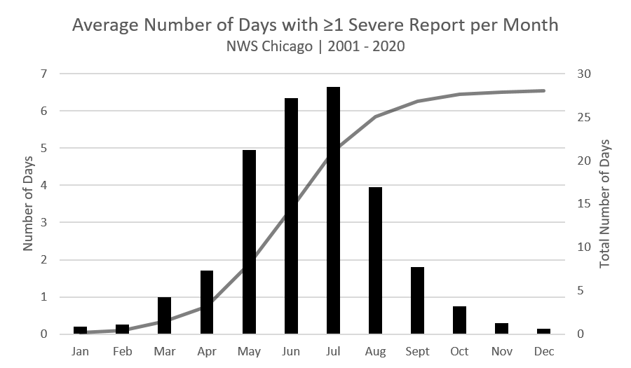
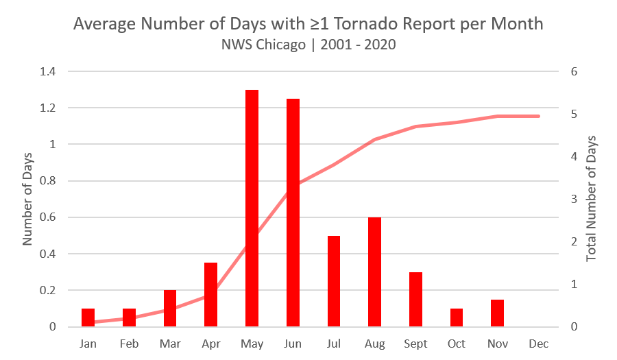
Regardless of the rarity of December severe weather, we are reminded that it can and does happen anytime of year. The two plots below show typical severe weather climatology in our area:
 |
 |
| Severe Weather Climatology by Month | Tornado Weather Climatology by Month |
More severe weather climatological information can be found here.
Maximum Wind Gusts
 |
 |
| Peak wind gusts on the morning of December 11. | Temperatures fell nearly 15°F in just one hour behind the cold front passage for many locations. |
Public Information Statement
National Weather Service Chicago IL
630 PM CST Sat Dec 11 2021

...Peak Wind Gusts for the Morning of 12/11/21...

The following list provides observed peak non-thunderstorm wind
gusts following the passage of a cold front during the morning
of 12/11/21.

Location                     Speed     Time/Date
Michigan City Light (Marine) 66 MPH    0830 AM 12/11
Chicago - Midway             64 MPH    0448 AM 12/11
Valparaiso Airport           62 MPH    0809 AM 12/11
West Chicago - DuPage Arpt.  60 MPH    0516 AM 12/11
Chicago - OHare              59 MPH    0520 AM 12/11
Harrison-Dever Crib (Marine) 59 MPH    0610 AM 12/11
Gary Airport                 58 MPH    0845 AM 12/11
Chicago - 63rd St. Beach     57 MPH    0400 AM 12/11
Sugar Grove - Aurora Arpt.   56 MPH    1025 AM 12/11
Crown Point                  55 MPH    0719 AM 12/11
Chicago - Montrose Beach     55 MPH    0602 AM 12/11
Rockford Airport             54 MPH    0446 AM 12/11
Waukegan Airport             54 MPH    0450 AM 12/11
Pontiac Airport              53 MPH    0335 AM 12/11
Wheeling-Chicago Exec. Arpt. 53 MPH    0538 AM 12/11
Peru Airport                 53 MPH    0515 AM 12/11
Rochelle Airport             52 MPH    0335 AM 12/11
Rensselaer Airport           51 MPH    0635 AM 12/11
Kankakee Airport             51 MPH    0656 AM 12/11
McHenry (McHenry DOT)        49 MPH    0600 AM 12/11
DeKalb Airport               48 MPH    0455 AM 12/11
Lansing Airport              48 MPH    0715 AM 12/11
Romeoville - Lewis Airport   47 MPH    0455 AM 12/11
Midewin Prairie              47 MPH    0705 AM 12/11
Morris Airport               46 MPH    0535 AM 12/11

Observations are collected from a variety of sources with varying
equipment and exposures. We thank all volunteer weather observers
for their dedication. Not all data listed are considered official.

$$

Kluber
Rainfall
 |
| 24-hour rainfall ending December 11th at 6 A.M. |
Rockford, IL has been dry much of 2021, but the 1.20" inches observed on Friday, December 10 made it the second wettest calendar day of this year, after only 2.52" on August 9th. It's rare to have such a wet December day. In fact, this was also the wettest December day for Rockford in six Decembers (2015).
Public Information Statement
National Weather Service Chicago IL
600 PM CST Sat Dec 11 2021

...Friday December 10th Rainfall Roundup...

   The following are rain amounts for the previous 24-hours
   as measured in the morning by NWS Cooperative Observers
   and CoCoRaHS observers.
   Observations are usually taken between 6 AND 8 AM.

   24-hour rainfall amounts
       for Saturday(12/11/21)...


Illinois                                       Rain
  Location (County):                           fall (inches)

  Lake Villa 2WSW (Lake).......................2.67
  Lake Villa 1SSW (Lake).......................2.31
  Lakemoor 2NW (McHenry).......................2.31
  Crystal Lake (McHenry).......................2.17
  Bull Valley 2WNW (McHenry)...................2.02
  Woodstock 4SW (McHenry)......................2.00
  Crystal Lake 1WSW (McHenry)..................1.78
  Genoa (De Kalb)..............................1.68
  Waukegan (Lake)..............................1.50
  Sterling 4NE (Lee)...........................1.47
  Woodstock 5nw (McHenry)......................1.39
  Park Forest 1NNE (Cook)......................1.32
  Ottawa 2N (La Salle).........................1.32
  New Lenox 3ENE (Will)........................1.32
  Waukegan 2N (Lake)...........................1.31
  Ashton (Lee).................................1.25
  Ottawa 1NW (La Salle)........................1.25
  Ottawa (La Salle)............................1.25
  Flossmoor 1ESE (Cook)........................1.23
  St Anne (Kankakee)...........................1.23
  Rockford (Winnebago).........................1.22
  Plainfield 2SSE (Will).......................1.19
  Crete 3E (Will)..............................1.17
  Paw Paw (Lee)................................1.15
  Park Forest (Cook)...........................1.15
  Morris 6ESE (Grundy).........................1.14
  Channahon 2SSE (Will)........................1.14
  Coal City 3N (Grundy)........................1.13
  Rockford 2ENE (Winnebago)....................1.13
  Mundelein (Lake).............................1.13
  Hebron (McHenry).............................1.12
  Mundelein 2WNW (Lake)........................1.09
  Coal City 4NNW (Grundy)......................1.08
  Carbon Hill 3.1N (Grundy)....................1.08
  Elgin (Kane).................................1.07
  Gilberts (Kane)..............................1.07
  Peru 1ENE (La Salle).........................1.07
  Lansing (Cook)...............................1.07
  Midlothian (Cook)............................1.06
  Mundelein (Lake).............................1.06
  La Salle (La Salle)..........................1.06
  Minooka (Grundy).............................1.05
  Romeoville (Will)............................1.05
  Buffalo Grove 2N (Lake)......................1.04
  Emington 2SSE (Livingston)...................1.04
  Joliet 3WNW (Will)...........................1.04
  Joliet 2n (Will).............................1.04
  Hoffman Estates 5W (Cook)....................1.03
  Peotone (Will)...............................1.03
  Bourbonnais (Kankakee).......................1.01
  Lake Bluff 1W (Lake).........................1.01
  Lake Zurich (Lake)...........................1.01
  Chatsworth (Livingston)......................1.00
  Ravenswood Manor (Cook)......................1.00
  Lake Zurich 1N (Lake)........................1.00
  Countryside 1ENE (Cook)......................0.99
  Plainfield 5SW (Kendall).....................0.99
  Manhattan 1ESE (Will)........................0.98
  Schaumburg 2E (Cook).........................0.97
  Chicago 6ESE (Cook)..........................0.97
  St. Charles 6NW (Kane).......................0.97
  Winnetka 1ESE (Cook).........................0.96
  Lincolnwood 3E (Cook)........................0.96
  Burr Ridge 2SW (Du Page).....................0.96
  Elgin 2W (Kane)..............................0.96
  Mokena 1W (Will).............................0.96
  Barrington (Lake)............................0.95
  Elgin (Kane).................................0.95
  Elgin 1S (Kane)..............................0.95
  Riverwoods (Lake)............................0.95
  Capron (Boone)...............................0.94
  Hoffman Estates 2SE (Cook)...................0.94
  Palatine 1NNE (Cook).........................0.94
  Naperville 2SE (Du Page).....................0.94
  Ashkum 5.6E (Iroquois).......................0.94
  St. Charles (Kane)...........................0.94
  Elgin 8WSW (Kane)............................0.94
  Manhattan 5ENE (Will)........................0.94
  Bannockburn (Lake)...........................0.93
  La Grange Park 1SSW (Cook)...................0.92
  Oswego 5SSE (Kendall)........................0.92
  New Lenox 2SE (Will).........................0.92
  Lisle 1SE (Du Page)..........................0.91
  New Lenox 3E (Will)..........................0.91
  Palos Park 4WNW (Cook).......................0.90
  Cortland (De Kalb)...........................0.90
  Darien (Du Page).............................0.90
  Highwood 1S (Lake)...........................0.90
  Manhattan (Will).............................0.90
  Streator (Livingston)........................0.90
  Bridgeview 1NNW (Cook).......................0.89
  Gibson 6NE (Ford)............................0.89
  Morris 5NNW (Grundy).........................0.89
  Wheeling (Cook)..............................0.89
  Geneva 4WSW (Kane)...........................0.88
  Elk Grove Village 2WSW (Cook)................0.87
  Westmont (Du Page)...........................0.87
  Palos Park 1SW (Cook)........................0.86
  Oak Park 1NNE (Cook).........................0.86
  Lincolnwood 2E (Cook)........................0.86
  Bolingbrook 3NE (Du Page)....................0.86
  Aurora 4SE (Du Page).........................0.86
  Elmhurst (Du Page)...........................0.86
  Midway Coop (Cook)...........................0.86
  Aurora (Kane)................................0.85
  Oak Lawn 2SE (Cook)..........................0.85
  Oak Park 1SW (Cook)..........................0.85
  Earlville 5NNE (De Kalb).....................0.85
  Lombard 1NNW (Du Page).......................0.85
  Geneva 1SSW (Kane)...........................0.85
  Park Ridge 1WNW (Cook).......................0.84
  Harwood Heights (Cook).......................0.84
  Aurora 4SE (Du Page).........................0.84
  Elmhurst 1ESE (Du Page)......................0.84
  Coal City (Grundy)...........................0.84
  Montgomery 1SSE (Kendall)....................0.84
  Elburn (Kane)................................0.84
  Homer Glen 1ENE (Will).......................0.84
  Naperville 4SSW (Will).......................0.84
  Ohare Airport (Cook).........................0.84
  Earlville 3S (La Salle)......................0.83
  Chicago Ridge (Cook).........................0.83
  Elmhurst 2SE (Du Page).......................0.83
  Morris 2SSE (Grundy).........................0.83
  Pontiac (Livingston).........................0.83
  Wheaton 2NNE (Du Page).......................0.82
  Algonquin 1N (McHenry).......................0.82
  Brandon Road Lock & Dam (Will)...............0.82
  West Chicago (Du Page).......................0.81
  North Aurora 2NE (Kane)......................0.81
  Wilmington 3SE (Will)........................0.81
  Morris (Grundy)..............................0.80
  Batavia 2WNW (Kane)..........................0.80
  Lockport 1SE (Will)..........................0.80
  Midway (Cook)................................0.80
  Aurora (Kane)................................0.79
  Romeoville (Will)............................0.79
  Beecher 3ENE (Will)..........................0.78
  Peru (La Salle)..............................0.78
  DeKalb (De Kalb).............................0.76
  Watseka 6.9WNW (Iroquois)....................0.76
  Herscher 3E (Kankakee).......................0.76
  Joliet (Will)................................0.76
  De Kalb 1SW (De Kalb)........................0.75
  Rochelle (Ogle)..............................0.75
  Sugar Grove 1NE (Kane).......................0.72
  Batavia (Kane)...............................0.71
  Dwight (Livingston)..........................0.71
  Mendota (La Salle)...........................0.69
  Cissna Park 1S (Iroquois)....................0.68
  Palatine 1E (Cook)...........................0.67
  Streator 1WSW (La Salle).....................0.67
  Gibson 3WNW (Ford)...........................0.49
  Sugar Grove 1ENE (Kane)......................0.47
  Marseilles Lock and Dam (La Salle)...........0.46

Indiana                                        Rain
  Location (County):                           fall (inches)

  De Motte 6S (Jasper).........................1.70
  Wheatfield 4WSW (Jasper).....................1.59
  Valparaiso 1NE (Porter)......................1.51
  Valparaiso 1NNW (Porter).....................1.37
  Valparaiso 2WSW (Porter).....................1.36
  Valparaiso 6SSW (Porter).....................1.36
  Valparaiso 4SW (Porter)......................1.31
  Valparaiso 2N (Porter).......................1.27
  Lakes Of The Four Seasons (Porter)...........1.26
  Valparaiso 2WNW (Porter).....................1.25
  Dyer 1WNW (Lake).............................1.23
  Hebron 4NE (Porter)..........................1.19
  Hobart 2E (Lake).............................1.11
  Valparaiso (Porter)..........................1.11
  Morocco (Newton).............................1.05
  Schererville 1E (Lake).......................0.95
  Rensselaer (Jasper)..........................0.92
  Schererville 1E (Lake).......................0.91
  Gary 5ENE (Lake).............................0.87
  St. John (Lake)..............................0.79
  De Motte 4SW (Jasper)........................0.78
  Rensselaer 2SSW (Jasper).....................0.77
  De Motte 1SSW (Jasper).......................0.76
  Crown Point (Lake)...........................0.75
  De Motte 1NNW (Jasper).......................0.75
  Crown Point 1N (Lake)........................0.75
  Rensselaer 10NNE (Jasper)....................0.73
  Mount Ayr 2NNE (Newton)......................0.73
  Chesterton 4E (Porter).......................0.70
  Kentland 2SSE (Newton).......................0.69
  Wheatfield 3S (Jasper).......................0.68
  Chesterton 1ENE (Porter).....................0.68
  Rensselaer 6SE (Jasper)......................0.66
  Portage 3E (Porter)..........................0.65
  Porter 1S (Porter)...........................0.62
  Rensselaer 4N (Jasper).......................0.61
  Remington (Jasper)...........................0.51
Additional Info
 |
Media use of NWS Web News Stories is encouraged! Please acknowledge the NWS as the source of any news information accessed from this site. Additional recaps can be found on the NWS Chicago Past Events Page |
 |