Overview
|
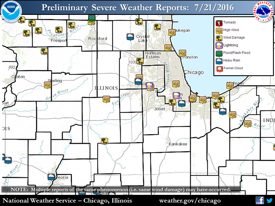
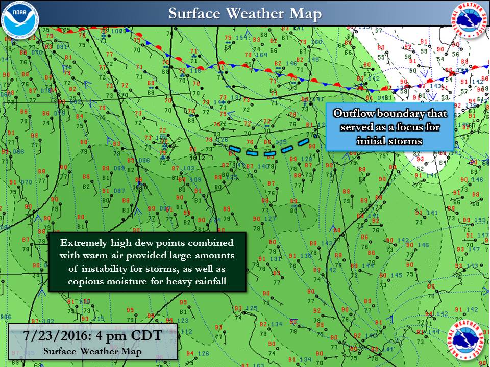
July 21st through July 24th brought a very humid and hot pattern across the Midwest, including northern Illinois and northwest Indiana. The high moisture and heat brought dangerous heat index readings as well as high to extreme instability for thunderstorms. Many of these storms were heavy rain producers, with some also bringing damaging winds. The upper level pattern was one that meteorologists refer to as "the ring of fire", in that there was a semi-circular pattern of storm complexes around the large dome of heat.
|
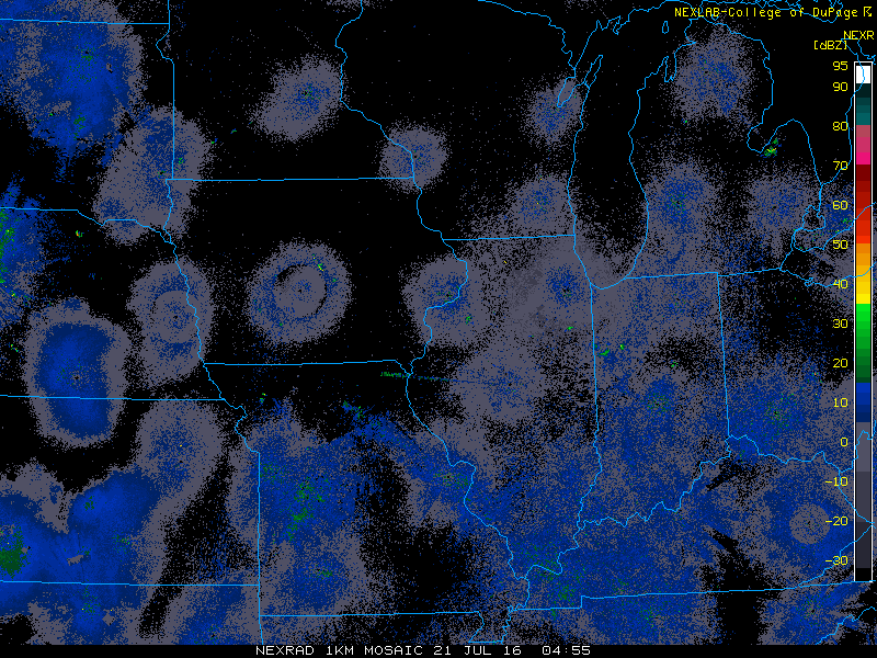 Regional radar loop from 12 a.m. July 21st through 12 pm July 25th. Created by using radar graphics from College of DuPage Meteorology Regional radar loop from 12 a.m. July 21st through 12 pm July 25th. Created by using radar graphics from College of DuPage Meteorology |
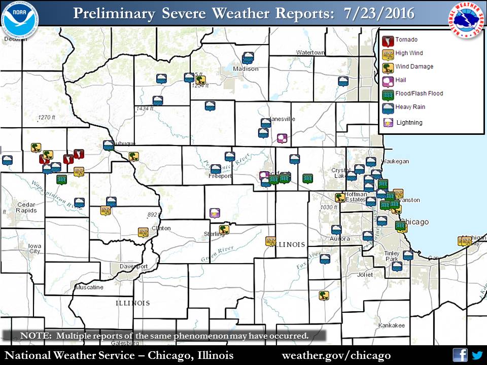
Storm Reports:
 |
| Storm Reports from July 21-24 |
PRELIMINARY LOCAL STORM REPORT...SUMMARY
NATIONAL WEATHER SERVICE CHICAGO/ROMEOVILLE IL
833 AM CDT FRI JUL 22 2016

..TIME...   ...EVENT...      ...CITY LOCATION...     ...LAT.LON...
..DATE...   ....MAG....      ..COUNTY LOCATION..ST.. ...SOURCE....
            ..REMARKS..

1210 PM     TSTM WND GST     5 SSE BEACH PARK        42.36N 87.81W
07/21/2016  M42.00 MPH       LMZ740             IL   C-MAN STATION

            MEASURED AT WAUKEGAN HARBOR.

1230 PM     TSTM WND GST     6 E GLENCOE             42.13N 87.65W
07/21/2016  M40.00 MPH       LMZ740             IL   BUOY

            MEASURED AT WILMETTE BUOY.

1252 PM     HEAVY RAIN       HOMEWOOD                41.56N 87.66W
07/21/2016  M0.89 INCH       COOK               IL   COCORAHS

            RAIN FELL IN 18 MINUTES.

0100 PM     HEAVY RAIN       1 SSW HAMMOND           41.61N 87.50W
07/21/2016  M0.97 INCH       LAKE               IN   COCORAHS

            RAIN FELL IN 20 MINUTES

0104 PM     TSTM WND DMG     HAMMOND                 41.62N 87.49W
07/21/2016                   LAKE               IN   PUBLIC

            TWO LARGE TREES DOWNED IN RESIDENTIAL NEIGHBORHOOD NEAR
            165TH STREET AND CLINE AVENUE. TIME ESTIMATED PER RADAR.

0108 PM     TSTM WND GST     HAMMOND                 41.62N 87.49W
07/21/2016  E50.00 MPH       LAKE               IN   TRAINED SPOTTER

0114 PM     TSTM WND GST     GARY                    41.60N 87.34W
07/21/2016  M62.00 MPH       LAKE               IN   AWOS

            MEASURED AT GARY AIRPORT.

0138 PM     TSTM WND DMG     CHESTERTON              41.60N 87.06W
07/21/2016                   PORTER             IN   EMERGENCY MNGR

            NUMEROUS BRANCHES DOWN OFF TREES.

0138 PM     TSTM WND DMG     SOUTH HAVEN             41.54N 87.13W
07/21/2016                   PORTER             IN   EMERGENCY MNGR

            SEVERAL MEDIUM SIZE TREE BRANCHES AND POWER LINES DOWN.
            TIME ESTIMATED OFF RADAR.

0140 PM     TSTM WND GST     3 NNW BURNS HARBOR      41.65N 87.15W
07/21/2016  M39.00 MPH       PORTER             IN   BUOY

0215 PM     HEAVY RAIN       1 SE VALPARAISO         41.47N 87.04W
07/21/2016  M1.32 INCH       PORTER             IN   COCORAHS

            RAIN FELL IN 20 MINUTES.

0704 PM     TSTM WND DMG     RICHMOND                42.48N 88.31W
07/21/2016                   MCHENRY            IL   LAW ENFORCEMENT

            TREES DOWN RT 173 AND KEYSTONE ROAD.

0724 PM     TSTM WND DMG     WOODSTOCK               42.31N 88.44W
07/21/2016                   MCHENRY            IL   LAW ENFORCEMENT

            TREES DOWN NELSON AND ROSE FARM ROADS.

0734 PM     TSTM WND DMG     RICHMOND                42.48N 88.31W
07/21/2016                   MCHENRY            IL   LAW ENFORCEMENT

            TREES DOWN PIONEER AND HART ROADS.

0743 PM     TSTM WND GST     SOUTH BELOIT            42.48N 89.03W
07/21/2016  M60.00 MPH       WINNEBAGO          IL   AMATEUR RADIO

            HAYES AND LISTEN AVENUES.

0745 PM     TSTM WND DMG     LINDENHURST             42.42N 88.03W
07/21/2016                   LAKE               IL   PUBLIC

            SMALL TO MEDIUM SIZE TREE LIMBS BLOWN DOWN. TIME
            ESTIMATED.

0758 PM     TSTM WND DMG     ELGIN                   42.04N 88.29W
07/21/2016                   KANE               IL   PUBLIC

            POWER LINES BLOWN DOWN. TIME ESTIMATED.

0758 PM     TSTM WND DMG     ELGIN                   42.04N 88.29W
07/21/2016                   KANE               IL   TRAINED SPOTTER

            TREE LIMBS 4 TO 6 INCH DIAMETER BLOWN DOWN. ESTIMATED
            WINDS 50 MPH.

0810 PM     TSTM WND DMG     DURAND                  42.44N 89.33W
07/21/2016                   WINNEBAGO          IL   PUBLIC

            TWO TREES DOWN ACROSS ROAD WITH ONE UTILITY POLE PULLED
            DOWN BY TREES. TIME ESTIMATED. VIA FACEBOOK.

0850 PM     TSTM WND GST     LELAND                  41.61N 88.80W
07/21/2016  E50.00 MPH       LA SALLE           IL   TRAINED SPOTTER

            WIND GUSTS ESTIAMTED 45-50 MPH

0900 PM     TSTM WND GST     2 SE NAPERVILLE         41.74N 88.13W
07/21/2016  M50.00 MPH       DUPAGE             IL   TRAINED SPOTTER

0902 PM     TSTM WND GST     BATAVIA                 42.19N 87.87W
07/21/2016  M51.00 MPH       LAKE               IL   TRAINED SPOTTER

0902 PM     TSTM WND GST     BATAVIA                 41.85N 88.30W
07/21/2016  M51.00 MPH       KANE               IL   TRAINED SPOTTER

0907 PM     TSTM WND GST     MIDWAY AIRPORT          41.78N 87.75W
07/21/2016  M47.00 MPH       COOK               IL   ASOS

0908 PM     LIGHTNING        N NAPERVILLE            41.76N 88.15W
07/21/2016                   DUPAGE             IL   EMERGENCY MNGR

            STRUCK A GAS LINE STARTING A FIRE.

0915 PM     HEAVY RAIN       WOODSTOCK               42.31N 88.44W
07/21/2016  M1.07 INCH       MCHENRY            IL   CO-OP OBSERVER

            STORM TOTAL 1.07 INCHES.

0951 PM     TSTM WND GST     5 SSE BEACH PARK        42.36N 87.81W
07/21/2016  M52.00 MPH       LMZ740             IL   C-MAN STATION

            MEASURED AT WAUKEGAN HARBOR.

1002 PM     LIGHTNING        CRESTWOOD               41.65N 87.74W
07/21/2016                   COOK               IL   PUBLIC

            TRANSFORMER STRUCK BY LIGHTNING.

1002 PM     TSTM WND DMG     TINLEY PARK             41.57N 87.80W
07/21/2016                   COOK               IL   PUBLIC

            POWER LINES BLOWN DOWN.

1018 PM     TSTM WND DMG     STREATOR                41.13N 88.83W
07/21/2016                   LA SALLE           IL   911 CALL CENTER

            MULTIPLE POWER POLES...POWER LINES...AND TREES DOWN.
            SEVERAL TREES ON HOUSES.

1020 PM     TSTM WND GST     3 NNW BURNS HARBOR      41.65N 87.15W
07/21/2016  M39.00 MPH       PORTER             IN   C-MAN STATION

1130 PM     HEAVY RAIN       1 NE NORTH AURORA       41.81N 88.32W
07/21/2016  M1.78 INCH       KANE               IL   COCORAHS

            RAINFALL TOTAL THUS FAR.
PRELIMINARY LOCAL STORM REPORT...SUMMARY
NATIONAL WEATHER SERVICE CHICAGO/ROMEOVILLE IL
1047 AM CDT SUN JUL 24 2016
..TIME... ...EVENT... ...CITY LOCATION... ...LAT.LON...
..DATE... ....MAG.... ..COUNTY LOCATION..ST.. ...SOURCE....
..REMARKS..
0458 PM TSTM WND DMG BELVIDERE 42.25N 88.85W
07/23/2016 BOONE IL LAW ENFORCEMENT
NUMEROUS LARGE BRANCHED DOWNED IN THE CITY. RADAR
ESTIMATED TIME.
0515 PM TSTM WND DMG MARENGO 42.25N 88.60W
07/23/2016 MCHENRY IL LAW ENFORCEMENT
LARGE TREE BLOWN DOWN. TIME ESTIMATED BY RADAR.
0520 PM HEAVY RAIN N CAPRON 42.40N 88.74W
07/23/2016 M2.15 INCH BOONE IL COCORAHS
2.15 INCHES IN LAST 2.5 HOURS.
0532 PM HAIL CHERRY VALLEY 42.24N 88.96W
07/23/2016 E1.00 INCH WINNEBAGO IL TRAINED SPOTTER
ALSO 55 TO 60 MPH WINDS AND VERY HEAVY RAINFALL WITH
VISIBILITY AROUND 200 FEET.
0545 PM HEAVY RAIN GURNEE 42.38N 87.94W
07/23/2016 M2.30 INCH LAKE IL BROADCAST MEDIA
2.30 INCHES IN 45 MINUTES.
0555 PM MARINE TSTM WIND 6 E GLENCOE 42.13N 87.65W
07/23/2016 M51.00 MPH LMZ740 IL BUOY
TIME ESTIMATED BY RADAR.
0600 PM HEAVY RAIN 4 SSE ROCKFORD 42.22N 89.04W
07/23/2016 M2.41 INCH WINNEBAGO IL COCORAHS
PAST 75 MINUTES
0605 PM HEAVY RAIN 3 NNW LAKE FOREST 42.28N 87.88W
07/23/2016 M1.52 INCH LAKE IL COCORAHS
PAST 48 MINUTES.
0608 PM HEAVY RAIN 1 NE BELVIDERE 42.26N 88.83W
07/23/2016 M2.97 INCH BOONE IL COCORAHS
2.97 INCHES OF RAIN OVER PAST 2.5 HOURS.
0610 PM HEAVY RAIN HIGHLAND PARK 42.18N 87.81W
07/23/2016 M1.75 INCH LAKE IL TRAINED SPOTTER
MEASURED 1 HOUR RAINFALL.
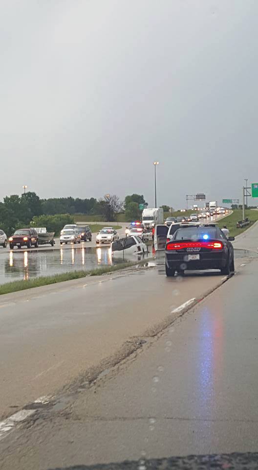
0611 PM FLASH FLOOD CHERRY VALLEY 42.24N 88.96W
07/23/2016 WINNEBAGO IL TRAINED SPOTTER
ROAD FLOODED WITH MULTIPLE VEHICLES STRANDED/FLOODED.
I-39 AND US ROUTE 20.
0615 PM TSTM WND DMG EVANSTON 42.05N 87.69W
07/23/2016 COOK IL TRAINED SPOTTER
SEVERAL 6 INCH DIAMETER BRANCHES DOWN.
0615 PM LIGHTNING WILMETTE 42.08N 87.73W
07/23/2016 COOK IL PUBLIC
LIGHTNING STRUCK AND DOWNED A 30 FT LONG BRANCH WITH TOOK
DOWN POWERLINES WITH AN ESTIMATED 200 HOMES WITHOUT
POWER.
0628 PM TSTM WND GST SKOKIE 42.04N 87.74W
07/23/2016 E60.00 MPH COOK IL AMATEUR RADIO
WIND ESTIMATED AT 55-60 MPH. DEMPSTER STREET WEST OF
SKOKIE BLVD.
0632 PM MARINE TSTM WIND 2 SSE CHICAGO 41.86N 87.61W
07/23/2016 M56.00 MPH COOK IL C-MAN STATION
0642 PM TSTM WND DMG ROGERS PARK 42.01N 87.67W
07/23/2016 COOK IL COCORAHS
A FEW LARGE LIMBS DOWNED. RADAR ESTIMATED TIME.
0700 PM FLASH FLOOD EVANSTON 42.05N 87.69W
07/23/2016 COOK IL PUBLIC
WATER UP TO THE BOTTOM OF CARS ALONG SHERIDAN ROAD. TIME
ESTIMATED PER RADAR. REPORT RECEIVED AFTER THE EVENT.
0700 PM FLASH FLOOD HIGHWOOD 42.21N 87.81W
07/23/2016 LAKE IL AMATEUR RADIO
CAR STRANDED IN 2.5 FEET OF WATER AT GREEN BAY ROAD AND
BURCHELL ROADS.
0708 PM TSTM WND DMG EAST DUNDEE 42.10N 88.26W
07/23/2016 KANE IL LAW ENFORCEMENT
BRANCHES DOWN AT ROUTE 25 AND SUNSET PARK. CORRECTED FOR
RADAR ESTIMATED TIME.
0715 PM FLASH FLOOD S BELVIDERE 42.25N 88.85W
07/23/2016 BOONE IL LAW ENFORCEMENT
MULTIPLE ROADS FLOODED AND CLOSED ON THE SOUTH SIDE OF
TOWN. TIME ESTIMATED IN REPORT.
0740 PM TSTM WND GST 5 N TOWN OF PINES 41.76N 86.97W
07/23/2016 M40.00 MPH LMZ745 IN BUOY
0740 PM FLOOD CHICAGO 41.88N 87.63W
07/23/2016 COOK IL PUBLIC
STREET FLOODING AT ASHLAND AND WEBSTER. FROM SOCIAL
MEDIA.
0745 PM FLOOD WINNETKA 42.11N 87.74W
07/23/2016 COOK IL AMATEUR RADIO
VIADUCT FLOODED AT WILSON STREET AND WINNETKA ROAD.
0745 PM FLOOD CHICAGO 41.88N 87.63W
07/23/2016 COOK IL AMATEUR RADIO
VIADUCT FLOODED AT SACRAMENTO AND CARROL. NEAR WEST SIDE.
0758 PM TSTM WND DMG POLO 41.98N 89.58W
07/23/2016 OGLE IL CO-OP OBSERVER
OLD SHED KNOCKED DOWN, PORTION OF AN OLD BARN DAMAGED,
AND BRANCHES DOWNED. RADAR ESTIMATED TIME.
0800 PM LIGHTNING POLO 41.98N 89.58W
07/23/2016 OGLE IL LAW ENFORCEMENT
LIGHTNING STRUCK A HOUSE CAUSING A FIRE.
0800 PM HEAVY RAIN WAUCONDA 42.27N 88.14W
07/23/2016 E2.00 INCH LAKE IL AMATEUR RADIO
RAINFALL THROUGH 8 PM CDT.
0800 PM HEAVY RAIN VERNON HILLS 42.24N 87.96W
07/23/2016 M2.90 INCH LAKE IL PUBLIC
RAINFALL FROM EARLIER STORMS. VIA SOCIAL MEDIA.
0808 PM TSTM WND DMG DIXON 41.85N 89.48W
07/23/2016 LEE IL LAW ENFORCEMENT
MULTIPLE POWER LINES DOWN IN THE TOWN OF DIXON. TIME
ESTIMATED FROM RADAR.
0913 PM TSTM WND GST 6 W SHABBONA 41.76N 88.99W
07/23/2016 E55.00 MPH LEE IL TRAINED SPOTTER
ESTIMATED 50-55 MPH GUST. HEAVY RAIN...CONTINUOUS
LIGHTNING.
1017 PM HEAVY RAIN BATAVIA 41.85N 88.30W
07/23/2016 M1.40 INCH KANE IL CO-OP OBSERVER
RAIN TOTAL THUS FAR AS IT IS STILL RAINING.
1027 PM HEAVY RAIN ROUND LAKE PARK 42.32N 88.06W
07/23/2016 M2.24 INCH LAKE IL PUBLIC
FROM SOCIAL MEDIA.
1030 PM HEAVY RAIN 1 N BUFFALO GROVE 42.18N 87.96W
07/23/2016 M2.78 INCH LAKE IL COCORAHS
RAINFALL OF 2.78 INCHES OVER THE PAST FOUR HOURS.
1038 PM HEAVY RAIN 2 SE YORKVILLE 41.62N 88.42W
07/23/2016 M2.20 INCH KENDALL IL CO-OP OBSERVER
2.20 INCHES IN 45 MINUTES. STILL RAINING.
1039 PM TSTM WND DMG 3 S MORRIS 41.33N 88.43W
07/23/2016 GRUNDY IL LAW ENFORCEMENT
COUPLE TREES DOWNED. NUMEROUS LARGE BRANCHES DOWNED.
OUTBUILDING DAMAGED. RADAR ESTIMATED TIME.
1049 PM FLOOD MORTON GROVE 42.04N 87.79W
07/23/2016 COOK IL EMERGENCY MNGR
STANDING WATER HAD CLOSED GOLF RD AND WAUKEGAN RD IN
MORTON GROVE, AND THE ROAD IS NOW OPEN.
1110 PM HEAVY RAIN 1 NNW BURNHAM 41.65N 87.55W
07/23/2016 M1.05 INCH COOK IL COCORAHS
1.05 INCHES IN LAST 40 MINUTES.
1110 PM HEAVY RAIN 1 NNW BURNHAM 41.65N 87.55W
07/23/2016 M1.40 INCH COOK IL COCORAHS
1.05 INCHES IN THE PAST 40 MINUTES.
1140 PM HEAVY RAIN NORTHBROOK 42.13N 87.83W
07/23/2016 M3.14 INCH COOK IL LAW ENFORCEMENT
STORM TOTAL 3.14 INCHES AT NORTHBROOK WATER PLANT.
PRELIMINARY LOCAL STORM REPORT...SUMMARY
NATIONAL WEATHER SERVICE CHICAGO/ROMEOVILLE IL
555 PM CDT MON JUL 25 2016

..TIME...   ...EVENT...      ...CITY LOCATION...     ...LAT.LON...
..DATE...   ....MAG....      ..COUNTY LOCATION..ST.. ...SOURCE....
            ..REMARKS..

0607 PM     TSTM WND GST     SKOKIE                  42.04N 87.74W
07/24/2016  E50.00 MPH       COOK               IL   AMATEUR RADIO

0629 PM     TSTM WND DMG     HUMBOLDT PARK           41.90N 87.70W
07/24/2016                   COOK               IL   PUBLIC

            NUMEROUS LARGE BRANCHES DOWN. ESTIMATED TIME PER RADAR.

0638 PM     HAIL             6 N CHICAGO             41.96N 87.65W
07/24/2016  E1.00 INCH       COOK               IL   TRAINED SPOTTER

            QUARTER SIZE HAIL NEAR BUENA PARK.

0640 PM     TSTM WND DMG     3 NNW CHICAGO           41.92N 87.65W
07/24/2016                   COOK               IL   EMERGENCY MNGR

            WIRES DOWNED ONTO L BROWN LINE. RADAR ESTIMATED TIME.

0640 PM     TSTM WND DMG     1 W CHICAGO             41.88N 87.66W
07/24/2016                   COOK               IL   EMERGENCY MNGR

            DELAYED REPORT. RACINE BLUE LINE STATION CANOPY COLLAPSED
            DUE TO WIND...WITH THE STRUCTURE FALLING ONTO THE THIRD
            RAIL APPARENTLY CAUSING THE SPARKING AND EXPLOSIONS SEEN
            ON VIDEO. CONFIRMED WITH CHICAGO OEMC.

0644 PM     TSTM WND DMG     CHICAGO                 41.88N 87.63W
07/24/2016                   COOK               IL   EMERGENCY MNGR

            MULTIPLE STREET LIGHTS DAMAGED. RADAR ESTIMATED TIME.

0644 PM     TSTM WND GST     1 SSE CHICAGO           41.87N 87.62W
07/24/2016  M73.00 MPH       COOK               IL   BROADCAST MEDIA

            AT MICHIGAN AND ROOSEVELT IN THE SOUTH LOOP

0644 PM     MARINE TSTM WIND 4 NE CHICAGO            41.92N 87.57W
07/24/2016  M58.00 MPH       LMZ741             IL   C-MAN STATION

            GUST TO 58 MPH AT HARRISON DEVER CRIB.

0645 PM     TSTM WND DMG     2 SSE CHICAGO           41.85N 87.61W
07/24/2016                   COOK               IL   PUBLIC

            TREE BLOWN DOWN AND SEVERAL TREE LIMBS BLOWN DOWN. FROM
            TWITTER.

0651 PM     TSTM WND GST     CHICAGO                 41.88N 87.63W
07/24/2016  E45.00 MPH       COOK               IL   BROADCAST MEDIA

            ESTIMATED GUSTS TO 45 MPH IN THE LOOP.

0707 PM     LIGHTNING        3 SW MIDWAY AIRPORT     41.75N 87.79W
07/24/2016                   COOK               IL   CO-OP OBSERVER

            DAMAGED NWS COOPERATIVE OBSERVER TEMPERATURE EQUIPMENT

0715 PM     FLASH FLOOD      5 WNW CHICAGO           41.91N 87.71W
07/24/2016                   COOK               IL   EMERGENCY MNGR

            FLOODED VIADUCT ALONG WITH MULTIPLE REPORTS OF WATER ON
            ROADS ON THE NORTH SIDE OF THE CITY OF CHICAGO.

0730 PM     MARINE TSTM WIND 2 NNW BURNS HARBOR      41.65N 87.15W
07/24/2016  M45.00 MPH       PORTER             IN   C-MAN STATION

0731 PM     TSTM WND DMG     BLUE ISLAND             41.66N 87.68W
07/24/2016                   COOK               IL   EMERGENCY MNGR

            NUMEROUS TREES DOWN AND SNAPPED, POWER LINES DOWN, AND
            NUMEROUS POWER POLES DOWN. A COUPLE OF POWER POLES WERE
            SNAPPED. RADAR INDICATIONS THIS WAS A MICROBURST. RADAR
            ESTIMATED TIME.

0740 PM     MARINE TSTM WIND 3 NNE TOWN OF PINES     41.73N 86.93W
07/24/2016  M48.00 MPH       LMZ745             IN   C-MAN STATION

            GUST TO 48 MPH AT MICHIGAN CITY GLERL SITE.

0800 PM     HEAVY RAIN       3 NNW ALSIP             41.71N 87.75W
07/24/2016  M1.08 INCH       COOK               IL   COCORAHS

            PAST HOUR. STORMS HAVE HAD DANGEROUS CLOUD TO GROUND
            LIGHTNING.

0842 PM     TSTM WND DMG     3 ENE MOMENCE           41.18N 87.61W
07/24/2016                   KANKAKEE           IL   911 CALL CENTER

            UPDATED FOR LOCATION. SIX UTILITY BENT ON 4000N BETWEEN
            6000E AND 8000E AND A HALF DOZEN TREES DOWNED. INITIALLY
            REPORTED BY TRAINED STORM SPOTTER. TIME ESTIMATED. RADAR
            INDICATIONS ARE THIS WAS A MICROBURST.


&&

$$

MTF
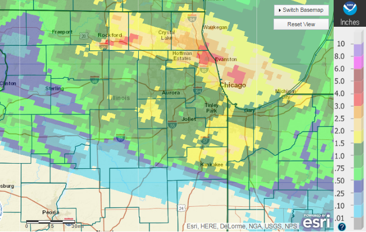
Rainfall:
 |
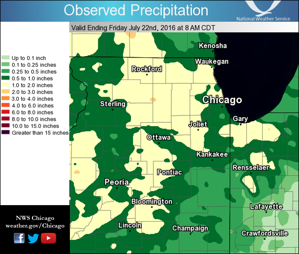
| Rainfall from July 21-24 |
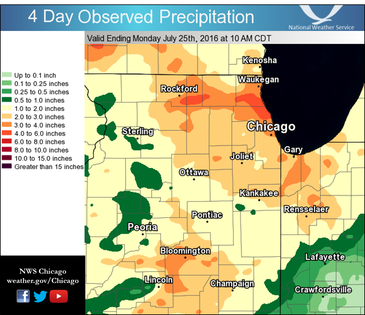
The summer period has been on the drier side, but most locations
picked up substantial rainfall during this four day period. The
following table is a listing of total precipitation over the same
time period from local ASOS stations. A graphic depicting total
precipitation for the area is available on our webpage.

Location                     Total Precipitation
-----------------------------------------------------------------
Wheeling - Chi Exec Airport          3.41"
Chicago O`Hare                       3.09"
Rockford Airport                     2.99"
Romeoville - Lewis Aiprort           2.91"
Sugar Grove - Aurora Airport         2.71"
Dupage Airport                       2.52"
Valparaiso Airport                   2.47"
Waukegan Airport                     2.34"
Chicago Midway                       2.24"

Observations are collected from a variety of sources with varying
equipment and exposures. Not all data listed are considered official.
KMD/JEE/MTF
Public Information Statement
National Weather Service Chicago/Romeoville IL
1149 AM CDT Mon Jul 25 2016


...4-Day Rainfall Round-up...

The following are rainfall amounts for the previous 4 days
as measured in the morning by NWS Cooperative observers
and CoCoRaHS observers. Observations are usually
taken between 6 AM and 8 AM.

  4-day rain totals for Monday (07/25/16)
     as of 11:49 AM CDT

ILLINOIS                                 4-Day rainfall
  Location (County):                         Amt(inches) reports

  Belvidere (Boone)............................6.45     (2)
  Highwood 1S (Lake)...........................5.42     (3)
  Riverwoods (Lake)............................4.90     (3)
  Glencoe (Cook)...............................4.81     (4)
  Winnetka 1ESE (Cook).........................4.67     (3)
  Botanic Gardens (Cook).......................4.64     (3)
  Lincolnwood 3E (Cook)........................4.38     (3)
  Harwood Heights 2NNE (Cook)..................4.36     (3)
  Yorkville 2SE (Kendall)......................4.08     (3)
  Lincolnwood 2E (Cook)........................3.95     (3)
  Capron (Boone)...............................3.95     (2)
  Buffalo Grove 2N (Lake)......................3.88     (3)
  North Aurora 2NE (Kane)......................3.86     (3)
  Park Ridge (Cook)............................3.84     (3)
  Park Ridge 1WNW (Cook).......................3.81     (3)
  Lansing (Cook)...............................3.75     (3)
  Mundelein (Lake).............................3.69     (3)
  Lake Forest 2NNE (Lake)......................3.68     (2)
  Mundelein 2WNW (Lake)........................3.68     (3)
  Chicago 5NE (Cook)...........................3.59     (3)
  Minooka (Grundy)..............................3.5     (3)
  Homewood (Cook)..............................3.48     (3)
  Park Forest (Cook)...........................3.46     (3)
  Downers Grove 0.4NNE (Du Page)...............3.46     (4)
  Chicago 6NNE (Cook)..........................3.46     (2)
  Morris 5NNW (Grundy).........................3.43     (3)
  Wheeling (Cook)..............................3.41     (3)
  Manteno 2SSE (Kankakee)......................3.41     (2)
  Belvidere 2NE (Boone)........................3.41     (1)
  Lansing (Cook)...............................3.39     (3)
  Joliet (Will)................................3.38     (2)
  Oswego 5SSE (Kendall)........................3.36     (2)
  Carbon Hill 3.1N (Grundy)....................3.34     (3)
  Coal City 4NNW (Grundy)......................3.34     (3)
  Woodstock 1SSW (McHenry).....................3.32     (2)
  Coal City 3N (Grundy).........................3.3     (4)
  Flossmoor (Cook).............................3.29     (3)
  Palatine 1E (Cook)...........................3.29     (3)
  Montgomery 1SSE (Kendall)....................3.28     (2)
  Mchenry (McHenry)............................3.25     (3)
  Gibson 3WNW (Ford)...........................3.22     (2)
  Schaumburg 2E (Cook).........................3.22     (2)
  Joliet 2n (Will)..............................3.2     (2)
  Braceville (Grundy)...........................3.2     (3)
  Batavia (Kane)................................3.2     (3)
  Woodstock 5nw (McHenry)......................3.19     (2)
  Morris 2SSE (Grundy).........................3.18     (3)
  Lake Zurich (Lake)...........................3.14     (3)
  Harvard 3SSE (McHenry).......................3.14     (2)
  Sheridan 3SSE (La Salle).....................3.14     (3)
  Sugar Grove 1ENE (Kane)......................3.12     (3)
  Byron 3N (Ogle)..............................3.11     (4)
  Batavia 2WNW (Kane)..........................3.11     (3)
  Aurora 4NE (Du Page)..........................3.1     (3)
  Lisle 1SE (Du Page)...........................3.1     (3)
  Ohare (Cook).................................3.09     (3)
  Rochelle (Ogle)..............................3.07     (2)
  Momence 6SSW (Kankakee)......................3.07     (3)
  Alsip (Cook).................................3.07     (3)
  Chicago 6ESE (Cook)..........................3.07     (3)
  Lockport 3ESE (Will).........................3.06     (3)
  Elk Grove Village 2WSW (Cook)................3.02     (3)
  Momence (Kankakee)...........................3.02     (3)
  Crete 3E (Will)..............................3.01     (4)
  Yorkville 2SSE (Kendall)......................3.0     (2)
  Steward (Lee)................................2.99     (2)
  Rockford (Winnebago).........................2.99     (2)
  Joliet 3WNW (Will)...........................2.99     (2)
  Sugar Grove 1NE (Kane).......................2.98     (3)
  Wilmington 6NW (Will)........................2.95     (3)
  Lake Villa 1SSW (Lake).......................2.94     (3)
  Barrington (Lake)............................2.94     (3)
  Algonquin 2W (McHenry).......................2.93     (2)
  Batavia 1WSW (Kane)..........................2.93     (2)
  Oak Park 1NNE (Cook).........................2.92     (3)
  Streamwood 1W (Cook).........................2.92     (3)
  Romeoville (Will)............................2.91     (3)
  Algonquin 1N (McHenry).......................2.91     (3)
  Paw Paw (Lee)................................2.89     (2)
  Beach Park 1W (Lake).........................2.87     (2)
  Aurora (Kane)................................2.87     (3)
  Monee (Will).................................2.86     (3)
  Oak Park 2S (Cook)...........................2.86     (3)
  Geneva 1SSW (Kane)...........................2.85     (4)
  Gurnee 2W (Lake).............................2.85     (2)
  Channahon 1NNE (Will)........................2.82     (3)
  Chicago Ridge (Cook).........................2.82     (3)
  Channahon 2SSE (Will)........................2.81     (2)
  Joliet Lock/dam (Will)........................2.8     (3)
  Plainfield 3SE (Will).........................2.8     (2)
  Westmont (Du Page)...........................2.79     (3)
  Oak Park 1SW (Cook)..........................2.79     (3)
  Somonauk 2NE (De Kalb).......................2.76     (2)
  Elmhurst (Du Page)...........................2.74     (3)
  Plano (Kendall)..............................2.73     (3)
  Bolingbrook 3NE (Du Page)....................2.72     (3)
  Plainfield 1SW (Will)........................2.72     (3)
  Burnham-hegewisch 2NNW (Cook)................2.72     (3)
  Elk Grove Village 1ESE (Cook)................2.71     (3)
  Aurora (Kane)................................2.71     (3)
  Bourbonnais (Kankakee)........................2.7     (3)
  Aurora 4SE (Du Page).........................2.69     (2)
  Naperville 1NW (Du Page).....................2.64     (3)
  Oak Lawn (Cook)..............................2.63     (3)
  Midway Coop (Cook)...........................2.62     (3)
  Naperville 4SSW (Will)........................2.6     (3)
  Ravenswood Manor (Cook).......................2.6     (1)
  Roscoe 2se (Winnebago).......................2.59     (2)
  Roscoe 2ESE (Winnebago)......................2.59     (2)
  Elmhurst 2SE (Du Page).......................2.58     (3)
  Elmhurst 1ESE (Du Page)......................2.57     (3)
  Joliet (Will)................................2.56     (2)
  Lakemoor 2SE (Lake)..........................2.56     (2)
  Morris (Grundy)..............................2.56     (2)
  Joliet 2WNW (Will)...........................2.55     (2)
  Bridgeview 1NNW (Cook).......................2.54     (3)
  Beecher 3SSE (Will)..........................2.53     (3)
  Ashton (Lee).................................2.53     (2)
  Villa Park 1NW (Du Page).....................2.52     (3)
  West Chicago (Du Page).......................2.52     (3)
  Elgin (Kane).................................2.51     (3)
  Morris (Grundy)..............................2.49     (3)
  Plainfield 5SW (Kendall).....................2.47     (2)
  Wilmington 3SE (Will)........................2.46     (3)
  Wonder Lake 1WNW (McHenry)...................2.42     (2)
  Naperville 2ESE (Du Page)....................2.42     (3)
  Aurora 3W (Kane).............................2.41     (2)
  Burr Ridge 2SW (Du Page)......................2.4     (3)
  Beecher 3ENE (Will)..........................2.39     (2)
  Lockport 1SE (Will)..........................2.39     (3)
  Willow Springs (Cook)........................2.37     (3)
  Lisle (Du Page)..............................2.37     (3)
  Montgomery 2SSE (Kendall)....................2.35     (3)
  Waukegan (Lake)..............................2.34     (3)
  St Anne (Kankakee)............................2.3     (3)
  Gilberts (Kane)...............................2.3     (2)
  Roselle 1W (Du Page)..........................2.3     (3)
  Roselle 1ESE (Du Page).......................2.29     (2)
  De Kalb (De Kalb)............................2.29     (3)
  Homer Glen 1ENE (Will).......................2.28     (4)
  Elburn (Kane)................................2.28     (2)
  Lisbon 4NE (Kendall).........................2.27     (2)
  Palos Park 1SW (Cook)........................2.27     (3)
  Winthrop Harbor 1SSW (Lake)..................2.26     (2)
  Elgin 2WNW (Kane)............................2.26     (3)
  Midway (Cook)................................2.24     (3)
  Elgin 8WSW (Kane)............................2.24     (3)
  St. Charles 6NW (Kane).......................2.24     (3)
  Winthrop Harbor (Lake).......................2.24     (2)
  Plainfield (Will)............................2.23     (3)
  Coal City (Grundy)...........................2.23     (3)
  De Kalb (De Kalb)............................2.21     (3)
  Manhattan 2SE (Will)..........................2.2     (3)
  Aurora 4SE (Du Page)..........................2.2     (2)
  Peotone (Will)................................2.2     (3)
  Arlington Heights 1SW (Cook).................2.19     (2)
  Lisle Morton Arb (Du Page)...................2.18     (3)
  North Utica 6N (La Salle)....................2.16     (2)
  Rockford 3NE (Winnebago).....................2.15     (2)
  Manhattan 1ESE (Will)........................2.14     (2)
  Zion (Lake)..................................2.14     (2)
  Genoa (De Kalb)..............................2.12     (2)
  Rochelle (Ogle)..............................2.11     (2)
  New Lenox 4SE (Will)..........................2.1     (3)
  Glen Ellyn (Du Page)..........................2.1     (3)
  St. Charles (Kane)...........................2.08     (3)
  Winfield (Du Page)...........................2.07     (3)
  Hebron (McHenry).............................2.06     (2)
  Geneva 4WSW (Kane)...........................2.05     (3)
  Park Forest 1NNE (Cook)......................2.02     (1)
  Worth (Cook).................................2.02     (3)
  Cicero 2SSW (Cook)...........................2.02     (2)
  Plainfield 3ESE (Will).......................2.01     (2)
  Waukegan 2N (Lake)...........................2.01     (3)
  New Lenox 2SE (Will).........................1.98     (3)
  Carol Stream (Du Page).......................1.98     (2)
  New Lenox 3E (Will)..........................1.95     (3)
  Dixon 3NNW (Lee).............................1.95     (2)
  Elgin 2W (Kane)..............................1.92     (3)
  Hoffman Estates 5W (Cook)....................1.91     (2)
  Rockford 2ENE (Winnebago)....................1.87     (2)
  Lakemoor 2NW (McHenry).......................1.86     (2)
  Manhattan (Will).............................1.84     (3)
  Mendota 1N (La Salle)........................1.83     (2)
  Mendota (La Salle)...........................1.82     (2)
  Plainfield 2SSE (Will)........................1.8     (2)
  Seneca 2SSW (La Salle).......................1.78     (3)
  Lake Villa 2WSW (Lake).......................1.77     (3)
  Oregon (Ogle)................................1.75     (1)
  Joliet 2W (Will).............................1.75     (1)
  Oak Lawn 2WNW (Cook).........................1.74     (2)
  Antioch 4W (Lake)............................1.74     (3)
  Seneca 1NNE (La Salle).......................1.73     (2)
  Glen Ellyn 2SSE (Du Page)....................1.72     (2)
  Mendota 2SE (La Salle)........................1.7     (3)
  Pontiac 1SE (Livingston)......................1.7     (2)
  Polo (Ogle)..................................1.66     (2)
  Volo 1S (Lake)...............................1.66     (1)
  Pontiac (Livingston).........................1.64     (2)
  Woodstock 4SW (McHenry)......................1.62     (1)
  Rockford 1NW (Winnebago).....................1.61     (2)
  Fox Lake 2SE (Lake)...........................1.6     (3)
  Rockford 6S (Winnebago)......................1.59     (1)
  Marseilles (La Salle)........................1.57     (3)
  Streator (Livingston)........................1.55     (3)
  Cortland (De Kalb)...........................1.54     (2)
  Downers Grove 1S (Du Page)...................1.51     (2)
  Kankakee (Kankakee)..........................1.49     (1)
  Sublette (Lee)...............................1.46     (2)
  Geneva 2WSW (Kane)...........................1.45     (2)
  Gibson 6NE (Ford)............................1.45     (2)
  Morris 2N (Grundy)...........................1.42     (1)
  Batavia 1WNW (Kane)...........................1.4     (2)
  Paxton (Ford)................................1.39     (2)
  Mazon 0.5ENE (Grundy)........................1.38     (2)
  Wilmington 4WNW (Will).......................1.35     (1)
  La Salle (La Salle)..........................1.35     (3)
  Dwight 4NNW (Grundy).........................1.33     (3)
  Dwight (Livingston)..........................1.32     (2)
  Amboy (Lee)..................................1.31     (2)
  Elgin 1S (Kane)...............................1.3     (2)
  Elgin (Kane)..................................1.3     (2)
  Milford (Iroquois)...........................1.27     (3)
  Cary (McHenry)...............................1.27     (2)
  Lombard 1NNW (Du Page).......................1.27     (2)
  Ottawa 2N (La Salle).........................1.24     (3)
  Libertyville 2ESE (Lake).....................1.24     (1)
  Woodstock (McHenry)..........................1.23     (1)
  Elwood 5NE (Will)............................1.23     (2)
  Dixon (Lee)..................................1.21     (2)
  Watseka 6.9WNW (Iroquois)....................1.18     (2)
  Chatsworth (Livingston)......................1.17     (1)
  Amboy (Lee)..................................1.15     (1)
  Bonfield 4WSW (Kankakee).....................1.14     (3)
  Peru 1SW (La Salle)..........................1.12     (1)
  Marseilles 5WNW (La Salle)....................1.1     (2)
  Morris 6ESE (Grundy)..........................1.1     (1)
  Cissna Park 1S (Iroquois)....................1.09     (2)
  Peru (La Salle)..............................1.07     (1)
  Buckley (Iroquois)...........................1.07     (2)
  Ashkum 5.6E (Iroquois).......................1.07     (2)
  Ottawa (La Salle)............................1.06     (2)
  Earlville 3S (La Salle)......................1.05     (1)
  Lake Bluff 1W (Lake).........................1.04     (1)
  Harvard (McHenry)............................1.04     (1)
  Bannockburn (Lake)...........................1.01     (1)
  Pontiac 1ESE (Livingston).....................1.0     (1)
  Streator 1WSW (La Salle).....................0.99     (1)
  Streator 4ENE (La Salle).....................0.97     (1)
  Oglesby 1ESE (La Salle)......................0.94     (1)
  Chebanse (Kankakee)..........................0.87     (2)
  Sterling 4NE (Lee)...........................0.85     (1)


INDIANA                                    4-Day rainfall
  Location (County):                         Amt(inches) reports

  Portage 3E (Porter)..........................4.36     (3)
  Valparaiso 1SE (Porter)......................4.25     (3)
  Hobart 2E (Lake).............................3.97     (3)
  Valparaiso 7WSW (Porter).....................3.83     (3)
  Hobart 1SSW (Lake)...........................3.63     (3)
  Valparaiso 2NW (Porter)......................3.58     (3)
  Valparaiso 6WSW (Porter).....................3.52     (3)
  Hobart 1NNW (Lake)...........................3.51     (3)
  Valparaiso 2WNW (Porter).....................3.47     (3)
  Valparaiso 3WSW (Porter).....................3.42     (3)
  Rensselaer 4N (Jasper).......................3.34     (3)
  Rensselaer 10NNE (Jasper)....................3.33     (3)
  (w9opr)Wheatfield 1ENE (Jasper)..............3.29     (3)
  Valparaiso 5WSW (Porter).....................3.25     (3)
  Crown Point 1N (Lake)........................3.24     (3)
  Rensselaer 8NE (Jasper)......................3.24     (2)
  Gary 5ENE (Lake).............................3.21     (3)
  Wheatfield 3S (Jasper)........................3.2     (2)
  Portage 1ESE (Porter)........................3.03     (3)
  Crown Point 2WSW (Lake)......................3.01     (3)
  (w9mal)Merrillville 2NNW (Lake)..............2.88     (3)
  De Motte 3SE (Jasper)........................2.88     (3)
  Valparaiso 6SSW (Porter).....................2.78     (3)
  Porter 1S (Porter)...........................2.59     (3)
  Valparaiso 4SW (Porter)......................2.57     (2)
  Hebron 1NW (Porter)..........................2.57     (3)
  Wheatfield 5W (Jasper).......................2.52     (3)
  Valparaiso (Porter)..........................2.47     (3)
  Crown Point (Lake)...........................2.45     (3)
  Chesterton 4E (Porter).......................2.35     (3)
  De Motte 1SSW (Jasper).......................2.32     (3)
  De Motte 6S (Jasper).........................2.25     (3)
  De Motte 1NNW (Jasper)........................2.2     (3)
  Lake Village (Newton)........................2.02     (3)
  Rensselaer (Jasper)..........................1.98     (3)
  Mount Ayr 2NNE (Newton)......................1.94     (3)
  Rensselaer 8ENE (Jasper).....................1.92     (2)
  St. John (Lake)..............................1.91     (2)
  Rensselaer 5NW (Jasper)......................1.87     (3)
  Rensselaer 2SSW (Jasper).....................1.78     (3)
  Winfield 1NE (Lake)..........................1.54     (2)
  Morocco (Newton).............................1.43     (3)
  Kentland (Newton)............................1.29     (2)
  Lake Village 2W (Newton)......................1.2     (1)
  Earl Park 2SSE (Benton).......................1.2     (1)
  Remington (Jasper)...........................1.17     (2)
  Kentland 2SSE (Newton).......................1.15     (2)
  Remington (Jasper)...........................0.89     (2)
Photos
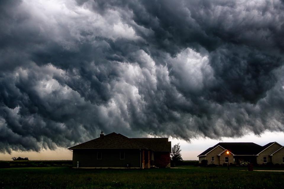
July 21st
 |
 |
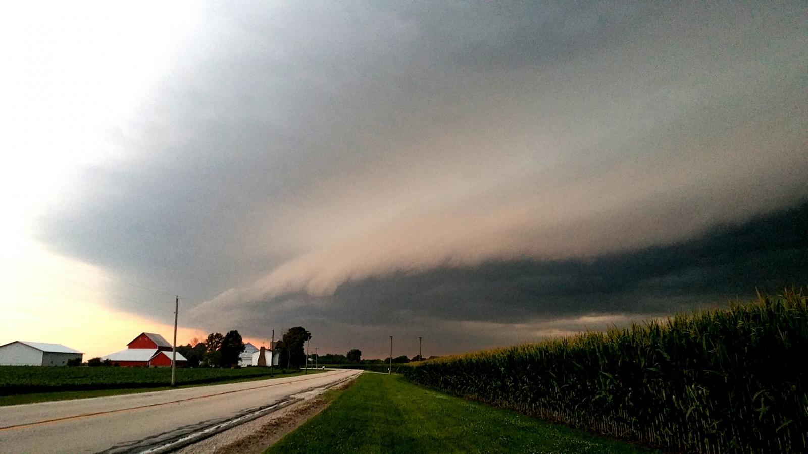 |
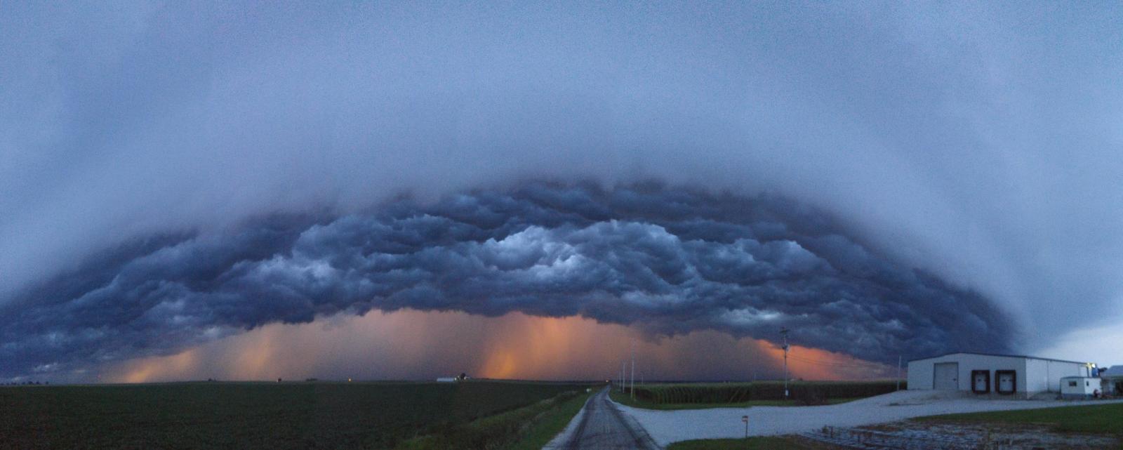
| Shelf Cloud Along Boone IL-Rock WI county line Tyler Sebree-WTVO |
Shelf Cloud S of DeKallb, IL Alex Hoffman |
Shelf Cloud SE of Hinckley, IL Bob Waszak |
 |
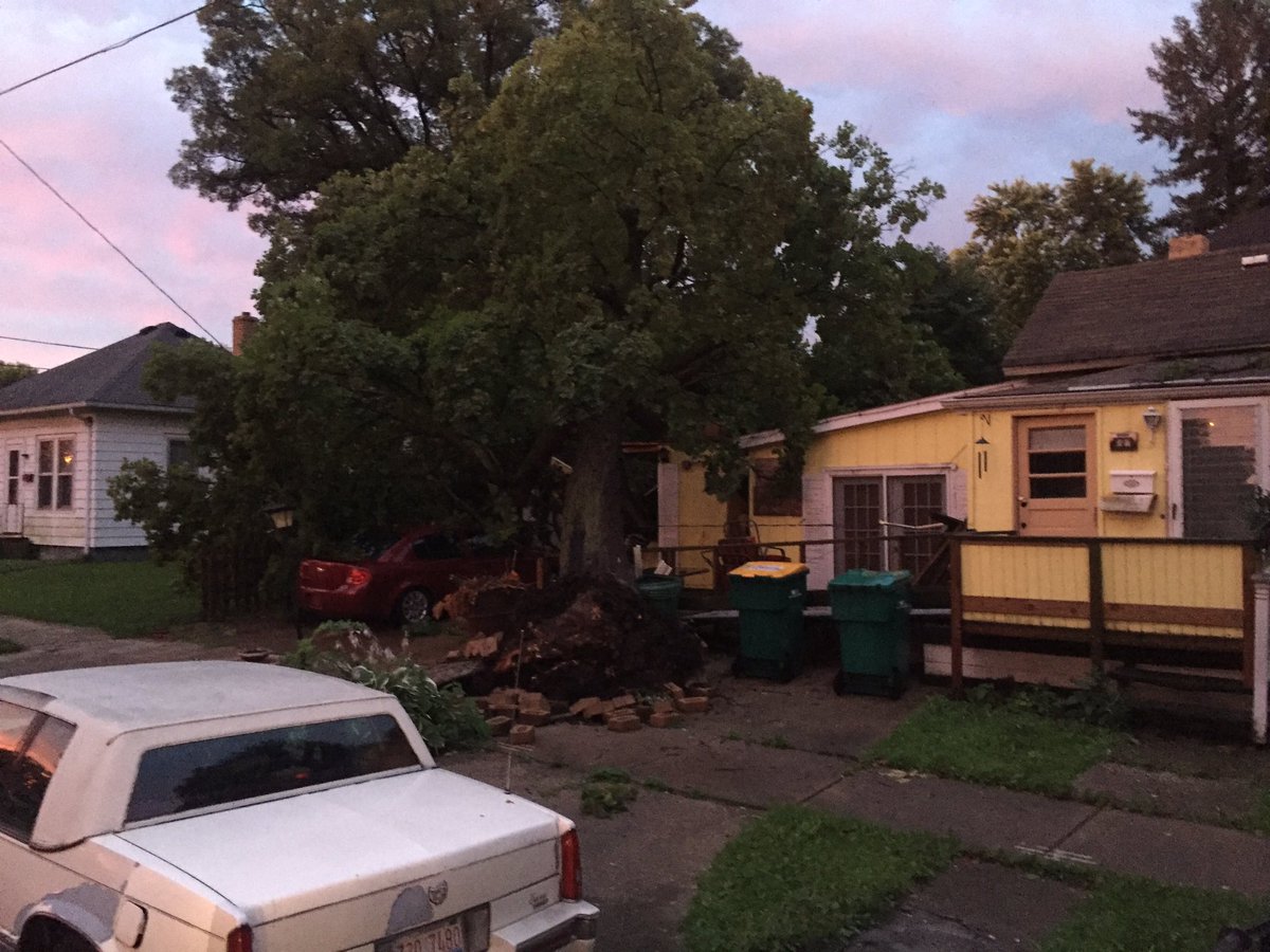 |
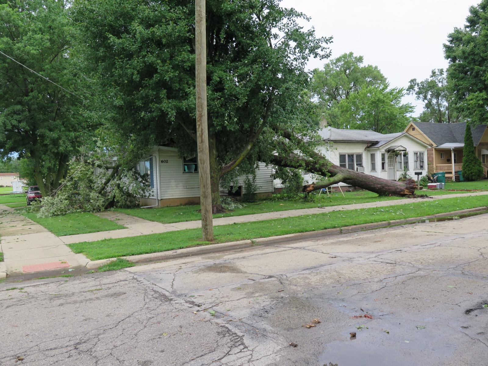
|
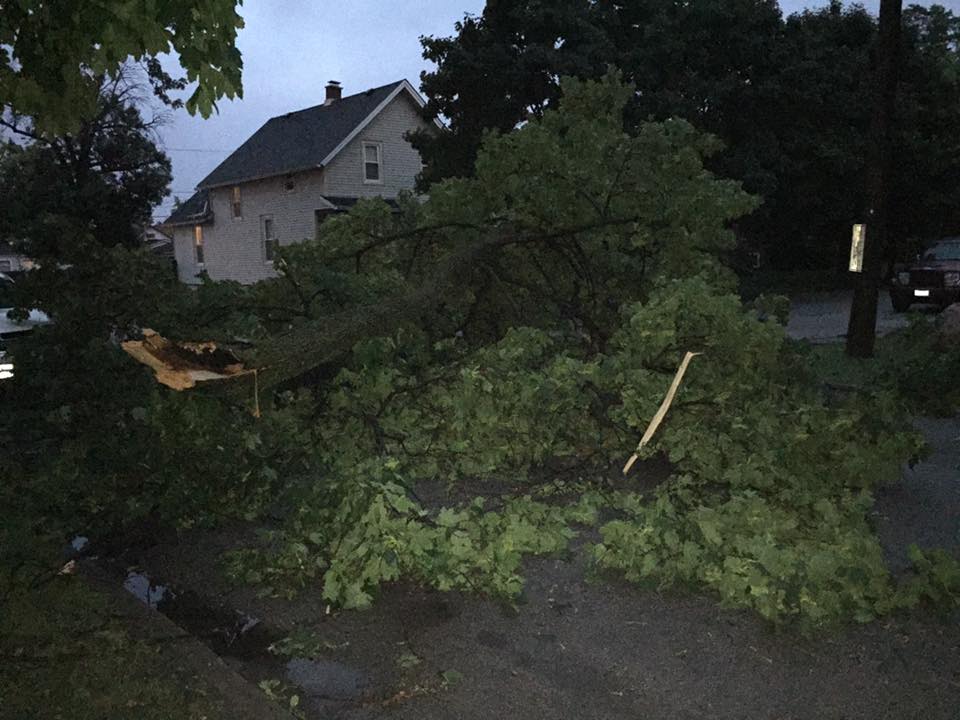
Wind Damage in Streator, IL Streator Fire Department |
Wind Damage in Streator, IL Streator Fire Department |
July 23rd
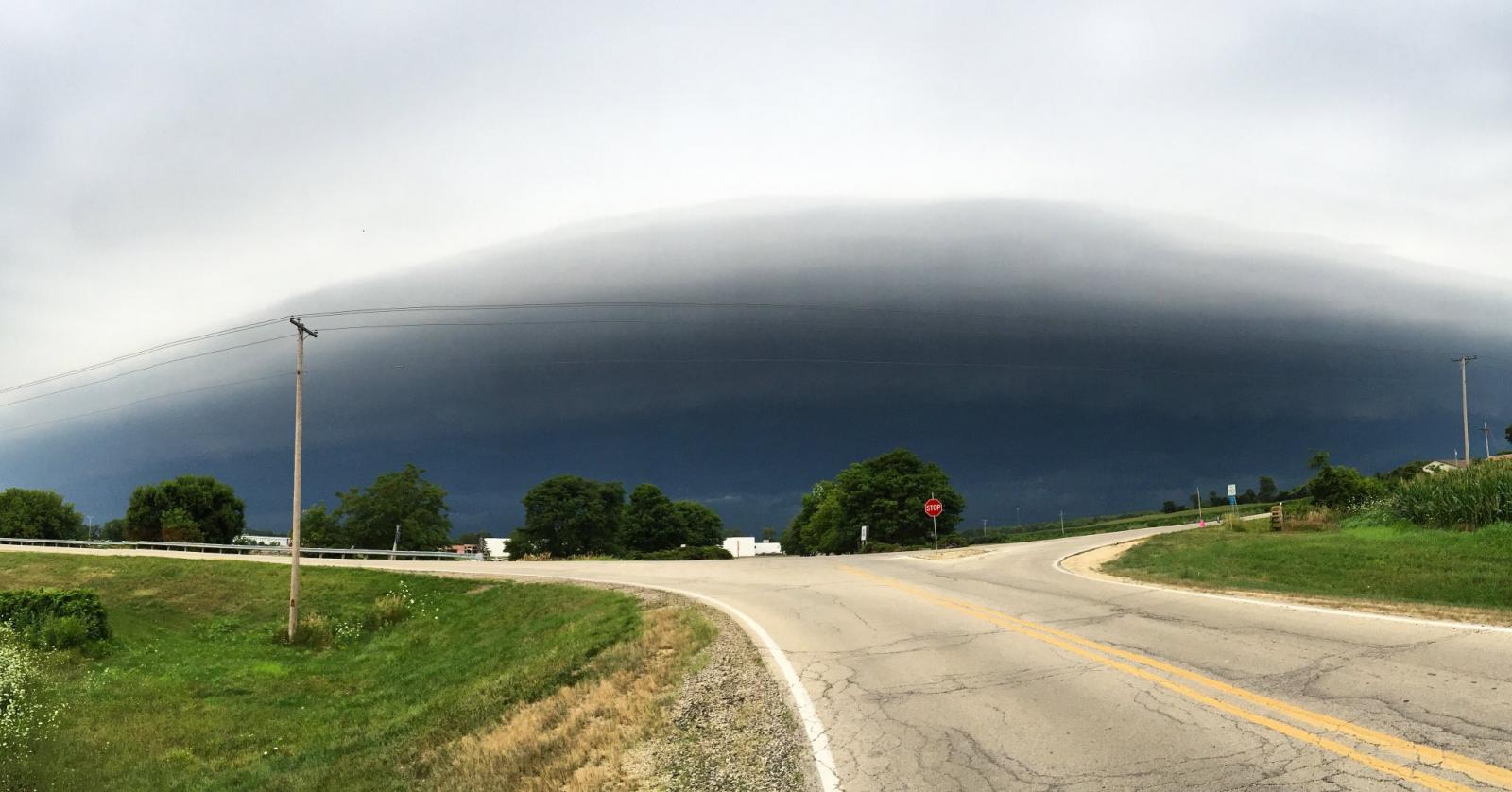
Shelf Clouds
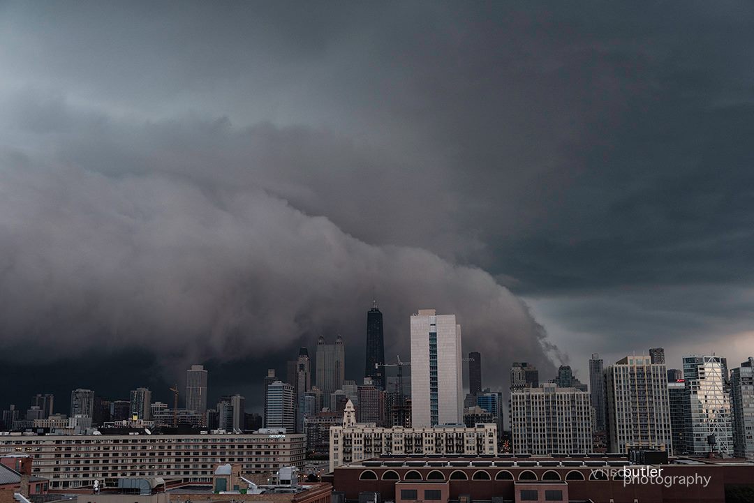 |
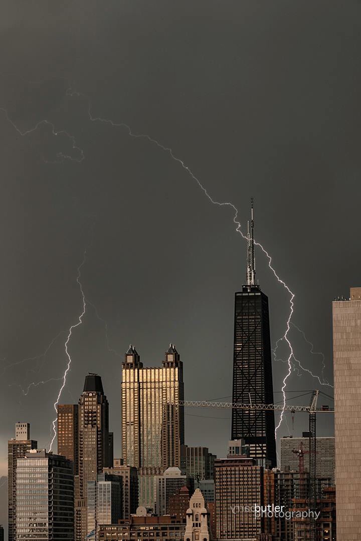
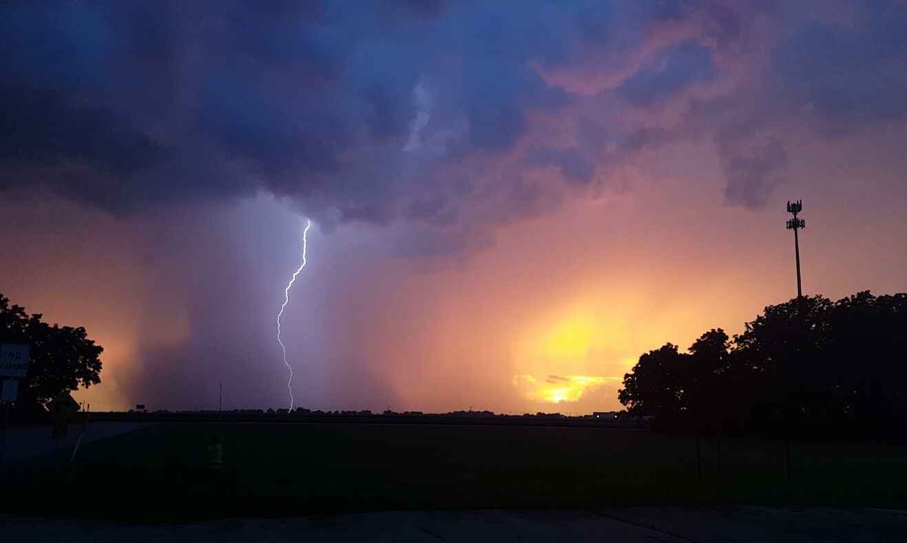
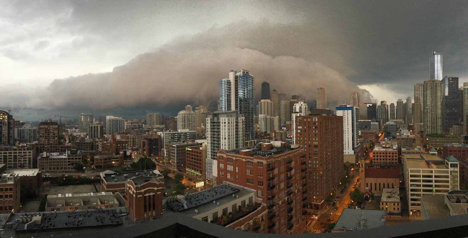 |
| Chicago (Barry Butler) |
Chicago (April Ann) |
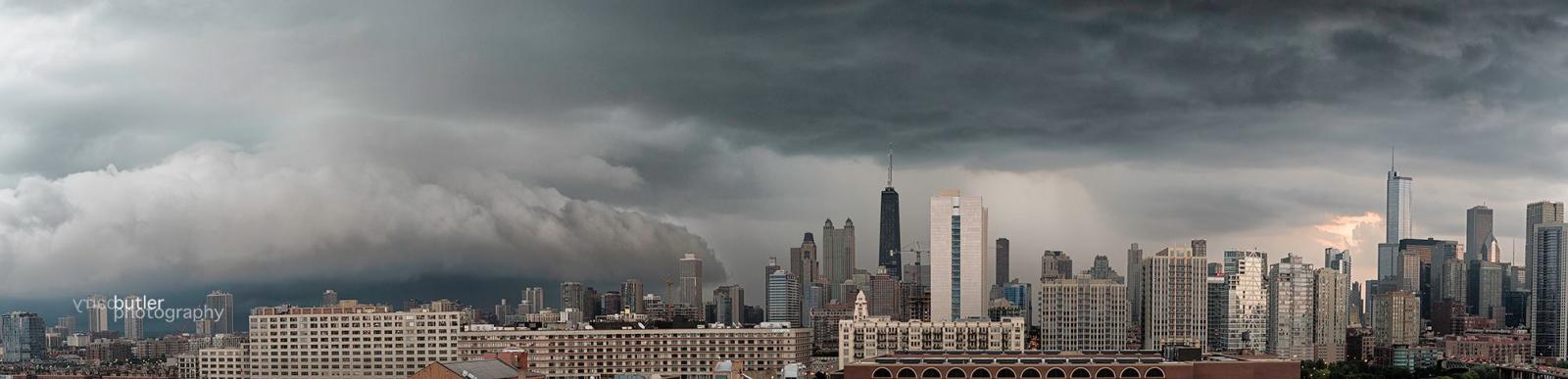 |
| Chicago (Barry Butler) |
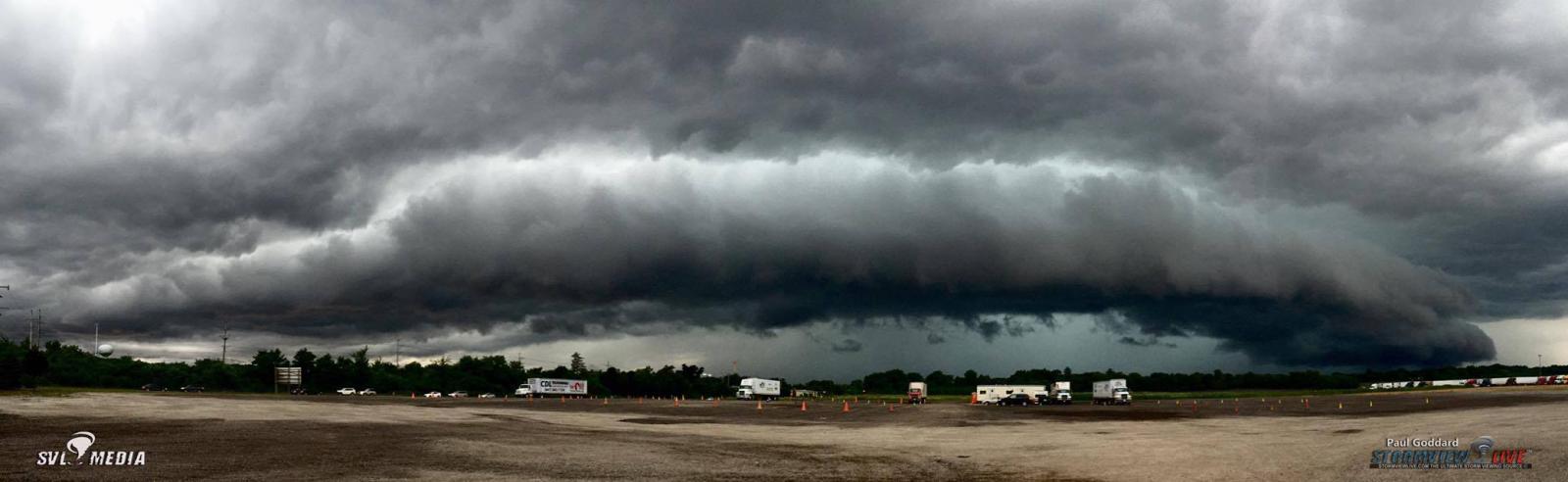 |
| West Dundee, IL (Paul Goddard) |
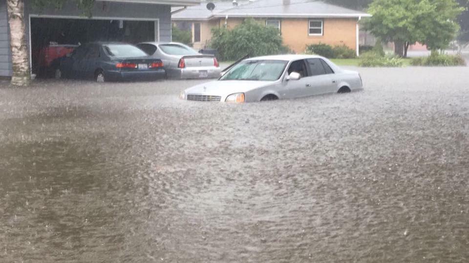
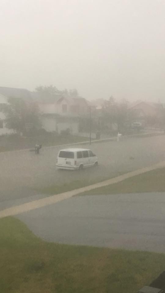
Flooding
 |
 |
|
| Belvidere (Sandra Leato) |
Cherry Valley - I39 & U.S. Highway 20 Lynn Rockcastle |
Belvidere (Kathleen Murphy-Sweet) |
July 24th
 |
 |
 |
| Chatsworth, IL Chris Dickerson |
Chicago, IL
|
Diamond, IL |
 |
 |
 |
| Kankakee, IL Shared through Twitter |
I-55 and I-294
|
Manteno, IL |
 |
 |
 |
| North side of Pontiac, IL Nichole Akre |
North side of Pontiac, IL
|
Hometown, IL |
 |
 |
 |
| Damage to an "L" train station in Chicago, IL |
South Loop in Chicago, IL
|
Blue Island, IL |
Heat Indices
Public Information Statement
National Weather Service Chicago IL
528 AM CDT MON JUL 25 2016 /628 AM EDT MON JUL 25 2016/

...Recap of hot and humid weekend with periods of thunderstorms...

Thursday July 21 through Sunday July 24, 2016 was a stretch of muggy
and occasionally stormy weather. Dewpoints crept into the upper 70s
to low 80s at times and high temperatures topped in the middle 90s
during this period. Gusty and even damaging winds occurred along
with very heavy rainfall, and lightning was abundant given the very
unstable atmosphere.

Below is a listing of maximum heat index values reported each day
for a few selected locations. Readings are in degrees F.

Location                     Thu   Fri   Sat   Sun
---------------------------------------------------------------
Gary Airport                 117   108   112   109
Pontiac Airport              116    98   109   117
Joliet Airport               114   100   106   115
Rockford Airport             110    99   100   112
De Kalb Airport              109    97   101   115
Morris Airport               109    95   101   113
Sugar Grove - Aurora Airport 109    99   103   115
Rochelle Airport             108    97   100   111
Peru Airport                 108    95   102   111
Rensselaer Airport           103    91   103   106
Dupage Airport               103    98   100   109
Chicago Midway               103    98   102   109
Romeoville - Lewis Aiprort   103    94   98    105
Chicago O`Hare               102    99   99    106
Valparaiso Airport           101    95   103   103
Wheeling - Chi Exec Airport  101    99   100   107
Lansing Airport              101    94   101   105
Waukegan Airport             99     99   99    110
Chicago Northerly Island     97     M    M     103
KMD/JEE/MTF
Summaries From Other NWS Offices
Thursday July 21st
Two rounds of thunderstorms moved through the region on Thursday, July 21st. The first grazed northeast Illinois and northwest Indiana, bringing isolated gusty winds and locally heavy rainfall. This also brought rain-cooled air into these areas, including downtown Chicago, which briefly brought relief from heat. The second round of storms was far more widespread and moved southward through the area that evening. Gusty winds and heavy rainfall were the main hazards, with reports of tree damage in isolated locations.
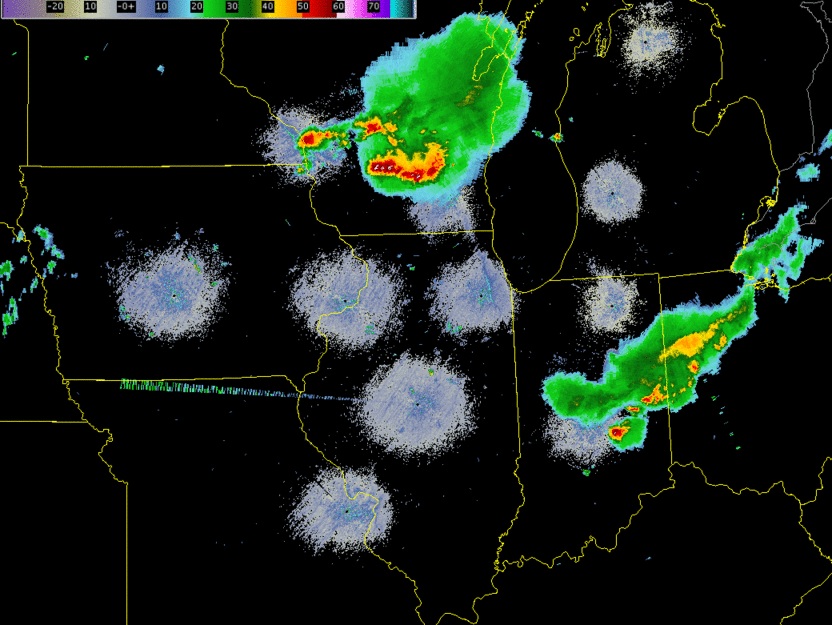 |
|
| Regional Radar Loop: 5:42 PM-12:00 AM CDT |
 |
 |
| Storm Reports | Rainfall |
 |
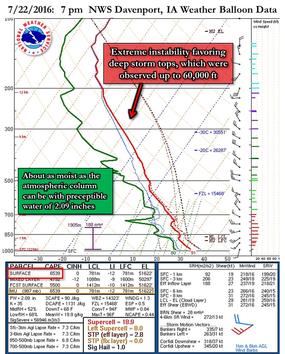 |
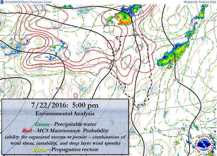
| Environmental Analysis at 5 pm Ahead of Main Thunderstorm Complex | 7 pm NWS Davenport, IA Weather Balloon Data |
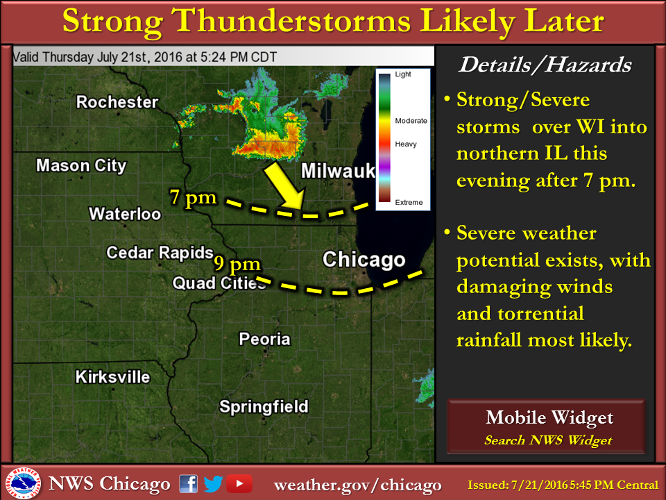 |
| NWS Chicago Graphical NOWcast issued at 5:45 pm |
Summaries From Other NWS Offices
Saturday July 23rd
|
An extremely humid and unstable air mass on Saturday July 23 set the stage for strong to severe storms to develop mid to late afternoon along the I-90 corridor in far northern Illinois. These storms ended up shifting very slowly southeast, bringing flash flooding to parts of Belvidere and Rockford, as well as near the Lake and Cook Counties border. Severe winds with gusts around 60 mph were scattered within this area. Another potent round of storms developed across northeast Iowa and moved eastward into northern Illinois around sunset. These brought isolated severe winds in north central Illinois as well as additional heavy rainfall. |
Shelf cloud on the leading edge of storms as they move into Chicago. Courtesy of Barry Butler. |
 |
 |
| Radar Loop: 4 pm - 1 am | Storm Reports |
 |
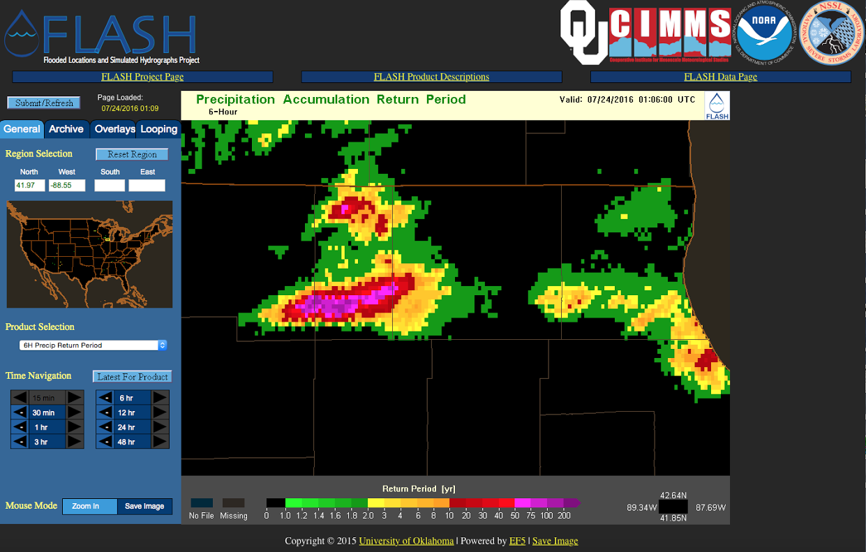 |
| Rain Reports | Average Recurrence Internal (ARI) giving an indication for how rare the rainfall totals were |
 |
| Environment |
 |
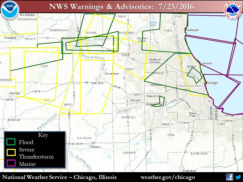 |
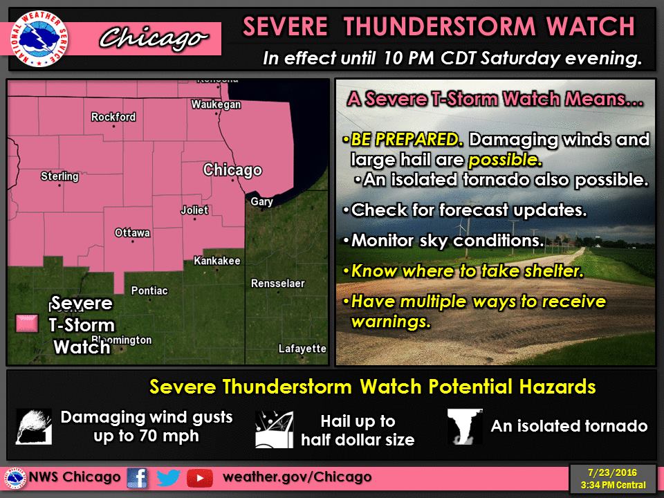
| NWS Severe Thunderstorm Watch | NWS Warnings & Advisories |
Other Links:
Sunday July 24th
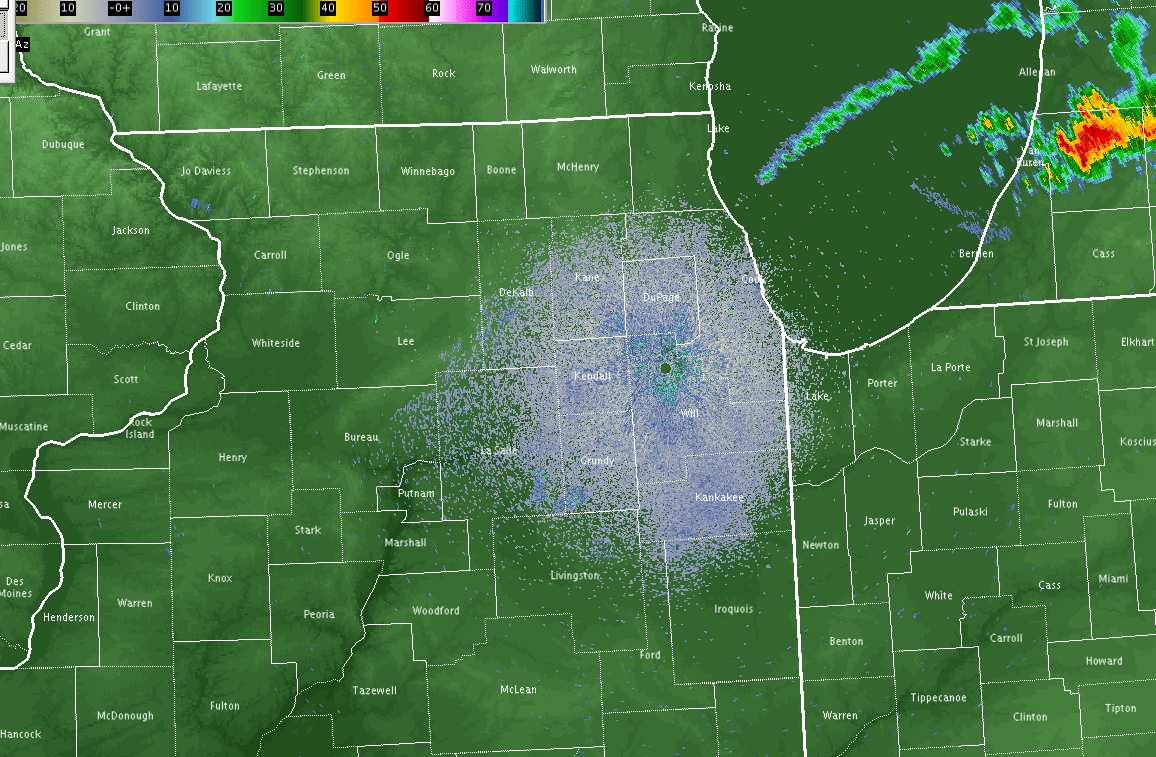 |
| Radar Loop: 3 pm - 1 a.m. |
 |
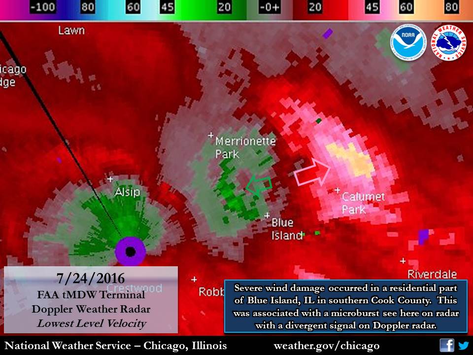 |
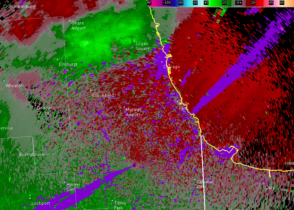
| Velocity from FAA Midway Terminal Doppler Weather Radar loop of strong winds in knots over Chicago, IL from 6:15 pm - 7:10 pm | Velocity from FAA Midway Terminal Doppler Weather Radar of ,icroburst in Blue Island, IL: 6:31 pm |
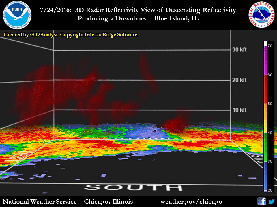 |
| 3D view from NWS Chicago Doppler Radar of microburst in Blue Island, IL. Images are about nine minutes apart from 6:13 pm through 6:31 pm. You can see the rapid descent of high reflectivity (many water droplets), and this signature in an environment favoring precipitation loading is indicative of a microburst. |
Dew Points
Public Information Statement
National Weather Service Chicago IL
1159 AM CDT TUE JUL 26 2016 /1259 PM EDT TUE JUL 26 2016/

...Extremely High Dew Points Observed on Sunday...

Dew points are a direct measure of moisture in the air, with
values in the 70s or higher associated with an oppressively humid
air mass. Sunday July 24th brought dew points in the upper 70s to
lower 80s across northern Illinois, which is basically at the
highest end of what can be observed. The setup for these extremely
humid conditions was ideal with a persistent warm air mass able
to hold ample water, southerly winds on Sunday advecting more
moisture into the area, wet ground and even standing water from
recent rains, and evapotranspiration from mature crops.

Here is a look at dew points in Rockford and Chicago and how they
compared to records and climatology:

-----------------------------------------------------------------

Rockford (KRFD)

The dew point peaked at 81 degrees at 7 pm on Sunday July 24th.

- A dew point of 81 degrees or higher has only been observed on
22 hourly observations since 1970. The last time was 8 pm on
August 2, 2011.

- There have only been three high dew point episodes (periods of
hours) with values that high since 1970. They were July 13-14
1995, July 29-30 1999, and August 2 2011.

- The highest dew point observed since 1970 was 83 degrees on July
13 1995.

-----------------------------------------------------------------

Chicago (KORD)

The dew point peaked at 78 degrees at 1 pm and 5 pm on Sunday
July 24th at Chicago`s official observing site of O`Hare
International Airport.

- The last time a dew point of 78 degrees or higher was observed
was on July 19, 2011. Prior to that was August 1 2002.

- The highest dew point observed in Chicago`s period of record
was 83 degrees on July 30 1999.

As a note, Chicago Midway International Airport had peaked at a
dew point of 79 degrees at 5 and 6 pm on Sunday July 24th. This
was the highest dew point observed at Midway since June 29 2012.


$$

MTF
 |
Media use of NWS Web News Stories is encouraged! Please acknowledge the NWS as the source of any news information accessed from this site. NWS Chicago Past Events Page |
|