.png) |
Overview
Service
 |
 |
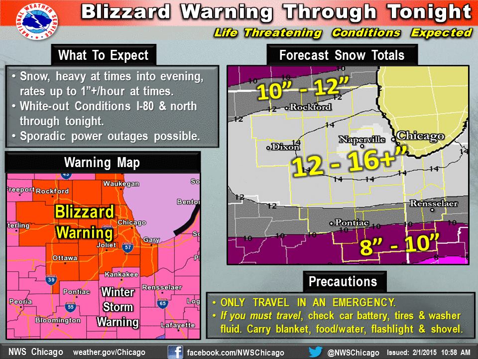 |
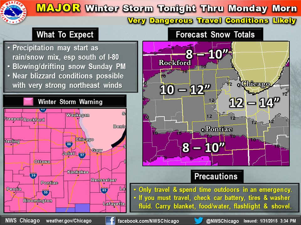
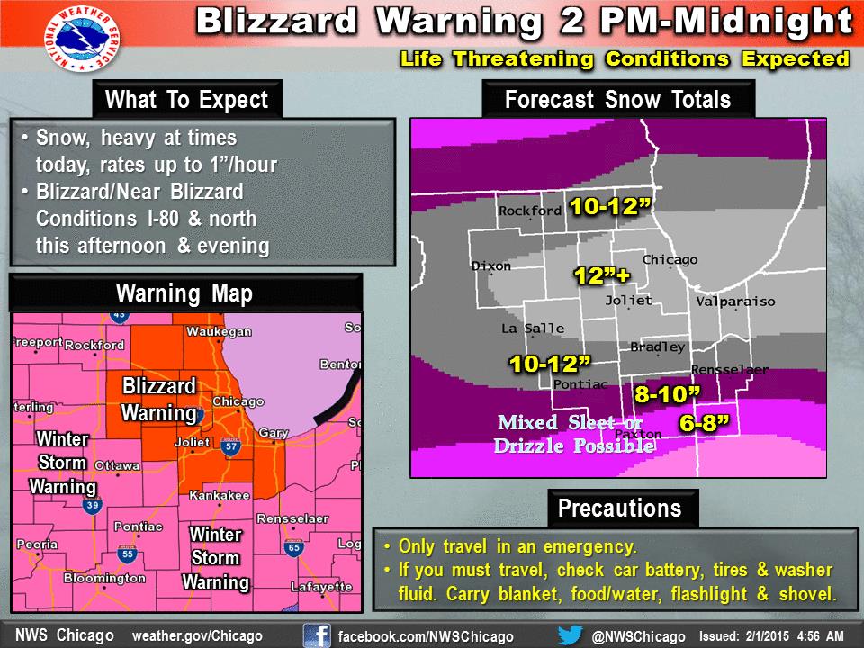
| Progression of NWS Chicago Weather Story graphics before and during the snowstorm | ||
.png) |
||
| Progression of NWS Warnings, Watches, and Advisories before and during the snowstorm | ||
Snowfall
|
|
 |
.png) |
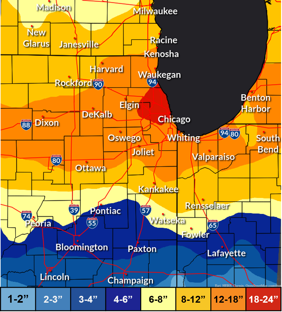
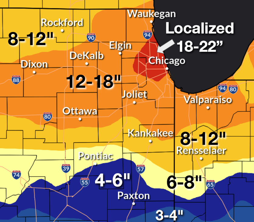
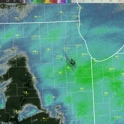
| Map of Approximate Snowfall Totals in the Region | Map of Approximate Snowfall Totals, Zoomed in on Northeast Illinois and Northwest Indiana | Visible satellite image showing the deep snow pack blanketing the region in the wake of the winter storm. Also, the lake effect snow band that resulted in the highest totals in the area being in Cook, Lake (IL), and DuPage counties, can clearly be seen extending into northwest Indiana. This brought occasional moderate to heavy snow to Porter County into the late morning of February 2nd. Most interestingly, strong convergence (winds of opposing directions coming together) allowed the band to extend all the way through Indiana into northern Kentucky! |
PUBLIC INFORMATION STATEMENT
NATIONAL WEATHER SERVICE CHICAGO/ROMEOVILLE IL
1150 AM CST MON FEB 02 2015

...2-DAY SNOWFALL ROUND-UP FROM THE HISTORIC JANUARY 31ST-
FEBRUARY 2ND 2015 SNOWSTORM...

THE FOLLOWING ARE SNOW AMOUNTS FOR THE PREVIOUS 2 DAYS
AS MEASURED IN THE MORNING BY NWS COOPERATIVE OBSERVERS
AND COCORAHS OBSERVERS. OBSERVATIONS ARE USUALLY TAKEN
BETWEEN 6AM AND 8AM. THANKS TO ALL THE OBSERVERS FOR
THEIR REPORTS DURING THIS HISTORIC SNOWSTORM!

  2-DAY SNOW TOTALS FOR MONDAY (02/02/15)
     AS OF 8:00 AM CST

ILLINOIS                                 2-DAY SNOW FALL
  LOCATION (COUNTY):                         AMT(IN) REPORTS

  LINCOLNSHIRE 1N (LAKE).......................22.0     (2)
  OAK LAWN (COOK)..............................21.5     (2)
  ELMHURST (DU PAGE)...........................20.8     (2)
  ROGERS PARK 2SW (COOK).......................20.0     (2)
  LINCOLNWOOD 3E (COOK)........................19.7     (2)
  LINCOLNWOOD 2E (COOK)........................19.5     (2)
  OHARE (COOK).................................19.3     (2)
  WINFIELD (DU PAGE)...........................19.2     (2)
  MIDWAY COOP (COOK)...........................19.2     (2)
  DOWNERS GROVE 0.4NNE (DU PAGE)...............19.1     (2)
  PARK FOREST (COOK)...........................18.7     (2)
  SCHAUMBURG  2E (COOK)........................18.7     (2)
  ELMHURST 1ESE (DU PAGE)......................18.6     (2)
  LAKE FOREST 2NNE (LAKE)......................18.5     (2)
  BURR RIDGE 2SW (DU PAGE).....................18.5     (2)
  HIGHWOOD 1S (LAKE)...........................18.3     (2)
  LOMBARD 1NNW (DU PAGE).......................18.2     (2)
  WINNETKA 1ESE (COOK).........................18.1     (2)
  HARVARD 3SSE (MCHENRY).......................18.0     (2)
  ROSELLE 1W (DU PAGE).........................18.0     (2)
  OAK PARK 1NNE (COOK).........................18.0     (2)
  ELK GROVE VILLAGE 1ESE (COOK)................18.0     (2)
  HOFFMAN ESTATES 5W (COOK)....................18.0     (2)
  HARWOOD HEIGHTS 2NNE (COOK)..................17.5     (2)
  WESTMONT (DU PAGE)...........................17.5     (2)
  OAK PARK 2S (COOK)...........................17.5     (2)
    MARSEILLES 6WNW (LA SALLE)...................17.5     (2)
  DARIEN (DU PAGE).............................17.2     (2)
  PLAINFIELD 5SW (KENDALL).....................16.8     (2)
  BATAVIA (KANE)...............................16.8     (2)
  BUFFALO GROVE 2N (LAKE)......................16.7     (2)
  NORTH AURORA 2NE (KANE)......................16.6     (2)
  LOCKPORT 1SE (WILL)..........................16.5     (2)
  ST. CHARLES (KANE)...........................16.5     (2)
  COUNTRYSIDE 1ENE (COOK)......................16.5     (2)
  ELBURN (KANE)................................16.5     (2)
  GENEVA 4WSW (KANE)...........................16.4     (2)
  GENEVA 2WSW (KANE)...........................16.2     (2)
  MANHATTAN (WILL).............................16.0     (2)
  NEW LENOX 3E (WILL)..........................16.0     (2)
  NEW LENOX 2SE (WILL).........................16.0     (2)
  MANHATTAN 5ENE (WILL)........................16.0     (2)
  OTTAWA 2N (LA SALLE).........................16.0     (2)
  HOMEWOOD (COOK)..............................16.0     (2)
  SCHAUMBURG 3WSW (COOK).......................16.0     (2)
  DE KALB (DE KALB)............................15.9     (2)
  PLAINFIELD 2SSE (WILL).......................15.8     (2)
  RIVERWOODS (LAKE)............................15.7     (2)
  JOLIET 2N (WILL).............................15.6     (2)
  LAKE ZURICH (LAKE)...........................15.5     (2)
  SUGAR GROVE 1NE (KANE).......................15.5     (2)
  MUNDELEIN (LAKE).............................15.4     (2)
  PAW PAW (LEE)................................15.3     (2)
  ROMEOVILLE (WILL)............................15.3     (2)
  CAROL STREAM (DU PAGE).......................15.3     (2)
  PARK RIDGE 1WNW (COOK).......................15.3     (2)
  MORRIS (GRUNDY)..............................15.2     (2)
  MONTGOMERY 1SSE (KENDALL)....................15.1     (2)
  LILY LAKE 2E (KANE)..........................15.0     (2)
  LA GRANGE PARK 1SSW (COOK)...................15.0     (2)
  CHICAGO RIDGE (COOK).........................15.0     (2)
  AURORA (KANE)................................15.0     (2)
  SHERIDAN 3SSE (LA SALLE).....................14.7     (2)
  NAPERVILLE 1NW (DU PAGE).....................14.7     (2)
  PEOTONE (WILL)...............................14.6     (2)
  NEW LENOX 1NE (WILL).........................14.5     (2)
  MARSEILLES 3NW (LA SALLE)....................14.5     (2)
  ASHTON (LEE).................................14.5     (2)
  ELGIN 2W (KANE)..............................14.5     (2)
  BOURBONNAIS 2NNE (KANKAKEE)..................14.5     (2)
  GLEN ELLYN 2SSE (DU PAGE)....................14.5     (2)
  BOLINGBROOK 3NE (DU PAGE)....................14.5     (2)
  PARK RIDGE (COOK)............................14.5     (2)
  ROCKFORD 3NE (WINNEBAGO).....................14.4     (2)
  SPRING GROVE 2N (MCHENRY)....................14.2     (2)
  PALATINE 1E (COOK)...........................14.1     (2)
  ROCHELLE (OGLE)..............................14.0     (2)
  MARSEILLES (LA SALLE)........................14.0     (2)
  ELBURN 3NNE (KANE)...........................14.0     (2)
  MINOOKA (GRUNDY).............................14.0     (2)
  PARK FOREST 1SW (COOK).......................14.0     (2)
  ELGIN (KANE).................................14.0     (2)
  CARY (MCHENRY)...............................13.8     (2)
  ELK GROVE VILLAGE 2WSW (COOK)................13.8     (2)
  WORTH (COOK).................................13.7     (2)
  MCHENRY (MCHENRY)............................13.5     (2)
  MUNDELEIN 2WNW (LAKE)........................13.5     (2)
  LAKE VILLA 1SSW (LAKE).......................13.5     (2)
  AURORA 4SE (DU PAGE).........................13.5     (2)
  LA SALLE (LA SALLE)..........................13.4     (2)
  WAUKEGAN 2N (LAKE)...........................13.3     (2)
  BULL VALLEY 2WNW (MCHENRY)...................13.2     (2)
  OTTAWA 1NW (LA SALLE)........................13.0     (2)
  MENDOTA (LA SALLE)...........................13.0     (2)
  PLAINFIELD 1SW (WILL)........................13.0     (2)
  GURNEE 2W (LAKE).............................13.0     (2)
  PALOS PARK 1SW (COOK)........................13.0     (2)
  HARVARD (MCHENRY)............................13.0     (2)
  MAZON 0.5ENE (GRUNDY)........................12.5     (2)
  ALSIP (COOK).................................12.5     (2)
  CRETE 3E (WILL)..............................12.3     (2)
  ROCKFORD (WINNEBAGO).........................12.1     (2)
  MALTA (DE KALB)..............................12.0     (2)
  BELVIDERE (BOONE)............................12.0     (2)
  STEWARD (LEE)................................11.6     (2)
  CARBON HILL 3.1N (GRUNDY)....................11.3     (2)
  GENOA (DE KALB)..............................11.3     (2)
  COAL CITY 4NNW (GRUNDY)......................11.3     (2)
  BEACH PARK 1W (LAKE).........................11.1     (2)
  ST. CHARLES 6NW (KANE).......................11.1     (2)
  LAKE VILLA 2WSW (LAKE).......................11.0     (2)
  ELGIN 1S (KANE)..............................10.4     (2)
  ELGIN (KANE).................................10.4     (2)
  DIXON 2SW (LEE)..............................10.3     (2)
  ST ANNE (KANKAKEE)...........................10.0     (2)
  STREATOR 1WSW (LA SALLE).....................10.0     (2)
  CAPRON (BOONE)...............................10.0     (2)
  MUNDELEIN (LAKE)..............................9.8     (2)
  ROCKFORD 1NW (WINNEBAGO)......................9.7     (2)
  ROSCOE 2SE (WINNEBAGO)........................9.4     (2)
  ROSCOE 2ESE (WINNEBAGO).......................9.4     (2)
  BOURBONNAIS (KANKAKEE)........................9.2     (2)
  PONTIAC (LIVINGSTON)..........................8.7     (2)
  CORTLAND (DE KALB)............................8.6     (2)
  STREATOR 4ENE (LA SALLE)......................7.8     (2)
  ASHKUM 5.6E (IROQUOIS)........................7.6     (2)
  PAXTON (FORD).................................7.0     (2)
  WATSEKA 6.9WNW (IROQUOIS).....................7.0     (2)
  COAL CITY (GRUNDY)............................6.6     (2)
  DWIGHT (LIVINGSTON)...........................6.5     (2)
  FAIRBURY (LIVINGSTON).........................5.4     (2)
  MILFORD (IROQUOIS)............................4.9     (2)
  CHATSWORTH (LIVINGSTON).......................3.5     (2)

INDIANA                                    2-DAY SNOW FALL
  LOCATION (COUNTY):                         AMT(IN) REPORTS

  HOBART 1NNW (LAKE)...........................17.0     (2)
  CROWN POINT 2WSW (LAKE)......................16.5     (2)
  LAKES OF THE FOUR SEASONS 2NNE (PORTER)......16.0     (2)
  VALPARAISO 6SSW (PORTER).....................16.0     (2)
  VALPARAISO 1SE (PORTER)......................15.5     (2)
  CROWN POINT 1N (LAKE)........................15.4     (2)
  PORTER 1S (PORTER)...........................14.4     (2)
  VALPARAISO 6WSW (PORTER).....................14.0     (2)
  DYER 1WNW (LAKE).............................13.9     (2)
  DE MOTTE 1SSW (JASPER).......................13.5     (2)
  HEBRON 4NE (PORTER)..........................13.0     (2)
  GARY 5ENE (LAKE).............................13.0     (2)
  HOBART 2E (LAKE).............................13.0     (2)
  DE MOTTE 1NNW (JASPER).......................12.5     (2)
  VALPARAISO 1NNW (PORTER).....................11.0     (2)
  VALPARAISO 3WSW (PORTER).....................11.0     (2)
  MOROCCO (NEWTON).............................10.0     (2)
  (W9OPR)WHEATFIELD 1ENE (JASPER)..............10.0     (2)
  REMINGTON (JASPER)...........................10.0     (2)
  RENSSELAER 2SSW (JASPER).....................10.0     (2)
  VALPARAISO 4SW (PORTER).......................9.8     (2)
  DE MOTTE 4SW (JASPER).........................9.5     (2)
  DE MOTTE 6S (JASPER)..........................9.0     (2)
  LAKE VILLAGE (NEWTON).........................8.6     (2)
  RENSSELAER (JASPER)...........................8.5     (2)
  REMINGTON (JASPER)............................7.7     (2)
  MOUNT AYR 2NNE (NEWTON).......................4.6     (2)

$$
Peak Winds
PUBLIC INFORMATION STATEMENT
NATIONAL WEATHER SERVICE CHICAGO IL
137 PM CST MON FEB 2 2015

...HIGHEST WIND GUSTS DURING THE JAN 31-FEB 2 2015 WINTER STORM...

LOCATION                     SPEED     TIME/DATE

3 ESE WAUKEGAN               52 MPH    1140 PM 02/01
2 N SHOREWOOD                49 MPH    0454 PM 02/01
CHICAGO HARRISON-DEVER CRIB  48 MPH    0915 PM 02/01
GARY CHICAGO INTRNTL AIRPORT 47 MPH    0445 AM 02/02
3 WNW MICHIGAN CITY          46 MPH    1100 PM 02/01
1 SW DOUGLAS PARK            45 MPH    0836 PM 02/01
CHICAGO/ROCKFORD INTERNATION 44 MPH    0708 PM 02/01
WAUKEGAN REGIONAL AIRPORT    44 MPH    1105 PM 02/01
DUPAGE AIRPORT               44 MPH    0300 PM 02/01
AURORA MUNICIPAL AIRPORT     43 MPH    0238 PM 02/01
2 SSE STEWARD                43 MPH    0825 PM 02/01
PAXTON                       43 MPH    0740 PM 02/01
2 ENE WAUKEGAN               43 MPH    0255 PM 02/01
1 SE WINNEBAGO               42 MPH    0702 PM 02/01
1 W PONTIAC                  42 MPH    1025 PM 02/01
1 E SYCAMORE                 42 MPH    0341 PM 02/01
2 NE PALATINE                42 MPH    0841 PM 02/01
2 WNW DIXON                  41 MPH    0239 PM 02/01
1 NNE CRYSTAL LAKE           41 MPH    1157 AM 02/01
1 SE LAKE BLUFF              40 MPH    0825 PM 02/01
1 SE LA SALLE                40 MPH    0310 PM 02/01
DE KALB                      39 MPH    0335 PM 02/01
SOUTH CHICAGO                39 MPH    1036 PM 02/01
CHICAGO OHARE INTL AP        39 MPH    0430 PM 02/01
PONTIAC                      39 MPH    0535 PM 02/01
CHICAGO MIDWAY AIRPORT       38 MPH    0726 PM 02/01
ELMHURST                     38 MPH    0225 PM 02/01
2 W GENEVA                   38 MPH    0340 PM 02/01
2 W COLLEGEVILLE             38 MPH    0901 PM 02/01
CHICAGO EXECUTIVE AIRPORT    37 MPH    0915 PM 02/01
ROCHELLE                     37 MPH    0315 PM 02/01
CHEBANSE                     37 MPH    0640 PM 02/01
2 E HARWOOD HEIGHTS          37 MPH    0555 PM 02/01
1 WNW NEW CHICAGO            37 MPH    1246 AM 02/02
GLENVIEW                     36 MPH    0340 PM 02/01
1 ESE SYCAMORE               36 MPH    0300 PM 02/01
ELBURN                       36 MPH    0400 PM 02/01
2 WSW SHERIDAN               36 MPH    0205 PM 02/01
1 ESE LAKEWOOD               36 MPH    1120 AM 02/01
2 E NEW MILLFORD             36 MPH    1025 PM 02/01
2 ESE LOCKPORT               36 MPH    0325 PM 02/01
1 ENE ROCKDALE               36 MPH    0340 PM 02/01
MOUNT PROSPECT               36 MPH    0325 PM 02/01
1 ESE HIGHLAND PARK          36 MPH    0425 PM 02/01
GREATER KANKAKEE AIRPORT     35 MPH    0835 PM 02/01
1 NNW GLENCOE                35 MPH    0949 PM 02/01
SUBLETTE                     35 MPH    0342 PM 02/01
2 ESE DIXON                  35 MPH    0308 PM 02/01

OBSERVATIONS ARE COLLECTED FROM A VARIETY OF SOURCES WITH VARYING
EQUIPMENT AND EXPOSURE. NOT ALL DATA LISTED ARE CONSIDERED OFFICIAL.

$$
Historical Context
 |
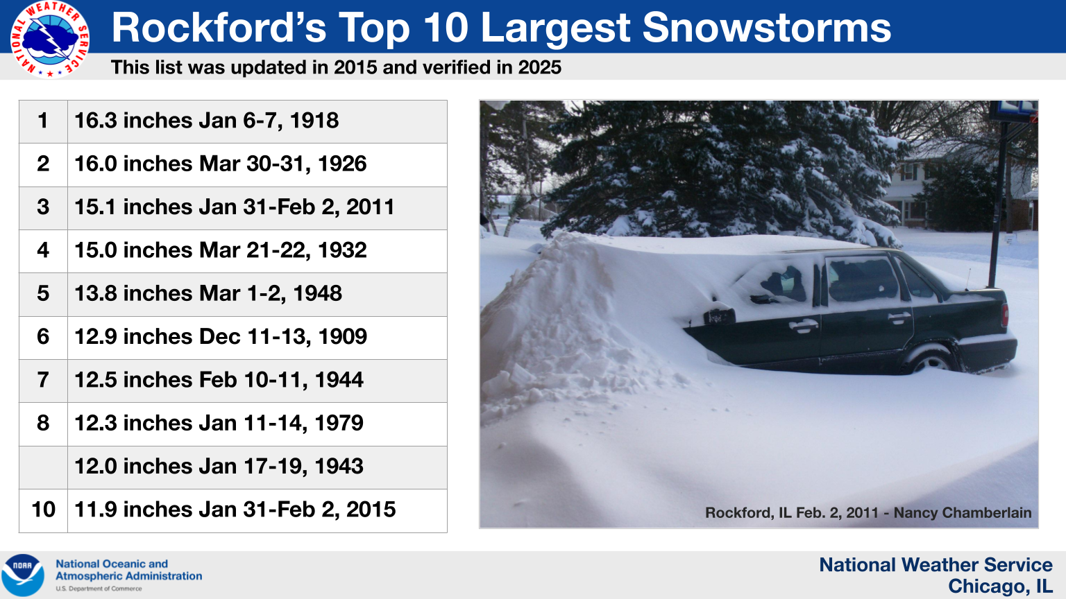 |
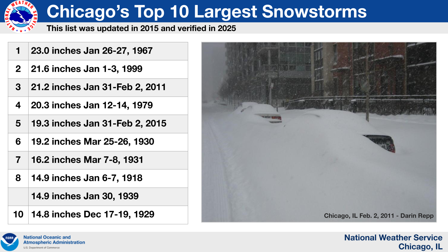
| The 19.3 inches of snow that were observed at O'Hare Airport during this winter storm made it Chicago's 5th largest snowstorm on record (by total snowfall accumulation). Official snowfall records for Chicago date back to 1884. | The 11.9 inches of snow that were observed at Rockford Airport during this winter storm made it Rockford's 10th largest snowstorm on record (by total snowfall accumulation). Official snowfall records for Rockford date back to 1905. |
The above top 10 rankings are valid as of February 1, 2025.
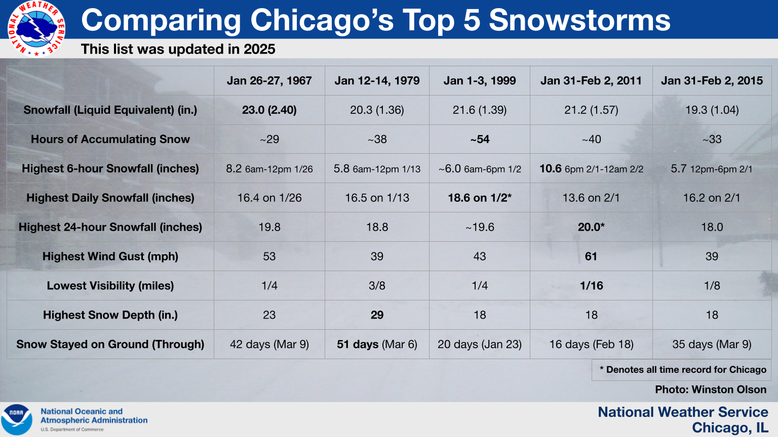 |
| How the 2015 winter storm compares to other historic winter storms that impacted Chicago. The table in this graphic was updated in 2025 with the assistance of local weather historian Frank Wachowski. |
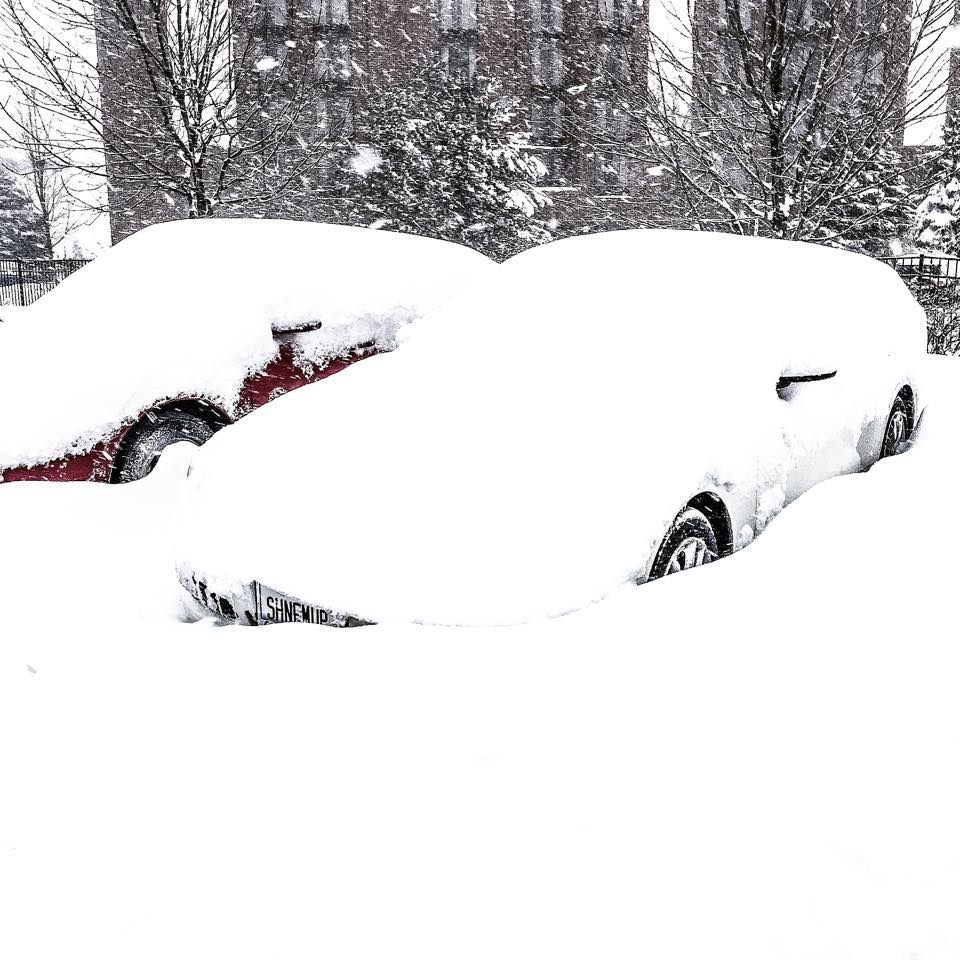
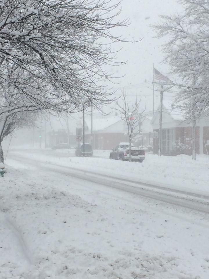
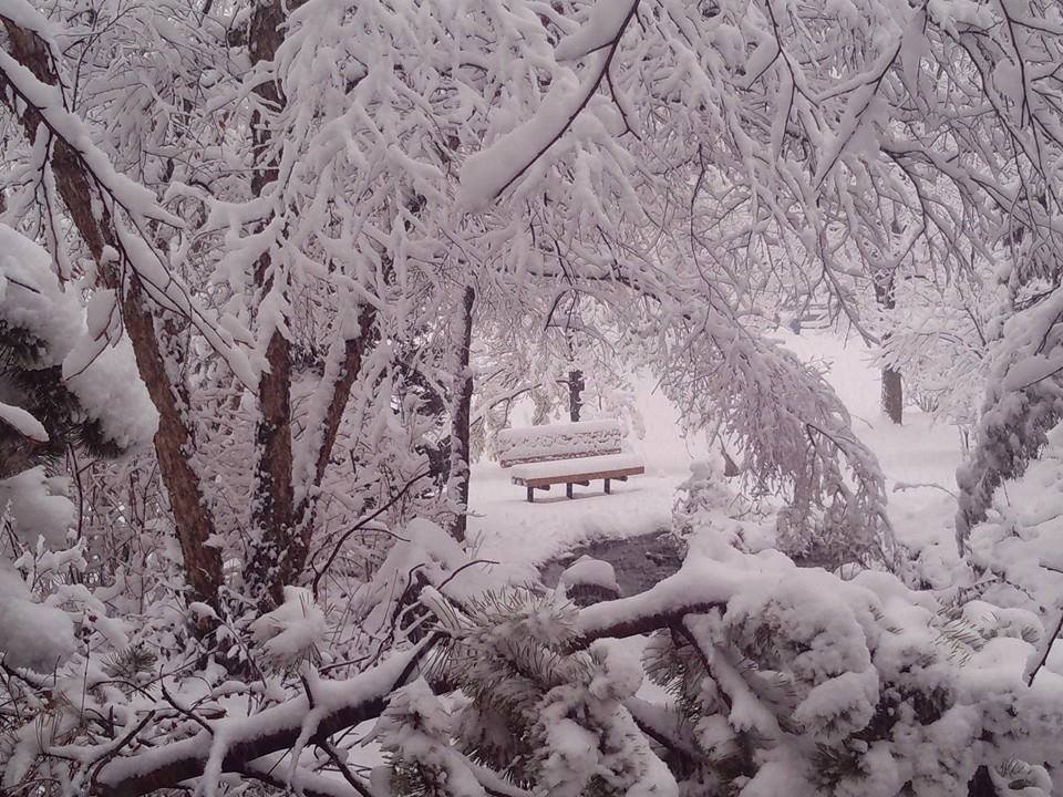
Photos
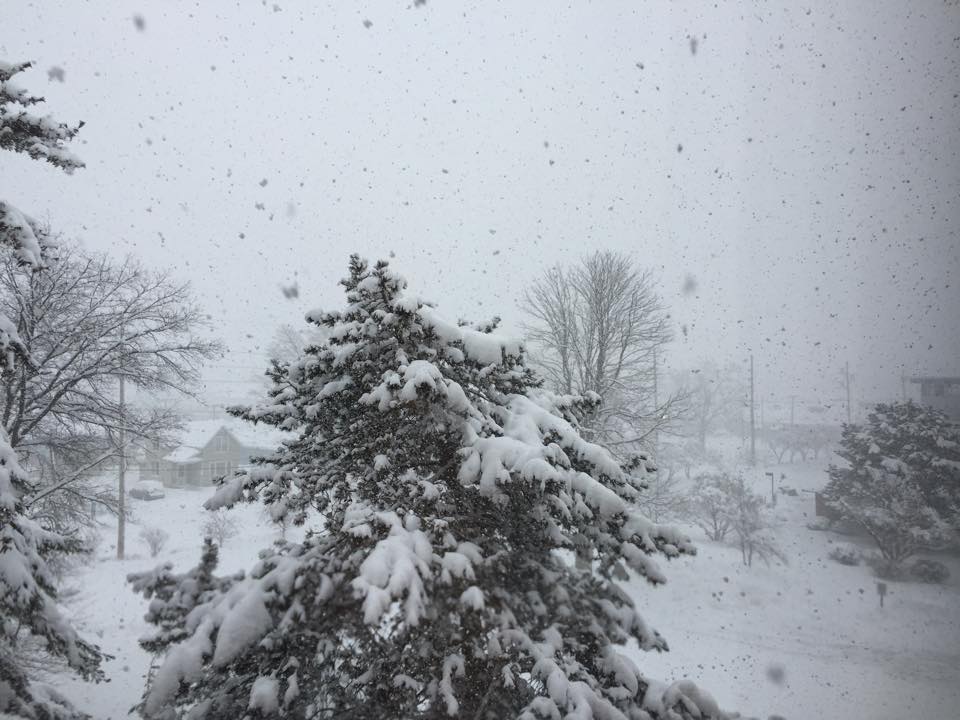
.jpg) |
.jpg) |
.jpg) |
| Low visibility at the NWS Chicago office in Romeoville, IL. | Low visibility at the NWS Chicago office in Romeoville, IL. | Deep snow cover at the NWS Chicago office in Romeoville, IL on February 2nd. |
 |
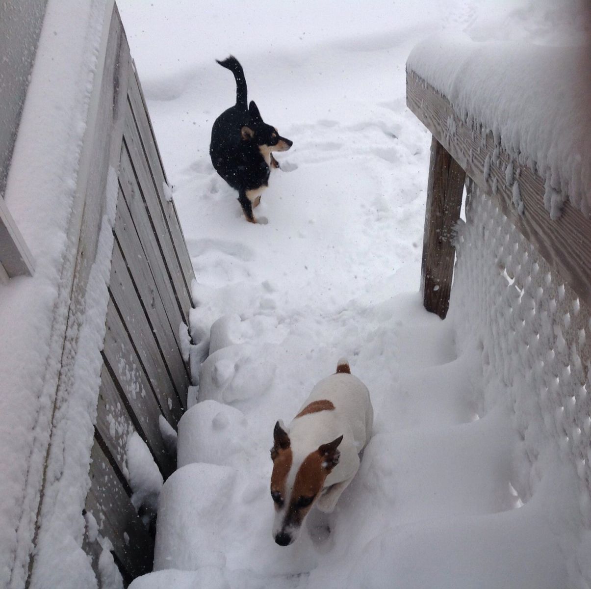 |
 |
| Lombard, IL. Photo courtesy of Erika Hoffmann. | Chicago, IL. Photo courtesy of Diane O'Malley-Krzywonos. | Photo courtesy of Paul Goddard. |
 |
 |
 |
| Palos Heights, IL. Photo courtesy of Christine McEvilly. | West Loop, Chicago, IL. Photo courtesy of Michael Lyons. | Valparaiso, IN. Photo courtesy of Winston Olson. |
Winter Storm Photo Album on Facebook
Radar
 |
.gif) |
| Local radar loop from 10:00 AM CST through 4:30 AM CST on 2/1/15. | Regional radar loop from 3:00 PM CST 1/31/15 through 9:00 AM CST 2/2/15. |
Meteorology
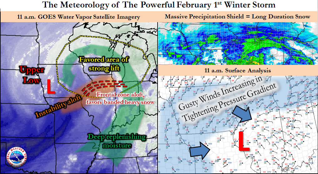
Several ingredients came together to produce this significant snowfall. A deepening center of low pressure lifting from the Southern Plains through the Ohio Valley pulled rich moisture out of the tropical Pacific Ocean and the Gulf of America and wrapped it into cold Arctic air. Early in the event, the relatively mild surface temperatures in the 30s kept snow-to-liquid ratios on the lower end of the spectrum, or close to 10-to-1. As the event progressed and colder air spread into the region, the snow evolved from wet and heavy to very light and fluffy as ratios eventually increased to 30-to-1 or higher. At O'Hare, the liquid precipitation total of 0.87" on Sunday was a record for February 1st, exceeding the previous record of 0.77" measured during the Groundhog Day Blizzard of 2011. Had snow-to-liquid ratios been higher earlier in this event, snowfall totals could have approached or exceeded those from the 2011 event.
A tightening pressure gradient around the low center as it moved from central Illinois into central Indiana also supported strong and gusty northeast winds later Sunday afternoon into the evening, producing a period of blizzard to near-blizzard conditions with gusts over 35 mph and visibilities around 1/4 mile or less in many locations.
 |
|
| Meteorological summary graphic | |
.png) |
.gif) |
| Upper air sounding from Davenport, IA taken at 6 AM CST on February 1st | Satellite water vapor imagery loop showing the weather system tracking into the Midwest |
Additional Information
Links
 |
Media use of NWS Web News Stories is encouraged! Additional event recaps can be found on the NWS Chicago Science & Past Events Page. |
|