Observations of Snow | Meteorology | Latest Observed Snowfall | Temperatures
Observations of Snow This Morning
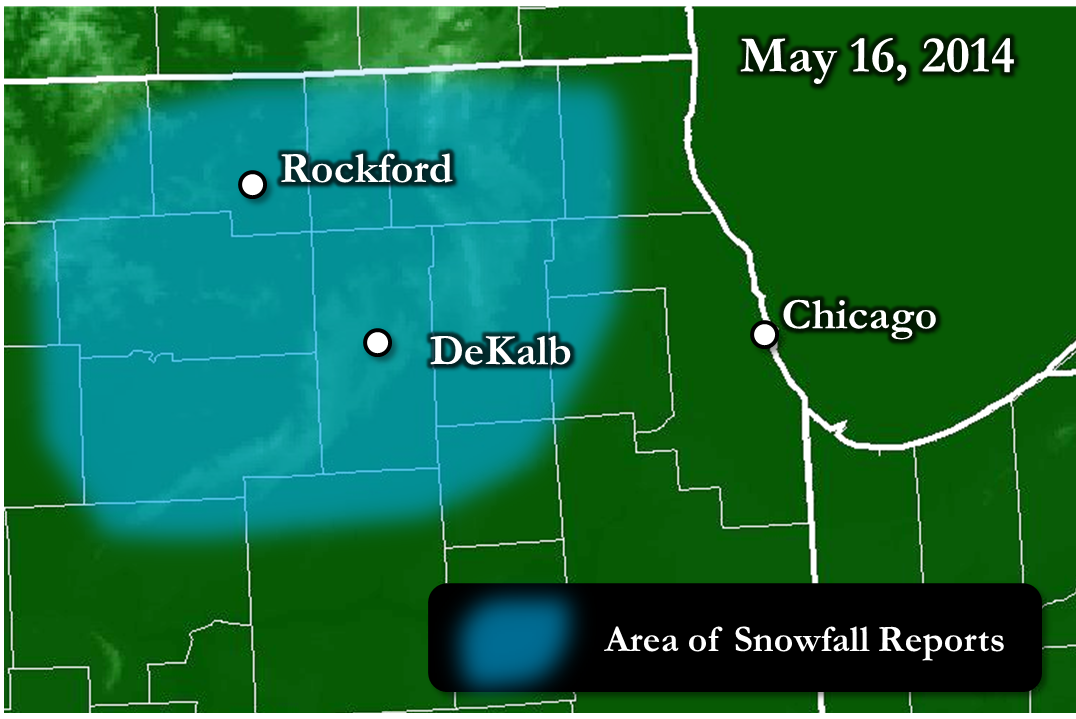
Locations include: Ashton, Cortland, Crystal Lake, DeKalb, Franklin Grove, Gilberts, Malta, Mendota, Mundelein, Paw Paw, Rochelle, Rockford, Sandwich, Streamwood, and others.
A very cool Thursday Night set the stage, with temperatures in the 40s falling into the 30s in some places overnight. As temperatures cooled in the lowest few thousand feet of the atmosphere even more late overnight into early Friday morning, partially helped by saturating (a cooling effect) from the influence of a low pressure system overhead, snow reached a lower and lower altitude before melting. Eventually, it would begin reaching the ground just outside of the western Chicago metro around 5 am.
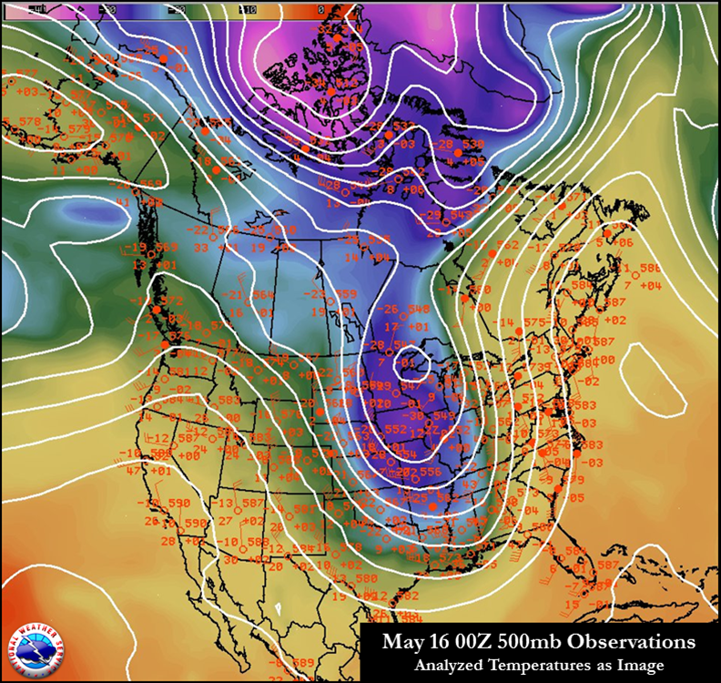
Here is a look at the anomalous weather system. On the weather balloon launches across North America on Thursday evening, the -30°C observed at 500mb (~18,000 ft) at NWS Davenport, IA was the third coldest in all of North America on the 00Z soundings (outside of two in far northern Canada). This speaks to just how deep the cold was, and enough so to briefly support a wet snow mixing in this morning.
Here is a water vapor image of the deep closed low over the area from early Friday morning.
Observations from Radar of Snow and Mixed Precipitation Progressing Closer to the Surface
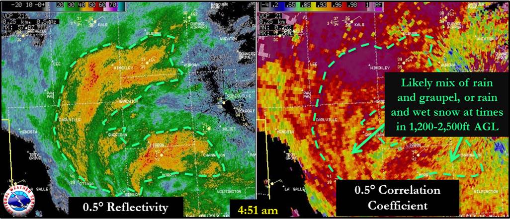
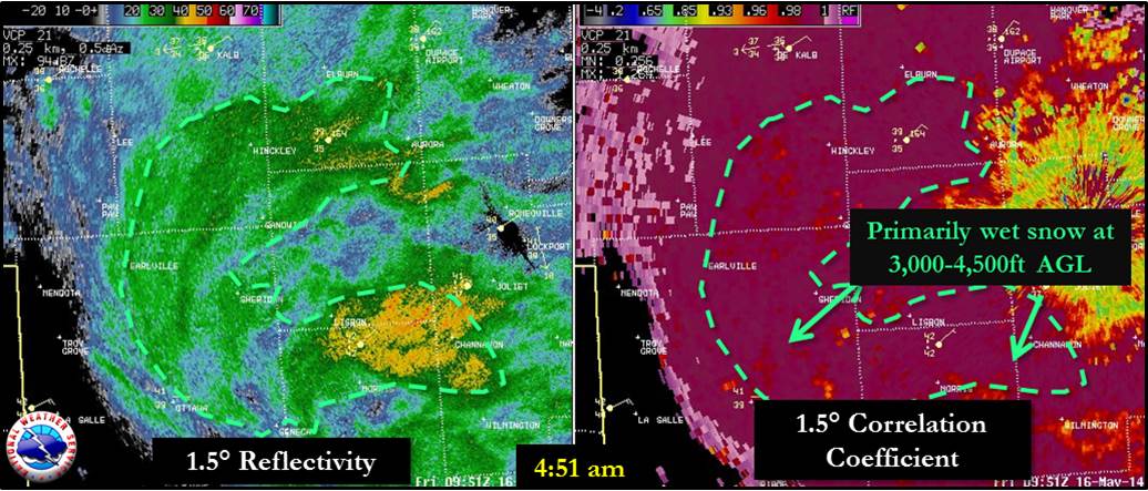
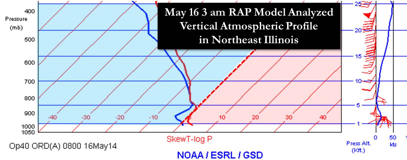
Below is a look at a model analysis of the vertical profile of the atmosphere over the west metro of Chicago at 3 am this morning. As the atmosphere saturated with approaching rain, it cooled, and this brought enough of the profile below zero close enough to the ground to enable snow to reach the surface.
Latest Observed Traces of Snowfall
Rockford: May 24, 1925
Chicago: June 2, 1910
PUBLIC INFORMATION STATEMENT
NATIONAL WEATHER SERVICE CHICAGO IL
603 PM CDT FRI MAY 16 2014 /703 PM EDT FRI MAY 16 2014/

...SECOND LATEST SNOWFALL ON RECORD OBSERVED IN ROCKFORD TODAY...

AT 706 AM CDT SNOW BEGAN OFFICIALLY FALLING AT THE GREATER
ROCKFORD AIRPORT AND IT CONTINUED TO SNOW...MIXED AT TIMES WITH
RAIN UNTIL 836 AM CDT. NO SNOW ACCUMULATED WHICH MAKES THE DAILY
SNOWFALL TOTAL FOR ROCKFORD FOR TODAY A TRACE. ONLY ONCE BEFORE IN
RECORDED WEATHER HISTORY FOR ROCKFORD HAS THERE BEEN A TRACE OF
SNOW ON OR AFTER THIS DATE IN MAY AND THAT WAS BACK ON MAY 24TH
1925 WHEN A TRACE OF SNOW WAS REPORTED.

$$

IZZI
This snowfall made it the longest snow season on record in Rockford. For more on this, see here.
For DeKalb, the 0.5" observed was the latest observed measurable snowfall on record. This breaks the record of May 11, 1966 (2.5").
Last Observed May Snowfall
Rockford: May 2, 2005*
Chicago: May 2, 2005 (prior to that, May 10, 1990)
* = Prior to May 16, 2014
:ID  LOCATION                  HIGH   LOW    PCPN
ORD: CHICAGO-O`HARE           :  46  /  37  /  0.10
CNII2: CHICAGO-NORTHERLY ISL  :  42  /  38  /
MDW: CHICAGO-MIDWAY           :  44  /  41  /  0.08
LOTI2: NWS CHICAGO-ROMEOVILLE :  43  /  38  /  0.23
RFD: ROCKFORD AIRPORT         :  51  /  35  /  0.18
DPA: DUPAGE AIRPORT           :  47  /  36  /  0.16
UGN: WAUKEGAN AIRPORT         :  44  /  33  /  0.02
ARR: AURORA/SUGAR GROVE       :  50  /  37  /  0.24
PWK: WHEELING/CHI EXEC        :  47  /  35  /  0.15
VPZ: VALPARAISO IN            :  43  /  35  /  0.03
:
UNOFFICIAL SUPPLEMENTAL AWOS LOCATIONS
:
DKB: DEKALB                 :  45  /  32  /
JOT: JOLIET                 :  43  /  39  /
IKK: KANKAKEE               :  45  /  41  /
IGQ: LANSING                :  42  /  39  /
C09: MORRIS                 :  46  /  41  /
VYS: PERU                   :  48  /  38  /
PNT: PONTIAC                :  46  /  45  /
RZL: RENSSELAER IN          :  48  /  41  /
RPJ: ROCHELLE               :  49  /  32  /
Chicago's Cold High Temperature on May 16th
PUBLIC INFORMATION STATEMENT
NATIONAL WEATHER SERVICE CHICAGO IL
411 AM CDT SAT MAY 17 2014 /511 AM EDT SAT MAY 17 2014/

...HIGH TEMPERATURE IN CHICAGO ON FRIDAY WAS NEAR RECORD
TERRITORY...

THE HIGH OF 46 DEGREES OBSERVED AT CHICAGO OHARE INTERNATIONAL
AIRPORT ON FRIDAY MAY 16TH WAS ACTUALLY NOT A RECORD LOW MAXIMUM
FOR THE DAY. THAT RECORD OF 44 SET IN 1891 JUST BARELY WAS
PRESERVED. HOWEVER...THIS WAS IMPRESSIVE COLD FOR MAY...ESPECIALLY
WITH IT BEING THE LATTER HALF OF THE MONTH.

THE 46 DEGREES WAS THE COLDEST MAY HIGH TEMPERATURE IN CHICAGO
SINCE 46 ON MAY 15TH 2011.

WHEN LOOKING AT HIGH TEMPERATURES OBSERVED AFTER THE MID POINT OF
MAY (MAY 16TH AND AFTER)...THIS WAS THE COLDEST IN CHICAGO SINCE 45
ON MAY 17 2002.

MAYBE THE MOST STRIKING FACT WAS THIS WAS ONLY THE FIFTH TIME SINCE
1930 WITH A HIGH TEMPERATURE THIS COLD AFTER THE MIDPOINT OF MAY!


COLDEST HIGH TEMPERATURES IN CHICAGO AFTER THE MIDPOINT OF MAY
(MAY 16TH AND AFTER) SINCE 1930:

TEMPERATURE        DATE
--------------------------
  46           MAY 16 1945
  46           MAY 17 1945
  46           MAY 24 1992
  45           MAY 17 2002
  46           MAY 16 2014

PRIOR TO 1930...THERE WERE 25 LATE MAY INSTANCES OF HIGHS THIS COLD
IN CHICAGO...WHICH VERY LIKELY HAD TO DO WITH THE OFFICIAL OBSERVING
LOCATION AT CHICAGO THEN BEING MUCH CLOSER TO LAKE MICHIGAN.
FOR MORE ON THE OFFICIAL OBSERVING LOCATION HISTORY IN CHICAGO SEE HERE.
$$

MTF

