Fast Facts | Snowfall Map | Science | Snowfall Reports | Photos
Total snowfalls were:
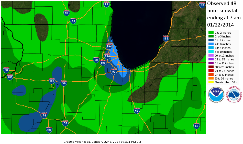
This map of snowfall accumulations for the 2-day period ending 7am on 22 January 2014 does not reflect the much higher but very localized reports of 20-24" around Griffith, Indiana. This map is derived from official NWS reporting stations as well as reports from trained observers using standardized equipment and measuring techniques in the CoCoRaHS network. These values are representative of general amounts over a wide area, but do not capture the highly localized nature of lake effect snow bands.
A strong Arctic cold front surged through northern Illinois and northwest Indiana on the afternoon of Monday January 20th. Air temperatures fell from the upper 20s to mid 30s as of late afternoon to the teens and lower 20s during the evening. At the same time, an upper level disturbance and surface trough began producing persistent light accumulating snow over the entire area mainly during the evening hours.
The 6pm radiosonde sounding out of Green Bay, WI sampled extremely cold temperatures at 850 mb (about 4,500 ft above the surface), of -22C (-7F). This airmass pouring down across the Lake Michigan waters of about 33-35F, set up an impressive thermodynamic environment that was very favorable for the formation of intense lake effect snow showers. As the inverted surface trough dropped southward during the mid and late evening, Arctic high pressure of nearly 1040 mb slowly built southeast from the northern Plains. Furthermore, a weak thermally induced low pressure formed over northern lower Michigan. The pressure gradient between these 3 features set-up a full northerly fetch of bitterly cold Arctic air down the length of Lake Michigan, with initial orientation of convergent flow into far northeastern Illinois. In addition, the upper level trough provided enhanced uplift through the favored snow growth zone of -12 to -18 degrees C.
A single band of heavy lake effect snow first impacted southeastern Lake County (IL) and northern Cook counties most significantly late Monday evening into the early overnight with snowfall rates of 1 to 2 inches per hour. As the wind convergence become more northerly, the band then sunk south along the Cook County shore, with impacts felt as far inland as central Kankakee County. By early Tuesday around 5 to 6am, north-northwest winds along the Illinois shore and east-northeast winds into Porter County Indiana, dramatically increased convergence into extreme northwestern Lake County Indiana. The development of at least one mesoscale low pressure area (mesolow) over the southern tip of the lake maintained this convergence for a much longer period of time over Lake County Indiana. The result was an intense single band of lake effect snow that produced 1 to 4 inch per hour snowfall rates and extreme snowfall amounts of 1.5 to 2 feet by early afternoon in the vicinity of Griffth, Hammond, East Chicago and Gary Indiana. During the most intense snowfall rates, whiteout conditions were common and major interstates such as 80/94 and I-65 became clogged with snow, bringing traffic to a standstill.
Despite the persistence of at least one mesolow through the mid afternoon and early evening, winds shifting to westerly across much of northwest Indiana, as well as less favorable thermodynamic conditions for lake effect snow resulted in the weakening of the band as it shifted east into Porter County.
|
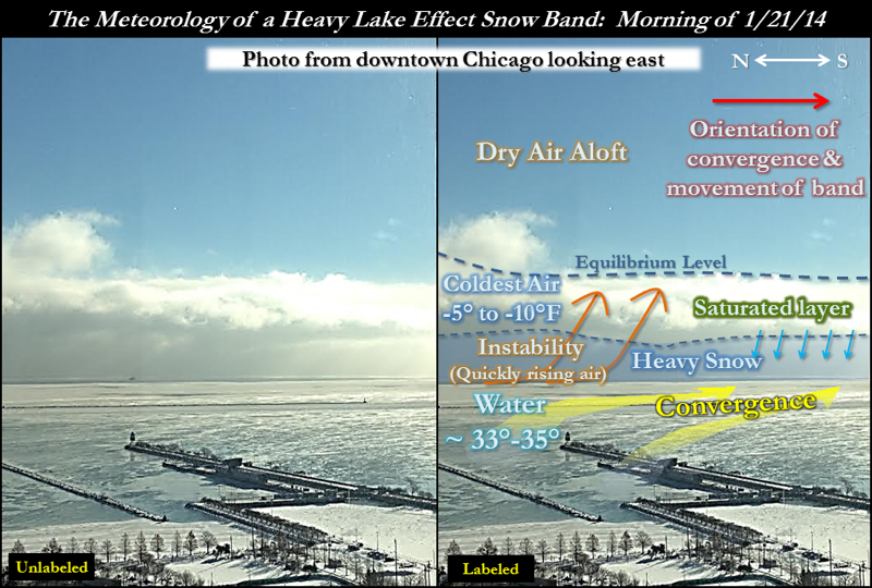
Meteorology of the Heavy Lake Effect Snow Band on 1/21/14 (click to enlarge) |
 |
|
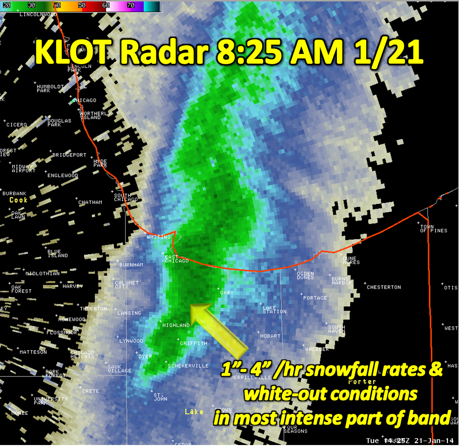
Radar Image of Intense Lake Effect Band at 8:25 am 1/21/14 (click to enlarge) |
 |
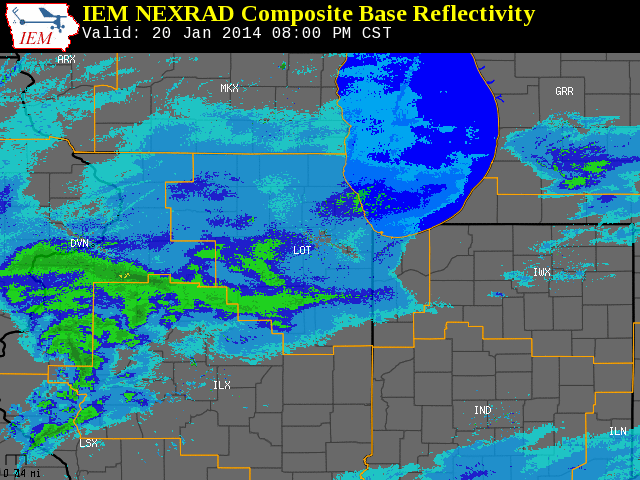
Radar 24-hour animation from 21 January 2014 showing evolution of lake effect snow band from Cook County into northwest Indiana, and persistence of this band for several hours (nearly 6 AM to 6 PM) over Lake County, Indiana.
PUBLIC INFORMATION STATEMENT
NATIONAL WEATHER SERVICE CHICAGO IL
1051 PM CST TUE JAN 21 2014


SNOW REPORTS FROM VOLUNTEER OBSERVERS AND NWS OBS SITES. WE THANK
EVERYONE FOR THEIR REPORTS DURING THIS EVENT!

LOCATION                   OBSERVED     TIME/DATE
                            VALUE     OF OBSERVATION    LAT    LON
ILLINOIS

...COOK COUNTY...
  PARK FOREST                  4.0 M   600 AM 01/21   41.48N  87.69W
  HARWOOD HEIGHTS              4.3 M   725 AM 01/21   41.97N  87.81W
  2 SW SKOKIE                  4.5 E   200 AM 01/21   42.02N  87.77W
  OHARE AIRPORT                5.9 M   558 AM 01/21   41.98N  87.90W
  3 SW MIDWAY AIRPORT          6.1 M   337 AM 01/21   41.75N  87.79W
  ROGERS PARK                  6.5 E   609 AM 01/21   42.01N  87.67W
  EVANSTON                     6.6 M   455 AM 01/21   42.05N  87.69W
  NORTHBROOK                   6.6 M   100 AM 01/21   42.13N  87.83W
  1 S CHICAGO                  6.9 E   548 AM 01/21   41.87N  87.63W
  NORTHBROOK                   6.9 M   700 AM 01/21   42.13N  87.83W
  3 SW MIDWAY AIRPORT          7.2 M   536 AM 01/21   41.75N  87.79W
  NORTHBROOK                  11.8 M   600 AM 01/21   42.13N  87.83W

...DUPAGE COUNTY...
  GLEN ELLYN                   3.0 M   200 AM 01/21   41.87N  88.06W

...LAKE COUNTY...
  HIGHLAND PARK                6.5 M   200 AM 01/21   42.18N  87.81W
  HIGHWOOD                     6.8 M   700 AM 01/21   42.21N  87.81W

...WILL COUNTY...
  LOCKPORT                     2.0 M  1230 AM 01/21   41.59N  88.05W
  ROMEOVILLE                   2.0 M   600 AM 01/21   41.65N  88.09W
  2 NW MOKENA                  3.0 E   200 AM 01/21   41.55N  87.90W
  MOKENA                       3.5 E   200 AM 01/21   41.53N  87.88W

LOCATION                   OBSERVED     TIME/DATE
                            VALUE     OF OBSERVATION    LAT    LON
INDIANA

...JASPER COUNTY...
  REMINGTON                    2.1 M   600 AM 01/21   40.76N  87.15W

...LAKE COUNTY...
  4 N CHESTERTON               1.7 M   530 PM 01/21   41.66N  87.06W
  5 SE MERRILLVILLE            1.8 M   600 PM 01/21   41.43N  87.24W
  CROWN POINT                  3.5 M   315 PM 01/21   41.42N  87.36W
  MERRILLVILLE                 4.0 E  1122 AM 01/21   41.47N  87.33W
  S HOBART                     5.0 M   545 PM 01/21   41.53N  87.27W
  SCHERERVILLE                 7.5 M   600 PM 01/21   41.49N  87.45W
  SCHERERVILLE                 9.5 M  1139 AM 01/21   41.49N  87.45W
  SCHERERVILLE                10.0 E  1136 AM 01/21   41.49N  87.45W
  HIGHLAND                    14.0 M  1245 PM 01/21   41.55N  87.46W
  HAMMOND                     16.0 M   155 PM 01/21   41.62N  87.49W
  3 SE EAST CHICAGO           20.0 E   700 PM 01/21   41.62N  87.41W
  GRIFFITH                    20.0 E  1129 AM 01/21   41.52N  87.42W
  GRIFFITH                    22.3 M   640 PM 01/21   41.52N  87.42W
  GRIFFITH                    24.0 U   130 PM 01/21   41.52N  87.42W
  N GRIFFITH                  24.0 E   230 PM 01/21   41.52N  87.42W
Photos
Facebook Photo Album

