|
|
|
Photo taken at shore of Waukegan, IL on October 31, 2014. Courtesy of John Edmondson |
Fast Facts | Photos | Meteorology | Winds | Lake Michigan | Storm Reports | Snowfall | Other Links
The highest wind gust over land was 69 mph at Gary Airport, while over nearshore waters was 67 mph at the Chicago Harrison-Dever Crib and Michigan City, IN.
The mid-lake south buoy, located about 43 miles east of Milwaukee, recorded a peak wind of 51 knots (59 mph). This was the 2nd highest speed recorded at the south buoy dating back to 1981, after only 54 knots (62 mph) on November 10, 1998.

|
Michigan City, IN |
Chicago Harrison-Dever Crib: |
|
|
|
|
Porter Beach in Porter, IN |
|
|
|
Courtesy of Greg Leeb |
|
Porter Beach in Porter, IN |
Evanston, IL High Wind Damage |
|
|
|
|
Courtesy of Larry Campbell |
Courtesy of Greg Leeb |
|
Winfield, IN |
Winfield, IN |
|
|
|
|
Courtesy of Pam Anderson |
Courtesy of Myra Gonzalez |
|
October 31st, 12 pm: Analyzed Surface Weather Map |
|
|
The average wind speed was 22.9 mph at Chicago O'Hare International Airport on October 31. This was the windiest day since February 21, 2014
PUBLIC INFORMATION STATEMENT
NATIONAL WEATHER SERVICE CHICAGO IL
956 AM CDT SAT NOV 1 2014 /1056 AM EDT SAT NOV 1 2014/

...HIGHEST WIND GUSTS FROM FRIDAY OCTOBER 31ST...

MARINE...

LOCATION                       SPEED     TIME/DATE
------------------------------------------------------
CHICAGO HARRISON-DEVER CRIB    67 MPH    0200 PM 10/31
3 WNW MICHIGAN CITY            67 MPH    1100 AM 10/31


LAND...

LOCATION                       SPEED     TIME/DATE
------------------------------------------------------
GARY                           69 MPH    0145 PM 10/31
1 NNW NAVY PIER                55 MPH    0229 PM 10/31
2 NE PALATINE                  55 MPH    1241 PM 10/31
SOUTH CHICAGO                  55 MPH    0500 PM 10/31
CHICAGO OHARE                  53 MPH    0413 PM 10/31
CHICAGO MIDWAY                 53 MPH    0122 PM 10/31
1 ENE ROCKDALE                 51 MPH    1212 PM 10/31
2 SSE STEWARD                  49 MPH    1256 PM 10/31
CHICAGO EXECUTIVE - PALWAUKEE  49 MPH    0102 PM 10/31
AURORA AIRPORT - SUGAR GROVE   49 MPH    0151 PM 10/31
DUPAGE AIRPORT                 49 MPH    1232 PM 10/31
LANSING                        48 MPH    0335 PM 10/31
2 E HARWOOD HEIGHTS            47 MPH    0125 PM 10/31
ROCKFORD AIRPORT               47 MPH    0959 AM 10/31
KANKAKEE AIRPORT               47 MPH    0335 PM 10/31
VALPARAISO                     45 MPH    0500 PM 10/31
WAUKEGAN                       45 MPH    1237 PM 10/31
PERU                           44 MPH    1215 PM 10/31
1 ESE BURNS HARBOR             43 MPH    1000 PM 10/31
2 ENE ELMWOOD PARK             43 MPH    0130 PM 10/31
PONTIAC                        43 MPH    0115 PM 10/31
DE KALB                        43 MPH    1235 PM 10/31
JOLIET                         43 MPH    0115 PM 10/31
LANSING                        42 MPH    0530 PM 10/31
ELMHURST                       42 MPH    0140 PM 10/31
FOREST PARK                    42 MPH    0227 PM 10/31
2 E NEW MILLFORD               41 MPH    0926 AM 10/31
ROCHELLE                       41 MPH    1015 AM 10/31
ROMEOVILLE                     41 MPH    1255 PM 10/31
RENSSELAER                     37 MPH    0335 PM 10/31

OBSERVATIONS ARE COLLECTED FROM A VARIETY OF SOURCES WITH VARYING
EQUIPMENT AND EXPOSURE. NOT ALL DATA LISTED ARE CONSIDERED OFFICIAL.
|
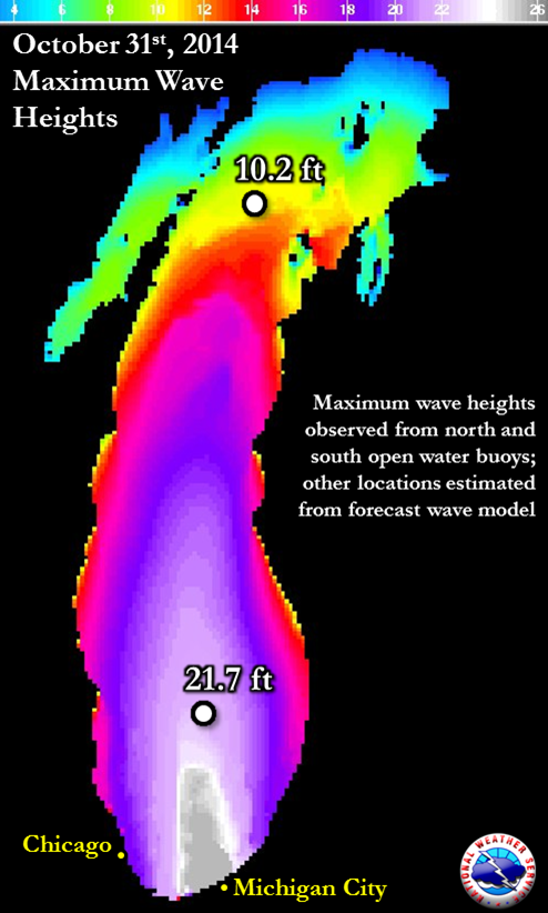
Highest Waves South Buoy Since 1981 |
||
|
Rank |
Storm Date |
Peak Wave |
|
1 |
9/30/2011 |
22.9 ft |
|
2 |
10/31/2014 |
21.7 ft |
|
|
10/30/2012 |
21.7 ft |
|
4 |
11/11/1998 |
20.3 ft |
|
5. |
10/20/2011 |
19.2 ft |
|
North Buoy Observations |
|
|
Winds and Air Pressure |
Wave Heights |
|
|
|
|
South Buoy Observations - Second Highest Observed Waves on Record |
|
|
Winds and Air Pressure |
Wave Heights |
|
|
|
|
Calumet Harbor Water Levels Note this is on the Calumet River and not truly Lake MI |
|
|
According to a long time Assistant Property Manager at the Indiana Dunes, the waves he saw during this event were the largest he could recall seeing. Below is his summary:
|
Sediment in Lake Michigan Visible from Satellite After the Event |
|
|
PRELIMINARY LOCAL STORM REPORT...SUMMARY
NATIONAL WEATHER SERVICE CHICAGO/ROMEOVILLE IL
112 PM CDT SAT NOV 01 2014

..TIME...   ...EVENT...      ...CITY LOCATION...     ...LAT.LON...
..DATE...   ....MAG....      ..COUNTY LOCATION..ST.. ...SOURCE....
            ..REMARKS..

1025 AM     NON-TSTM WND GST DUNE ACRES              41.64N 87.10W
10/31/2014  M51.00 MPH       PORTER             IN   TRAINED SPOTTER

            AT INDIANA DUNES STATE PARK.

1100 AM     NON-TSTM WND GST 5 N TOWN OF PINES       41.76N 86.97W
10/31/2014  M67.00 MPH       LMZ745             IN   C-MAN STATION

1245 PM     NON-TSTM WND GST GARY                    41.60N 87.34W
10/31/2014  M67.00 MPH       LAKE               IN   AWOS

            AT GARY/CHICAGO AIRPORT.

0110 PM     LAKESHORE FLOOD  CHICAGO                 41.88N 87.63W
10/31/2014                   COOK               IL   EMERGENCY MNGR

            WATER LAPPED ONTO LAKE SHORE DRIVE IN THE NORTH BOUND
            LANES...NORTH OF OAK STREET...FOR MOST OF THE AFTERNOON.
            DAMAGE OCCURRED TO THE BIKE PATH FROM BATTERING OF HIGH
            WAVES NEAR 47TH...OAK...AND SCHILLER STREETS.

0145 PM     NON-TSTM WND GST GARY                    41.60N 87.34W
10/31/2014  M69.00 MPH       LAKE               IN   AWOS

            AT GARY/CHICAGO AIRPORT.

0200 PM     NON-TSTM WND GST 4 NE CHICAGO            41.92N 87.57W
10/31/2014  M67.00 MPH       LMZ741             IL   C-MAN STATION

0254 PM     NON-TSTM WND DMG CHICAGO                 41.88N 87.63W
10/31/2014                   COOK               IL   FIRE DEPT/RESCUE

            150 FT BY 100 FT PIECE OF ROOFING FROM A 3 STORY BUILDING

            AT FOSTER AND BROADWAY BLOWN OFF. BUILDING WAS EVACUATED.

0350 PM     SLEET            CHICAGO                 41.88N 87.63W
10/31/2014  U0.00 INCH       COOK               IL   BROADCAST MEDIA

            SMALL SLEET PELLETS WITH SQUALLS AT NORTH AVENUE BEACH.
            REPORTED BY ABC 7.

0417 PM     NON-TSTM WND DMG EVANSTON                42.05N 87.69W
10/31/2014                   COOK               IL   TRAINED SPOTTER

            FOUR FT DIAMETER TREE DOWN ON SHERIDAN RD.
PUBLIC INFORMATION STATEMENT
NATIONAL WEATHER SERVICE CHICAGO IL
1017 AM CDT SAT NOV 01 2014

...MORNING SNOWFALL ROUNDUP...

   THE FOLLOWING ARE SNOW AMOUNTS FOR THE PREVIOUS 24-HOURS.
   OBSERVATIONS ARE USUALLY TAKEN AT 7 AM.

   24-HOUR SNOWFALL AMOUNTS FOR SATURDAY(11/01/14)...


NORTHERN ILLINOIS                              SNOW
  LOCATION (COUNTY):                           FALL(INCHES)

  PEOTONE (WILL)................................0.4
  MONEE (WILL)..................................0.3
  OAK PARK 2S (COOK)............................0.2
  PARK RIDGE (COOK).............................0.2
  OAK PARK 1NNE (COOK)..........................0.2
  LA GRANGE PARK 1SSW (COOK)....................0.2
  BEACH PARK 1W (LAKE)..........................0.2
  PEOTONE (WILL)................................0.2
  GLENVIEW 1SW (COOK)...........................0.1
  ROCKFORD 3NE (WINNEBAGO)......................0.1
  MIDWAY COOP (COOK)............................0.1

NORTHWEST INDIANA                              SNOW
  LOCATION (COUNTY):                           FALL(INCHES)

  WHEATFIELD 3S (JASPER)........................1.0
  MOUNT AYR 2NNE (NEWTON).......................0.6
  DE MOTTE 6S (JASPER)..........................0.5
And many places with a Trace of snow.


