Chicago, IL
Weather Forecast Office
A cold front, which was enhanced by a lake breeze, moved across northern Illinois during the late afternoon and early evening. This boundary was likely aided by a weak upper level disturbance to produce enough lift to lead to thunderstorm development. Although most of the activity that developed was rain showers void of thunder, one storm became severe quickly. Due to decent deep layer wind shear (change in wind speed and direction with height) this storm was able to develop into a supercell (A storm that is characterized by a rotating updraft). Supercell thunderstorms are known for their ability to produce severe weather, including large hail, damaging winds and even tornados. Although this storm did not produce a tornado, it did produce large hail from quarter to baseball size as it tracked across far southern McHenry and northern Kane counties shortly before 8 PM.
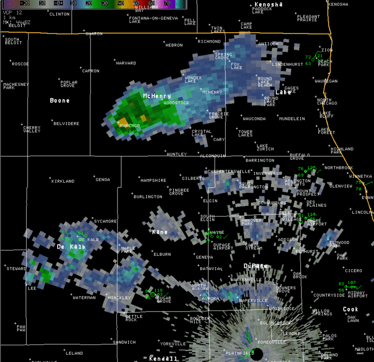
The animation shows reflectivity aloft, at just over 20,000 feet near the beginning of the loop, and at lower elevations as it nears the Radar. The pinks and purples indicate the hail suspended aloft. The light blue spike down radial from the thunderstorm is what is known as a "hail spike" and indicates the presence of large hail.
Hazards
Enhanced Hazardous Weather Outlook
Hazardous Weather Outlook
National Briefing
Storm Spotter Training and Seminars
Outlooks
Watch/Warning/Advisory Criteria
Snow Squall Warnings
Local Forecasts
Marine
Aviation
Fire
Text Products
Great Lakes Marine Portal
Lake Michigan Beach Forecast
El Nino
Snow and Ice Probabilities
US Dept of Commerce
National Oceanic and Atmospheric Administration
National Weather Service
Chicago, IL
250 George J Michas Dr.
Romeoville, IL 60446
815-834-1435 8am-8pm
Comments? Questions? Please Contact Us.

