Synopsis | Radar | Photos | Storm Reports | Other Recaps
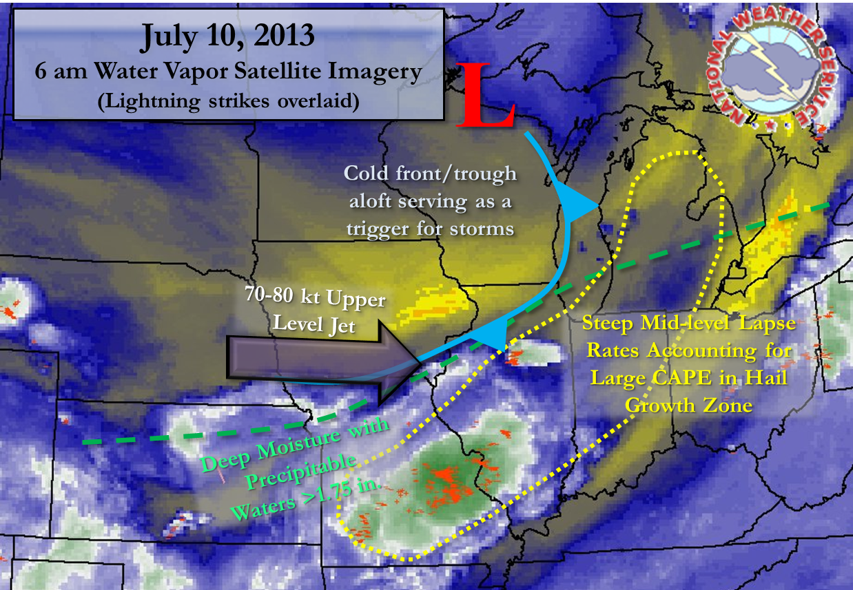
An extremely moist and unstable environment had been in place for a couple days across much of the Corn Belt and Great Lakes region. An upper trough with an associated cold front moved into this air mass on Wednesday morning over the local area and brought a reprieve from the humid air by late in the day. This trough was a trigger though for storm development in the early morning hours. The cold front itself may have acted to serve as a focus for the storms as well, especially for ongoing storm growth once initial storms had developed. Here is a look at the 6 am GOES water vapor imagery:
|
|
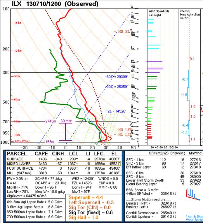
The morning weather balloon launch from NWS Lincoln, IL captured the pre-frontal air mass. There were several key ingredients indicated by the data. These were primarily coincident deep moisture and instability, owing to large convective available potential energy (CAPE). This is a parameter that basically indicates the ability air has to rise on its own and thus condense and form deep clouds. This instability in the presence of sufficient shear, which was around 35 kt (and likely 45 kt across the southern NWS Chicago CWA), owed to the potential for strong and sustained updrafts. These updrafts were even rotating above ~5,000 ft as indicated by the Doppler Radar as the storms evolved. The storms then by definition were supercellular, the most common type to produce large hail.
While the growth zone for large hail (-10°C to -30°C) was high above the ground on the sounding data below due to the warm air mass, the instability in this growth zone alone was very large, around 900 J/kg. This is well over research thresholds for large hail given the presence of strong storms. The instability was increased in this layer because of steep mid-level lapse rates which are common immediately ahead of a strong trough. This is indicated by the 7.1°C/km average from 500-850mb, and nearly 9.8°C/km from 550-650mb.
|
7 am NWS Lincoln, IL Weather Balloon Data |
|
|
Now while the atmosphere appeared prime for potentially large hail, it can often be a challenging to surmise if the large hail will make it down to the ground in these warm and especially very moist environments (as seen by the precipitable water at 2.08 in. on above sounding). It has been shown that suspended water can make hail melt quickly, especially smaller hail. So hail falling through a deep depth of rain in a storm cloud could cause enough melting for it to be non-severe hail, or even not hail at all, by the time it reached the ground. This is often the dilema for warning forecasters in these environments. At times when the updraft is significant enough and sufficiently large hail is formed aloft, and/or the hail is not falling back through the rain due to leaning storm structure, then the hail will make it down to the surface. It is likely because of the environment and radar behavior that in the case of Wednesday morning the largest hail (>1.5 in.) was confined to a very small area, possibly less than a square mile.
A couple final items of note on the above sounding for storm behavior and motion. The vectors on the right hand side of the sounding above are mainly unidirectional in the 1-6 km layer. This has been shown in case studies to lead to splitting supercell storms. What "splits" is the main updraft into two separate ones, which basically leads to two supercells that can have significantly different motions. In the bottom right of the graphic above is the calculated Bunkers storm motion. The storm motion vectors for right and left moving supercells are indcated. Note the sharp differences, with the right-moving being from the NW (323°) and the left-moving from the SW (248°).
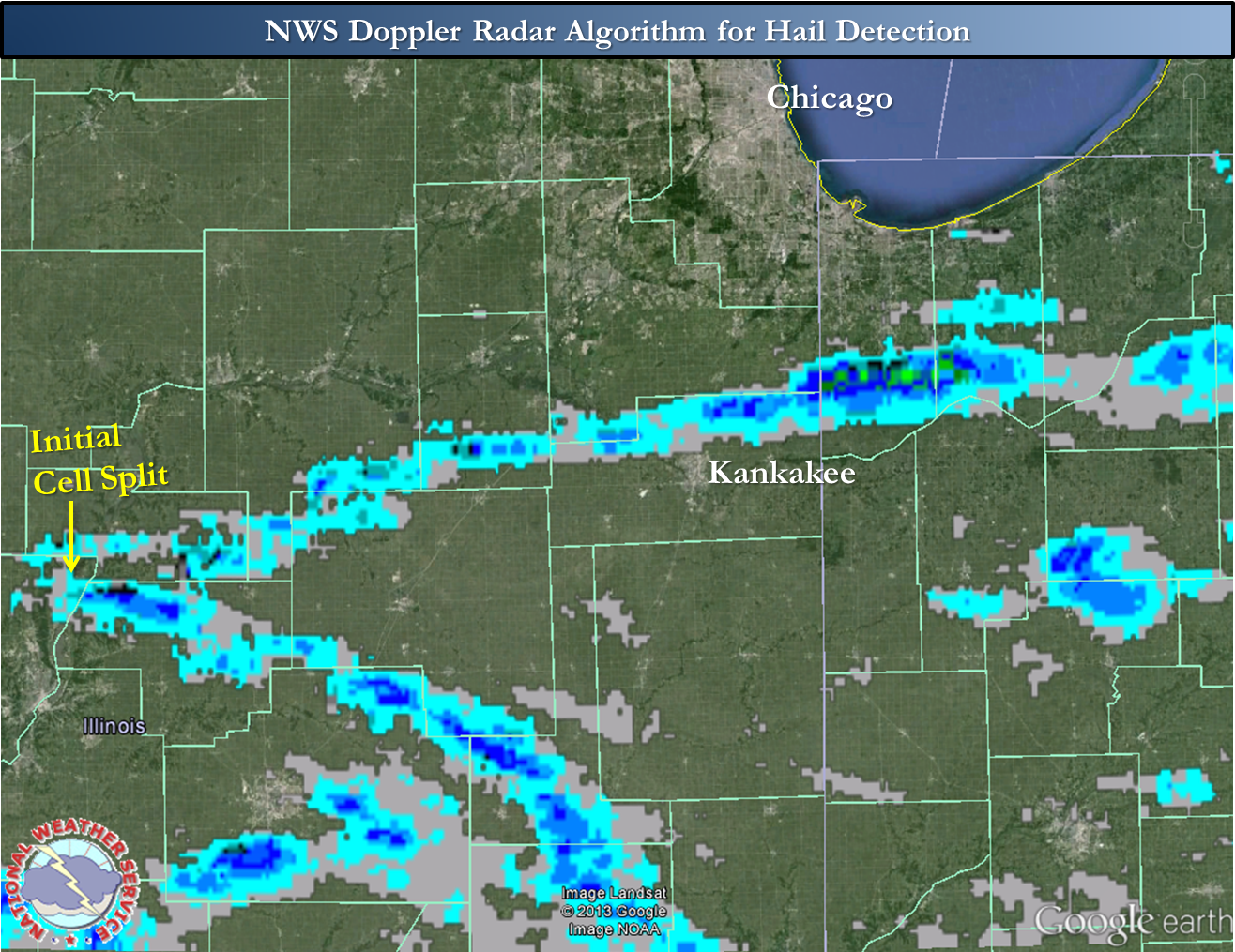
Indeed a cell split was observed early in this event, and both supercell storms would continue to evolve but on separate motions. Both supercells would spike up in intensity at times producing large hail. This can be seen in the below graphic. Left-moving supercells can weaken fairly quickly after a split, especially in the presence of curved wind vectors in the low-levels. This was not the case on the morning of the 10th, with the left-most cell, or at least evolution from it, persisting for over three hours.
|
NWS Doppler Radar Algorithm for Hail Detection |
|
|
|
NWS Doppler Radar has numerous algorithms, including one for large hail detection based on the radar reflectivity at certain temperature levels. These algorithms are not perfect by any means, but can help the situational awareness of NWS warning forecasters. Also, these can help to show longevity of hail potential. Much of the hail indicated by the algorithm in the above image is sub-severe, and the intensification where large hail was produced was often very brief and not always captured by the algorithm. |
|
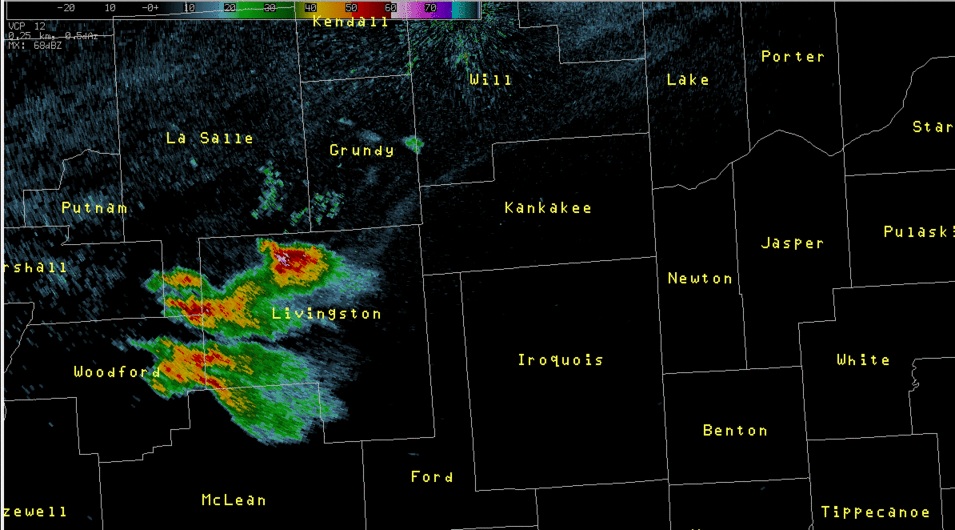
NWS Chicago 0.5° Reflectivity Radar Loop: 6:50 am - 10:15 am |
|
|
|
Click for high res loop (~ 8 MB) |
|
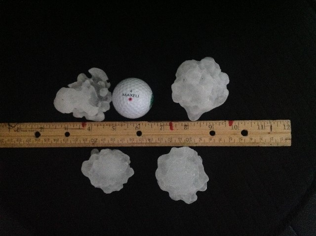
Large Hail from Essex, IL |
|
|
|
Thanks to Al Sheputis for this photo. |
|
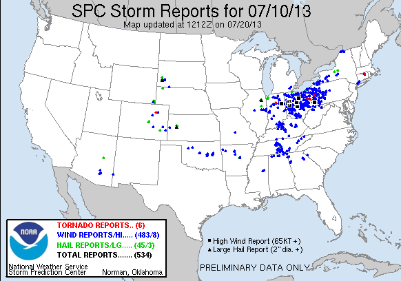
Nationwide Reports |
|
|
PRELIMINARY LOCAL STORM REPORT...SUMMARY
NATIONAL WEATHER SERVICE CHICAGO/ROMEOVILLE IL
738 PM CDT WED JUL 10 2013

..TIME...   ...EVENT...      ...CITY LOCATION...     ...LAT.LON...
..DATE...   ....MAG....      ..COUNTY LOCATION..ST.. ...SOURCE....
            ..REMARKS..

0807 AM     HAIL             GARDNER                 41.19N 88.31W
07/10/2013  E1.00 INCH       GRUNDY             IL   LAW ENFORCEMENT

            REPORTED NEAR INTERSTATE 55 AND GARDNER RD.

0811 AM     HAIL             4 SE SIBLEY             40.55N 88.32W
07/10/2013  E1.50 INCH       FORD               IL   PUBLIC

            DELAYED REPORT. HAIL MAINLY QUARTER SIZED WITH A FEW
            STONES TO PING PONG BALL SIZE. CAUSED SIGNIFICANT CROP
            DAMAGE AND ALSO DENTED CARS.

0814 AM     HAIL             SOUTH WILMINGTON        41.17N 88.28W
07/10/2013  E0.88 INCH       GRUNDY             IL   PUBLIC

0815 AM     HAIL             SOUTH WILMINGTON        41.17N 88.28W
07/10/2013  E1.00 INCH       GRUNDY             IL   PUBLIC

            DELAYED REPORT VIA FACEBOOK. HAIL LASTED ABOUT 5 MINUTES.
            HALF OF IT WAS QUARTER SIZED.

0815 AM     HAIL             ESSEX                   41.18N 88.19W
07/10/2013  M2.00 INCH       KANKAKEE           IL   PUBLIC

0945 AM     HEAVY RAIN       1 NW HEBRON             41.33N 87.22W
07/10/2013  M0.80 INCH       PORTER             IN   COCORAHS

            DELAYED REPORT. RAIN FELL IN 15 MINUTES.

0945 AM     HAIL             1 NW HEBRON             41.33N 87.22W
07/10/2013  M1.00 INCH       PORTER             IN   COCORAHS

            DELAYED REPORT. HAIL PICKED UP FROM GROUND AFTER STORM
            ENDED RANGED FROM 1/2 INCH TO QUARTER SIZED.

0948 AM     HAIL             5 E LOWELL              41.29N 87.32W
07/10/2013  E1.75 INCH       LAKE               IN   LAW ENFORCEMENT

            AT STATE POLICE DISTRICT 1 HEADQUARTERS.

0950 AM     HAIL             1 NE HEBRON             41.33N 87.19W
07/10/2013  E0.88 INCH       PORTER             IN   COCORAHS

0957 AM     HAIL             BOONE GROVE             41.35N 87.13W
07/10/2013  M1.50 INCH       PORTER             IN   PUBLIC

            DELAYED REPORT. HAIL RECOVERED ABOUT 10 MINUTES AFTER
            STORM PASSED BY...SO IT MAY HAVE BEEN AS LARGE AS GOLF
            BALL SIZED WHEN IT FELL.

1000 AM     HAIL             HEBRON                  41.32N 87.20W
07/10/2013  E0.75 INCH       PORTER             IN   PUBLIC

1009 AM     HAIL             2 WNW KOUTS             41.33N 87.06W
07/10/2013  E0.75 INCH       PORTER             IN   TRAINED SPOTTER


$$

RC

