Overview | Snowfall Amounts and Other Reports | Climate Facts | Wind Gusts | Other Links
For dual-pol images click here.
|
|
|
Click image to enlarge. For an unlabeled image, click here. |
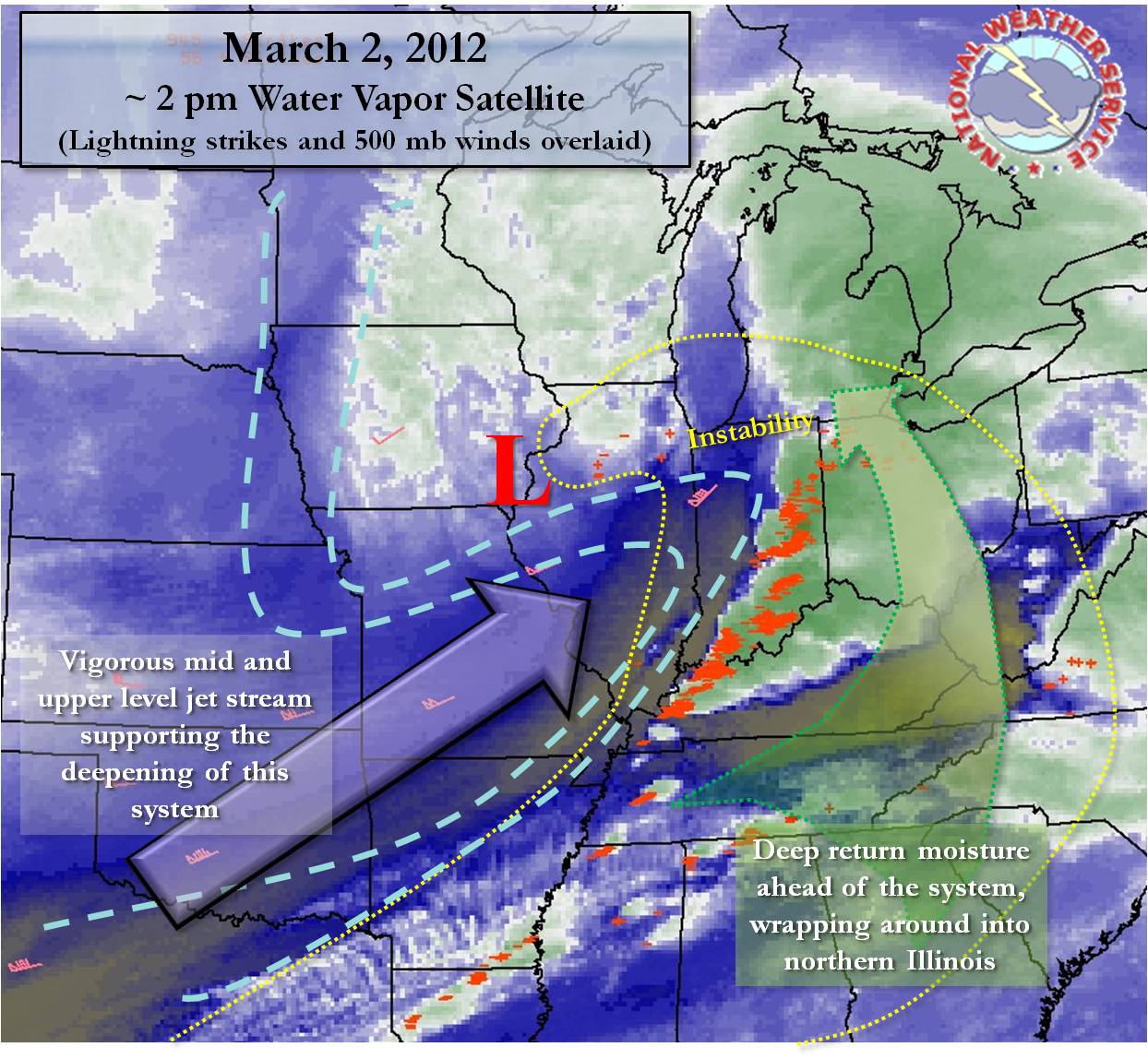
March 2nd saw a volatile early spring system impact the Great Lakes, Ohio River Valley, and deep South of the United States. This low pressure had winter-like weather on its north and west quadrants including over northern Illinois, Wisconsin, and Michigan, where rain changed to ice pellets and heavy snow, at times accompanied by thunder. On the system's eastern and southern flanks, a significant severe outbreak unfolded, with numerous apparent long-lived tornadoes. Throughout the entire region, gusty winds were seen as the entire system deepened rapidly.
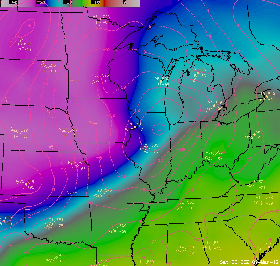
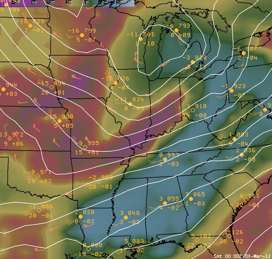
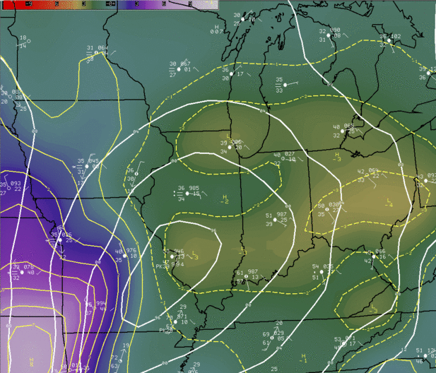
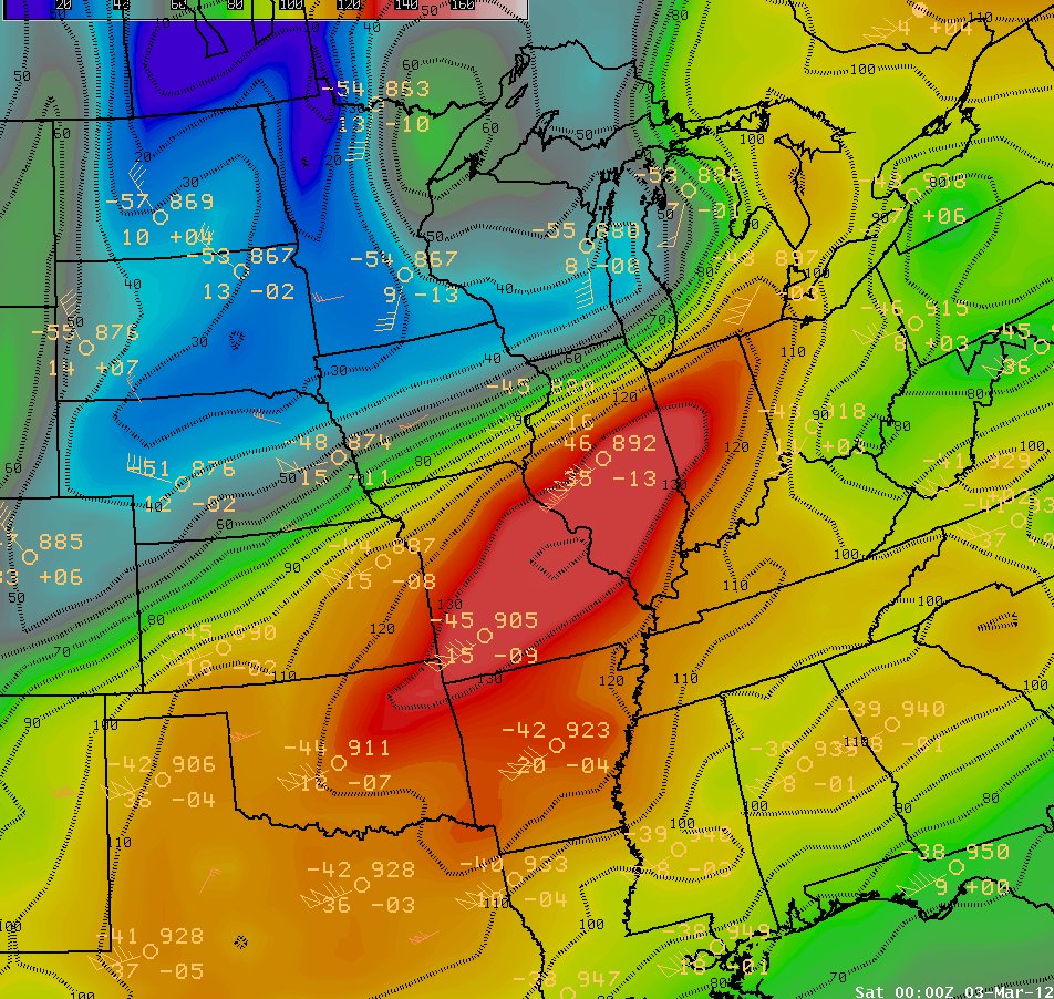
The below upper air maps show data plots from weather balloon instrument launches across the central U.S. at 6 pm on the 2nd. The maps have further been analyzed by a computer model to show key features, which are described under each image. Below these is a surface weather map from noon on the 2nd. The features depicted on these maps all came together in tandem to develop the widespread high impact weather event.
|
March 2nd, 6 pm Upper Air Graphics with RUC Model Analysis |
||
|
300 mb |
500 mb |
700 mb |
|
|
 |
 |
|
Wind speeds contoured. An impressive 135 kt jet was the key in deepening this system. Note the incredibly tight gradient in the isotachs within a favorable quadrant for lift over northern Illinois. This indicates the potential for significant vertical motion.
|
Temperatures contoured with height falls in the dashed lines. The strong cold advection in the mid-levels overriding the warm and moist boundary layer helped to ignite the severe weather to our southeast, and favor scattered thunder in our area. The height fall bulls eye, an impressive 160 meters in 12 hours, is centered directly over the area. Such magnitudes are often correlated with and are reflective of widespread, deep ascent.
|
Dew points are contoured, with heights plotted. The 700 mb low over central Lake Michigan had passed across far north central Illinois. Ample moisture in the mid-levels is shown to be wrapped ahead and around of this deepening system. The massive drying across southern IL into central IN, indicative of a system dry slot, further enhanced the instability and associated precipitation rates over northern IL. It also served as an impetus in triggering the convection to the southeast. |
|
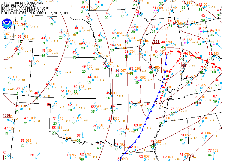
March 2, 12 pm Surface Weather Map |
|
|
|
This surface map reveals the massive temperature and moisture discontinuity developing around the system. Note the 71 degrees in southeast Illinois compared to 39 degrees in Chicago. The instability and moisture at the surface was lifted north over the warm front and helped to fuel scattered thunderstorms and heavy precipitation rates across northern Illinois. |
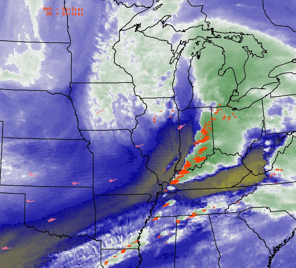
The rapid movement and development of the low pressure area helped to drive the winds. The pressure falls ahead of the low and rises behind it were substantial. This loop below is of analyzed three hour pressure tendency. Note the strong couplet of rises and falls and how they intensify over lower Michigan and northwest Ohio, where 50 mph + gusts were observed,
|
March 2nd: Three Hour Pressure Tendency Loop from Late Morning Through Evening |
 |
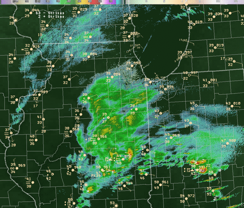
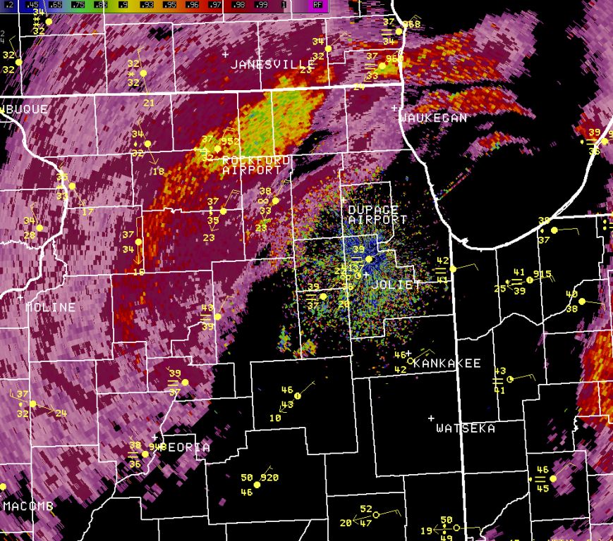
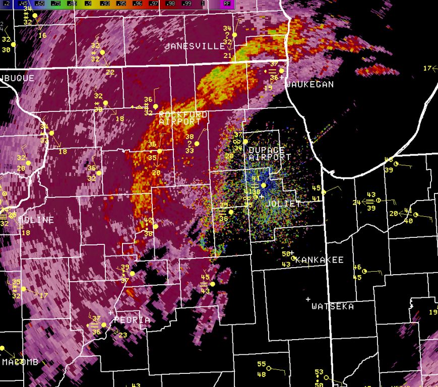
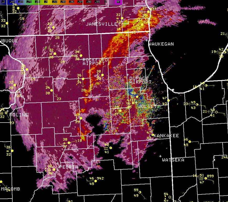
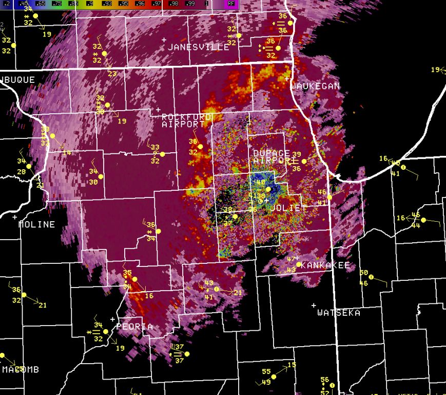
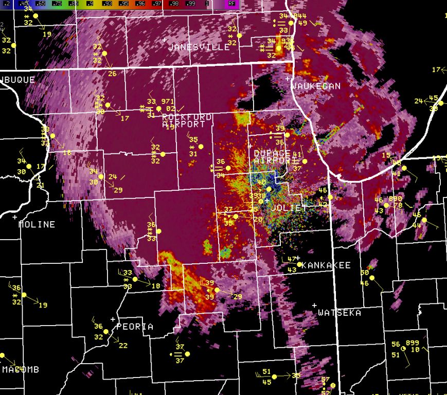
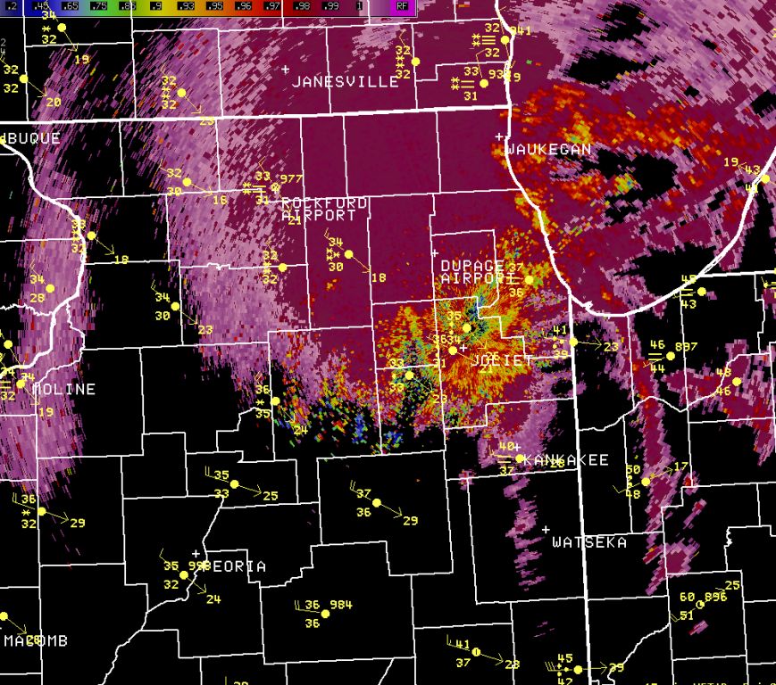
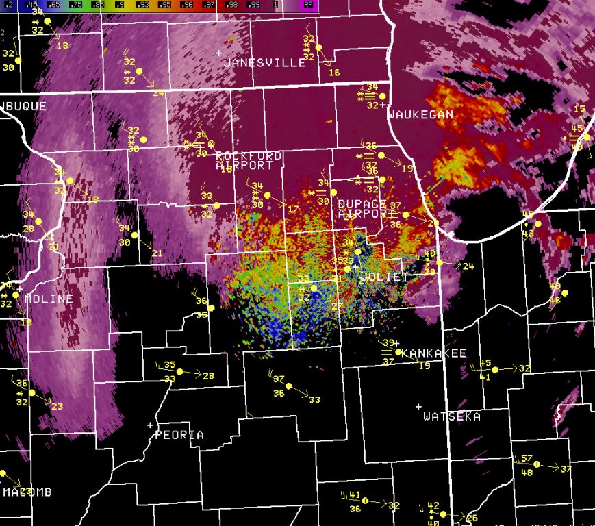
During the middle of the afternoon across parts of northern Illinois, moderate rain rapidly changed to heavy snow, including thundersnow. Numerous places saw a change to ice pellets first. The first radar loop below is of reflectivity, or basic energy reflected back to the radar. It is hourly through basically the entire event. Note the change in overlaid observations from rain to snow, at times with a mix. This correlates with higher reflectivity in some places.
|
March 2nd: Hourly Radar Loop from 10 am - 8 pm |
|
|
|
Click to open a loop (~4 MB) |
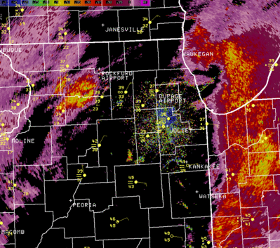
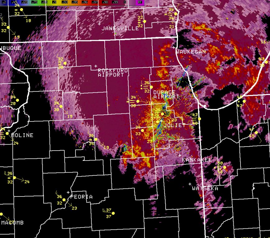
One of the exciting advantages of the dual-polarization (dual-pol) capability that NWS Chicago received in an October radar upgrade is better determination of precipitation type at the level where the radar is sampling. It is important to note where the radar is sampling as the radar beam height still increases at further distances from the radar due primarily to the curve of the earth. While the data may not necessarily be reflective of what is occurring at the ground at that point, especially at greater distances from the radar, it often can give a very good estimate.
One of the dual-pol elements that can help distinguish precipitation type and estimate the melting layer height is correlation coefficient. This variable describes the differences in shapes and types within the radar sample. Values of 0.98 to 1 indicate a homogenous area of scatterers, while lower values indicate a sample composed of varying sizes and types of scatterers (for example a mix of rain and snow, or rain and ice pellets, or different sized snowflakes). Within the correlation coefficient loop below, lower values of 0.85 to 0.95 are first seen across the Rockford area, and the airport reports a change to sleet. These lower values (green/yellow color) of correlation coefficient shift east through the loop. Soon after, most of the observations change to snow. The values after the change are greater than 0.98, depicting a homogenous composition where the radar is sampling. Knowing the state of the atmosphere behind this change, meteorologists could tell that this indicated all snow (at least at the radar level). From only the reflectivity loop above, one could likely not determine that. This shows the benefit to winter weather analysis and short term forecasting that dual-polarization data brings.
|
March 2nd: Dual-Polarization Correlation Coefficient Element Loop from 12 pm - 5 pm (every 5 minutes) |
|
|
|
Click to open a loop (~5 MB) |
Below you can view the still images of correlation coefficient from every half hour apart to further visualize the changes in the data and observations.
|
~1:00 pm |
~1:30 pm |
~2:00 pm |
~2:30 pm |
|
|
|
|
|
|
~3:00 pm |
~3:30 pm |
~4:00 pm |
~4:30 pm |
|
|
|
|
|
If interested in learning more on the dual-pol radar basics, please visit this public training page by the NWS Warning Decision Training Branch. For more detailed specifics behind the variables of dual-pol radar, please visit the NWS NSSL dual-pol information page here.
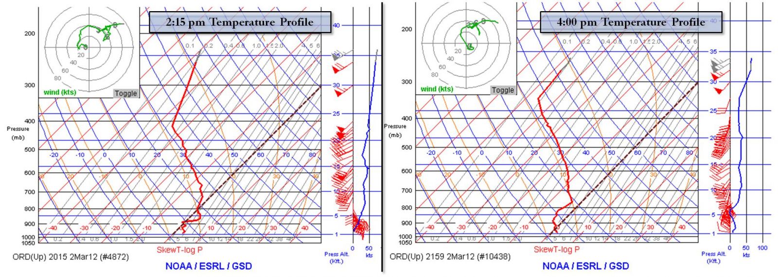
The rapid transition of precipitation type was due to cooling of the atmosphere, despite it being the middle of the afternoon. The cooling in part was simply due to cooler air wrapping into the northern and western parts of the system as the wind field begin to evolve counterclockwise around the low center. The widespread precipitation itself also helped to further cool the lower atmosphere. Intense precipitation, such as indicated within the observations and higher radar reflectivity echoes seen across northern Illinois, can often hasten the cooling process. Below are two mid-afternoon temperature and wind profiles from about two hours aprt near Chicago from aircraft equipped with weather sensors. Note the rapid change in the temperature profile within the lowest several hundred millibars. This was sufficient enough based on reports to change rain to more of a mix with ice pellets, and in some places further west to just snow. In the wind barb plots on the right side of each graphic one can see the winds became more northwesterly in the low-levels, aiding the temperature cooling.
|
March 2nd: Atmospheric Cooling near Chicago During the Afternoon |
|
|
Snowfall Amounts and Ice Pellet/Hail Reports
|
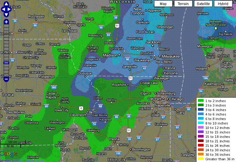
Snowfall Analysis |
|
|
|
Click to Enlarge |
|
NWS Cooperative Observer Reports |
|
|
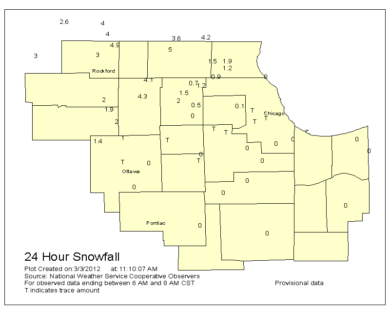
Snowfall Reports |
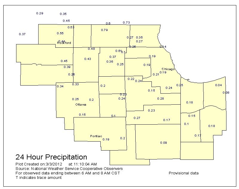
Precipitation Reports (Rain and Melted Snow) |
|
|
|
Snowfall Amounts of at Least One Inch from NWS Cooperative Observers and CoCoRaHS Observers:

Other Reports
PRELIMINARY LOCAL STORM REPORT...SUMMARY
NATIONAL WEATHER SERVICE CHICAGO/ROMEOVILLE IL
1247 AM CST SAT MAR 03 2012

..TIME...   ...EVENT...      ...CITY LOCATION...     ...LAT.LON...
..DATE...   ....MAG....      ..COUNTY LOCATION..ST.. ...SOURCE....
            ..REMARKS..

0145 PM     HAIL             AURORA                  41.77N 88.29W
03/02/2012  U0.25 INCH       KANE               IL   NWS EMPLOYEE

            RAIN MIXED WITH GRAUPEL REPORTED.

0201 PM     HAIL             HUNTLEY                 42.17N 88.42W
03/02/2012  M0.25 INCH       MCHENRY            IL   TRAINED SPOTTER

            PEA SIZED GRAUPEL MIXED WITH RAIN.

0205 PM     HAIL             JOLIET                  41.53N 88.12W
03/02/2012  E0.25 INCH       WILL               IL   PUBLIC

            PEA SIZED GRAUPEL MIXED WITH RAIN.

0215 PM     HAIL             WNW PARK RIDGE          42.01N 87.84W
03/02/2012  M0.25 INCH       COOK               IL   COCORAHS

            PEA SIZED GRAUPEL MIXED WITH RAIN.

0215 PM     HAIL             SCHAUMBURG              42.03N 88.08W
03/02/2012  M0.25 INCH       COOK               IL   AMATEUR RADIO

            PEA SIZED GRAUPEL MIXED WITH RAIN.

0225 PM     HAIL             PLAINFIELD              41.62N 88.20W
03/02/2012  M0.25 INCH       WILL               IL   TRAINED SPOTTER

            PEA SIZED GRAUPEL MIXED WITH RAIN BEGAN AT 225 CST AND
            ENDED AT 228 CST.

0228 PM     HAIL             WILMETTE                42.08N 87.73W
03/02/2012  E0.25 INCH       COOK               IL   TRAINED SPOTTER

0230 PM     HAIL             ESE WINNETKA            42.11N 87.74W
03/02/2012  M0.25 INCH       COOK               IL   COCORAHS

            PEA SIZED GRAUPEL MIXED WITH RAIN AND THUNDER.

0231 PM     HAIL             OTTAWA                  41.35N 88.84W
03/02/2012  E0.25 INCH       LA SALLE           IL   TRAINED SPOTTER

0234 PM     HAIL             AURORA                  41.77N 88.29W
03/02/2012  M0.25 INCH       KANE               IL   TRAINED SPOTTER

            PEA SIZED GRAUPEL MIXED WITH RAIN REPORTED AT THE AIR
            TRAFFIC CONTROL CENTER IN AURORA.

0235 PM     HAIL             2 SW LISLE              41.77N 88.12W
03/02/2012  M0.25 INCH       DUPAGE             IL   TRAINED SPOTTER

            GRAUPEL MIXED WITH RAIN.

0235 PM     HAIL             SW NAPERVILLE           41.76N 88.15W
03/02/2012  E0.25 INCH       DUPAGE             IL   TRAINED SPOTTER

            HAIL LASTED FROM 231 PM TO 232 PM.

0237 PM     HAIL             WARRENVILLE             41.82N 88.19W
03/02/2012  M0.25 INCH       DUPAGE             IL   TRAINED SPOTTER

            PEA SIZED GRAUPEL MIXED WITH RAIN.

0237 PM     HAIL             NAPERVILLE              41.76N 88.15W
03/02/2012  M0.25 INCH       DUPAGE             IL   NWS EMPLOYEE

            GRAUPEL MIXED WITH RAIN.

0237 PM     HAIL             MOUNT PROSPECT          42.07N 87.94W
03/02/2012  M0.25 INCH       COOK               IL   TRAINED SPOTTER

            PEA SIZED GRAUPEL MIXED WITH RAIN

0239 PM     HAIL             BATAVIA                 41.85N 88.30W
03/02/2012  M0.25 INCH       KANE               IL   TRAINED SPOTTER

            GRAUPEL MIXED WITH RAIN.

0250 PM     HEAVY SNOW       MENDOTA                 41.55N 89.12W
03/02/2012  U0.0 INCH        LA SALLE           IL   PUBLIC

            HEAVY THUNDERSNOW.

0250 PM     HAIL             OAK BROOK               41.84N 87.95W
03/02/2012  M0.25 INCH       DUPAGE             IL   CO-OP OBSERVER

            PEA SIZED HAIL REPORTED

0250 PM     HAIL             2 WNW BULL VALLEY       42.32N 88.39W
03/02/2012  M0.25 INCH       MCHENRY            IL   COCORAHS

            PEA SIZED GRAUPEL MIXED WITH RAIN FEEL AT 215 PM CST THEN
            TRANSITION TO SNOW BY 250 PM CST.

0303 PM     SNOW             ROCHELLE                41.92N 89.06W
03/02/2012  U0.0 INCH        OGLE               IL   PUBLIC

            THUNDERSNOW REPORTED IN ROCHELLE, AT NIU IN DE KALB,
            MARENGO, BELVIDERE, CORTLAND AND SYCAMORE. RELAYED BY
            BROADCAST MEDIA.

0303 PM     HAIL             DYER                    41.50N 87.51W
03/02/2012  M0.25 INCH       LAKE               IN   TRAINED SPOTTER

0305 PM     HAIL             LISLE                   41.79N 88.09W
03/02/2012  M0.25 INCH       DUPAGE             IL   TRAINED SPOTTER

            PEA SIZED GRAUPEL MIXED WITH RAIN.

0308 PM     HAIL             BOLINGBROOK             41.70N 88.08W
03/02/2012  E0.25 INCH       WILL               IL   PUBLIC

0308 PM     SNOW             ROSCOE                  42.42N 89.01W
03/02/2012  M1.0 INCH        WINNEBAGO          IL   PUBLIC

            SNOW TOTAL SO FAR. RELAYED BY WREX.

0315 PM     SNOW             SSW ASHTON              41.87N 89.22W
03/02/2012  M0.2 INCH        LEE                IL   COCORAHS

            SNOWFALL IN PAST 5 MINS. THE FLAKES ARE BIG AND THE
            SNOWFALL RATE SO HEAVY THAT VISIBILITY IS REDUCED TO FEW
            HUNDRED FEET. HEAVY SNOW CONTINUES.

0315 PM     HAIL             WARRENVILLE             41.82N 88.19W
03/02/2012  E0.25 INCH       DUPAGE             IL   TRAINED SPOTTER

            MODERATE TO HEAVY PEA SIZED GRAUPEL BEGINNING TO COVER
            PAVEMENT BEFORE MELTING. LASTED ABOUT TEN MINUTES.

0320 PM     SNOW             CRYSTAL LAKE            42.23N 88.33W
03/02/2012  U0.0 INCH        MCHENRY            IL   CO-OP OBSERVER

            THUNDER WAS BEING OBSERVED AS IT WAS SNOWING. FINE SNOW
            FLAKES ARE FALLING COMBINED WITH SLEET.

0325 PM     HAIL             NEW LENOX               41.52N 87.98W
03/02/2012  E0.25 INCH       WILL               IL   TRAINED SPOTTER

0332 PM     HAIL             PALOS PARK              41.66N 87.84W
03/02/2012  E0.25 INCH       COOK               IL   TRAINED SPOTTER

            SMALLER THAN PEA SIZED HAIL REPORTED. ABOUT 0.1 INCH OF
            HAIL ACCUMULATED CREATING EXTREMELY SLIPPERY CONDITIONS.

0341 PM     HAIL             SUMMIT                  41.78N 87.82W
03/02/2012  M0.25 INCH       COOK               IL   TRAINED SPOTTER

            PEA SIZED HAIL FALLING WITH HEAVY RAIN.

0345 PM     SNOW             1 N OTTAWA              41.36N 88.84W
03/02/2012  M0.9 INCH        LA SALLE           IL   COCORAHS

            3 PM STARTED SNOWING LIGHT AND SMALL FLAKES INCREASING IN
            INTENSITY SHORTLY THEREAFTER AND WITH LARGE FLAKES
            LASTING 45 MINUTES.

0345 PM     HAIL             HOMETOWN                41.73N 87.73W
03/02/2012  M0.25 INCH       COOK               IL   TRAINED SPOTTER

            SHORT PERIOD OF HEAVY RAIN AND PEA SIZED HAIL.

0350 PM     SNOW             DE KALB                 41.93N 88.75W
03/02/2012  M1.0 INCH        DEKALB             IL   TRAINED SPOTTER

            1 INCH OF SNOW ON THE GROUND. SNOWING AT AN ESTIMATED
            RATE OF 1 INCH PER HOUR.

0354 PM     HAIL             LAKES OF THE FOUR SEASO 41.41N 87.22W
03/02/2012  E0.25 INCH       PORTER             IN   TRAINED SPOTTER

            PEA SIZED GRAUPEL MIXED WITH RAIN.

0403 PM     SNOW             SOUTH BARRINGTON        42.09N 88.15W
03/02/2012  U0.0 INCH        COOK               IL   TRAINED SPOTTER

            SNOW STARTED AT 345 PM. HEAVY SNOW. GROUND ALMOST
            COVERED.

0412 PM     SNOW             FORRESTON               42.13N 89.58W
03/02/2012  M4.0 INCH        OGLE               IL   BROADCAST MEDIA

0412 PM     SNOW             GENOA                   42.10N 88.69W
03/02/2012  M2.0 INCH        DE KALB            IL   BROADCAST MEDIA

0415 PM     SNOW             SSW ASHTON              41.87N 89.22W
03/02/2012  M1.4 INCH        LEE                IL   COCORAHS

            SNOW FALL PAST 45 MINS. SLICK ROADS.

0415 PM     HAIL             5 WNW MARSEILLES        41.36N 88.78W
03/02/2012  E0.25 INCH       LA SALLE           IL   COCORAHS

            HAIL STARTED AT 1445 MIXED WITH RAIN, 1/4 TO 5/8 MIXED
            HAIL SIZE. HAIL ENDED AT 1500. HEAVY SNOW STARTED QUARTER
            SIZE FLAKES FOR 1 HOUR. STOPPED AT 4 PM.

0416 PM     SNOW             HUNTLEY                 42.17N 88.42W
03/02/2012  M3.0 INCH        MCHENRY            IL   TRAINED SPOTTER

            3 INCHES OF SNOW FELL SO FAR AT REED ROAD AND HALIGUS RD.


0418 PM     SNOW             E HARVARD               42.42N 88.62W
03/02/2012  M1.5 INCH        MCHENRY            IL   COCORAHS

            SNOWING QUITE HEAVY. 1 TO 1.5 INCHES ON GROUND.

0420 PM     SNOW             4 W HUNTLEY             42.17N 88.50W
03/02/2012  M2.0 INCH        MCHENRY            IL   COCORAHS

            2 INCHES OF SNOW FELL IN THE PAST HOUR. HEAVY SNOW IS
            STILL FALLING WITH LARGE SNOW FLAKES. THUNDER ACCOMPANIED
            THE SNOW WHEN THE SNOW INITIALLY BEGAN TO FALL.

0430 PM     SNOW             N HUNTLEY               42.17N 88.42W
03/02/2012  M1.7 INCH        MCHENRY            IL   COCORAHS

            1.7 INCHES OF SNOW FELL OVER THE PAST 75 MINUTES. 2
            INCHES OF SNOW ON THE GROUND. VERY HEAVY SNOW STILL
            FALLING.

0430 PM     SNOW             ROSELLE                 41.98N 88.08W
03/02/2012  M0.7 INCH        DUPAGE             IL   TRAINED SPOTTER

            0.7 INCHES OF SNOW FELL IN 20 MINUTES.

0445 PM     SNOW             ST. CHARLES             41.92N 88.30W
03/02/2012  M1.0 INCH        KANE               IL   CO-OP OBSERVER

            STILL SNOWING.

0510 PM     SNOW             4 NW ROCKFORD           42.31N 89.12W
03/02/2012  M2.5 INCH        WINNEBAGO          IL   CO-OP OBSERVER

            2.5 INCHES OF WET SNOW HAVE FALLEN THUS FAR.

0513 PM     SNOW             W ROCKFORD              42.27N 89.06W
03/02/2012  M2.8 INCH        WINNEBAGO          IL   BROADCAST MEDIA

            MEASURED AT WTVO. FAR WEST SIDE OF ROCKFORD.

0530 PM     SNOW             E HARVARD               42.42N 88.62W
03/02/2012  M3.4 INCH        MCHENRY            IL   COCORAHS

            3.4 INCHES OF SNOW HAVE FALLEN OVER THE PAST 2 HOURS.

0600 PM     SNOW             2 NE GURNEE             42.40N 87.91W
03/02/2012  M1.5 INCH        LAKE               IL   COCORAHS

            RAIN CHANGED TO SNOW AT 4 PM AND SNOWING PRETTY HEAVY
            SINCE THEN. WET AND HEAVY SNOW.

0730 PM     SNOW             2 WNW BULL VALLEY       42.32N 88.39W
03/02/2012  M4.9 INCH        MCHENRY            IL   COCORAHS

            STORM TOTAL SO FAR. LIGHT SNOW FALLING. 32F.

0730 PM     SNOW             ISLAND LAKE             42.28N 88.20W
03/02/2012  M1.0 INCH        LAKE               IL   TRAINED SPOTTER

            STORM TOTAL SO FAR.

0731 PM     SNOW             ELK GROVE VILLAGE       42.01N 87.99W
03/02/2012  E0.0 INCH        COOK               IL   TRAINED SPOTTER

            TRACE AMOUNT OF SNOW. HEAVY SNOW AT 4PM COVERED GRASSY
            SURFACES ROADS SLUSHY WITH WET SNOW SOME BLACK ICE IN
            OPEN AREAS ON ROADS. 7 PM SNOW STOPPED.

0744 PM     SNOW             CAPRON                  42.40N 88.74W
03/02/2012  M3.2 INCH        BOONE              IL   TRAINED SPOTTER

            STORM TOTAL SO FAR. SNOW SEEMS TO HAVE STOPPED FOR NOW.
            HEAVY SNOW ON TREES AND WIRES, SLIPPERY SIDE STREETS.

0934 PM     SNOW             POLO                    41.98N 89.58W
03/02/2012  M3.3 INCH        OGLE               IL   CO-OP OBSERVER

            3.3 INCHES OF SNOW FALL REPORTED FROM NWS CO-OP OBSERVER
            WITH A WATER EQUIV. OF 0.37 INCHES. REGULAR 9PM REPORT.

1200 AM     SNOW             ROCKFORD AIRPORT        42.20N 89.10W
03/03/2012  M2.9 INCH        WINNEBAGO          IL   OFFICIAL NWS OBS
|
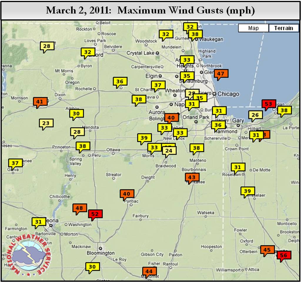
Maximum Wind Gusts at Automated Sensors |
|
|
|
Click to Enlarge |
PUBLIC INFORMATION STATEMENT
NATIONAL WEATHER SERVICE CHICAGO IL
457 AM CST SAT MAR 3 2012 /557 AM EST SAT MAR 3 2012/

...HIGHEST WIND GUSTS FROM MARCH 2ND-3RD STORM SYSTEM...

THE FOLLOWING IS A LIST OF MAXIMUM WIND GUSTS OF AT LEAST 35 MPH
FROM AUTOMATED SENSORS ACROSS THE AREA. OBSERVATIONS ARE COLLECTED
FROM A VARIETY OF SOURCES WITH VARYING EQUIPMENT...EXPOSURES...AND
REPORTING TIMES. NOT ALL DATA LISTED IS CONSIDERED OFFICIAL. THE
NATIONAL WEATHER SERVICE THANKS ITS PRIVATE AND PUBLIC PARTNERS
FOR PROVIDING US WITH THIS DATA.

...HIGHEST GUSTS OVER LAND IN THE AREA...

SITE................COUNTY...........GUST..
1 W CARBON HILL     GRUNDY           44 MPH
VALPARAISO          PORTER           44 MPH
2 W COLLEGEVILLE    JASPER           44 MPH
KANKAKEE            KANKAKEE         43 MPH


...GUSTS BY COUNTY...
......
...ILLINOIS...

...WILL COUNTY...

LOCKPORT (590 FT)(COOP)                 600 PM MAR 2     40 MPH
CHICAGO, IL (672 FT)(COOP)              555 PM MAR 2     40 MPH
PEOTONE (720 FT)(APRSWXNET)             620 PM MAR 2     38 MPH
CHANNAHON (505 FT)(COOP)                300 AM MAR 3     37 MPH
3 NNE WILMINGTON (488 FT)(RAWS)         605 PM MAR 2     37 MPH
JOLIET (COOP)                           300 AM MAR 3     35 MPH
4 ESE BEECHER (745 FT)(APRSWXNET)       336 AM MAR 3     35 MPH

...LIVINGSTON COUNTY...
PONTIAC (AWOS)                          535 PM MAR 2     40 MPH

...LEE COUNTY...

2 WNW DIXON (799 FT)(APRSWXNET)         125 AM MAR 3     36 MPH

...LA SALLE COUNTY...

PERU (620 FT)(AWOS)                    1035 PM MAR 2     38 MPH

...KANKAKEE COUNTY...

GREATER KANKAKEE AIRPORT (AWOS)         315 PM MAR 2     43 MPH

...KANE COUNTY...

AURORA MUNICIPAL AIRPORT (ASOS)         559 PM MAR 2     39 MPH
1 W BATAVIA (771 FT)(APRSWXNET)         632 PM MAR 2     36 MPH

...GRUNDY COUNTY...

1 W CARBON HILL (576 FT)(APRSWXNET)     522 PM MAR 2     44 MPH
MORRIS (479 FT)(AWOS)                   535 PM MAR 2     39 MPH

...DUPAGE COUNTY...

DUPAGE AIRPORT (754 FT)(ASOS)           549 PM MAR 2     37 MPH

...DE KALB COUNTY...

DE KALB (882 FT)(AWOS)                  555 PM MAR 2     36 MPH

...COOK COUNTY...

LAKEVIEW (620 FT)(APRSWXNET)            705 PM MAR 2     41 MPH
CHICAGO MIDWAY AIRPORT (618 FT)(ASOS)   150 AM MAR 3     39 MPH
2 WNW BURNHAM (574 FT)(HADS)            200 AM MAR 3     39 MPH
LANSING AIRPORT (AWOS)                  335 AM MAR 3     38 MPH
CHICAGO OHARE INTL APRT (658 FT)(ASOS)  715 PM MAR 2     37 MPH
CHICAGO EXECUTIVE AIRPORT (ASOS)        637 PM MAR 2     35 MPH

......
...INDIANA...

...PORTER COUNTY...

VALPARAISO (ASOS)                      1222 AM MAR 3     44 MPH

...NEWTON COUNTY...

5 NE MOROCCO (721 FT)(APRSWXNET)        112 PM MAR 2     35 MPH
4 WSW BROOK (659 FT)(APRSWXNET)         532 PM MAR 2     35 MPH

...LAKE COUNTY...

GARY REGIONAL AIRPORT (AWOS)            745 PM MAR 2     41 MPH
BROOKFIELD (APRSWXNET)                  208 AM MAR 3     35 MPH

...JASPER COUNTY...

2 W COLLEGEVILLE (657 FT)(INDOT)        753 PM MAR 2     44 MPH
2 WNW RENSSELAER (698 FT)(AWOS)         555 PM MAR 2     39 MPH

......
...OFFSHORE REPORTING STATIONS...

CHICAGO CRIB (577 FT)(MARITIME)         730 PM MAR 2     47 MPH
BURNS HARBOR (592 FT)(GLOS)             230 AM MAR 3     42 MPH

