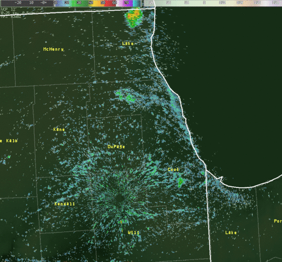
Within very hot and muggy air masses, there often is a large amount of atmospheric instability. Much of the time in higher end heat waves, this instability is bottled up, or "capped", not allowing deep updrafts to develop for thunderstorm formation. This was mainly the case on Thursday across the area. However, when there are such high surface temperatures and dew points, the atmospheric cap is often quite small and something subtle can trigger rapid thunderstorm growth. Such was also the case on Thursday. A weak upper level disturbance coming from central Minnesota very early Thursday morning moved over northeast Illinois during the afternoon's peak heating, with surface temperatures having already reached over 100°. This disturbance served as a "trigger" as meteorologists tend to call it. A focus was also present in the low-levels, with convergence along a lake breeze and along a weak frontal boundary across far southern Wisconsin. This trigger and focus amongst large instability was enough to develop isolated severe thunderstorms. A radar loop of the storms can be seen below.
|
KLOT Doppler Radar 0.5° Reflectivity Loop: ~ 2:30-4:45 pm |
|
|
|
Click to loop (~5 MB) |
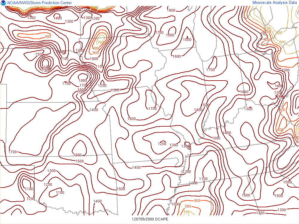
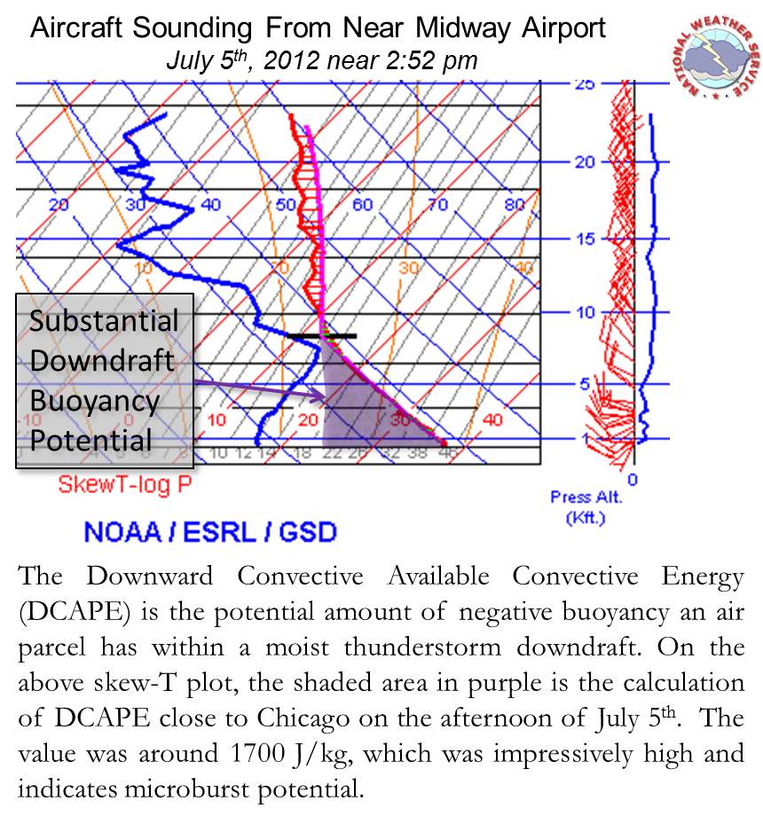
The thunderstorms brought isolated gusty winds, including a 94 mph measured gust at the Chicago Harrison-Dever Crib. These winds at times were seen many miles from the storm's heaviest rain cores in the form of outflows. This wind potential resulted from the high degree of surface heating and associated atmospheric instability. A value that can help meteorologists quantify the downward wind potential is DCAPE, which is shown and explained below.
Storm Damage in Northwest Indiana
Intense dowmbursts from the storms caused extensive damage in Gary, and Merrillville, IN. Damage occurred in Gary from near Ralston and 11th Avenue to near Clark and 17th Avenue. A garage at a church on 13th Avenue was destroyed. Part of the roof of a church at 4929 15th Avenue in Gary had a section of roofing peeled back. Many trees and limbs were damaged in the area.
Further south in Merrillville, at 57th Street and Hayes, large sections of the roofs of two apartment buildings were blown off. Roof debris damaged cars in the parking lot. Trees and large limbs were blown down in the area. A truck was overturned on I-65 near 61st Street. Trees, signs, and power lines were also blown down in the area. This damage is consistent with winds of 75 to 90 mph.
Summary of Storm Reports
PRELIMINARY LOCAL STORM REPORT...CORRECTED
NATIONAL WEATHER SERVICE CHICAGO/ROMEOVILLE IL
348 PM CDT FRI JUL 06 2012

..TIME...   ...EVENT...      ...CITY LOCATION...     ...LAT.LON...
..DATE...   ....MAG....      ..COUNTY LOCATION..ST.. ...SOURCE....
            ..REMARKS..

0315 PM     TSTM WND DMG     5 NNW CHICAGO           41.95N 87.67W
07/05/2012                   COOK               IL   NWS EMPLOYEE

            TREES DAMAGED BETWEEN BELMONT AND DIVERSY ALONG LAKE
            SHORE DRIVE...INCLUDING TWO LARGE TREES SNAPPED AT THE
            BASE AND ANOTHER LARGE TREE SPLIT.

0315 PM     MARINE TSTM WIND NAVY PIER               41.89N 87.62W
07/05/2012  E60.00 MPH       COOK               IL   TRAINED SPOTTER

            ROOF DAMAGE TO A BOAT DOCKED AT THE PIER.

0315 PM     MARINE TSTM WIND 4 NE CHICAGO            41.92N 87.57W
07/05/2012  M94.00 MPH       LMZ741             IL   C-MAN STATION

            MEASURED AT THE HARRISON-DEVER CRIB.

0354 PM     TSTM WND DMG     3 W GARY                41.60N 87.40W
07/05/2012                   LAKE               IN   DEPT OF HIGHWAYS

            THUNDERSTORM DOWNBURST WINDS CAUSED DAMAGE FROM RALSTON
            AND 11TH SOUTHEASTWARD TO NEAR CLARK AND 17TH. TREES AND
            LIMBS WERE BLOWN DOWN. A GARAGE WAS DETROYED. A CHURCH
            HAD A SECTION OF ITS ROOF TORN OFF AND A SHED DAMAGED.

0425 PM     TSTM WND DMG     MERRILLVILLE            41.47N 87.33W
07/05/2012                   LAKE               IN   LAW ENFORCEMENT

            SEVERAL TREES UPROOTED AND POWERLINES DOWN NEAR THE
            INTERSECTION OF 57TH AVE AND GRANT ST.

0425 PM     TSTM WND DMG     MERRILLVILLE            41.47N 87.33W
07/05/2012                   LAKE               IN   EMERGENCY MNGR

            LARGE SECTIONS OF ROOF BLOWN OFF TWO APARTMENT BUILDINGS
            AT 57TH AVE AND HAYES. ROOFING DEBRIS DAMAGED CARS IN THE
            PARKING LOT. TREES DAMAGED.

0427 PM     TSTM WND DMG     MERRILLVILLE            41.47N 87.33W
07/05/2012                   LAKE               IN   LAW ENFORCEMENT

            TRACTOR TRAILER BLOWN OVER ON I-65 JUST SOUTH OF 61ST
            AVE. HIGHWAY SIGN ON I-65 BLOWN DOWN.