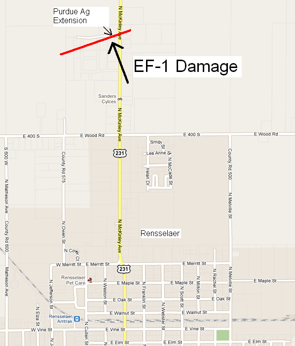
Rensselaer, IN
| Strength: | EF1 (86-110 MPH WINDS) |
| Path Length: | 1/4 MILE |
| Path Width: | 20-33 YARDS |
| Location: | 1 MILE NORTH OF RENSSELAER, IN |
| Time: | 4:37 PM (PRELIMINARY) |
The tornado touched down just north of Wood Road and south of West Amsler Road, and crossed U.S. Highway 231 (north McKinley Ave). The tornado was rated EF1 with roof damage to the Farm Bureau Insurance building (photos unavailable) at 2570 North McKinley Avenue as well as soffit, fascia and window damage to the Purdue Agricultural Extension office just to the west. The EF1 damage was confined to a path length of approximately 100 yards with weaker EF0 damage over the remainder of the track. The tornado lifted as it moved across highway 231. The maximum width of this tornado was 20 to 33 yards.
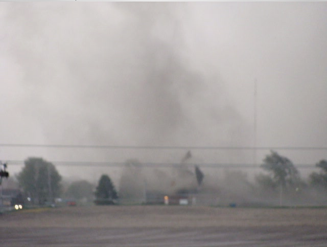
EF-1 Tornado and debris approaching Highway 231. Image courtesy of Joann Skinner.
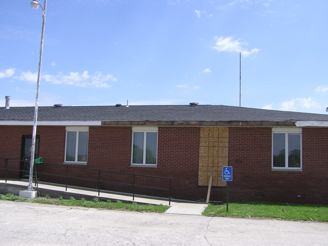
Damage to the west side of the Purdue Agricultural Extension Office.
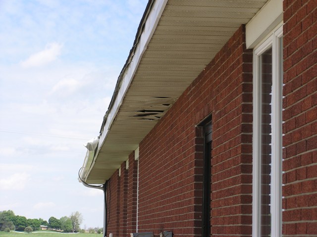
Soffit damage to the west side of the Purdue Agricultural Extension Office.
Debris strewn across a field just to the east of Highway 231 as the tornado dissipated.
Polo, IL
| Strength: | MAXIMUM RATING: EF1 (86-110 MPH WINDS) |
| Path Length: | 1 1/2 MILES |
| Path Width: | 200 YARDS |
| Location: | 1 MILE SOUTHEAST OF POLO, IL |
| Time: | 6:28 PM (ESTIMATED FROM RADAR) |
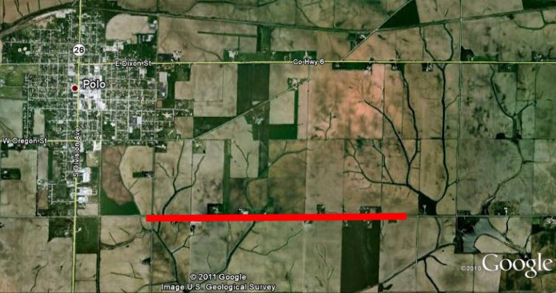
The tornado touched down just south of unincorporated Polo, just south of the intersection of Union Road and Judson Rd. A power pole on the east side of Union Road was blown, leaning over the road toward the west. At this point the tornado was rated low end EF1 with winds estimated at 85-90 mph.
The tornado widened slightly as it progressed to the east along Judson road, and uprooted a 20 inch diameter fir tree. At this point the tornado was still at EF1 strength, and there were branches down. The tornado then moved east and its width widened to its maximum 200 yards. There was roof damage to sheet metal roofing on 4 buildings and a wood outbuilding that was left leaning over by the tornado. In this area several 2X4’s were speared into the ground from different directions and insulation was plastered on the east and northeast face of buildings.
Another property just to the northeast of this point experienced six 16 inch diameter Norway Spruce trees snapped off, and a new wood power pole was snapped in half. It was here where the tornado reached its maximum intensity with winds at 100 mph. The tornado continued to the east maintaining its intensity (EF1 strength) another ¼ mile to the east where a grain bin was ripped off its foundation and a portion of the roof blown off to the north up against a fence. After this the winds weakened as the tornado lifted. A couple of additional grain bins were blown over, small branches snapped off, and shingles blown off roofs. Winds were estimated at 70-80 mph. The tornado lifted at 10506 Judson Road at Bailey Rd.
Along Judson Road southeast of Polo -- Small hardwood limbs snapped; large softwood tree uprooted (in background to the left, mostly cleaned up and removed). Debris was strewn a couple hundred yards to the east into the neighboring property.
Adeline Tornado and Winnebago County Tornadoes - Revised
ADELINE TORNADO
| Strength: | EF1 (90-110 MPH WINDS) |
| Path Length: | 29 MILES |
| Path Width: | 200 YARDS |
| Location: | 2 MILES EAST-SOUTHEAST OF FORRESTON TO MACHESNEY PARK, IL |
| Time: | 6:25 TO 6:54 PM CDT (ESTIMATED FROM RADAR) |
WINNEBAGO COUNTY TORNADO #1 - LATHAM PARK
| Strength: | EF1 |
| Path Length: | 2.7 MILES |
| Path Width: | 50 YARDS |
| Location: | BETWEEN LATHAM AND STEWARD ROADS EAST OF MERIDIAN ROAD |
| Time: | AROUND 6:55 PM CDT (ESTIMATED FROM RADAR) |
WINNEBAGO COUNTY TORNADO #2 - ROCKTON
| Strength: | EF1 |
| Path Length: | 1 MILE |
| Path Width: | 50 YARDS |
| Location: | BETWEEN 251 AND I-90 NORTH OF ROCKTON ROAD |
| Time: | AROUND 6:59 PM CDT (ESTIMATED FROM RADAR) |
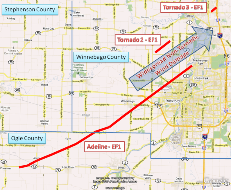
The first tornado touched down just east of Forreston, on Columbine Road near Illinois Route 72 in Ogle County. The tornado continued to the northeast with a near continuous path into Winnebago County, briefly lifting near Kelly Road east of just Alworth Road, then continuing again into the west side of Machesney Park past the Kennedy Middle School which had part of its roof blown off. This happens to be an incredibly long path for a non-supercell tornado, so this event will continue to be studied so that we may better understand exactly what was occurring that afternoon.
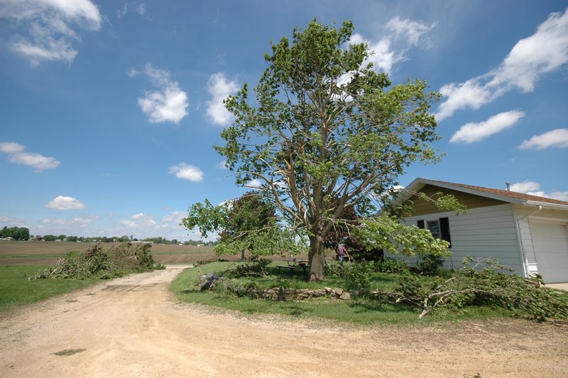
A persistent path of damage was observed until the end of the tornado’s life when damage became sporadic. Virtually no damage was observed outside of the tornado’s path. Several damage indicators indicating a persistent EF1 rating were observed throughout the tornado’s path. The path width was 200 yards at its maximum. There were numerous softwood trees snapped or uprooted, some up to 24-30 inches in diameter. A few hardwood trees up to 18 inches in diameter were also snapped. Many tree branches were also downed. Structural damage included several collapsed outbuildings, damaged siding and fascia to homes, and shingles blown off roofs. A mobile home lost part of its roof with walls partially collapsed in Adeline. Another double wide home lost a portion of its roof on Leaf River Road at Myrtle road. A couple of utility poles were also snapped or leaning over. Debris in numerous locations was deposited downstream from its origin, sometimes up to 400 yards. All of the damage suggested winds from 90-110 mph.
Widespread wind damage also occurred across Winnebago County, as described below. After additional surveys and discussions with eyewitnesses who reported funnel clouds and possible tornadoes, the more intense and concentrated pockets of damage originally attributed to straight-line winds have now been classified as tornadic. One of these tornadoes was spotted west of Latham Park. The third area of more concentrated damage occurred around the Roscoe Fire Station, where a large garage door was blown in. Note that the straight-line winds in this event were estimated at 90 to 100 mph, nearly equivalent in strength to these EF1 tornadoes.
Several large trees were snapped along Hwy 72 east of Forreston, IL, and were tossed and deposited in a convergent damage path.
Damage to trees and a manufactured home in Adeline, IL.
Tree, house, and outbuilding damage along Daisy Road.
Rockford, IL
| STRAIGHT LINE WIND DAMAGE | MAXIMUM WIND RATING: 90-100 MPH WINDS |
| Damage Width: | 5 MILES |
| Location: | WEST AND NORTHWEST ROCKFORD, ROSCOE, AND ADJACENT WINNEGAGO CO |
| Time: | 6:49 PM TO 7:09 PM CDT (PRELIMINARY) |
A fairly wide swath (up to 5 miles wide) of sporadic wind damage was observed across the west and northwest sides of Rockford and adjacent parts of rural Winnebago County. See map above. Preliminary survey results indicated all of this damage was due to straight line winds. However additional surveying supported the idea that some of the more intense damage likely was caused by tornadoes, as described above.
Debris all across this area were observed to have been blown from southwest to northeast. Other than to the fire station and middle school, no structural damage was observed except where trees fell on houses. Winds were estimated to have been 50 to 70 mph across the wide swath of damage area, with a few concentrated areas of winds as high as 90-100 mph, equivalent to EF1 strength.
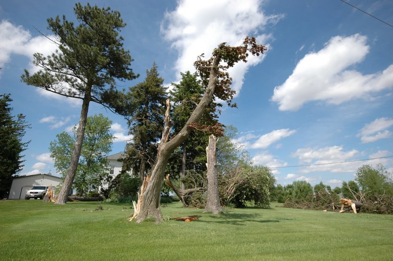
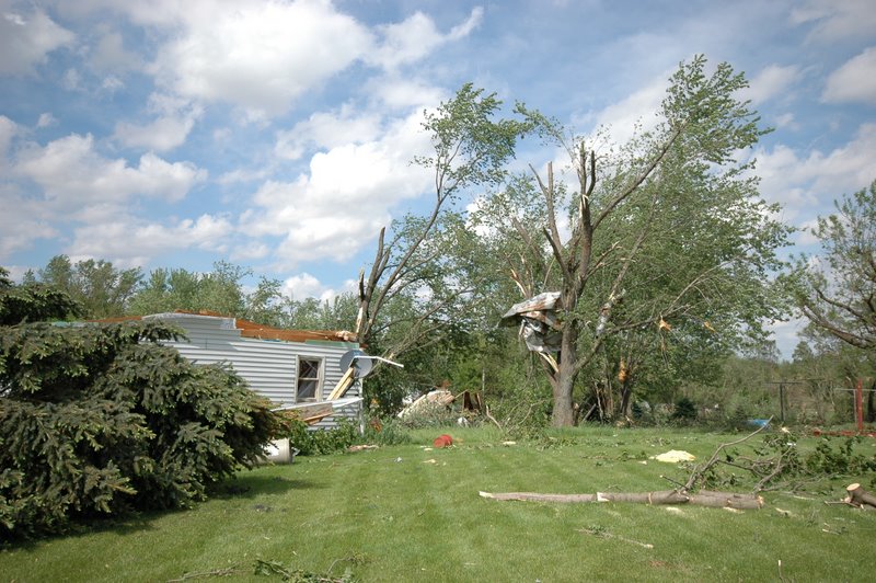
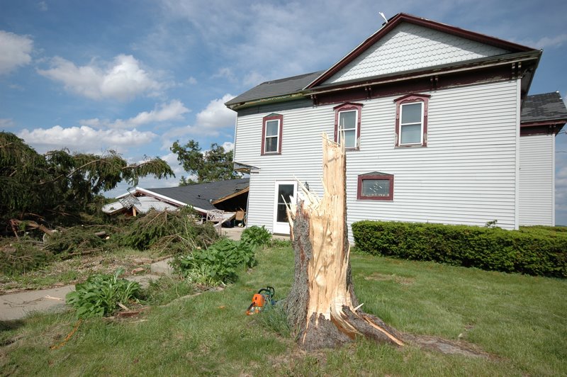
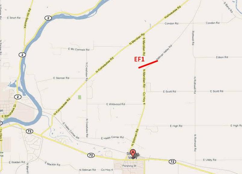
Stillman Valley, IL
| Strength: | MAXIMUM RATING EF1: 90-110 MPH< |
| Path Width: | 50 TO 100 YARDS |
| Path Length: | 1/2 MILE |
| Location: | 2.9 MILES NORTH OF STILLMAN VALLEY TO 3.1 MILES NNE OF STILLMAN VALLEY |
A brief tornado took out a dual wood truss electrical transmission line tower, tore off the gable and part of the roof of a house, peeled sofit and shingles from a couple other houses, and knocked down trees and limbs. Truck trailers were also overturned.

