An unseasonably warm and humid air mass was transported northward across northern Illinois and northwestern Indiana late Friday night into Saturday, as a warm front, associated with a strong storm system across northern Manitoba (Fig 1 and 2), moved across the Western Great Lakes region. This air mass dominated the region for much of Saturday; however, in the afternoon a cold front approached the region from the Northwest. (Fig. 3 and 4). This cold front became the focal point for thunderstorm development as it interacted with unseasonable warm and unstable atmosphere across the area.

Figure 1. Surface analysis at 4 PM on Friday June 3rd.

Figure 2. Surface analysis at 7 AM on Saturday June 4th.
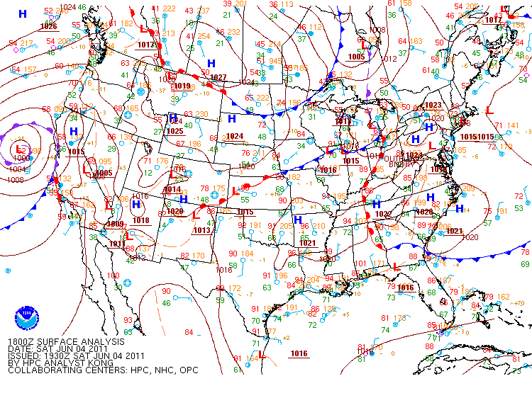
Figure 3. Surface analysis at 12 PM on Saturday June 4th.

Figure 4. Surface analysis at 4 PM on Saturday June 4th.
Temperatures to the south of the approaching cold front quickly warmed into the middle to upper 90s across portions of Illinois by early to mid afternoon (Fig. 5). Meanwhile, dew point temperatures climbed into the upper 60s to the low 70s, leading to a very warm and moist air mass. To the north of the front temperatures were slightly cooler, but more importantly, it was also much dryer. Figure 5 shows that although temperatures were still quite warm (e.g., mid to upper 80s), dew points across southern Wisconsin were in the 30s and low 40s. Therefore, this front marked the transition from a very warm and moist unstable atmosphere to a warm and dry stable atmosphere. Due to this interaction, a complex of thunderstorms quickly developed within this volatile atmosphere across northeastern Illinois.


Fig. 5 Surface fronts (blue) and pressure (green lines) overlaid with surface observations and regional radar at 10:00 AM, 1:00 PM, 4:00 PM and 7:00 PM on Saturday.
The series of figures below show the evolution of the severe thunderstorm complex as it moved across portions of the Chicago metro area and southeastward across northwestern Indiana. The time period covered is from 4:14 PM through 4:55 PM. Two figures are displayed for each time period below: radar reflectivity (left hand image) and the ground relative wind velocities (right hand image). The green colors represent winds blowing towards the radar, while the red colors are winds blowing away from the radar. The shades of green and red indicate the magnitude of the winds, with the brightest colors representative of the strongest winds. In the figures, the radar is the black circle in northern Will County to the west of the storms.
This complex of thunderstorms first developed as a cluster of discrete super cell thunderstorms across portions of southeastern De Kalb, Kane, DuPage and Cook counties prior to the 4 o’clock hour. However, as they moved eastward, the outflow (rain cooled air that moves out from under the thunderstorm) from the initial storms lead to the development of additional storms. This process continued until a solid line of storms developed. Shortly after 4 PM a line of severe thunderstorms extended from the Chicago near-shore waters southwestward to far southwestern Will County. Note the reflectivity (left hand) images at 414 and 427 PM show areas of weaker returns (green and blue colors) developing on the back side of the line. These are known as weak echo channels and are indicative of strong downdrafts in the storms that usually lead to very strong surface winds. The corresponding velocity (right hand) images show areas of brighter green and red colors developing across southern Cook and west central Lake County Indiana. The line of storms began to speed up over the next several minutes as strong winds pushed out ahead of the storms and lead to quick downstream development.


414 pm Radar reflectivity and Velocity


427 pm Radar reflectivity and Velocity


446 PM Radar reflectivity and Velocity


455 PM Radar reflectivity and Velocity
Although there were numerous reports of wind damage, especially across southern Cook County, the most intense wind damage occurred across southern Lake and northern Jasper counties in Indiana. Around 437 PM the radar continued to indicate quickly intensifying winds within the thunderstorm complex. Notice how the orange colors emerge in the velocity images at 446 and 455 PM. These colors indicate winds in excess of 80 mph. Damage was increased in intensity during these times from St John’s eastward across southern Crown Point and southward along interstate 65. However, once the storms got east of I-65, the damage became more intense still. The most intense damage occurred east of I-65 southeastward towards the Kankakee river and into far northern Jasper county. A storm survey was conducted across these areas and it was determined that the most intense damage corresponded to winds of 90 to 110 mph. The Figure below shows all of the wind and hail reports across the area.


