.png) |
Overview
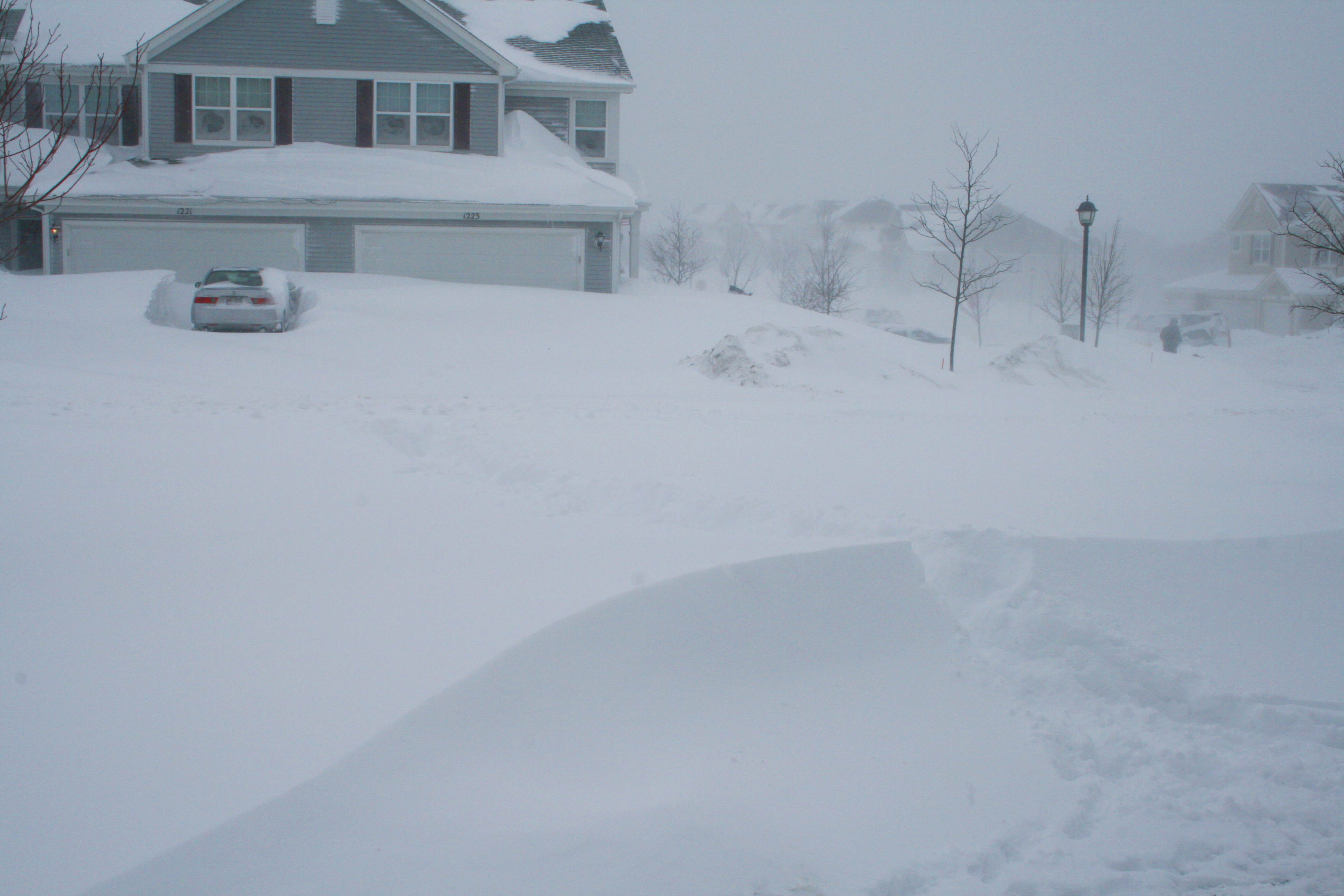
Northern Illinois and northwest Indiana were walloped by one of the most powerful winter storms in history between January 31 and February 2, 2011. An initial period of light accumulating snow occurred from the evening of January 31st into the morning of February 1st, including lake effect snowfall over northeastern Illinois. The most memorable period of the storm occurred from the afternoon of February 1st through the early morning of February 2nd, when a powerful area of low pressure tracked slowly north. During this time, the snowstorm was accompanied by fierce winds, gusting to 50 to 60 mph, and even higher at times. The intense winds and heavy snow reduced visibility to near zero at times and produced widespread snowdrifts of 2 to 5 feet, and a few drifts of 10 feet or more. The storm was powerful enough to generate vigorous updrafts, resulting in lightning, thunder, and small hail.
Over the three day period, snowfall totaled 21.2 inches officially at Chicago’s O’Hare Airport, making it the third largest snowstorm on record for the city of Chicago.
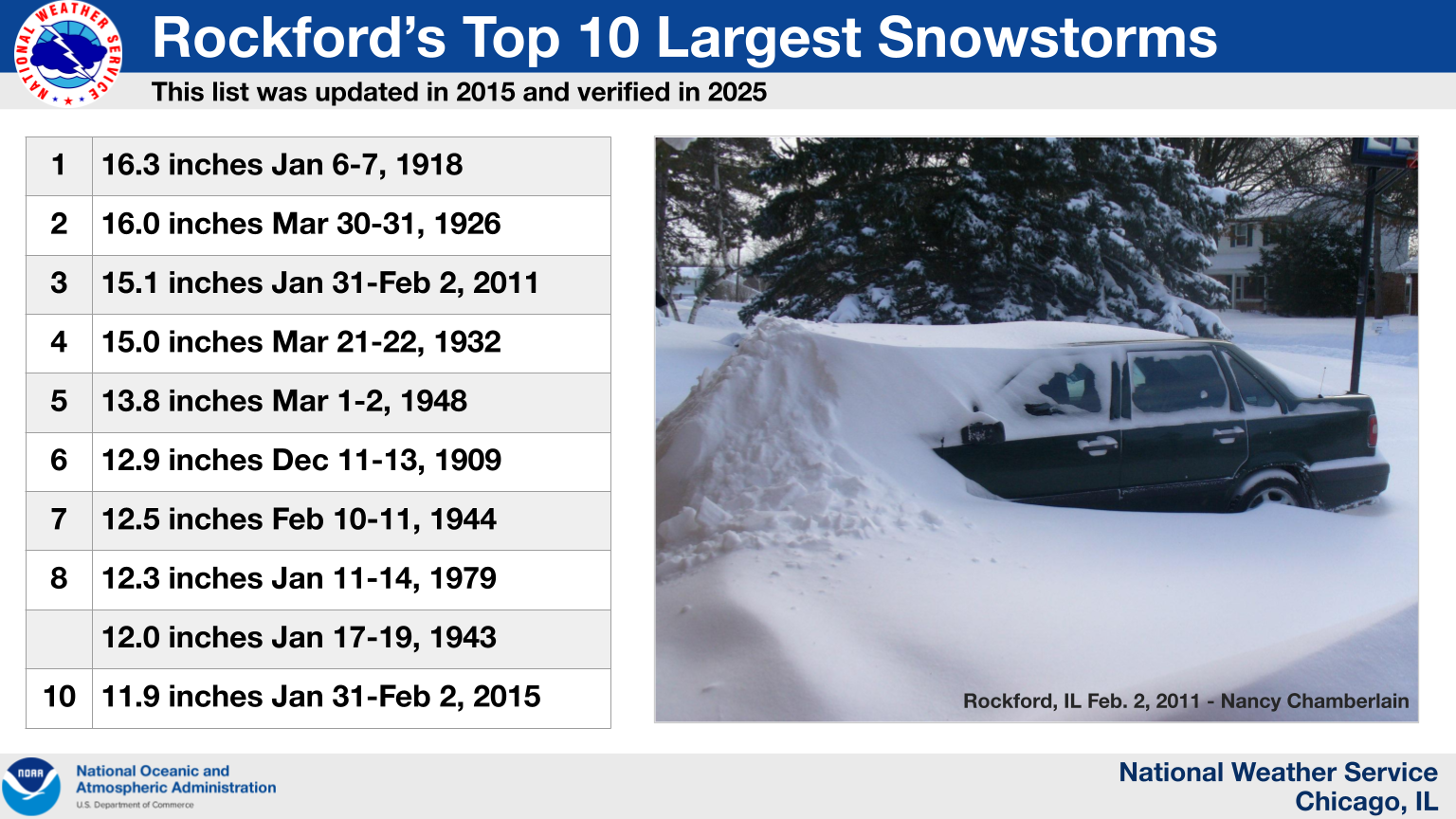
The official total at Rockford Airport was 15.1 inches, which is also third on the all-time list for Rockford.
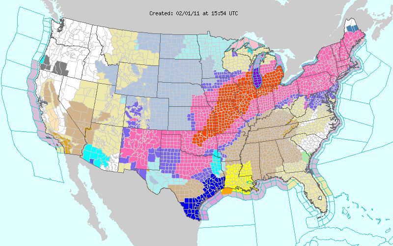 |
| NWS headlines in effect on the morning of February 1, 2011, with the large red footprint being Blizzard Warnings. |
Snow Totals
Snowfall totals from the initial round of light snow and lake effect snow ranged from roughly a half inch to upwards of 4" in some locations over far northern Illinois. Meanwhile heavy snow from the storm was spreading into central Illinois from the south during the late morning. By evening rush hour, snow had overspread much of northern Illinois and northwest Indiana. Snow diminished over most areas during the late night and early morning hours of February 2, but a band of lake effect snow continued over the Chicago metro area into mid morning, and swung across northwest Indiana during the early to mid afternoon. Snowfall totals were generally 6 to 12 inches south of a line from Gibson City to Rensselaer, but one to two feet over most of northern Illinois and northwest Indiana. The blowing and drifting made snowfall measurement very challenging, even for the most experienced weather observers. In addition, the convective nature of the snow resulted in some variability of the snowfall intensity. Lake effect and lake enhancement generally made snowfall totals highest in Lake, McHenry, Cook, and DuPage Counties in Illinois, as well as Lake and Porter Counties in northwest Indiana.
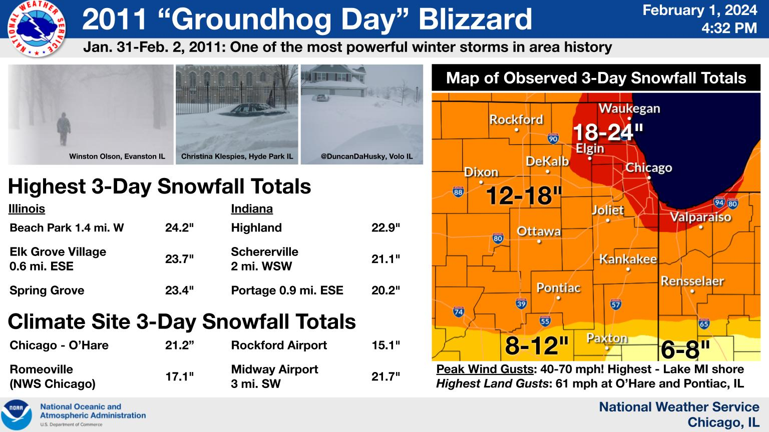 |
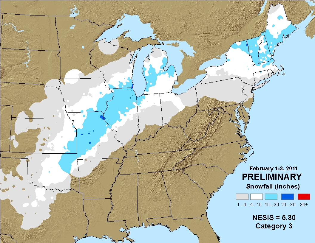 |
|||
| Local area snowfall | Regional snowfall |
Chicago 6-Hour Snowfall Accumulation Amounts
|
Chicago O'Hare Statistics January 31st-Feburary 2nd Three-Day Storm Total Snowfall: 21.2" Third highest snowfallon record
Snowfall Total from the Afternoon of February 1st through the Morning of February 2nd: 20.0" Highest 24 hr snowfall on record
February 1st Snowfall Total: 13.6" 2nd highest February calendar day snowfall on Record - had been highest at the time
|
||||||||||||||||||||||||||||||
|
Rockford Statistics January 31st-February 2nd Three-Day Storm Total Snowfall: 15.1" Third highest snowfall on record
Snowfall Total from the Afternoon of February 1st through the Morning of February 2nd: 14.0"
Calendar Day Total for February 1st: 10.9"
|
||||||||||||||||||||||||||||||
|
Romeoville Statistics January 31st-February 2nd Three-Day Snowfall Total: 17.1"
Snowfall Total from the Afternoon of February 1st through the Morning of February 2nd: 16.3" |
||||||||||||||||||||||||||||||
Winds
Winds gusted to 45 mph to over 60 mph during the evening of February 1. The strongest winds were near the Lake Michigan shore. Here is a list of peak wind gusts observed:
CHICAGO LAKEFRONT   70
BURNS HARBOR        67
WAUKEGAN HARBOR     63
PONTIAC             61
CHICAGO OHARE       61
AURORA              59
ROMEOVILLE          59
CHICAGO MIDWAY      58
WEST CHICAGO        54
LASALLE/PERU        53
WAUKEGAN            53
CALUMET             53
JOLIET              52
DEKALB              52
ROCHELLE            49
KANKAKEE            49
WHEELING            49
ROCKFORD            48
LANSING             47
MICHIGAN CITY       46
MIDEWIN             44
STERLING            43
VALPARAISO          43
MORRIS              43
Historical Context
 |
|
How the 2011 Groundhog Day Blizzard compares to other historic winter storms that impacted Chicago. The table in this graphic was updated in 2025 with the assistance of local weather historian Frank Wachowski. |
Top Ten Snowfalls
Chicago
Snowfall records for Chicago date back to 1884. O’Hare Airport is currently the official observing site for Chicago. The 21.2 inches that fell with this storm is the third largest snowfall on record to occur in Chicago and made this Chicago's biggest snowstorm ever in the month of February. Here is a list of the top ten snowstorms (by total snowfall accumulation) to impact Chicago as of February 2025:
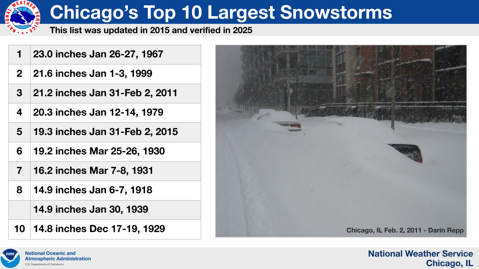 |
|
A listing of Chicago's top ten snowstorms by total snowfall accumulation |
Rockford
Snowfall records for Rockford date back to 1905. The Chicago-Rockford International Airport is currently the official observing site for Rockford. The 15.1 inches that fell with this storm is the third largest snowfall on record to occur in Rockford and made this Rockford's biggest snowstorm ever in the month of February. Here is a list of the top ten snowstorms (by total snowfall accumulation) to impact Rockford as of February 2025:
 |
|
A listing of Rockford's top ten snowstorms by total snowfall accumulation |
Photos
 |
 |
|||
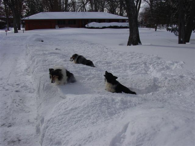
| From Lansing, IL (courtesy Kevin Paluch) | From Byron, IL (courtesy Gene Sisson) | |||
 |
 |
|||
| From Glen Ellyn, IL (courtesy Jessica Rawlings) | From Hyde Park, IL (courtesy Christina Klespies) |
 |
 |
|||
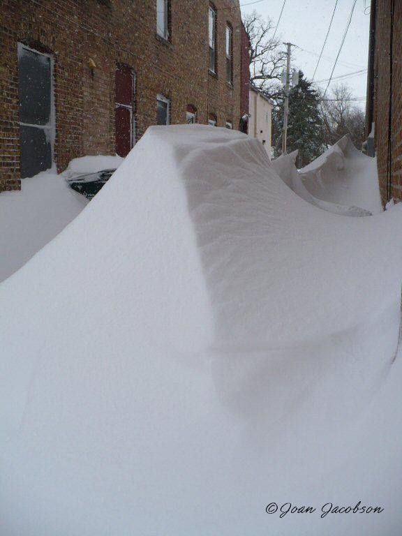
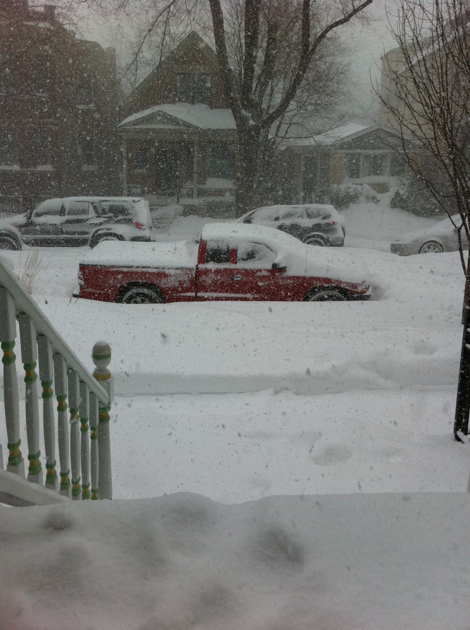
| From Richmond, IL (courtesy of Joan Jacobson) | From Logan Square, IL (courtesy of Krista) |
 |
 |
|||
| From Volo, IL (courtesy of Twitter follower @DuncanDaHusky) | From Richmond, IL (courtesy of Joan Jacobson) |
Radar
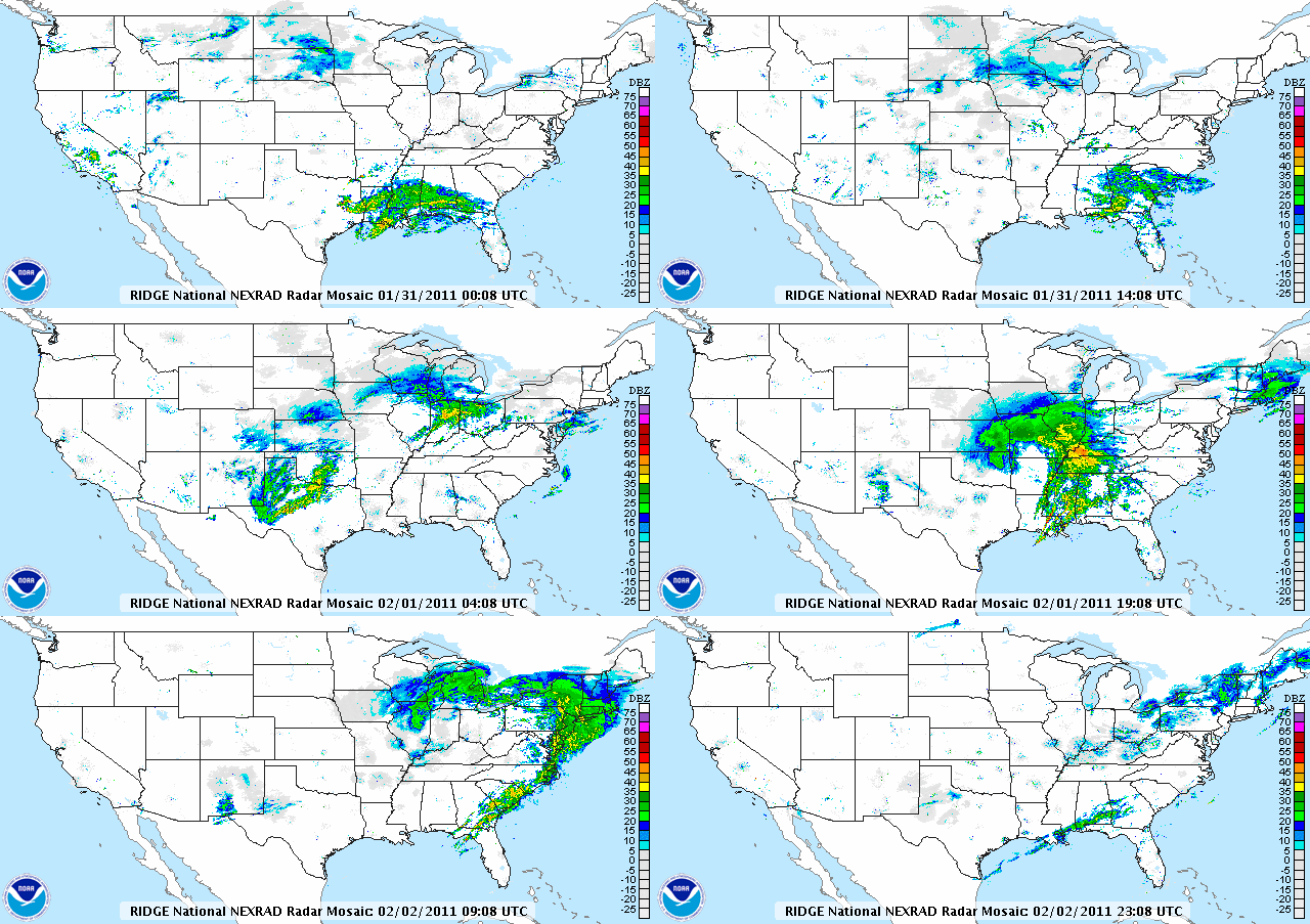 |
| Mosaic radar loop from January 31-February 2, 2011 |
Meteorology
This very complex and strong system which brought blizzard conditions across a large portion of the nation’s midsection on Tuesday, February 1, 2011, began to first show up in computer models by the middle part of last week. Although at that time, model guidance was widely variable in terms of placement and timing of this system. It wasn’t until this past weekend when guidance began to converge on a solution - one which would bring heavy snow, strong winds, and crippling conditions to northern Illinois and northwest Indiana. This would be in contrast to what has been observed so far this winter. Although the area has observed accumulating snowfall this winter, what had not been observed in some time is a storm moving in from the southwest - an orientation that is capable of ingesting copious amounts of moisture into the storm and provide widespread heavy amounts of snowfall.
Late January 31st into the early morning of the 1st, an upper level system and associated surface low began to eject out of the southern Plains. As this occurred, several different types of winter precipitation begin to overspread portions of the mid Mississippi valley. Despite some lake effect showers which developed early in the day Tuesday, the main area of accumulating snow did not reach the northern portions of Illinois and Indiana until after noon. At this time, the area of low pressure had reached southern Missouri and southern Illinois while strengthening. A large area of moderate to heavy snow just north of the strong low pressure system overspread much of the area. It’s during this time when this system furthered intensified as an upper level trough began to take on more of a negative tilt with strong pressure falls and rises being observed at the surface.
Several mesocale, or small scale, factors were occurring which helped bring more widespread intense snowfall to the area between the hours of 6PM Tuesday and 12AM Wednesday. With strong low pressure moving through east central Illinois, the deformation axis or snow band pivoted northwest over northern Illinois. This deformation axis provided snowfall rates of 1 to 2 inches per hour across the area for several hours before it began to shift out of the region. Mid and upper level forcing was greatest early in the evening as the upper level trough progressed northeast across the region. Then low and mid level forcing continued later in the evening as strong mid level frontogenitical forcing was observed for several hours.
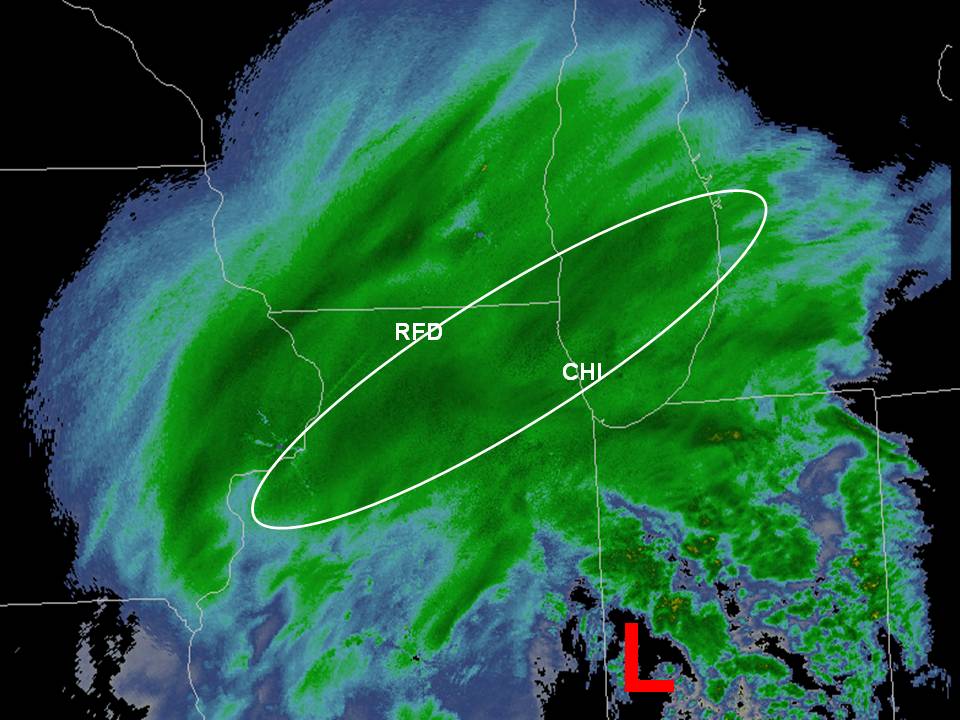 |
| Radar image with strongest forcing for heavy snow outlined |
By late February 1st and early morning on the 2nd, the system continued to quickly exit off of to the east. As this occurred, wrap around moisture shifted east across northern Illinois and northwest Indiana, helping to maintain a continuous light to moderate snowfall. It was also during this time that upper level flow began to shift such that this system snow transitioned more to lake effect snowfall. This next radar image indicates this with a band of lake effect snow originating from northern Lake Michigan southwest into southern Wisconsin and northeast Illinois. Also on this image are surface observations along Lake Michigan. There are two things to note with these observations. First, was the strong wind speeds, with gusts up to 50 MPH being observed. The second is with the orientation of these observations. Instability over the lake as well as a long fetch are essential for lake effect snow development. Another thing that helps more intense bands of snow to develop is surface convergence. Notice that several areas along the western shores of Lake Michigan have wind barbs which come together over eastern Wisconsin and Illinois. This is an indication that strong surface convergence is occurring. This strong convergence aided with this last area of more intense snow to fall over northeast Illinois through the middle part of the day on the 2nd, and then eventually into northwest Indiana late in the day on Wednesday as this all shifted to the east.
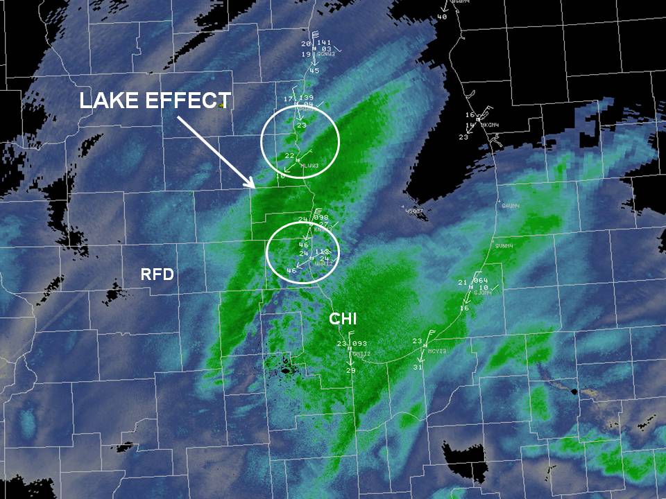 |
| Radar image with lake effect/enhanced snow outlined |
Lightning
Although lightning is not something you think of when discussing winter weather, it was observed all across the region on Tuesday, and really increased in frequency late on the night of February 1st. The image below show lightning strikes given by the Lightning Detection System setup across the U.S.
| Cloud-to-ground lightning strikes |
So what caused the lightning across the region on February 1st? For the development of spring time thunderstorms, several components are needed: lift or forcing, moisture, and instability. These components can also be discussed with winter time lightning. With a strong upper level trough and mid level frontogenesis, forcing was definitely not lacking with this event. This system was also able to pull in a good amount of moisture as it evolved over the central part of the country, providing the second component. The only component left to discuss, which would continue to provide good vertical motion for charge separation, or for the potential for lightning, is instability. The image below is a cross section of the atmosphere at around 6pm Tuesday night for areas in Madison, Wisconsin south to Champaign, Illinois with Ohare airport centered on the screen. The purpose of this image is to best describe the instability present over northern Illinois and northwest Indiana. The solid streamlines are essentially the vertical motion provided by system scale forcing as well as mid level frontogenitical forcing. The image in the background is our instability for this event. The blue colors, right above the best vertical motion, are the areas of this best instability. This instability helps any vertical motion rise faster and easier, which then helps with snowfall production and charge separation, or lightning. With summer time thunderstorms, what can happen when all of this is present is for hail to reach the ground. Now, of course, we are talking about the winter time so you would think that there would not be a need for a mention of hail. But there were several observations across the area of hail that did fall along with the snow.
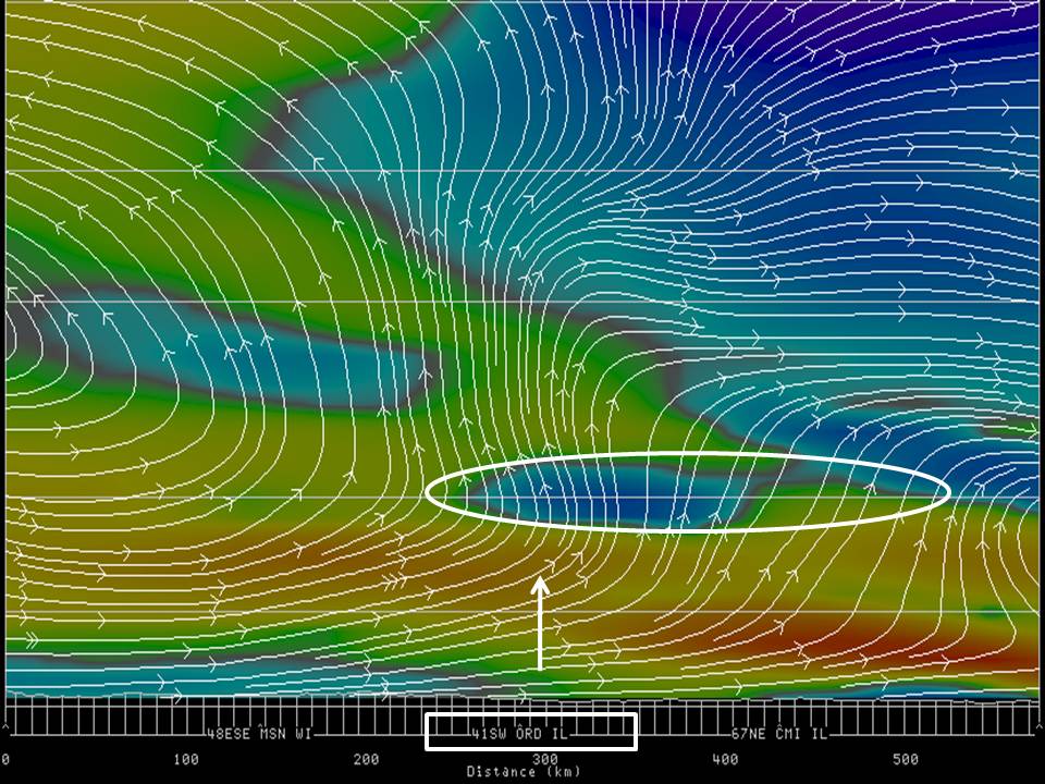 |
| Model analyzed cross section of the atmosphere highlighting key meteorological ingredients for heavy snowfall |
Winds
Not only did this strong area of low pressure bring very heavy snowfall across the region, but it also provided a setup for very strong winds which aided in the blinding blizzard conditions. A strengthening and unstable upper level trough provided an attendant strong surface low to deepen as it tracked northeast across portions of the Midwest. With this deepening low moving in from the south and a strong ridge of high pressure to the north, a strong pressure gradient setup across the Midwest late in the day on February 1st. These lines of pressure, or isobars, were tightly packed over much of the region, in particular northern Illinois and northwest Indiana. These tightly packed isobars associated with this strong area of low pressure were one indication for the potential for very strong winds during this event.
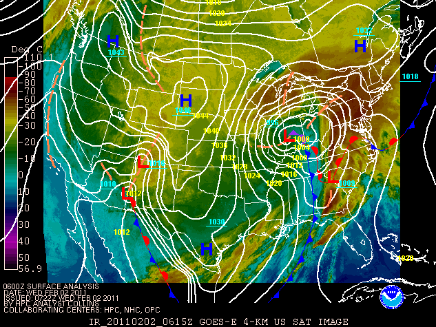 |
| Surface weather map from 12 a.m. February 2, 2011 with infrared satellite overlaid |
There were several other aspects to this system which also helped with very high wind speeds across the area on February 1st. One of which had to do with the mid and upper level portions of this system. This dynamic system brought with it very strong flow at all levels of the atmosphere, which included levels just off of the surface.
The images below are reanalyzed soundings, or vertical atmospheric profile plots, from the ERA-5 dataset. These are for a point near O’Hare Airport. The first part of this image to focus on is on the right, where wind barbs give the wind speed and direction at different level of the atmosphere. The wind barbs are indicating that winds of around 50 to 60 MPH are located only a couple of thousand feet off of the ground. With a well mixed lower part of the atmosphere, as can be seen with the thermal and moisture profile, these wind speeds can easily be transferred down to the surface, which is exactly what occurred late Tuesday night. Areas along the shore of Lake Michigan also saw stronger winds due to the fact that these winds were out of the northeast, which gave an unimpeded flow right off of the lake.
 |
 |
 |
| Re-analyzed sounding for 3 p.m. on February 1, 2011 (snow onset time) | Re-analyzed sounding for 8 p.m. on February 1, 2011 (heavy snow and incredibly strong wind) | Re-analyzed sounding for 2 p.m. on February 2, 2011 (continuing heavy snow and incredibly strong wind) |
| Generated from the ERA-5 dataset. | ||
Additional Information
Below is an article that was written in February 2011 providing additional context on the 2011 Groundhog Day Blizzard and how it stacked up to other historic winter storms that had impacted the Chicago area in prior decades.
Chicago’s Top Four Snowstorms – Which Was the Worst?
Jim Allsopp and Richard Castro, Feb 2011
There is a lot more to a snowstorm than the final tally of snowfall. We can also compare other components of winter storms, such as wind, temperature, and storm duration. With this in mind, how do Chicago’s top four winter storms compare? We looked at many measurable factors. It's important to remember the official observing site location. Midway Airport was the official climate site in 1967 and 1979. O’Hare was used for 1999 and 2011. Local weather historian Frank Wachowski also contributed to this story.
|
|
Jan 26-27 1967 |
Jan 12-14 1979 |
Jan 1-3 1999 |
Jan 31-Feb 2 2011 |
|
Snowfall (inches) |
23.0 |
20.3 |
21.6 |
21.2 |
|
Liquid equivalent (inches) |
2.40 |
1.36 |
1.39 |
1.57 |
|
Snow/liquid ratio |
9.6 to 1 |
14.9 to 1 |
15.5 to 1 |
13.5 to 1 |
|
Duration of accumulating snow (hours) |
~29 |
~38 |
~54 |
~40 |
|
Average snowfall intensity (inches per hour) |
0.8 |
0.5 |
0.4 |
0.5 |
|
Peak wind gusts (mph) |
53 |
39 |
43 |
61 |
|
Maximum snow depth (inches) |
23 |
29 |
18 |
18 |
|
Snow stayed on the ground through (number of days) |
March 9 42 days |
March 6 51 days |
January 23 21 days |
February 18 16 days |
|
Temperatures after the storm |
Jan 28-29 low 15/high 28 low 20/high 30 |
Jan 15-16 low -19/high 9 low -2/high 22 |
Jan 4-5 low -9/high 5 low -16/high 18 |
Feb 3-4 low -6/high 16 low 5/high 25 |
Looking at these numbers, the 1967 storm had the most snow, and the wettest/heaviest snow. It was also a very windy storm with significant drifting. The 1979 storm was followed by a brutal arctic blast and took the longest time to melt. Snow already on the ground from previous storms resulted in the deepest snow pack in 1979. The 1999 storm was massive and long lasting. It was also followed by very cold temperatures but not as much wind as the arctic blast following the 1979 storm. The 2011 storm had the most wind. We don’t have lightning data to compare, but this year’s storm likely produced more lightning than the other storms. Even small hail was reported at Midway the evening of February 1, 2011.
Only the 1967 and 2011 storms can be truly classified as blizzards, with sustained winds or frequent gusts of 35 mph or greater, and severely reduced visibility for a prolonged period of time. The 1979 storm had gusts over 35 mph toward the end of the event but didn’t have the reduced visibility. The visibility at O’Hare in this year’s storm was at or below ¼ mile for an incredible 11 consecutive hours from Tuesday evening into early Wednesday morning. Midway spent at least 2 hours late Tuesday evening with visibility down to 1/16 mile in heavy thundersnow and blowing snow.
The other component of the storms that is not as easy to quantify is the impact on commerce, transportation and human life. The 1967 storm paralyzed the city, shut down airports and closed schools for days. Estimates of 20,000 to 50,000 cars and 800 to 1000 buses were stuck or abandoned. About 60 people died as a result of the storm, 26 from heart attacks from snow shoveling.
The 1979 storm also caused severe problems with transportation. CTA trains weren’t equipped for snow removal and couldn’t get through the deep snow pack. Salt on railroad crossings also caused problems with CTA lines. O’Hare Airport was closed for 46 hours. Roofs collapsed under the weight of the snow. Chicagoans were so unhappy with the snow removal, that it played a key role in the following mayoral election.
The 1999 storm was well forecast, spread out over a long duration, and occurred on a long holiday weekend. Those factors helped mitigate the impact on transportation and commerce. Lake Shore Drive was shut down for the first time ever.
The 2011 storm was also well forecast. The advanced notice of the storm, better communications and planning, and better snow clearing techniques resulted in far less disruption. As a result, the number of stranded vehicles with this year’s storm was an order of magnitude lower than the 1967 blizzard, but the photos and footage of the stranded vehicles on Lake Shore Drive will leave an indelible imprint on the minds of many. Eleven people died as a result of the 2011 storm.
Anyway you look at it the January 31-February 2 blizzard certainly was an incredible storm, and one Chicagoans will talk about for years to come.
 |
Media use of NWS Web News Stories is encouraged! Additional recaps can be found on the NWS Chicago Science & Past Events Page. |
 |