A batch of severe weather affected Northern Illinois and Northwest Indiana on the evening of June 23rd, 2010 Severe winds and flooding were the main threats from these storms; however, several reports of funnel clouds were received throughout the event.
Meteorological Setup
An area of low pressure was centered over Iowa earlier in the day with a trailing cold front stretching southwest through Central Kansas. High pressure was centered over the Southeastern US allowing additional Gulf of America moisture to stream north into the Midwest. An upper level trough was located over Minnesota and Iowa with an anomalously strong 200hPa jet core of 100 knots to the north of the forecast area. A storm system from the previous night had dropped heavy rainfall with clouds lingering over much of Northern Illinois during the late morning and early afternoon. Ahead of the front, unseasonably strong southwest flow (Fig. 3 & 4) was pushing warm, moist air (Fig. 2 & 7) into Northern Illinois and Northwest Indiana. As skies cleared out in the afternoon, temperatures soared into the mid to upper 80s with dew points in the mid to upper 70s (Fig. 1). Mid level winds were quite strong, on the order of 50 knots as evident by a special 18Z upper air sounding from Quad Cities (KDVN) (Fig. 8). These stronger mid level winds an important factor in creating the strong shear to support the severe weather, and these strong mid level winds were also able to mix down to the surface with the severe thunderstorms.
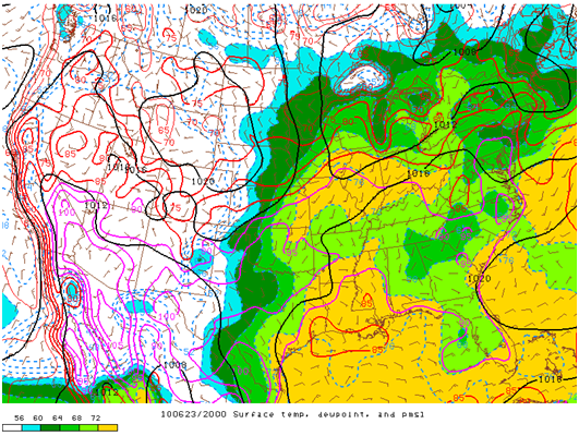
Figure 1: 3PM CDT Temperatures (lines) and dew points (shaded).As temperatures and dew points increased through the day, the atmosphere became explosively unstable. Thunderstorms initiated along the cold front in Southern Iowa by 4 PM CDT and by 5 PM (Fig. 5) storms quickly congealed into a line as they began to enter the northwestern counties of the Chicago forecast area.
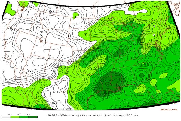
Figure 2: 3PM CDT Precipitable water (In) lowest 400hPa
In addition to the rapidly developing line of thunderstorms, precipitable water values (Fig. 2) were approximately 2” inches, which was nearly 4 standard deviations above normal (Fig. 7) at 7 PM CDT. The very moist atmosphere allowed for an enhanced flooding threat over already saturated soils of North Central Illinois and Northwest Indiana.
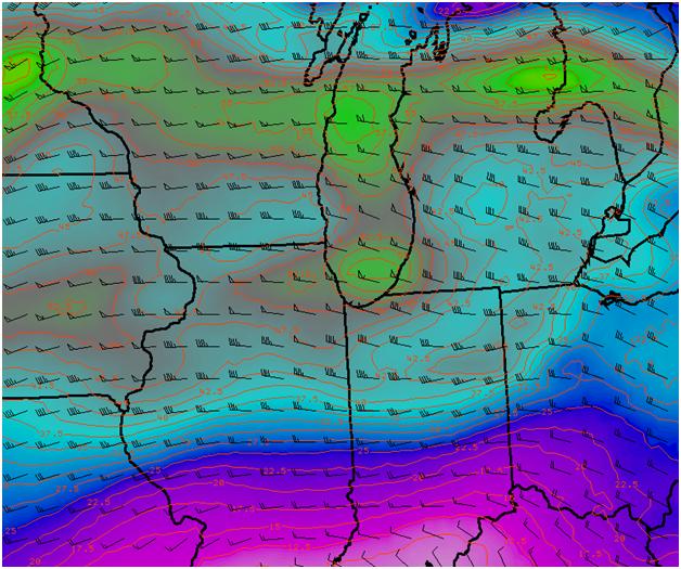
Figure 3: 1PM CDT 0-6KM Bulk Shear Isotachs and Values (shaded)
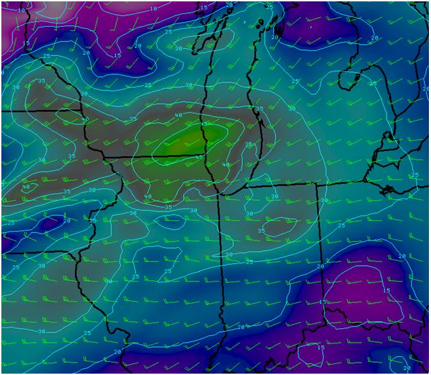
Figure 4: 10 AM CDT 850hPa Isotachs and Values (shaded)
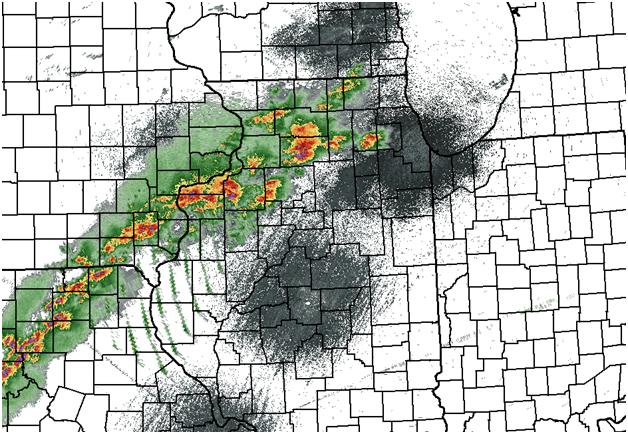
Figure 5: WSR-88D KLOT 5PM CDT Reflectivity.
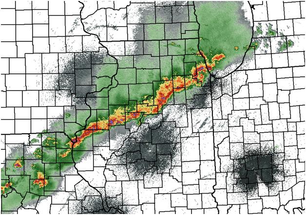
Figure 6: WSR-88D KLOT 6PM CDT Reflectivity.
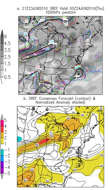
Figure 7: 21Z Jun. 23 2010 - SREF PWAT Anoms.
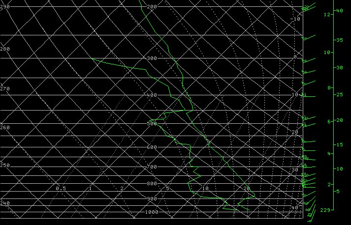
Figure 8: 18Z Sounding from KDVN
Damage Survey Results
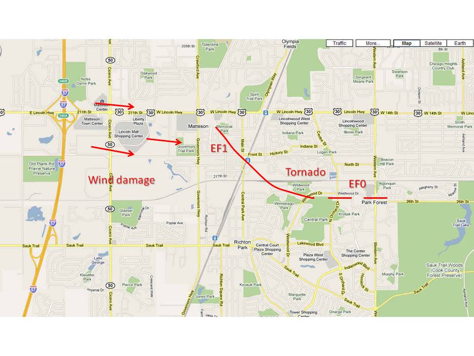
A National Weather Service meteorologist surveyed damage in Elmhurst-Oak Brook, and also in the Matteson-Park Forest area. It appears the damage in the Elmhurst and Oak Brook areas was caused by strong straight-line winds from a line of severe thunderstorms. An EF1 tornado occurred in Matteson and Park Forest.
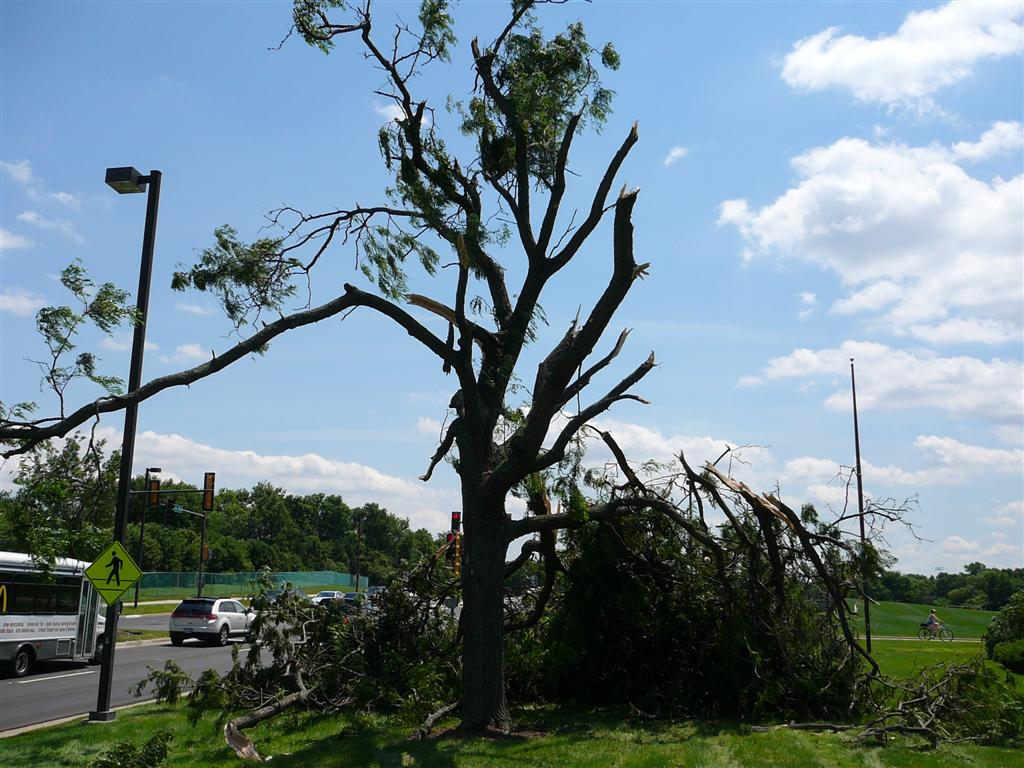
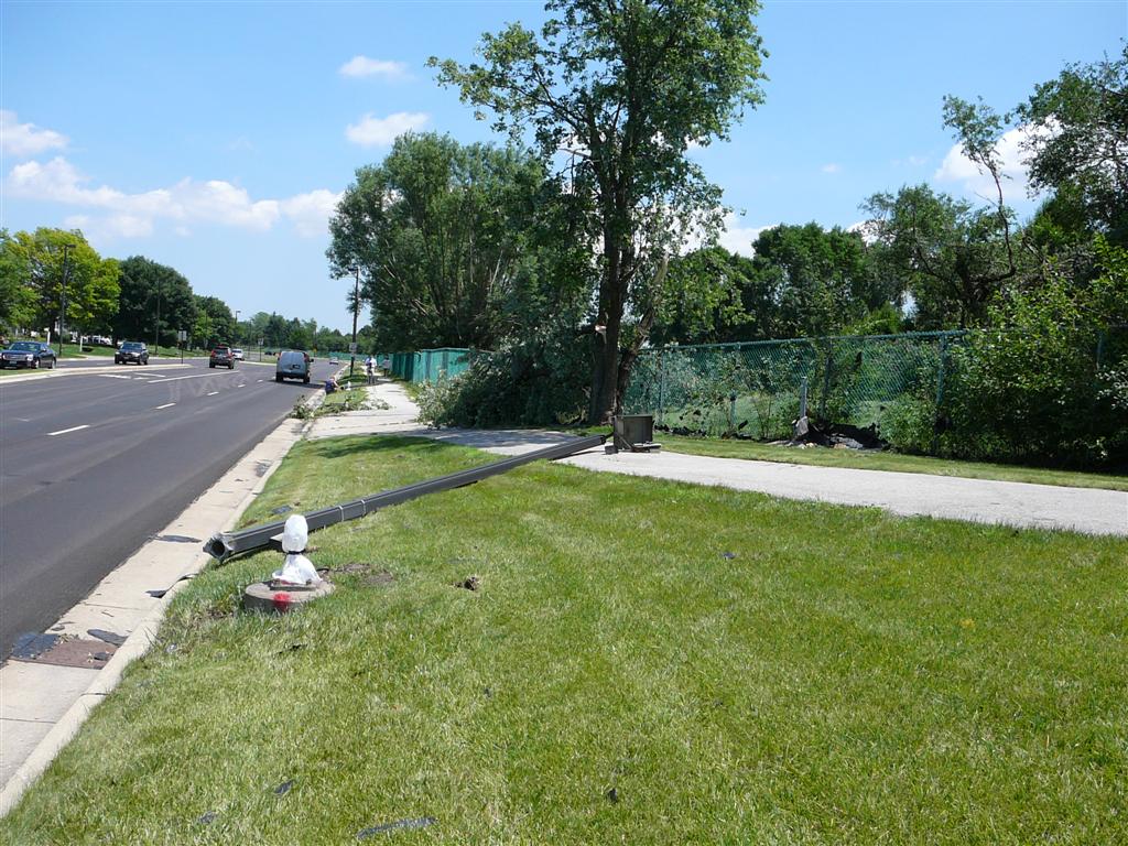
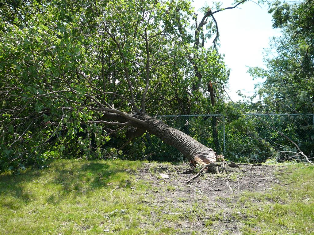
The damage in Oak Brook was spread out at least a mile wide. Damage consisted of numerous downed tree limbs and uprooted trees. There were signs and poles blown down, and roof damage to office buildings. The most intense damage was concentrated just southeast of the Oak Brook Shopping Center, near 22nd Street and Jorie Blvd. It appears that trees and debris were all blown down to the south-southeast. Due to the unidirectional debris pattern and the relatively wide swath of strong winds, it does not appear that a tornado occurred. Winds were likely gusting in excess of 90 mph.
In Matteson there was sporadic damage to commercial buildings across a half mile wide path along and south of Route 30 and Cicero Ave. Garage doors were blown in at a service station, and there was damage to roofs and HVAC units on roofs to a few buildings around the Lincoln Mall Shopping Center. There were a few trees blown down in a wooded area just southeast of the mall. A little farther east there was an intense narrow path of damage starting just southeast of the intersection of Lincoln Highway and Governors Highway. The concentrated path went from near Memorial Park to the train platform at Main Street and Hickory. In this neighborhood many large limbs were down and some trees were uprooted. A garage was destroyed and the roof of the train platform was damaged. Winds through this area were likely 90 to 105 mph, which is EF1 on the enhanced Fujita Scale. The path of the damage was from northwest to southeast, but many of the trees were blown from southwest to northeast, across the damage path. This indicated there was likely rotation. Several residents reported seeing rotation or a funnel cloud in this area. Lighter damage continued southeast of the railroad tracks near Wildwood park and east to the Norwood Plaza at Western and 26th Street. It appears that the tornado dissipated in the forest preserve near 26th Street. The tornado path was about 2 1/2 miles long and about 200 yards wide.
The following are images of storm damage in Oak Brook, IL submitted by NWS Cooperative Observer Patrick Skach.