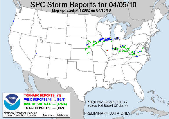
Severe thunderstorms moved across portions of northern Illinois Monday evening, producing wind damage and hail stones up to the size of baseballs. These storms formed on the nose of a 60 knot southwesterly low level jet, in a region of strong deep layer shear. The degree of vertical wind shear allowed a few storms to develop into supercells, which produced large hail and damaging winds, while others organized into linear segments which produced mainly damaging winds.
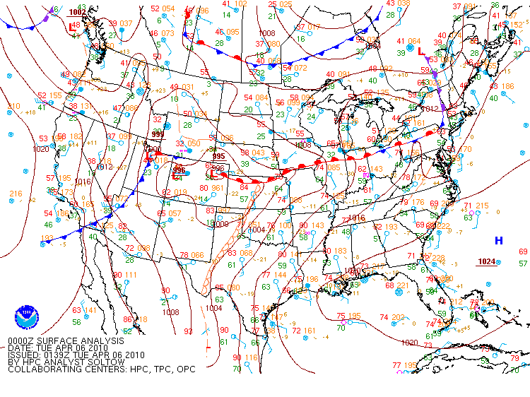
Image 1: Surface conditions at 7 pm Monday evening: Note the warm front lifting across northern Illinois.
The first severe thunderstorm developed over western Ogle County, around 9 pm. Storm tops rose to 45,000 feet, as this storm produced wind damage in the Polo and Oregon areas, along with 1 inch hail. The storm developed supercellular characteristics as it tracked quickly east, producing wind damage across the Rochelle and DeKalb areas.
While the intense supercell storm was a prolific damaging wind and large hail producer, the fact that the storm was well north of the surface warm front made it unlikely that it would produce a tornado. The instability, and inflow air for parcels rising into the updraft were located above the frontal inversion, which was roughly 5000-6000 feet above ground level.
Image 2: An aircraft descent sounding from the Greater Rockford Airport at 9:50 pm CDT, which indicates the stable near surface layer below the pink line, and the strong mid and upper level winds in excess of 50 knots above.
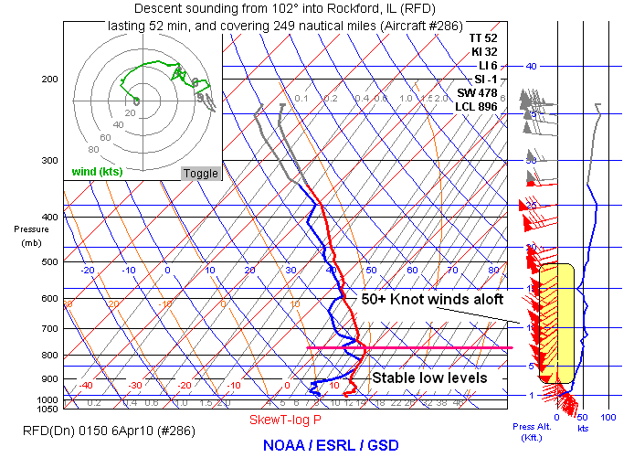
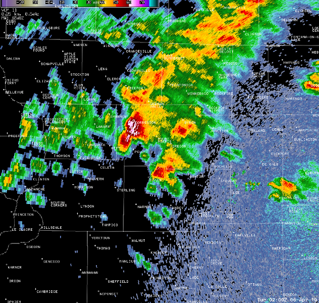
Image 3: Severe thunderstorm near Forreston and Polo at 9:00 pm CDT, in western Ogle County:
The storm continued to intensify as it entered the far western suburbs of Chicago around 10 pm CDT. By this time, the radar presentation showed clear supercelluar structure, with a very noticeable inflow notch and rear flank down draft appendage just east of DeKalb. A second slightly weaker storm to the north over southern Mc Henry County also displayed supercelluar radar characteristics, and produced wind gusts to 60 mph and 1 inch hail across the Huntley and Island Lake areas.
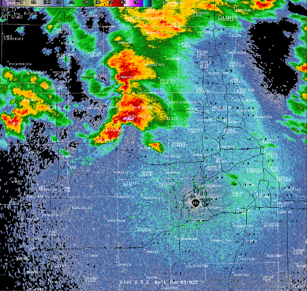
Image 4: Weaker supercell near Marengo, and the stronger storm moving into western Kane County at 10:02 pm CDT:
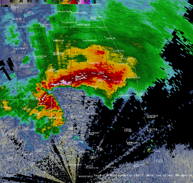
The DeKalb County supercell continued to strengthen as it moved across the western suburbs and across O’Hare International Airport around 10:45 pm. At this time, tennis ball to baseball sized hail was reported in the heavy precipitation core north of the airport in Des Plaines, while the rear flank downdraft produced a 68 mph wind gust at O’Hare, and produced wind damage in Bensenville. Many reports of 1 to 1.5 inch hail were received from the Streamwood, Hoffman Estates and Itasca areas as this storm moved through. The storm continued to produce large hail as it moved east across the Skokie, Niles and Evanston areas, while the strongest winds pushed across the north side of the City of Chicago. The Harrison Crib, 4 miles northeast of downtown Chicago, also recorded a wind gust to 68 mph as the storm moved out over Lake Michigan.
Image 5: The intense supercell moving across Des Plaines and O'Hare airport at 10:45 pm CDT:
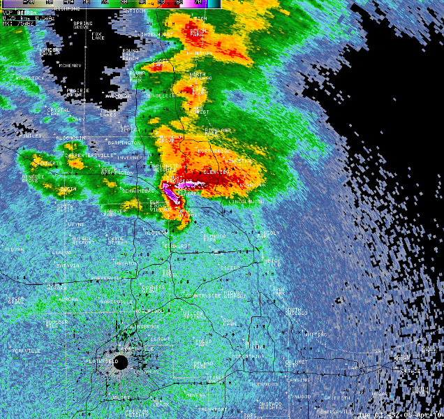
Image 6: The O'Hare supercell as seen by the O'Hare Terminal Doppler Weather Radar at 10:44 pm CDT. Note the well defined inflow notch, and the rear flank downdraft appendage wrapping around the west side of the airport:
A second round of severe storms developed over northwest Illinois by 11:00 pm, due to the persistent low level jet lifting warm, moist and unstable air above the warm front. These storms developed into a line of wind producing thunderstorms which produced wind damage across Rockford, Marengo, Huntley and Crystal Lake areas before weakening over the north side of Chicago after 1:00 am.
WFO Chicago, M. Ratzer April 6th, 2010

