Summary
|
 |
Tornadoes
Ashton EF1
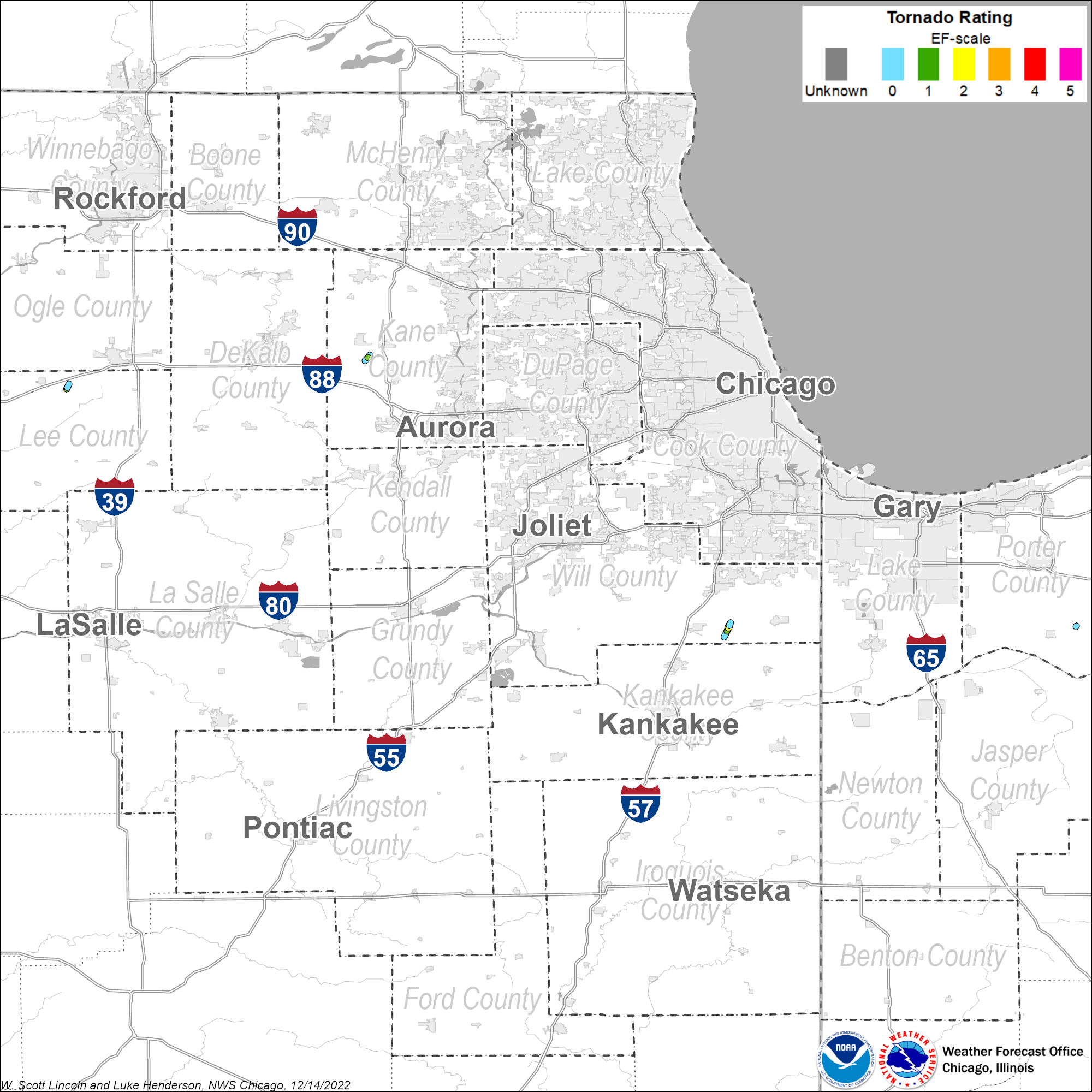
Summary: A tornado touched down near Meridian Road southeast of Ashton. The damage path was convergent and narrow. Some of the damage included a couple of outbuildings with poor structural integrity and a few that had their roofs ripped off. The top of a metal silo was 'punched' in and a grain cart was flipped onto its side. In addition to the structural damage, numerous 2x4's were speared into the ground and metal siding was strewn into the fields to the northeast of the farm. This tornado had a path length of 1.1 miles and a maximum width of 50 yards. The tornado started at 5:41 AM and ended at 5:43 AM. |
Elburn EF1
Summary: The tornado that was northwest of Elburn touched down in a corn field about one mile north of Route 38, west of Francis Road. The tornado closely followed Francis Road and was on the ground for about a mile. At the max width, the tornado was about 20 yards wide. The path touched three farmsteads and one home. The first farmstead that was affected sustained high end EF0 damage. An old garage and a small barn were leveled on the property, the roof was damaged on another building, and the trees on the property also sustained damage. There were several tree branches down around the property, and the trunk of a healthy pine tree was completely snapped. The second farmstead affected was located about a half mile up Francis Road. A temporary storage structure on the property was not constructed with any sort of wood or metal covering, but a heavy duty tarp-like material, heavily secured to the metal skeleton. The tarp was torn away from most of the metal structure, but still remained attached at one end. Several other buildings on the property, which were permanent, remained undamaged. The third and final farmstead affected was the most heavily affected area along the tornado's path. The farmstead was located about a quarter mile up Francis Road. Two large barns and one grain bin were completely destroyed on this property, and a telephone pole was completely snapped at the base. This tornado had a path length of 0.9 miles and a maximum width of 20 yards. The tornado began at 6:55 AM and ended at 6:57 AM. |
Peotone EF2
Summary: A tornado touched down about 4 miles east of Peotone. The tornado produced its most intense damage along South Will Center Road, about halfway between Corning Road and Peotone-Beacher Road, removing a house's roof, collapsing exterior walls on the second floor of the house, and completely destroying a garage and three other outbuildings. Two teenage boys were injured in the house. Four power poles were also downed just northeast of the area along Peotone-Beecher Road. Additional EF1 and EF0 damage was found along a path running southwest toward Kennedy Road. This damage consisted of collapsed outbuildings, snapped cedar trees, and damage to homes. One home on Corning Road was pushed off its foundation and the chimney collapsed. This tornado had a path length of 2.3 miles and a maximum width of 200 yards. The tornado began at 7:40 AM and ended at 7:44 AM. |
Kouts EF0
Summary: This tornado damaged a farm outbuilding. This tornado had a path length of 0.1 miles and a maximum width of 30 yards. The tornado started at 8:33 AM and ended at 8:34 AM. |
The Enhanced Fujita (EF) Scale classifies tornadoes into the following categories:
| EF-0 Weak 65-85 mph |
EF-1 Moderate 86-110 mph |
EF-2 Significant 111-135 mph |
EF-3 Severe 136-165 mph |
EF-4 Extreme 166-200 mph |
EF-5 Catastrophic 200+ mph |
 |
|||||
Straight-Line Winds
PRELIMINARY LOCAL STORM REPORT...SUMMARY
NATIONAL WEATHER SERVICE CHICAGO/ROMEOVILLE IL
224 PM CDT THU OCT 28 2010
..TIME...   ...EVENT...      ...CITY LOCATION...     ...LAT.LON...
..DATE...   ....MAG....      ..COUNTY LOCATION..ST.. ...SOURCE....
            ..REMARKS..
0633 AM     NON-TSTM WND GST 3 NNW DIXON             41.89N 89.51W
10/26/2010  M71.00 MPH       LEE                IL   TRAINED SPOTTER

            RECORDED BY COCORAHS OBSERVER.
0953 AM     NON-TSTM WND DMG WOODSTOCK               42.31N 88.44W
10/26/2010                   MCHENRY            IL   PUBLIC

            TREE BRANCHES DOWN.
1028 AM     NON-TSTM WND GST WAUKEGAN                42.37N 87.87W
10/26/2010  M62.00 MPH       LAKE               IL   ASOS
1103 AM     NON-TSTM WND GST PERU                    41.34N 89.13W
10/26/2010  M58.00 MPH       LA SALLE           IL   AWOS
1110 AM     NON-TSTM WND GST 5 SSE BEACH PARK        42.36N 87.81W
10/26/2010  M56.00 MPH       LMZ740             IL   OFFICIAL NWS OBS

            49 KNOT GUST MEASURED AT WAUKEGAN HARBOR GLOS WEATHER
            STATION.
1215 PM     NON-TSTM WND GST 4 NE CHICAGO            41.92N 87.57W
10/26/2010  M75.00 MPH       LMZ741             IL   C-MAN STATION

            65 KNOT GUST MEASURED AT CHICAGO CRIB.
0100 PM     NON-TSTM WND GST 3 NE TOWN OF PINES      41.73N 86.91W
10/26/2010  M62.00 MPH       LMZ046             IN   C-MAN STATION

            53 KNOT GUST MEASURED AT MICHIGAN CITY C-MAN STATION.
0510 PM     NON-TSTM WND DMG 1 NE ELBURN             41.90N 88.46W
10/26/2010                   KANE               IL   TRAINED SPOTTER

            POWER LINE FELL ONTO A HOUSE...RESULTING IN A LARGE FIRE
            ON A FARM ALONG IL-38.
1230 PM     NON-TSTM WND DMG YORKVILLE               41.64N 88.45W
10/27/2010                   KENDALL            IL   FIRE DEPT/RESCUE

            WIND GUST GREATER THAN 50 MPH AT FIRE HOUSE. A 6 FT LONG
            BRANCH /GREATER THAN 12 INCHES IN DIA/ FELL ON A
            RESIDENTIAL DRIVEWAY.
0200 PM     NON-TSTM WND GST 3 NNW BURNS HARBOR      41.65N 87.15W
10/27/2010  M55.00 MPH       LMZ745             IN   OFFICIAL NWS OBS

            48 KNOT GUST MEASURED AT BURNS HARBOR GLOS WEATHER
            STATION.
0206 PM     NON-TSTM WND GST WAUKEGAN                42.37N 87.87W
10/27/2010  M61.00 MPH       LAKE               IL   ASOS
0243 PM     NON-TSTM WND GST PERU                    41.34N 89.13W
10/27/2010  M58.00 MPH       LA SALLE           IL   AWOS
0250 PM     NON-TSTM WND GST 5 SSE BEACH PARK        42.36N 87.81W
10/27/2010  M56.00 MPH       LMZ740             IL   OFFICIAL NWS OBS

            49 KNOT GUST MEASURED AT WAUKEGAN HARBOR GLOS WEATHER
            STATION.

0345 PM     NON-TSTM WND GST GALE                    41.60N 87.34W
10/27/2010  M61.00 MPH       LAKE               IN   AWOS
0400 PM     NON-TSTM WND GST 4 NE CHICAGO            41.92N 87.57W
10/27/2010  M76.00 MPH       LMZ741             IL   C-MAN STATION

            66 KNOT GUST MEASURED AT CHICAGO CRIB.
0420 PM     NON-TSTM WND DMG DE KALB                 41.93N 88.75W
10/27/2010                   DEKALB             IL   TRAINED SPOTTER

            ROOF BLOWN OFF OF AN APARTMENT BUILDING ON GREENBRIER RD.
0515 PM     NON-TSTM WND GST 3 NE TOWN OF PINES      41.73N 86.91W
10/27/2010  M64.00 MPH       LMZ046             IN   C-MAN STATION

            56 KNOT GUST MEASURED AT MICHIGAN CITY C-MAN STATION.
0819 PM     NON-TSTM WND GST ROCKFORD                42.27N 89.06W
10/27/2010  M58.00 MPH       WINNEBAGO          IL   ASOS
Radar
|
|
|
Environment
A very powerful, near-record low pressure system over Minnesota pushed a cold front across northern Illinois and northwest Indiana on the morning of Tuesday, October 26th, 2010 which aided in the development of strong to severe thunderstorms. Thunderstorms stretched all the way from northern Wisconsin across Illinois and into Missouri. Storms intensified in a line as they crossed northern Illinois just prior to daybreak. Several storms were able to develop rotating updrafts which can lead to wind damage and, in some cases, tornadoes. Numerous reports of damage were received from a variety of areas including Kane, Will, Kankakee, and Iroquois Counties in Illinois and in Porter County in Indiana.
The storm system's minimum pressure of 955.2 millibars recorded at Bigfork, Minnesota, on October 26 is among the lowest extratropical sea level pressure values on record books in the mainland United States, excluding the west and east coasts.
|
|
|
The cold front associated with the area of low pressure generated an expansive line of showers and thunderstorms extending from Wisconsin to Missouri. Although damaging straight-line winds were at times associated with this squall line, the strength of the low pressure system also generated widespread areas of strong winds away from showers and storms.
|
|
|
Peak Non-Thunderstorm Wind Gusts
PUBLIC INFORMATION STATEMENT
NATIONAL WEATHER SERVICE CHICAGO IL
1202 PM CDT THU OCT 28 2010/102 PM EDT THU OCT 28 2010/

...ANOTHER DAY OF STRONG WINDS ON WEDNESDAY...

IT WAS ANOTHER WINDY DAY AS STRONG WINDS ASSOCIATED WITH THE STORM
SOME ARE DUBBING "CHI-CLONE 2010" CONTINUED TO BUFFET THE AREA.

HERE IS A SUMMARY OF THE OFFICIAL PEAK WIND GUSTS RECORDED FROM ASOS
SITES AROUND THE REGION WEDNESDAY...

WAUKEGAN       - 61 MPH (206 PM)
ROCKFORD       - 58 MPH (819 PM)
AURORA         - 55 MPH (320 PM)
MIDWAY         - 55 MPH (336 PM)
O`HARE         - 55 MPH (350 PM)
WEST CHICAGO   - 54 MPH (112 PM)
VALPARAISO     - 53 MPH (246 PM)
WHEELING       - 51 MPH (210 PM)


THE FOLLOWING IS A LIST OF MAXIMUM WIND GUSTS REPORTED AT AREA AWOS
SITES. NOTE: THESE SITES ARE NOT QUALITY CONTROLLED BY THE
NATIONAL WEATHER SERVICE. ALSO...AWOS SITES DO NOT REPORT PEAK
WINDS AND THE MAXIMUM WINDS HERE ARE BASED ON OBSERVATIONS
TRANSMITTED EVERY 20 MINUTES.

GARY           - 61 MPH (345 PM)
LASALLE/PERU   - 58 MPH (243 PM)
LOCKPORT       - 54 MPH (245 PM)
LANSING        - 53 MPH (244 PM)
PONTIAC        - 52 MPH (225 PM)
MORRIS         - 51 MPH (225 PM)
STERLING       - 50 MPH (435 PM)
KANKAKEE       - 50 MPH (244 PM)
DEKALB         - 47 MPH (205 PM)
JOLIET         - 46 MPH (243 PM)
ROCHELLE       - 45 MPH (345 PM)

THE FOLLOWING PEAK WIND GUSTS ARE FROM VARIOUS PRIVATE AND SCHOOL
WEATHER STATIONS AND ARE ALSO NOT QUALITY CONTROLLED BY THE NATIONAL
WEATHER SERVICE.

NAPERVILLE       - 56 MPH
GLENVIEW         - 54 MPH
LINCOLNSHIRE     - 53 MPH
MATTESON         - 53 MPH
MINOOKA          - 52 MPH
SAUK VILLAGE     - 52 MPH
WGN TV           - 52 MPH
GENEVA           - 51 MPH
LIBERTYVILLE EOC - 51 MPH
MARSEILLES       - 51 MPH
WHEATON          - 51 MPH
WAUKEGAN         - 50 MPH
ALGONQUIN        - 50 MPH
SCHAUMBURG       - 49 MPH
ORLAND PARK      - 49 MPH
MCHENRY          - 49 MPH
ADDISON          - 48 MPH
DEKALB           - 47 MPH
GURNEE           - 46 MPH
ITASCA           - 46 MPH
LINDENHURST      - 45 MPH
ELGIN            - 45 MPH
FOX LAKE         - 45 MPH
BUFFALO GROVE    - 44 MPH
LAGRANGE         - 44 MPH
PARK RIDGE       - 43 MPH
RENSSELAER       - 43 MPH
ONARGA           - 41 MPH

THE FOLLOWING ARE MAXIMUM WIND GUSTS RECORDED ON WEDNESDAY AT LAKE
MICHIGAN MARINE WEATHER STATIONS AND BUOYS OWNED AND MAINTAINED BY
NOAA.

CHICAGO CRIB (~85` EL)    - 76 MPH/66 KNOTS (400 PM)
MICHIGAN CITY (~70` EL)   - 64 MPH/56 KNOTS (515 PM)
NORTH BUOY (~11` EL)      - 59 MPH/51 KNOTS (950 AM)
WAUKEGAN HARBOR (~30` EL) - 56 MPH/49 KNOTS (250 PM)
BURNS HARBOR (~33` EL)    - 55 MPH/48 KNOTS (200 PM)
SOUTH BUOY (16` EL)       - 52 MPH/45 KNOTS (850 PM)
CALUMET HARBOR (~30` EL)  - 51 MPH/44 KNOTS (154 PM)
Photos
 |
 |
 |
 |
| EF2 damage to residence east of Peotone. (NWS Damage Survey) |
EF2 damage to farm buildings east of Peotone. (NWS Damage Survey) |
Debris path from tornado east of Peotone. (NWS Damage Survey) |
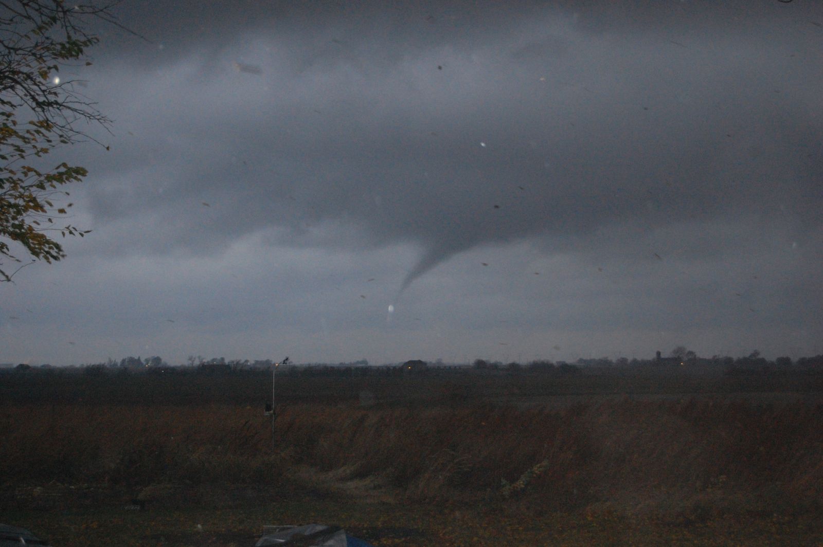
Funnel cloud near Peotone. (courtesy of Carol Cantone) |
 |
 |
||
| EF1 tornado damage northwest of Elburn (courtesy of Andrew Pritchard) |
EF1 tornado damage southeast of Ashton (NWS Damage Survey) |
 |
Media use of NWS Web News Stories is encouraged! Please acknowledge the NWS as the source of any news information accessed from this site. Additional recaps can be found on the NWS Chicago Past Events Page |
 |