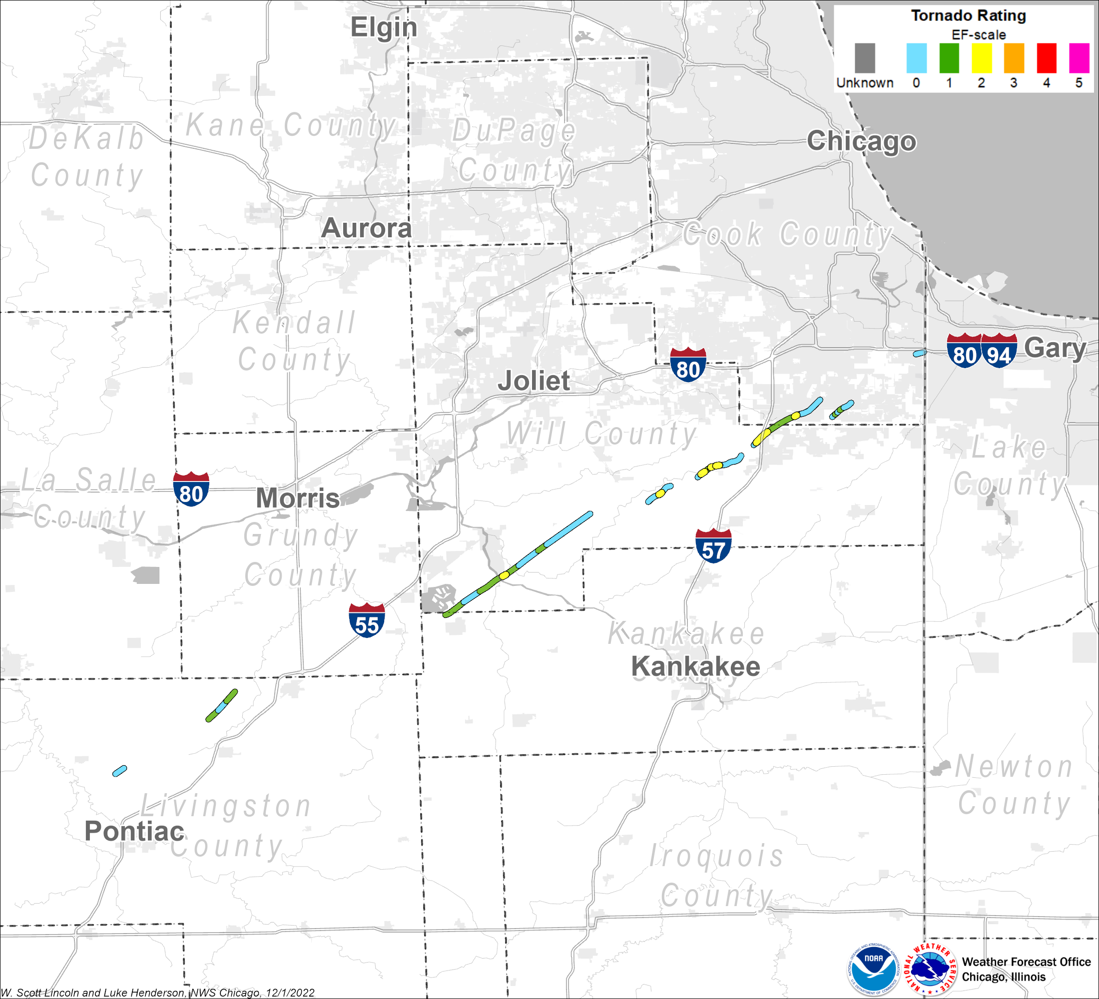
Summary
|
 |
Tornadoes
Cornell EF0
Summary: Video from a storm spotter along with eyewitness accounts from the Dwight Fire Department confirmed a weak tornado about four miles east of Cornell. The tornado remained in an open field and no damage or injuries were reported. |
Odell EF1
Summary: A tornado touched down near 2000E and 2900N. Utility poles were snapped along 2900N. On 2100E north of 3000N, half of the roof of a barn was blown off. At 3100N, a house suffered roof and tree damage. The tornado ended near 2200E, just south of 3200N. This tornado had a path length of 3.6 miles and maximum width of 40 yards. It began at 431 PM and ended at 445 PM. |
Essex Wilmington EF2
Summary: A tornado touched down in far northwest Kankakee County then crossed County Line Road into Will County north of Essex. Tree tops were sheared off at Essex and Cooper Roads. A clear path could be seen in the trees at McGuire Road. At Route 113 and Smiley Road near Custer Park, trees were snapped and uprooted. Across the Kankakee River, a two story house had its roof completely removed and there was extensive tree damage, with tornado damage rated EF2. The tornado continued across IL-102 near Ritchie where trees were damaged. The tornado crossed old Chicago Road near Kahler Road where power lines were blown down, a shed and barn were damaged and there was minor damage to a house. Another shed was destroyed. The tornado weakened as it moved from Symerton Road and Kennedy Road to Warner Bridge Road and Arsenal Roads. There was no damage except to one tree. There was minor damage to a barn and tree limbs north of Arsenal Road before the tornado dissipated. This tornado had a path length of 13.6 miles and a maximum width of about 200 yards. It began at 518 PM and ended at 546 PM. |
Wilton Center EF2
Summary: A tornado touched down northeast of Wilton Center, just north of US-52 and east of Elevator Road, where there was minor tree damage. Based on photos and eyewitness reports, the tornado grew to about 400 yards wide but remained in open fields with few structures or trees in its path. At 120th Avenue, a garage was destroyed and all that remained was a cinder block base. A metal outbuilding was severely damaged. The tornado ended near Manhattan-Wilton Road, just west of US-45. This tornado had a path length of 1.8 miles and a maximum width of 400 yards. It began at 551 PM and ended at 554 PM. |
Monee EF2
Summary: A tornado touched down along Paulding Road just west of Center Road, south of the Green Garden Country Club. A garage was leveled and a house had part of its roof torn off and damage to the second story exterior walls. At the southwest corner of Bruns and 88th Avenue, barns and trees were damaged. The tornado continued along Bruns Road between 80th and 88th Avenues. On the south side of Bruns Road, a barn and an outbuilding were completely destroyed. The house lost a large section of the southeast wall on the second floor. Another house was heavily damaged with siding and a west wall blown off. North of Bruns Road, there was a barn that was practically destroyed with only a partial wall standing. A horse barn was destroyed with the stables intact and horses still standing in them. In the backyard of the next home, there were trees blown down and debris, such as trailers and a small rowboat were blown into the creek immediately north of Bruns Road. A chain link fence was pulled from the ground. Many trees were uprooted and blown over. Power lines were also blown down. The next house had damage to two garages. The doors were blown out of both garages and the roof of one garage was severely damaged. The house had siding and roof shingles blown off. A house at the east end of this section on Bruns Road, closest to 80th Avenue, had siding blown off and chimney damage. The tornado ended southwest of the intersection of Harlem Avenue and Manhattan-Monee Road, where there was minor tree damage. This tornado had a path length of 3.7 miles and a maximum path width of 150 yards. It began at 555 PM and ended at 608 PM. |
Richton Park - Park Forest EF2
Summary: A tornado developed near Ridgeland Avenue and Dralle Road, where a high tension metal truss tower collapsed and four others were damaged. Power lines blocked I-57. The tornado destroyed a mobile home and outbuildings east of Ridgeland between Dralle and Stuenkel Roads before crossing I-57, where 6 persons were injured. The tornado was rated EF2 in this area. East of I-57 at Stuenkel Road, a large warehouse had bay doors blown in, much of the roof collapsed, and the west wall blown in. Utility poles were pushed over along South Central Avenue. The tornado crossed Steger Road into Cook County, just west of Cicero Avenue. The tornado hit a subdivision on the northwest corner of Steger Road and Cicero Avenue. Large tree limbs were blown down and a couple trees were uprooted. Homes were somewhat sheltered by large trees and only sustained minor damage. One home near Cicero Avenue had part of its roof torn off. East of Cicero Avenue, the tornado weakened slightly as it moved through an apartment complex. Only minor damage to roofs, soffits and siding was noted. The tornado hit another subdivision along Imperial Drive. A few homes had garages partially collapsed or destroyed. The tornado then passed through an open area before crossing Governors Highway and the Illinois Central tracks, just south of Sauk Trail. The tornado hit an apartment complex just east of the highway and railroad tracks. One three story building had much of the roof ripped off and part of the third floor exterior walls blown down. Carports were collapsed and other buildings had minor damage. The tornado was rated EF2 in this area. The tornado moved through the intersection of Sauk Trail and Richton Square Road where a grocery store and car wash sustained damage. The tornado then weakened to EF0 intensity as it continued northeast across Central Park Avenue and the northwest part of Central Park. Only minor damage to trees was observed in a subdivision in this area. The tornado then damaged a roof at an apartment complex near North Street and Orchard Drive. The last signs of tree damage were just southwest of the intersection of Lincoln Highway and Western Avenue. This tornado had a path length of 5.8 miles and a maximum width of about 150 yards. It began at 613 PM and ended at 630 PM. |
Chicago Heights EF1
Summary: A tornado touched down in South Chicago Heights in the Schubert's Woods Forest Preserve just north of Sauk Trail and west of Forest Preserve Drive. This tornado then tracked northeast across the forest, eventually emerging from the forest near Euclid and west 26th Streets. At this location, large trees were uprooted and portions of a roof were lifted off a large warehouse building. The tornado continued northeast across residential areas north of 26th Street and west of Chicago Road. In this neighborhood, several homes sustained minor damage with two houses sustaining significant damage from large trees falling onto the homes. The tornado continued northeast across Chicago Road eventually lifting near 16th Street and Center Street. Damage to trees was noted all along the path including several large uprooted or snapped in half. This tornado had a path length of 2.0 miles and a maximum width of about 75 yards. It began at 632 PM and ended at 637 PM. |
Lansing EF0
Summary: A brief tornado touched down near 179th street, east of Burnham Road and ended near the Indiana State line and 177th Street. Several tree limbs were blown down. One tree limb fell onto a car. This tornado had a path length of 0.7 miles and a maximum width of about 50 yards. It began at 648 PM and ended at 649 PM. |
The Enhanced Fujita (EF) Scale classifies tornadoes into the following categories:
| EF-0 Weak 65-85 mph |
EF-1 Moderate 86-110 mph |
EF-2 Significant 111-135 mph |
EF-3 Severe 136-165 mph |
EF-4 Extreme 166-200 mph |
EF-5 Catastrophic 200+ mph |
 |
|||||
Radar
|
Radar imagery at 436 PM CDT |
|
Radar imagery at 527 PM CDT |
|
Radar imagery at 541 PM CDT |
|
Radar imagery at 550 PM CDT |
|
Radar imagery at 604 PM CDT |
|
Radar imagery at 618 PM CDT |
|
Radar imagery at 627 PM CDT |
|
Radar imagery at 636 PM CDT |
|
Radar imagery at 650 PM CDT |
Environment
Supercells developed across LaSalle and Livingston County around 400 pm the afternoon on June 7. The first report of a tornado was received from Lasalle County in the Lostant area. A stronger low level circulation developed with a thunderstorm across Livingston County just northwest of Odell. Over the next few hours, the supercell thunderstorm produced several tornadoes as it moved northeast.
Photos
 |
|||
| Large tornado in Will County (courtesy of Amy Pavlik) |
 |
Media use of NWS Web News Stories is encouraged! Please acknowledge the NWS as the source of any news information accessed from this site. Additional recaps can be found on the NWS Chicago Past Events Page |
 |