Figure 1 Severe Thunderstorm over De Kalb county, Radar Reflectivity 1930 UTC (2:30 pm CDT)

Figure 2 Storm Relative Velocity2:30 pm CDT. Bright green colors are motion toward radar, red away from radar. Note implied strong rotation just south of city of De Kalb.

Figure 3 Hook Echo over Du Page County, 2014 UTC. This reflectivity structure strongly indicates low level rotation. EF1 tornado occurred at Winfield at 3:08 pm CDT, approximately 6 minutes prior to this image.

Figure 4 Storm Relative Velocity at time of hook echo. Note inbound (bright green) and outbound (bright red) associated with reflectivity hook structure over Du Page county. Thunderstorm over northwest Cook County also shows weaker broad rotation within its updraft, near Hoffman Estates.

Figure 5: 3:24 pm, Thunderstorms moving into Cook County. Although the hook echo has become less evident, velocity data indicates that the storm was still producing strong damaging straight line winds at this time.

Figure 6: Note bright red (outbound velocities from KLOT radar) near Mount Prospect, and Elmwood Park. These are approximately 70-80 mph wind maxima at roughly 1500-2000 feet AGL along the two most significant damage paths.

Figure 7 These wind maxima continued to the Lake Michigan Shore near Winnetka, and near the Wrigleyville neighborhood on the north side of Chicago.

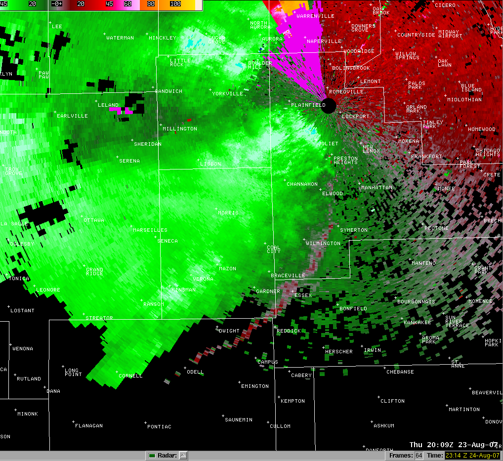
Figure 8 Meanwhile, farther south, at 3:09 pm a second severe thunderstorm was approaching the NWS office at Romeoville.

Figure 9 Velocity image at the same time as the reflectivity picture above. Bright green-blue colors near the radar (black circle, top right) indicate 72 knot (83 mph) inbound winds at roughly 260 feet above ground. A 67 mph wind gust was recorded at 3:14 pm.
PUBLIC INFORMATION STATEMENT
NATIONAL WEATHER SERVICE CHICAGO IL
747 PM CDT FRI AUG 24 2007

...STORM SURVEYS CONDUCTED ACROSS PORTIONS OF DEKALB...DUPAGE AND
COOK COUNTIES...

...STRAIGHT LINE WIND DAMAGE FOUND ACROSS DUPAGE AND COOK COUNTIES...

SEVERE THUNDERSTORMS CAUSED EXTENSIVE WIND DAMAGE ACROSS PORTIONS OF
NORTHERN ILLINOIS THURSDAY AFTERNOON. NATIONAL WEATHER SERVICE STORM
SURVEY TEAMS EXAMINED WIND DAMAGE IN SEVERAL LOCATIONS ACROSS
DEKALB...DUPAGE AND COOK COUNTIES ON FRIDAY.

ACROSS DUPAGE AND PORTIONS OF NORTHERN AND CENTRAL COOK COUNTIES...A
NEARLY CONTINUOUS SWATH OF WIND DAMAGE WAS NOTED. THE MOST
SIGNIFICANT DAMAGE OCCURRED ALONG A PATH WHICH BEGAN IN FAR WESTERN
DUPAGE COUNTY NEAR THE INTERSECTION OF ROOSEVELT ROAD AND
WASHINGTON STREET IN WEST CHICAGO...AND CONTINUED EAST THROUGH THE
NORTHERN PORTIONS OF LOMBARD AND GLEN ELLYN...INTO NORTHLAKE...THEN
ACROSS THE NORTH SIDE OF CHICAGO TO THE LAKE MICHIGAN SHORE NEAR
MONTROSE HARBOR. ALONG THIS PATH...WIND DAMAGE WAS CONSISTENT WITH
WINDS IN THE 60 TO 80 MPH RANGE. HOWEVER...THERE WERE POCKETS OF
WIND DAMAGE SUGGESTIVE OF WINDS IN THE 80 TO 100 MPH RANGE INCLUDING
THE 4200 BLOCK OF NORTH ASHLAND AND ACROSS NORTHERN GLEN ELLYN SOUTH
OF GENEVA ROAD. THE WIND DAMAGE WAS APPROXIMATELY ONE HALF MILE WIDE
ALONG THIS PATH. A SEPARATE AREA OF WIND DAMAGE SUGGESTIVE OF WINDS
OF 80 TO 100 MPH WAS FOUND IN THE 4000 BLOCK OF NORTH SHERIDAN IN
THE WRIGLEYVILLE AREA WITH EXTENSIVE TREE DAMAGE AND SEVERAL
UPROOTED TREES IN THIS AREA. MUCH OF THE DAMAGE APPEARS TO BE
CONSISTENT WITH STRAIGHT LINE WINDS...WITH NO SIGNS OF SUSTAINED OR
ORGANIZED CIRCULATION OVER THE MAJORITY OF THE DAMAGE PATH.

...EF1 TORNADO DAMAGE FOUND IN WESTERN DUPAGE COUNTY...

WHILE OTHER DAMAGE APPEARS TO HAVE BEEN CAUSED BY STRAIGHT LINE
WINDS...DAMAGE INDICATING A TORNADIC CIRCULATION WAS FOUND IN
WINFIELD IN WESTERN DUPAGE COUNTY. THE TORNADO BEGAN NEAR PRINCE
CROSSING ROAD SOUTH OF GENEVA ROAD. THE TORNADO HAD A PATH LENGTH OF
APPROXIMATELY 1.5 MILES AND ENDED JUST WEST OF GARY AVENUE SOUTH OF
GENEVA ROAD. THE MAIN DAMAGE FROM THE TORNADO INCLUDED SEVERAL LARGE
UPROOTED HARDWOOD TREES. BASED ON THE OBSERVED DAMAGE...THE TORNADO
IS ESTIMATED TO HAVE BEEN APPROXIMATELY 300 TO 500 YARDS WIDE AND
RATED EF1 ON THE ENHANCED FUJITA SCALE WITH ESTIMATED WIND SPEEDS OF
86 TO 110 MPH. PRELIMINARY REVIEW OF RADAR DATA AND SPOTTER REPORTS
INDICATE THAT THE TORNADO OCCURRED AT APPROXIMATELY 308 PM CDT.

...ADDITIONAL SURVEYS...

IN DEKALB COUNTY....MINOR STRAIGHT LINE WIND DAMAGE TO LIMBS AND A
SHED DOOR WERE FOUND ACROSS THE MILAN...AFTON...PIERCE AND KANEVILLE
TOWNSHIPS SOUTH AND SOUTHEAST OF THE CITY OF DEKALB.

IN MOUNT PROSPECT IN NORTHERN COOK COUNTY...ROOF AND EXTERIOR WALL
DAMAGE WAS NOTED TO A ONE STORY GARAGE BUILDING IN AN APARTMENT
COMPLEX SOUTHWEST OF THE INTERSECTION OF GOLF ROAD AND BUSSE ROAD.
DAMAGE APPEARED TO BE ASSOCIATED WITH STRAIGHT LINE WINDS OF 80 TO
100 MPH. THROUGHOUT THE VILLAGE...NUMEROUS LARGE BROKEN TREE
LIMBS...SOME UPROOTED TREES AND A FEW SNAPPED TREE TRUNKS ALSO
APPEARED TO BE CONSISTENT WITH PEAK STRAIGHT LINE WIND SPEEDS OF 80
TO 100 MPH.

$$

IZZI/MERZLOCK/MARSILI/RATZER