Chicago, IL
Weather Forecast Office
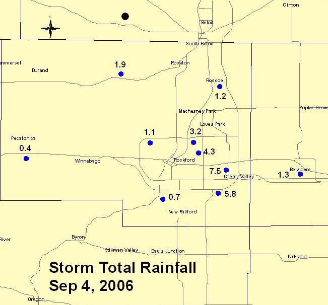
Slow moving thunderstorms produced torrential rainfall over Rockford IL on Labor Day (9/4/06). Nearly stationary storms dumped rain at rates as high as 3 inches/hr that quickly turned residential streets and roads into raging torrents. The greatest rainfall total received to date is 7.5 inches reported near the Cherry Vale mall. Hail covering the ground was also reported in isolated locations during the peak of the storm.
The heaviest rain fell over the southeast side of Rockford within the Keith Creek watershed. Runoff from the heavy rainfall resulted in rapid rises on Keith Creek. When the creek overtopped its banks, flood waters inundated nearby homes and businesses. Many homes were severely damaged when the force of the water caused basements to collapse and allowed flood waters to enter. Cars floated in streets and residents were rescued by boats.
Officials closely monitored Alpine Dam located in Aldeen Park as waters continued to rise. Fortunately water levels did not breach the spillway as more serious flooding would have occurred.
Representatives from the NWS Chicago office toured Rockford on Tuesday to survey the flood damaged areas and document the impacts.


Basement collapse from the force of the flood waters.

Alpine Dam. Note high water mark below spillway.
Hazards
Enhanced Hazardous Weather Outlook
Hazardous Weather Outlook
National Briefing
Storm Spotter Training and Seminars
Outlooks
Watch/Warning/Advisory Criteria
Snow Squall Warnings
Local Forecasts
Marine
Aviation
Fire
Text Products
Great Lakes Marine Portal
Lake Michigan Beach Forecast
El Nino
Snow and Ice Probabilities
US Dept of Commerce
National Oceanic and Atmospheric Administration
National Weather Service
Chicago, IL
250 George J Michas Dr.
Romeoville, IL 60446
815-834-1435 8am-8pm
Comments? Questions? Please Contact Us.

