Chicago, IL
Weather Forecast Office
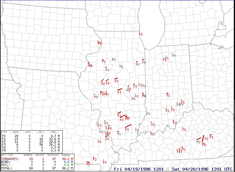
On April 19, 1996, a tornado outbreak occurred across the Midwest. A total of 39 tornadoes were observed across the state of Illinois, which (at the time) was the most tornadoes to occur in the state in a single severe weather event. This record has since been surpassed by the July 15, 2024 derecho event.
Four of these tornadoes occured in the forecast area covered by the NWS office in Chicago (also known as its 'County Warning Area' or CWA). A tornado in Zion rated F2 on the original Fujita Scale produced significant damage and resulted in two injuries.
The Zion tornado was somewhat unusual in multiple respects. First, as seen in the map above, it was by far the most northern of all the tornadoes during the event. It also was by far the latest tornado during the event, occurring about two hours after the previous tornado. Additionally, the tornado was rated as F2 which is considered a strong tornado, yet it was very short lived and occurred as part of a bowing line of storms rather than from an isolated supercell, as seen in this loop of Doppler radar Reflectivity (left side) and Base Velocity (right side):

| Location | County | F-Scale | Time (CST) | |
| Rutland | LaSalle | F1 | 4:40-4:41 PM | More information |
| Herscher | Kankakee | F0 | 5:25-5:29 PM | More information |
| Momence | Kankakee | F0 | 6:01-6:08 PM | More information |
| Zion | Lake, IL | F2 | 10:32-10:35 PM | More information |
Most of the Illinois tornadoes on this day occurred in areas covered by other National Weather Service offices. Here is some additional information about the event from those offices:
Hazards
Enhanced Hazardous Weather Outlook
Hazardous Weather Outlook
National Briefing
Skywarn
Outlooks
Watch/Warning/Advisory Criteria
Snow Squall Warnings
Local Forecasts
Aviation
Text Products
Marine
Fire
Enhanced Data Display (EDD)
Great Lakes Marine Portal
Lake Michigan Beach Forecast
El Nino
Snow and Ice Probabilities
Past Weather
Weather Event Write-Ups
Stormdata
Holiday Climate Data
Climate Plots
Education
NWS Training Portal
Play Time for Kids
Jetstream
Student Opportunities
US Dept of Commerce
National Oceanic and Atmospheric Administration
National Weather Service
Chicago, IL
250 George J Michas Dr.
Romeoville, IL 60446
815-834-1435 8am-8pm
Comments? Questions? Please Contact Us.


