| Fast Facts | Rainfall | Flooding | Symerton Tornado | Photos | Meteorology & Radar | Links |
Listing of June 15 Rainfall | Listing of June 15-16 Rainfall
Other Rainfall Notes:
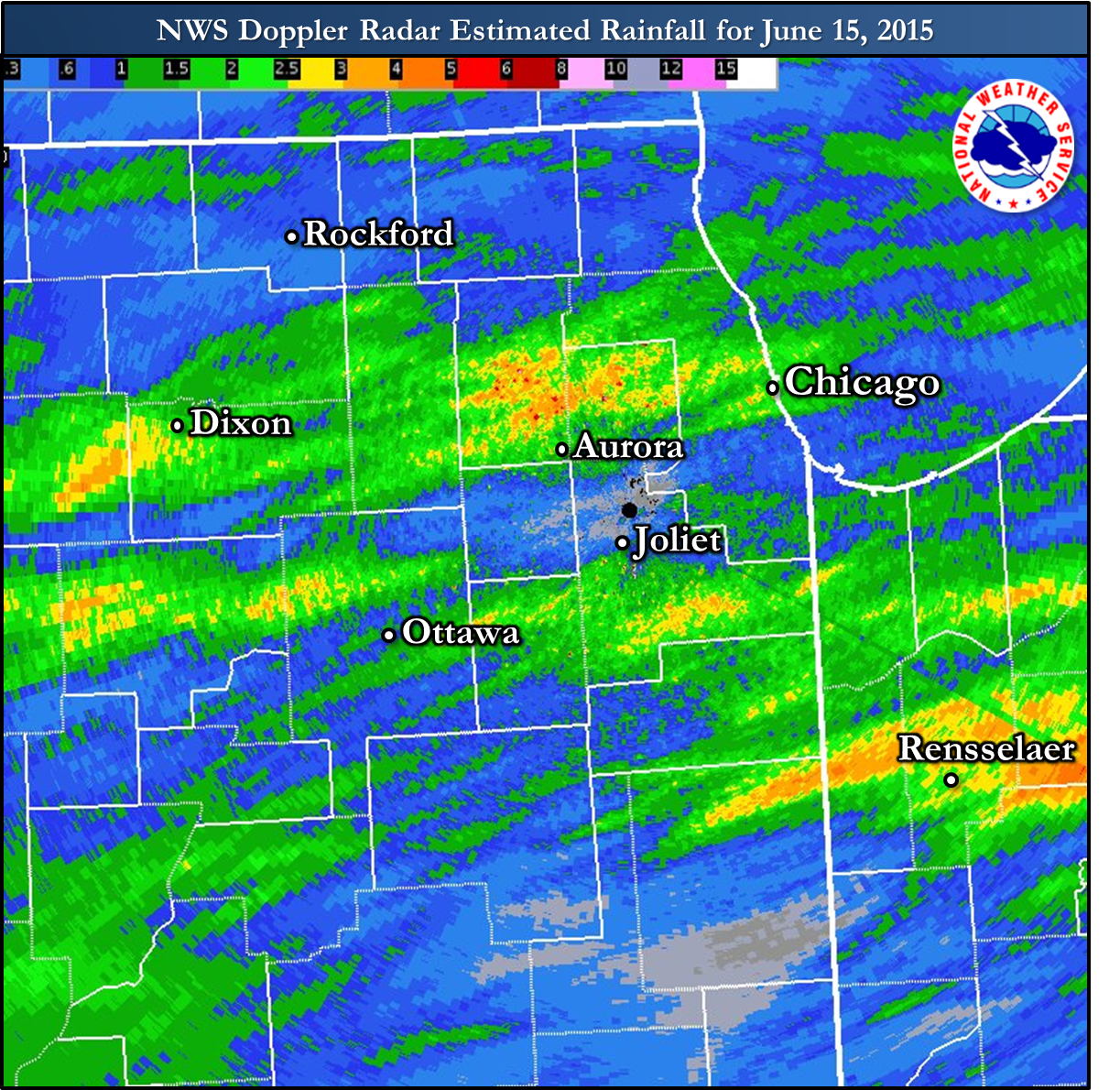
- The 2.56" observed at Chicago O'Hare International Airport on June 15th was a record for the calendar day, surpassing the old one of 0.96" in 1982. This was the highest daily rainfall amount since August 4, 2014 (2.76"). The five day total of rain from June 11th-15th is 3.96" and is the highest since April 15-19, 2013 (5.93").
- The 3.09" measured at Chicago DuPage Airport in West Chicago on June 15th, and the 2.86" at Aurora Airport in Sugar Grove were the highest calendar day precipitation totals for both sites since September 13, 2008. (both have a nearly complete warm season record through that time).
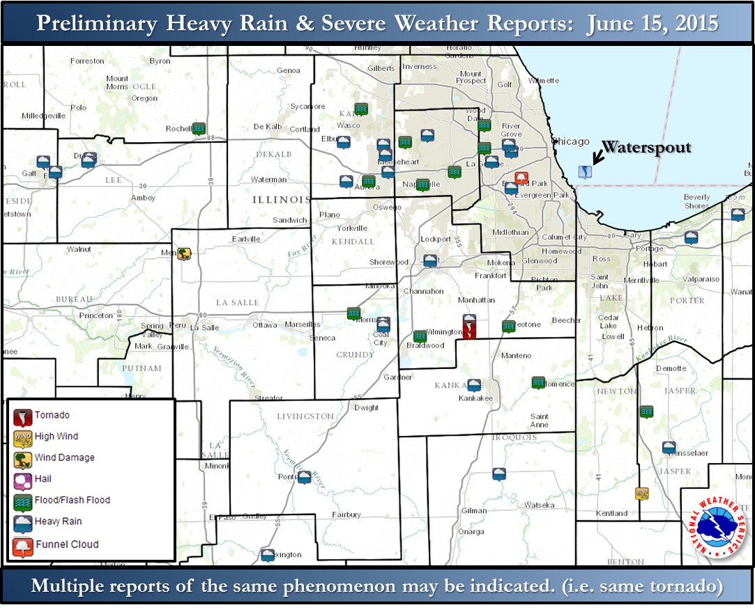
While the environment was not conducive for long-lived or powerful tornadoes, a brief tornado threat existed with a few rotating storms known as supercells. This included with two storms in central Cook County, primarily west of downtown Chicago. Each of these had funnel cloud reports. There was also a tornado reported near the Will/Kanakakee County border, not far from I-57. Based on a damage assessment conducted on Friday June 19th, an EF-1 tornado was confirmed near Symerton Illinois.
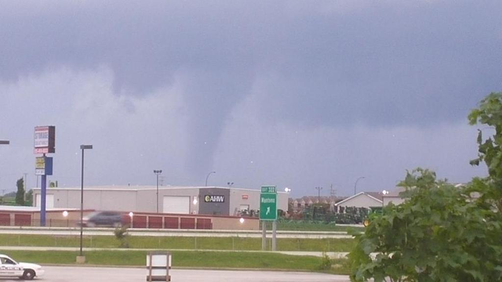 |
| From near Manteno. Shared with us by Kimberly Coffou. |
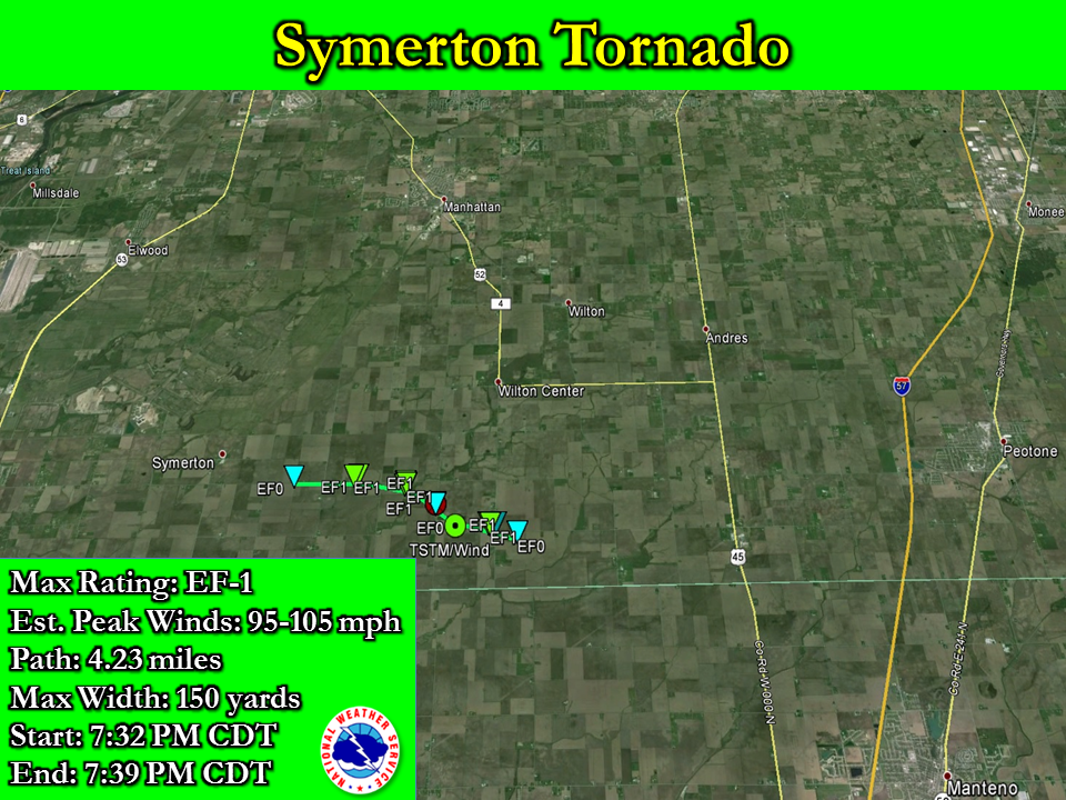
...NWS DAMAGE SURVEY FOR 06/15/2015 TORNADO EVENT...

...CONFIRMED EF-1 TORNADO NEAR SYMERTON IL...

SYMERTON TORNADO

RATING:                 EF-1
ESTIMATED PEAK WIND:    95-105 MPH
PATH LENGTH /STATUTE/:  4.23 MILES
PATH WIDTH /MAXIMUM/:   150 YARDS
FATALITIES: 0
INJURIES: 0

START DATE:             06/15/2015
START TIME:             07:32 PM CDT
START LOCATION:         1.39 MILES EAST-SOUTHEAST OF SYMERTON
START LAT/LON:          41.3215N / 88.0269W

END DATE:               06/15/2015
END TIME:               07:39 PM CDT
END LOCATION:           5.51 MILES SOUTHEAST OF SYMERTON
END_LAT/LON:            41.3055N / 87.9506W

SURVEY SUMMARY: THE TORNADO TOUCHED DOWN MONDAY EVENING AT 7:32
PM CDT 1.4 MILES EAST OF SYMERTON OR 12 MILES WEST OF
PEOTONE...SNAPPING LARGE TREE LIMBS WEST OF WARNER BRIDGE ROAD.
THE TORNADO MOVED EAST AND DOWNED TREES AND A POWER POLE ALONG
PEOTONE-WILMINGTON ROAD JUST WEST OF GOUGAR ROAD. THE TORNADO
THEN TURNED SOUTHEAST AND IMPACTED A KENNEL AND AN ADJACENT
RESIDENCE WHERE EF-1 DAMAGE WAS NOTED DUE TO ROOF AND TREE DAMAGE.
THIS INCLUDED MULTIPLE SNAPPED OR UPROOTED HARDWOODS AND
SOFTWOODS. THE TORNADO MOVED TOWARD TULLY ROAD AND FLIPPED
MULTIPLE 320 LB GRAIN BINS OVER A GARAGE AND INTO A FIELD ACROSS
TULLY ROAD. DAMAGE WAS ALSO NOTED TO METAL OUTBUILDINGS. THE
TORNADO CONTINUED SOUTHEAST AND IMPACTED TWO FARMSTEADS NEAR
KENNEDY AND CEDAR ROADS WHERE EF-1 DAMAGE OCCURRED TO TREES AND A
MACHINE SHED. METAL SIDING AND ADDITIONAL DEBRIS FROM THE SHED WAS
THROWN A HALF MILE DOWNSTREAM WHERE THE TORNADO DISSIPATED IN A
FIELD. THE TORNADO PATH ENDED 5.5 MILES EAST OF SYMERTON OR 7.5
MILES WEST OF PEOTONE AT 07:39 PM CDT.

EF SCALE: THE ENHANCED FUJITA SCALE CLASSIFIES
TORNADOES INTO THE FOLLOWING CATEGORIES.

EF0...WEAK......65 TO 85 MPH
EF1...WEAK......86 TO 110 MPH
EF2...STRONG....111 TO 135 MPH
EF3...STRONG....136 TO 165 MPH
EF4...VIOLENT...166 TO 200 MPH
EF5...VIOLENT...>200 MPH

NOTE:
THE INFORMATION IN THIS STATEMENT IS PRELIMINARY AND SUBJECT TO
CHANGE PENDING FINAL REVIEW OF THE EVENT AND PUBLICATION IN
NWS STORM DATA.

$$

RCASTRO/DNEAL/AKRULL
Link to pictures received from our Facebook Page for the June 15th event
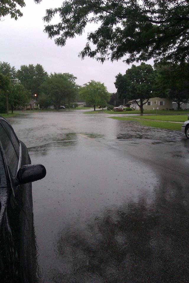 |
| Northeast side of Aurora. Courtesy of Debby Gray. |
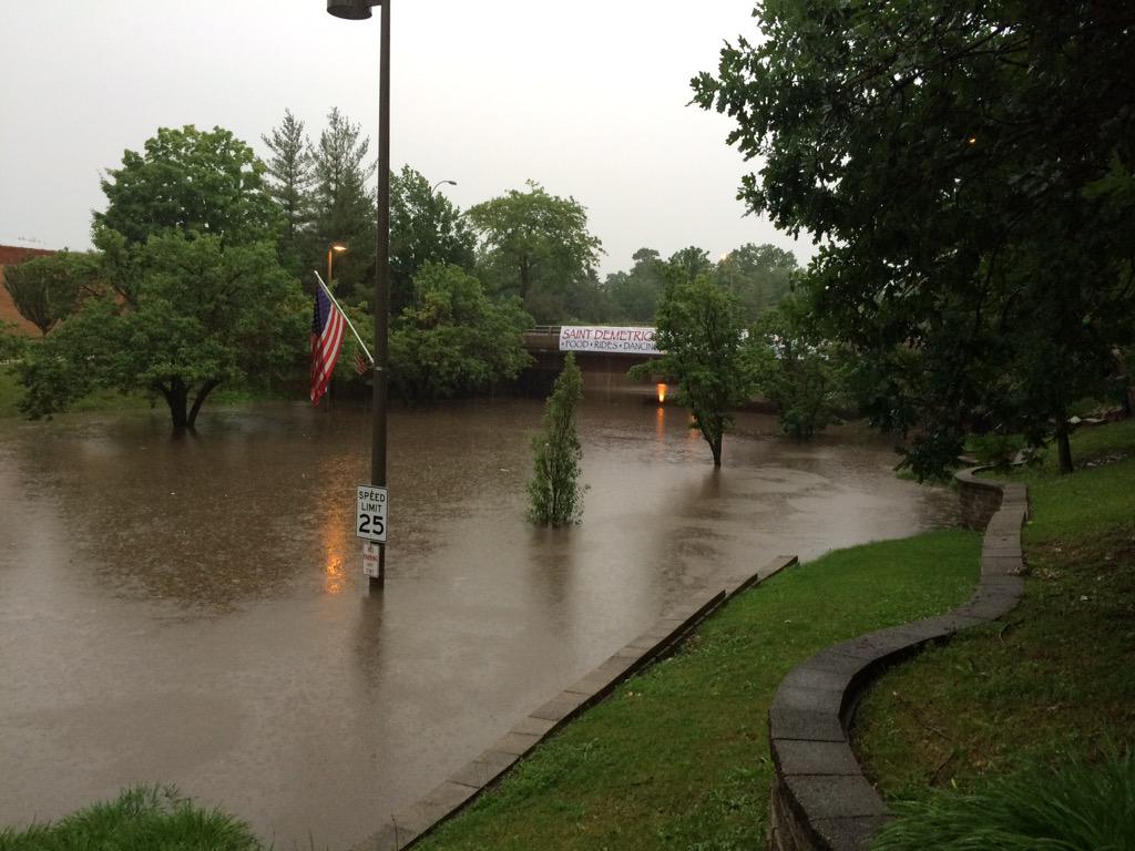 |
| York Road in Elmhurst. |
| NWS Chicago 0.5° Reflectivity: 8 am June 15 - 12:30 am June 16 (15m timesteps) |
 |
- June 13, 2015: Heavy Rain Event Briefly Closes I-80
- June 10, 2015: Record Large Hail in Minooka
- June 8, 2015: Numerous Hail Producing Storms, Including Up to Golf Ball Size

