Overview
|
June 9th Fast Facts:
June 10th Fast Facts:
|
|
June 9th Storm Reports
PRELIMINARY LOCAL STORM REPORT...SUMMARY
NATIONAL WEATHER SERVICE CHICAGO IL
1143 PM CDT TUE JUN 9 2020

..TIME...   ...EVENT...      ...CITY LOCATION...     ...LAT.LON...
..DATE...   ....MAG....      ..COUNTY LOCATION..ST.. ...SOURCE....
            ..REMARKS..

0250 PM     TSTM WND DMG     1 SSW STEGER            41.46N 87.64W
06/09/2020                   WILL               IL   PUBLIC

            REPORT OF DOWN POWER POLES IN THE STEGER
            AREA NEAR W RICHTON AND KINGS RD NEAR 235TH
            STREET. TIME ESTIMATED BASED ON RADAR.

0253 PM     TSTM WND DMG     1 W FAIRDALE            42.10N 88.96W
06/09/2020                   OGLE               IL   PUBLIC

            TREES UPROOTED, ROOF DAMAGE.

0255 PM     TSTM WND DMG     4 NNW FAIRDALE          42.15N 88.96W
06/09/2020                   OGLE               IL   FIRE DEPT/RESCUE

            ON THE ROAD BETWEEN WILLOUGHBY RD AND COUNTY
            LINE RD AN 18 DIAMETER TREE DOWN BLOCKING
            THE ROAD. REPORT VIA KIRKLAND FD.

0259 PM     TSTM WND DMG     1 SW ROCKFORD           42.26N 89.10W
06/09/2020                   WINNEBAGO          IL   LAW ENFORCEMENT

            TREE DOWN INTO POWERLINES NEAR WINNEBAGO AND
            MORGAN.

0259 PM     TSTM WND GST     LOWELL                  41.29N 87.42W
06/09/2020  M58 MPH          LAKE               IN   MESONET


0305 PM     TSTM WND DMG     OAK LAWN                41.72N 87.76W
06/09/2020                   COOK               IL   BROADCAST MEDIA

            DOWNED TREE ON CENTRAL AVE SOUTH OF 95TH.

0305 PM     TSTM WND DMG     1 SE BRIDGEVIEW         41.74N 87.79W
06/09/2020                   COOK               IL   TRAINED SPOTTER

            30 FT PINE TREE UPROOTED.

0306 PM     TSTM WND DMG     HOMETOWN                41.73N 87.73W
06/09/2020                   COOK               IL   TRAINED SPOTTER

            TREES DOWN, SHINGLES OFF ROOFS.

0306 PM     TSTM WND DMG     1 SSE BRIDGEVIEW        41.73N 87.80W
06/09/2020                   COOK               IL   PUBLIC

            PINE TREE UPROOTED.

0307 PM     TSTM WND GST     MIDWAY AIRPORT          41.78N 87.75W
06/09/2020  M62 MPH          COOK               IL   OFFICIAL NWS OBS


0310 PM     TSTM WND DMG     1 WSW OAK PARK          41.88N 87.80W
06/09/2020                   COOK               IL   PUBLIC

            TREE DOWN ACROSS ROAD.

0315 PM     TSTM WND DMG     1 SSW BELMONT-CRAGIN    41.91N 87.78W
06/09/2020                   COOK               IL   PUBLIC

            TREE DOWN BLOCKING THE ROAD.

0323 PM     TSTM WND GST     OHARE AIRPORT           41.98N 87.92W
06/09/2020  M60 MPH          COOK               IL   OFFICIAL NWS OBS

            CORRECTS PREVIOUS TSTM WND GST REPORT FROM
            OHARE AIRPORT.

0323 PM     TSTM WND DMG     OHARE AIRPORT           41.98N 87.90W
06/09/2020                   COOK               IL   NWS EMPLOYEE

            A SMALL DECORATION TREE DOWNED ALONG
            ENTRANCE ROADWAY INTO OHARE INTERNATIONAL
            AIRPORT. MULTIPLE OTHER MEDIUM TO LARGER
            SIZED LIMBS DOWNED ON AIRPORT PROPERTY.
            REPORTED BY NWS MIAMI SCIENCE AND OPERATIONS
            OFFICER.

0325 PM     TSTM WND DMG     ROGERS PARK - CHICAGO   42.01N 87.67W
06/09/2020                   COOK               IL   PUBLIC

            PORTION OF LARGE TREE DOWNED.

0326 PM     TSTM WND DMG     2 N WEST RIDGE - CHICAG 42.02N 87.70W
06/09/2020                   COOK               IL   BROADCAST MEDIA

            LARGE TREE BRANCHED DOWNED ON CHICAGO CTA
            RAIL LINE.

0329 PM     TSTM WND DMG     1 S ARLINGTON HEIGHTS   42.07N 87.98W
06/09/2020                   COOK               IL   TRAINED SPOTTER

            SPOTTER REPORTS LARGE 10 INCH DIAMETER TREE
            DOWN BLOCKING ARLINGTON HEIGHTS ROAD NORTH
            OF CENTRAL. TIME ESTIMATED BASED ON RADAR.

0331 PM     TSTM WND GST     ROSEMONT                41.99N 87.87W
06/09/2020  M74 MPH          COOK               IL   MESONET


0345 PM     HEAVY RAIN       1 NNE MACHESNEY PARK    42.36N 89.03W
06/09/2020  M0.97 INCH       WINNEBAGO          IL   MESONET

            0.97 INCHES IN AN HOUR, MOST OF IT FELL IN
            45 MINUTES.

0346 PM     TSTM WND DMG     1 NNE ISLAND LAKE       42.28N 88.18W
06/09/2020                   LAKE               IL   DEPT OF HIGHWAYS

            TREE DOWN BLOCKING BURNETT RD WEST OF
            DARNELL.

0625 PM     TORNADO          4 WNW ONARGA            40.75N 88.08W
06/09/2020                   IROQUOIS           IL   EMERGENCY MNGR

            PICTURES OF A BRIEF TORNADO WEST OF ONARGA.
            CONFIRMED BY EMERGENCY MANAGEMENT. TIME
            ESTIMATED BY RADAR.

0717 PM     FUNNEL CLOUD     BEECHER                 41.34N 87.62W
06/09/2020                   WILL               IL   AMATEUR RADIO

            AMATUER RADIO OPERATOR REPORTS FUNNEL CLOUD
            IN THE VICINITY OF BEECHER.

0818 PM     FUNNEL CLOUD     2 NW MONEE              41.45N 87.79W
06/09/2020                   WILL               IL   TRAINED SPOTTER

            TRAINED SPOTTER REPORTS FUNNEL WHICH LASTED
            ABOUT 10 SECONDS. MULTIPLE REPORTS OF
            POSSIBLE FUNNEL CLOUDS IN THIS AREA AT THIS
            APPROXIMATE TIME.

0820 PM     NON-TSTM WND DMG MENDOTA                 41.55N 89.12W
06/09/2020                   LA SALLE           IL   BROADCAST MEDIA

            NOT ASSOCIATED WITH ANY THUNDERSTORMS.
            COUPLE TREES DOWNED IN TOWN. TIME ESTIMATED.
Highest Wind Gusts on June 9
Public Information Statement
National Weather Service Chicago IL
1157 PM CDT Tue Jun 9 2020 /1257 AM EDT Wed Jun 10 2020/

...HIGHEST WIND GUST OBSERVATIONS FROM TUESDAY JUNE 9...

These are observed highest wind gusts from both within
showers/storms and apart from them.

Observations are collected from a variety of sources with varying
equipment and exposures. We thank all volunteer weather observers
for their dedication. Not all data listed are considered official.

Land Location                Speed     Time/Date       Provider
---------------------------------------------------------------
Rosemont                     74 MPH    0331 PM 06/09   CWOP
Chicago Midway Airport       62 MPH    0308 PM 06/09   ASOS
Chicago O`Hare Airport       60 MPH    0323 PM 06/09   ASOS
Munster                      57 MPH    0255 PM 06/09   CWOP
Wheeling - Chicago Exec. Arp 54 MPH    0835 PM 06/09   ASOS
Sugar Grove - Aurora Arpt.   51 MPH    0306 PM 06/09   ASOS
Oak Lawn                     49 MPH    0327 PM 06/09   CWOP
West Chicago - DuPage Arpt.  49 MPH    0731 PM 06/09   ASOS
Rockford Airport             49 MPH    0159 PM 06/09   ASOS
Rochelle Airport             47 MPH    0755 PM 06/09   AWOS
Waukegan Airport             47 MPH    1007 PM 06/09   ASOS
Valparaiso Airport           47 MPH    0220 PM 06/09   ASOS
Grayslake                    46 MPH    1035 PM 06/09   CWOP
Marengo                      46 MPH    0918 PM 06/09   CWOP
Peru Airport                 46 MPH    0255 PM 06/09   AWOS
Crystal Lake (McHenry DOT)   45 MPH    1042 PM 06/09   MESOWEST
Pontiac Airport              45 MPH    0255 PM 06/09   AWOS
Rensselaer Airport           45 MPH    0215 PM 06/09   AWOS
Pontiac 5 SSW (UP Rail)      45 MPH    0225 PM 06/09   MESOWEST
Hyde Park - U. Chicago Med.  44 MPH    1055 PM 06/09   AWOS
Hebron                       44 MPH    0500 PM 06/09   CWOP
Bonfield                     44 MPH    0345 PM 06/09   CWOP
Herbert 5 ENE (McHenry DOT)  44 MPH    0952 PM 06/09   MESOWEST
DeKalb Airport               44 MPH    0915 PM 06/09   AWOS
Glendale Heights             43 MPH    0837 PM 06/09   CWOP
Poplar Grove                 43 MPH    0915 PM 06/09   CWOP
Morris Airport               43 MPH    0155 PM 06/09   AWOS
Kankakee Airport             43 MPH    0236 PM 06/09   AWOS
Midewin RAWS                 43 MPH    0305 PM 06/09   RAWS
Rochelle 4 WSW (UP Rail)     42 MPH    0255 PM 06/09   MESOWEST
1 SE Crystal Lake            41 MPH    0954 PM 06/09   AWS
Peotone                      41 MPH    0211 PM 06/09   CWOP
Mount Morris                 41 MPH    0730 PM 06/09   CWOP
Geneva                       41 MPH    0730 PM 06/09   CWOP
Harvard 4 NW (McHenry DOT)   41 MPH    1002 PM 06/09   MESOWEST
Grand Ridge                  40 MPH    0315 PM 06/09   CWOP
Gary Airport                 40 MPH    0745 PM 06/09   AWOS

Marine Location              Speed     Time/Date       Provider
---------------------------------------------------------------
2 NE Navy Pier               45 MPH    0530 PM 06/09   NDBC
Calumet Harbor               44 MPH    0300 PM 06/09   NOS-NWLON
2 WNW Michigan City          40 MPH    1000 PM 06/09   NDBC
Piper City to Onarga, IL Area Tornado on June 9
 |
 |
| Onarga area tornado path. | Photo of the Gilman/Onarga area tornado courtesy of Chicago and Midwest Storm Chasers |
Public Information Statement
National Weather Service Chicago IL
358 PM CDT Wed Jun 10 2020 /458 PM EDT Wed Jun 10 2020/

...BRIEF TORNADO NEAR PIPER CITY AND ONARGA ILLINOIS ON TUESDAY
JUNE 9...

.OVERVIEW...During the late afternoon of Tuesday, June 9, there
were numerous rotating showers, several of which produced funnel
clouds. One of these did yield a brief tornado based on reports
and photos from trained spotters. Through the help of Emergency
Management and their designees, no damage has been identified with
this tornado path. Therefore, this tornado cannot be given a rating
of damage intensity. It should also be noted this path is estimated
based on the visual evidence and reports from trained spotters,
including that the tornado lasted approximately five minutes.

.PIPER CITY TO ONARGA AREA TORNADO...

Rating:                 EF-Unknown
Estimated Peak Wind:    N/A
Path length /Statute/:  4.4 miles
Path width /Maximum/:   75 yards
Fatalities:             0
Injuries:               0

Start date:             6/9/20
Start time:             6:24 P.M. CDT
Start location:         4 miles southeast of Piper City
Start Lat/Lon:          40.6997 / -88.1472

End date:               6/9/20
End time:               6:28 P.M. CDT
End Location:           4 miles west-northwest of Onarga
End lat/lon:            40.7435 / -88.0872

SUMMARY: This tornado began in Ford County and ended in
Iroquois County.

EF0...Weak......65 to 85 mph
EF1...Weak......86 tO 110 mph
EF2...Strong....111 To 135 mph
EF3...Strong....136 to 165 mph
EF4...Violent...166 To 200 mph
EF5...Violent...>200 mph


NOTE:
The information in this statement is PRELIMINARY and subject to
change pending final review of the event and publication in NWS
Storm Data.

Thank you to our trained storm spotters and Emergency Management
Agency partners for their helpful reports.

$$

FRIEDLEIN/LINCOLN
June 10th Wind Damage
Damage Photos and Environmental Information:
 |
 |
 |
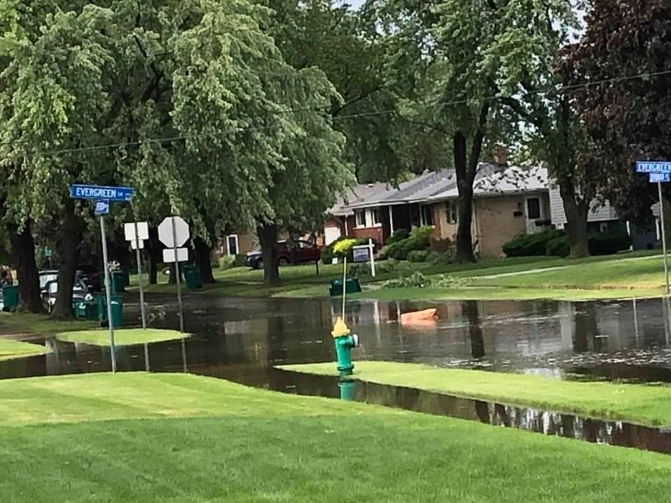
| Wind damage in Dyer. Photo courtesy of Tim Bock. | Additional wind damage in Dyer. Photo courtesy of Nick Bartholomew. | Trees down in Munster. Photo courtesy of Paul Goddard. |
 |
 |
 |
 |
| Flooding in Munster. Photo courtesy of Paul Goddard. | Analyzed 500 mb winds at 8 am showing a strong jet streak rotating into the region. | 850 mb analyzes at 8 am showing increasing moisture just off the surface. | 8 am MLCAPE analysis. Values sufficient for severe storms. |
Local Storm Reports:
PRELIMINARY LOCAL STORM REPORT...SUMMARY
NATIONAL WEATHER SERVICE CHICAGO IL
749 PM CDT WED JUN 10 2020

..TIME...   ...EVENT...      ...CITY LOCATION...     ...LAT.LON...
..DATE...   ....MAG....      ..COUNTY LOCATION..ST.. ...SOURCE....
            ..REMARKS..

1000 AM     FLOOD            1 S HAMMOND             41.57N 87.50W
06/10/2020                   LAKE               IN   DEPT OF HIGHWAYS

            INDIANA DOT REPORTS FLOODING OF SOME LANES
            OF I-80/94 IN HAMMOND. MULTIPLE ADDITIONAL
            REPORTS OF FLOODING FROM OTHER SOURCES IN
            THE VICINITY. UNKNOWN DEPTH. TIME ESTIMATED.

0935 AM     HEAVY RAIN       1 SW DYER               41.49N 87.52W
06/10/2020  M1.21 INCH       LAKE               IN   MESONET

            WEATHERBUG STATION AT KAHLER MIDDLE SCHOOL
            IN DYER REPORTED 1.21 INCHES IN ABOUT 45
            MINUTES.

0935 AM     FLOOD            1 WNW DYER              41.51N 87.52W
06/10/2020                   LAKE               IN   PUBLIC

            PHOTO SHARED VIA SOCIAL MEDIA SHOWING
            FLOODING OF MONTICELLO DRIVE IN DYER.
            UNKNOWN DEPTH.

0910 AM     TSTM WND DMG     1 SW EAST CHICAGO       41.63N 87.47W
06/10/2020                   LAKE               IN   PUBLIC

            PHOTO SHARED VIDEO SOCIAL MEDIA SHOWS
            UPROOTED TREE IN EAST CHICAGO. TIME
            ESTIMATED BY RADAR.

0910 AM     TSTM WND DMG     2 S EAST CHICAGO        41.61N 87.45W
06/10/2020                   LAKE               IN   TRAINED SPOTTER

            PHOTO SHOWS DAMAGE TO POWER LINES ALONG
            MICHIGAN AVENUE (US-20) WEST OF CLINE
            AVENUE. TIME ESTIMATED BY RADAR.

0910 AM     TSTM WND GST     3 SE EAST CHICAGO       41.62N 87.41W
06/10/2020  M69 MPH          LAKE               IN   AWOS

            60KT WIND GUST REPORTED AT 910 AM.

0908 AM     TSTM WND DMG     1 ENE HAMMOND           41.59N 87.47W
06/10/2020                   LAKE               IN   PUBLIC

            REPORT SHARED VIA SOCIAL MEDIA OF DAMAGE TO
            POWER LINES NEAR PURDUE UNIVERSITY CALUMET.
            TIME ESTIMATED BY RADAR.

0908 AM     TSTM WND DMG     2 ENE HAMMOND           41.60N 87.46W
06/10/2020                   LAKE               IN   PUBLIC

            PUBLIC REPORTS OF NUMEROUS TREE LIMBS DOWN
            IN THE HESSVILLE NEIGHBORHOOD OF HAMMOND.

0906 AM     TSTM WND GST     1 N MUNSTER             41.55N 87.51W
06/10/2020  M57 MPH          LAKE               IN   MESONET

            WEATHER BUG STATION AT MUNSTER HIGH SCHOOL
            REPORTS 57 MPH GUST AT 906AM.

0905 AM     TSTM WND DMG     1 ENE MUNSTER           41.55N 87.49W
06/10/2020                   LAKE               IN   TRAINED SPOTTER

            CORRECTION. PHOTO SHOWS LARGE TREE UPROOTED
            NEAR WHITE OAK AVENUE AND FISHER STREET.

0905 AM     TSTM WND DMG     DYER                    41.51N 87.51W
06/10/2020                   LAKE               IN   TRAINED SPOTTER

            PHOTO FROM TRAINED SPOTTER SHOWS DAMAGE TO
            THE ROOF OF A RESIDENTIAL STRUCTURE NEAR
            CALUMET AVENUE AND 213TH STREET. TIME
            ESTIMATED BY RADAR.

0903 AM     HAIL             2 SSW DYER              41.48N 87.52W
06/10/2020  U1.75 INCH       LAKE               IN   PUBLIC

            REPORT SHARED ON SOCIAL MEDIA OF GOLF BALL
            SIZED HAIL IN DYER SOUTH OF US-30.

0810 AM     TSTM WND DMG     4 WNW MANTENO           41.27N 87.91W
06/10/2020                   KANKAKEE           IL   TRAINED SPOTTER

            POWERLINE DAMAGE NEAR 10000N AND 1500W. TIME
            ESTIMATED BY RADAR.

0930 AM     HEAVY RAIN       2 ENE SAUK VILLAGE      41.50N 87.54W
06/10/2020  M2.13 INCH       COOK               IL   TRAINED SPOTTER

            RAINFALL OVER 30 MINUTES.

0903 AM     HAIL             1 SSE LYNWOOD           41.51N 87.53W
06/10/2020  E1.00 INCH       COOK               IL   PUBLIC

            REPORT SHARED ON SOCIAL MEDIA OF HAIL AT
            LEAST QUARTER SIZED, POSSIBLY UP TO GOLFBALL
            SIZED.

0901 AM     HAIL             2 ENE SAUK VILLAGE      41.50N 87.54W
06/10/2020  M2.00 INCH       COOK               IL   TRAINED SPOTTER

            WIND BLOWN HAIL LASTED 5 MINUTES WITH
            SEVERAL HAIL STONES UP TO 2 INCHES,
            RESULTING IN A SHATTERED WIND SHIELD. REPORT
            NEAR SAUK TRAIL BETWEEN SAUK VILLAGE AND
            DYER.

0900 AM     TSTM WND DMG     ENGLEWOOD - CHICAGO     41.78N 87.65W
06/10/2020                   COOK               IL   PUBLIC

            LARGE TREE SNAPPED POWER POLE; 2 CARS UNDER
            MASSIVE BRACHES; POWER OUT.

0845 AM     TSTM WND DMG     2 WSW RICHTON PARK      41.47N 87.76W
06/10/2020                   COOK               IL   TRAINED SPOTTER

            POWER LINES DOWN NEAR STEGER ROAD AND I-57.


&&

$$
Additional Info
 |
Media use of NWS Web News Stories is encouraged! Please acknowledge the NWS as the source of any news information accessed from this site. Additional recaps can be found on the NWS Chicago Past Events Page |
|


