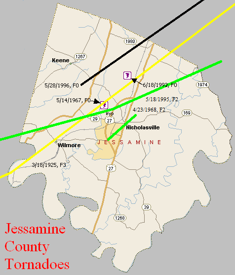
March 18, 1925
Counties: Marion, Washington KY, Mercer, Jessamine, Fayette, Bourbon
F-scale: F3
Deaths: 2
Injuries: 40
Path width: 300 yards
Path length: 60 miles (skipping)
Time: 6:30pm
Notes: What was almost certainly a family of tornadoes moved northeast from western Marion County (according to Grazulis) to 4 miles southwest of Paris in Bourbon County. This project has so far been unable to find any damage in Marion or Jessamine Counties. In Washington County many buildings across the county were leveled. The country home of Judge Case near Springfield was unroofed. The "Negro section" of Jimtown was destroyed, and all 25 houses in Jimtown were razed after the storm. In Springfield 30 people were injured and 2 were killed (the two fatalities may have been from Jimtown). Moving into Mercer County, two barns were lost on the Bond Farm. A barn was damaged and a house unroofed on the Terhune Farm, barns were blown down on the Quartz and Shelton Farms, a house and a barn were lost on the Sanford Farm, and the home of Kye Crossfield at Ebenezer was destroyed. The tornado was 1/4 mile wide in Mercer County. After possibly weakening or lifting in Jessamine County, the tornado slammed into eastern sections of Fayette County with renewed vigor. Trees were blown down on Chilesburg Road, and many trees and fences were torn down on the John E. Madden Farm on Winchester Road about four miles out of Lexington (roughly where Winchester Road meets I-75 today). The tornado reached its peak strength, high-end F3 (possibly F4) over a four-mile stretch of eastern Fayette County. About five and a half miles from Lexington on Briar Hill Road the twister devastated the Kelley Farm. Mrs. Kelley's 40-year-old "Negro hired hand" was blown 300 yards to his death. Nearly every bone in his body was broken. His right hip was dislocated to the point where it was alongside his chest. No trace of his cabin was ever found. The two-story eight-room main residence was "torn from its foundations" and reduced to a pile of rubble. The farm's chickens were stripped of their feathers. According to witnesses, the tornado was "cone-shaped and had a large black cloud at its top, coming out of the west. A pillar of flame shot skyward when the vortex of the twister struck the Kelley residence." Trees and telephone poles were blown down for a mile along Briar Hill Road. The Jonas Weil Farm on Briar Hill Road suffered an unroofed home, two miles of destroyed fence, and 500 felled trees. Moving along to the northeast, the Muir area was next in line (near the intersection of KY 1970 and KY 1973 today). William Johnson's residence on Muir Pike was "piled upon its foundations and partly blown away." The Deaver Farm was damaged, and a 15 pound rock was blown through a wall like a cannonball. Many trees were blown down. Proceeding into Bourbon County, the house of Rodes Donald had two rooms blown away, the Dudley School was moved four feet off its foundation, fifty trees were blown down on the Ewing Farm, and the Spears Farm on Stewart Road was damaged. The tornado then finally began to weaken and it dissipated about four miles shy of Paris.
May 14, 1967
Counties: Jessamine
F-scale: F0
Deaths:
Injuries:
Path width:
Path length:
Time: 7:00am
Noted discrepancies: SPC gives a path length of 1/10 of a mile and a width of 10 yards...NCDC gives nothing for either.
April 23, 1968
Counties: Jessamine
F-scale: F2
Deaths: 0
Injuries: 3
Path width: 75 yards
Path length: 3 miles
Time: 5:34pm
Grazulis narrative: Moved northeast at Nicholasville. A house was shifted off its foundation. Many homes had roof damage, and at least one was unroofed. A barn was picked up and scattered over 60 to 70 acres.
Notes: (This information was discovered on an internal Weather Bureau memo from Charles E. Hardy at WSO Lexington) The violent storm moved from the southwest part of Nicholasville near Shun Pike and reached the center of the city near the police station at Oak and Main. Near Lake Street some trees were felled and some monuments were overturned in Maple Grove Cemetery. An estimated number of 75 to 100 trees were uprooted or blown over. Some roofs on the southwest side of Nicholasville had the tin rolled or twisted toward the northeast. Several windows were broken in an elementary school, which was in session, and flying glass injured one student on their finger. Damage to houses and other buildings was mainly to roofs and windows of the upper floors. One house had its foundation shifted a few feet, and one roof was completely blown off. Power and telephone lines were downed. A car was overturned on Main Street. Mrs. Bloomfield, whose house was in the path of the storm, stated that she heard a noise like a jet airplane. Another witness, Patrolman Swallows of the police department, said he noticed a short appendage looking like a trail of smoke hanging down from the parent cloud and a noise like a freight train was heard. Mr Hammonds, another policeman on duty at the time of the storm, said that he noticed nothing like a funnel, but he observed a violent rotation apparently about a vertical axis in a black ominous looking cloud assoicated with the storm. Two women were injured by flying glass but the injuries were not serious.
Noted discrepancies: SPC and NCDC give 3 injuries, Grazulis gives 6, Storm Data gives 0. SPC and NCDC give a path width of 60 yards, Grazulis 80 yards, Storm Data 75 yards.
June 18, 1992
Counties: Jessamine
F-scale: F0
Deaths:
Injuries:
Path width:
Path length:
Time: 6:01pm
Noted discrepancies: SPC gives a time of 6:01pm, NCDC gives 5:01pm, Storm Data says 7:01pm.
Notes: Storm Data says this tornado struck near Keene.
May 18, 1995
Counties: Mercer, Woodford, Jessamine, Fayette
F-scale: F2
Deaths: 0
Injuries: 30
Path width: 350 yards
Path length: 24 miles
Time: 7:19am-7:46am EDT
Notes from investigation in 2017: In McAfee several homes had uplifted roofs, a chimney was destroyed, and garage doors collapsed. Barns and outbuildings were destroyed. Several cars were blown off US 127, resulting in injuries. The tornado crossed into southern Woodford County just north of Mundys Landing. It damaged or destroyed eight homes with several injuries. In southwest Jessamine County at the intersection of KY 1268 and US 68 seven horses were killed along with extensive barn and fence damage. West Jessamine High School was hit around 7:36am when the tornadic wind speeds were around 145mph. Extensive structural damage was done to the school, amounting to a cost of two million dollars. There were at least 20 injuries, one critical. The tornado struck as students were arriving at school on buses. Eleven buses suffered damage and had their windows blown out. The high school roof was lifted and some top floor exterior walls collapsed. The school's tobacco barn and greenhouse were destroyed and the cattle barn was damaged. The tornado then hit a strip mall and Wal-Mart producing roof uplift and sign damage. Numerous pallets loaded with mulch and topsoil were thrown or shifted several yards. Across the county numerous power poles, barns, and homes sustained damage. The tornado weakened to F1 strength as it moved into the Tates Creek Trailer Park on the Fayette County line. There was complete destruction of roofs and walls of several single and double wide trailers. As the tornado lifted at Coletown several trees fell or were snapped.
Grazulis narrative: A tornado touched down near US 127 and moved northeast. Three houses were destroyed and five were damaged. Barns were blown down along KY 1160 near McAfee. There were also two cars damaged and eight minor injuries. A car was tossed several hundred yards.
Noted discrepancies: Grazulis times this at 6:35am. NCDC gives no beginning or ending locations for this tornado. SPC gives one point, just northeast of KY 390 northwest of Bohon.
May 28, 1996
Counties: Jessamine, Fayette
F-scale: F0
Deaths:
Injuries:
Path width:
Path length:
Time: 6:42pm
Noted discrepancies: None


 Weather Story
 Weather Map
 Local Radar