

Historical St Patrick's Day Weather
Published 2026-03-10
Historical St Patrick's Day weather
| < | November 2025 | |||||
| Sun | Mon | Tue | Wed | Thu | Fri | Sat |
|
26
|
27
|
28
|
29
|
30
|
31
|
1
|
|
2
|
3
|
5
|
6
|
7
|
8
|
|
|
9
|
10
|
11
|
12
|
13
|
14
|
15
|
|
16
|
17
|
18
|
19
|
21
|
22
|
|
|
23
|
24
|
25
|
26
|
27
|
28
|
29
|
|
30
|
1
|
2
|
3
|
4
|
5
|
6
|
Storm summary webpage for Nicholasville Tornado on October 19th 2025.
Latest Drought Information Statement for WFO LMK
Midwest Quarterly Climate Impacts and Outlook
Moderate Drought (D1) was introduced in western and southcentral Kentucky. Abnormally Dry (D0) was also expanded in the areas mentioned above and introduced in northeastern Kentucky.
We had two student scholars work at the LMK office this summer. One was working to develop a national hydroplaning awareness campaign and another was working with rural emergency managers to find out what NWS can do to get the forecast the "last mile" to as many users as possible for hazardous weather.
Past Kentucky Derby, Kentucky Oaks, and Thunder Over Louisville Weather
March 30-31, 2025 Survey Results: Multiple Tornadoes and Wind Damage
Horse Cave NOAA Weather Radio is off the air
Survey Results: EF1 Tornado in Orange County, IN and up to 2 inch hail along the Ohio River
Storm Report Summary from March 15-16, 2025
48-hr rainfall total Ending March 16, 2025 Morning
Spring Hydrologic Outlook 2025
Skywarn training schedule
Join CoCoRaHS!
100th anniversary of the Great Tri-State Tornado
NWR transmitter outages on KIH41 Lexington.
Why NWS forecasts refer to "Washington's Birthday" instead of Presidents Day
The approximate track for a storm damage survey today. Other locations may get surveyed, when we hear of significant reports of damage.
24 hour precipitation ending at 7am EST January 18, 2025
End of RTPs
24-hour rainfall through the morning of December 30, 2024
Peak Wind Gust Map from Dec. 29, 2024 Storm System
20th anniversary of historic winter storm
30th anniversary of WSR-88D at NWS Louisville
Updated winter outlook and December 1-7 outlook
2024 Winter Weather Preparedness Week in Indiana
Climatological frost/freeze information
Adair County, KY Begins Deployment of 16 New Turn Around Don't Drown (TADD) Signs Across the County
Drought Information Statement October 3, 2024
Soliciting Comments on the Discontinuation of the Max/Min Temp & Precip Table (RTP)
Weather Radios for the Deaf and Hard of Hearing in Kentucky
Storm Summary for September 27, 2024
Deaf and Hard of Hearing webpage with videos in ASL and captions.
Autumn Begins at 2:50 am EDT/1:50 am CDT September 23
Changes coming to NWS cold weather headlines
storm summary july 9, 2024
Preliminary tornado survey results from July 9
Lots of Wall Clouds Tuesday from the Remnants of Beryl
20th anniversary of Ohio Valley derecho
Summary of the 4th of July tornadoes that hit the Louisville Metro area and Crandall, IN in Harrison County.
Heat safety and how to spot heat illness
National Water Prediction Service (NWPS) Demo (replaces AHPS)
Regional virtual spotter talk given by NWS Indy on June 12th.
NOAA predicts above-normal 2024 Atlantic hurricane season
Review of severe weather on May 26, 2024
Review of tornadoes on evening of May 7, 2024
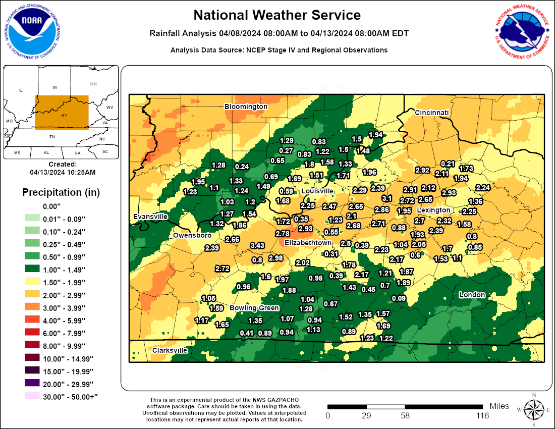
24hr precip ending 7am EDT April 13, 2024
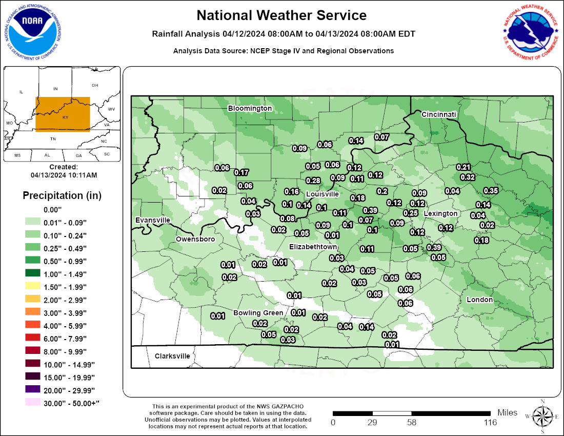
24 Observed Precipitation Ending at 8 AM EDT This Morning
StoryMap Guide on the New NWPS Website (Goes live this Wed 3/27!)
As the earth spins on its axis, producing night and day, it also moves about the sun in an elliptical (elongated circle) orbit that requires about 365 1/4 days to complete. The earth's spin axis is tilted with respect to its orbital plane. This is what causes the seasons.
2023 Shareholders Report
Link to Skywarn training calendar
Drought Information Statement January 18, 2024
30th anniversary of historic January 1994 snow and cold
Drought Information Statement January 4, 2024
CoCoRaHS new year's resolution
A strong storm system moved through the eastern half of the United States from December 9th-11th, 2023. The storm system was supported by a broad upper level trough which deepened and amplified over the central and eastern CONUS on December 9th. At the surface, a cold front over the Mississippi Valley on the morning of the 9th gradually moved eastward across Kentucky and Tennessee.
Looking for feedback on our new National Water Prediction Service (to replace the Advanced Hydrologic Prediction Service)
Fifth National Climate Assessment released
Anniversary of 2018 November ice
Drought Information Statement issued October 27, 2023
The winter weather outlook for the upcoming 2023-2024 winter season
The NWS has officially implemented updated criteria for Winter Storm Warnings for Heavy Snow for the winter season of 2023-2024 over the Contiguous United States. This new criteria serves as the basis for winter storm watches and warnings. The updates were made to improve decision support services, collaboration, and communication.
Our 2023 WRN Ambassador of Excellence: Iroquois Amphitheater
New River Forecast Point at Mammoth Cave starting Oct 31, 2023
Drought Information Statement...Issued Sep 29, 2023
Outlook Tools to Help Diagnose Heat Potential
Spencer County, KY receives Turn Around Don't Drown Road Signs
Updated Atlantic hurricane forecast for the remainder of the season
August 7th, 2023 Tornadoes and Damaging Winds across southern Indiana
Preliminary summary storm report for early morning storms August 7
New Kentucky Mesonet Site on the north side of Lexington
Madison County KY NOAA Weather Radio Return to Service
Madison County, KY receives Turn Around Don't Drown Road Signs
Summer Meteorology Students work at NWS Louisville.
A Summary of Tornadoes and Wind Damage from July 2, 2023
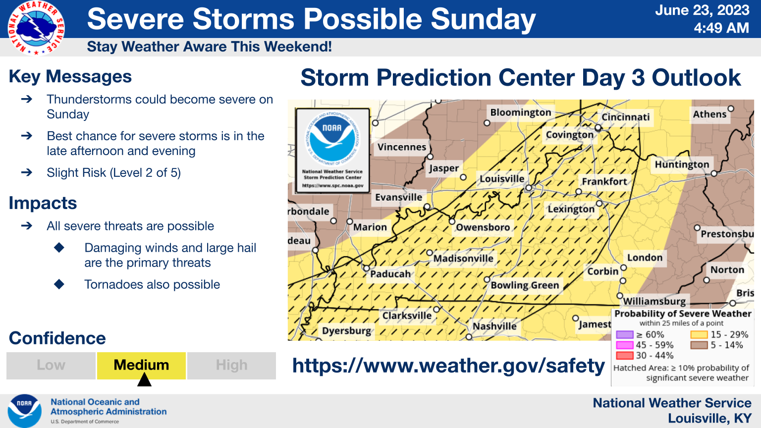
Briefing slide for possible severe weather Sunday June 25, 2023
NWS Louisville attends Tri-agency Meeting and Speaks with USGS Director Dr. Applegate
Event Summary Webpage for May 7th Tornadoes and Straight Line Winds
Understanding Severe Thunderstorm Outlook Categories
Path map of April 5, 2023 tornadoes
49th Anniversary of the Historic Tornado Outbreak Across the Region
Climatological Frost and Freeze Information
5th anniversary of First Day of Spring heavy snow
High wind event of March 3, 2023
2022 NWS Louisville Shareholders Report
5th anniversary of significant Ohio Valley flood
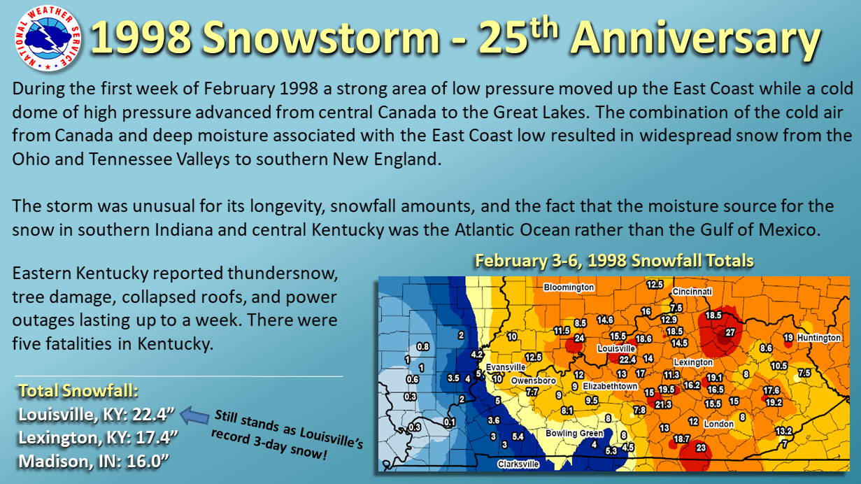
25th anniversary of February 1998 snowstorm
24-hour precipitation ending at 7am EST this morning
24-Hour Precipitation Maps For This Morning
Department of Commerce Gold Medal for Customer Service During Historic Tornado Outbreak
Summary of our nation's weather in 2022
The summary webpage of the Jan 12, 2023 severe weather event across central KY
Safety Information for Tonight's Strong Storm and Flooding Threat
2022 weather year in review for central Kentucky and southern Indiana
Anniversary of New Year's Day 2022 Tornado Outbreak
Volunteer Madison Wallner Talks About Her Project This Fall
Destination forecasts and road conditions
Interactive map of climatological white Christmas probabilities
24-hour Precipitation ending early this morning, December 10, 2022
1 Year Anniversary of the Dec 10-11, 2021 Tornado Outbreak
Kentucky winter awareness week content, created in 2022.
24 Hour Precipitation Ending at 8 AM EDT/7 AM CDT This Morning
Check Out The Peak Wind Gusts From The Region Today
This fact sheet has been developed to help users better understand probabilistic snowfall forecasts.
NWS student researcher Eric Carothers presented this Lexington Airport Temperature Study on 10/20/22. Results show a microclimate at KLEX. Sensor is reading w/in tolerance & monitored daily. Great discussion w/ our Lexington partners.
Most Of The Area Now In Moderate Drought
How Is Your Region Doing With Annual Precipitation So Far?
Register for the 2022 KenTenn Workshop!
Check Out Our 2022 Ambassador Of Excellence!
Rochester River Gauge Datum Changes Coming Oct 6th
Preliminary Local Storm Report Summary
24 hour Rainfall Totals Ending July 26, 2022 at 8AM EDT
Drones Used for Routine Hydrology Surveys
85 mph storm winds in Adair County on May 26, 2022
A macroburst caused significant wind damage in southern Marion County on May 18, 2022 with estimated peak winds of 97 mph. Ping pong ball size hail also fell during the downburst and caused significant siding damage.
These are our planned tornado surveys for today, May 19, 2022.
24-hour Rainfall Ending at 8am EDT May 14
24-hour precipitation ending at 8am EDT May 6
10th anniversary of Louisville area hailstorm
April 13, 2022 Tornadoes & Strong Winds
Summary of Wind Reports from March 30th, 2022
Severe Weather March 18-19, 2022.
Snowfall reports from March 11-12, 2022
10 Year Anniversary: March 2, 2012 Tornado Outbreak
Ekron NOAA Weather Radio transmitter of the air
Summary of severe weather reports from February 17
January 26-28, 2009 Historic Ice Storm and Heavy Snow
Public comments on partial county alerting
Briefing Slides for Jan 19 Winter Weather (Updated 1/19 2PM)
Tornado Survey Results, Including NWS Drone Footage...Updated 1200 PM 12/24
Be prepared for the next time storms threaten
Turn Around Don't Drown Road Signs Awarded to Simpson Co., KY and Clark Co., IN
EF-1 Tornado in Frankfort Caught on Doorbell Camera
Event Summary for December 5-6th, including Tornado in Stamping Ground, KY
Forecasters at regional NWS offices got together virtually to learn about new tools available to help us quickly look through lots of model data to pick out the potential for unusual or extreme events.
Kentucky Winter Weather Awareness Week 2021
Saturday December 4, 2021 is SKYWARN Recognition Day!
48-Hour Precipitation Maps Ending Monday 11/26 at 9:30 AM EST
Routine Weekly Test sent to Louisville NWR transmitter
Partial Lunar Eclipse Expected Early Friday Morning!
2-pager on La Nina in the Midwest and Ohio Valley, November 2021
Indiana Winter Preparedness Week - November 7-13, 2021
Storm Summary for Oct 15, 2021
Simplification of NWS Louisville Flood Products starting on Nov 4th, 2021
Congratulations To This Year's Weather Ready Nation Ambassador of Excellence!
A brief history of the NWS Louisville Office in honor of our 150th Anniversary
Welcome New Meteorologist Chase Graham to Louisville
Change to URL for national climate webpage
48 Hour Precipitation Ending Friday Morning August 20 2021
New Meteorologist Adrian Lopez Lago at Louisville Office
National Hurricane Center Information And Updates
Simplificación de Peligros del SNM: Opciones de MensajerÃa en Lenguaje Sencillo
Changes to Severe Thunderstorm Warnings and Special Weather Statements Coming August 2
Want To Help The NWS With Watch, Warning, and Advisory Products?
10th anniversary of Churchill Downs tornadoes
25th anniversary of F4 tornado south of Louisville
The 1991-2020 normals have been released
Drone Video of the May 3, 2021 Tompkinsville EF-1 Tornado Path
EF-1 Tornado Confirmed in Monroe County May 3, 2021
50th anniversary of killer F4 tornadoes in southern Kentucky
Change to yearly total precipitation at Lexington
Drone footage: ground swirls left in open field by EF-0 Tornado
NWS Louisville will be conducting storm surveys today in Grayson County and LaRue County following yesterday's severe weather event.
Event Summary for February 26 through 28, 2021 Heavy Rain and EF1 Tornado in Clinton County
The National Weather Service office in Louisville will be conducting a storm damage survey on March 2, 2021 in Clinton County, Kentucky.
Recent increase in winter weather severity
Preliminary Snow Depth Maps from Monday Morning 02/01/2021
Tutorial on using the new NWS radar display
2020 NWS Louisville Shareholders Report
Snowfall maps and snowfall reports from January 27, 2021
Preliminary Snow Reports from Jan 16, 2021
Three-Day Rainfall Totals Ending 7 AM January 2, 2021
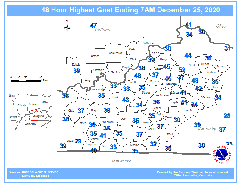
Peak wind gusts from December 23-25, 2020
The weather takes a wintry turn on Christmas Eve with rain changing to a brief wintry mix and then to all snow as temperatures plummet. Minor snow accumulations are possible across central Kentucky and southern Indiana, with the greatest snowfall potential across eastern Kentucky. The Bluegrass Region could see 1-3 inches of snow, with 2-3 inch totals most likely east of I-75.
FAQ and video tutorials for new radar page
Joe Sullivan, Warning Coordination Meteorologist, Retires
December 1-7 marks Winter Awareness Week in Kentucky. Are you prepared?
Two Day Rainfall Totals Ending November 26, 2020 at 7 AM
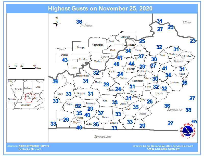
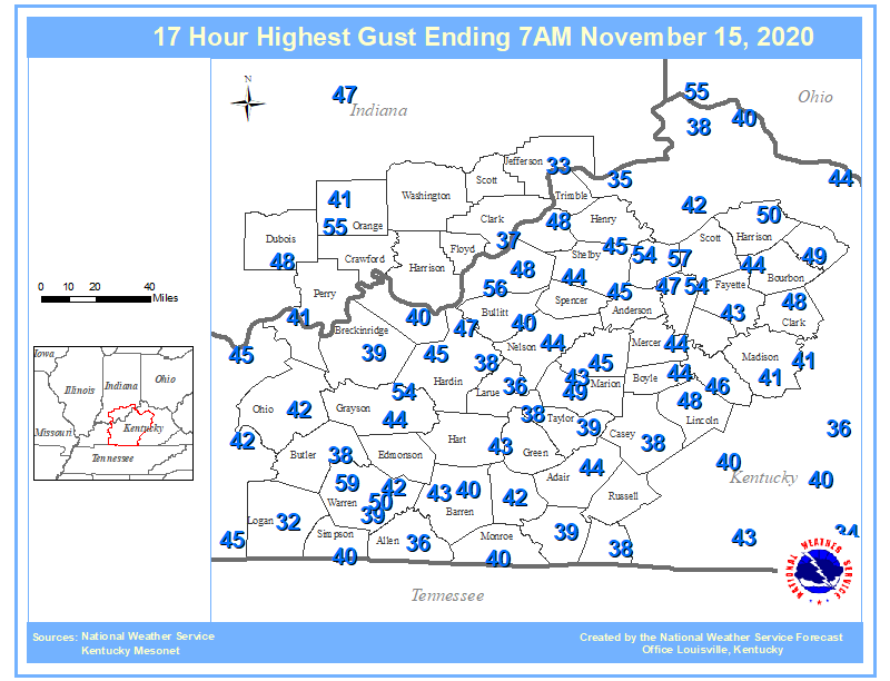
Peak Wind Gusts for Sunday November 15, 2020
Two Day Rainfall Totals Ending October 30, 2020
Winter Weather Observing Training for Indiana CoCoRaHS observers
100th anniversary of Dr. Fujita's birth
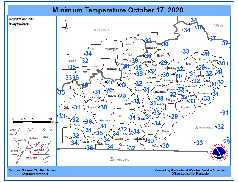
Low temperatures on the morning of October 17, 2020
NWS Louisville Will Begin Using Drones on Surveys.
Flood-Only/High Water Forecasts to begin on the Cumberland River at Burkesville, KY on Oct 29, 2020
2020 Weather Ready Nation Amabassador of Excellence: White Squirrel Weather
120th anniversary of the Great Galveston Hurricane
It takes several times the amount of water in normal flow to raise river levels only slightly.
24 Hour & 3 Day Precipitation Totals Ending the Morning of June 30, 2020
2 Day Precipitation Total Ending 7 AM June 29, 2020
Statewide Air Quality Warning from CHFS
Join us TONIGHT at 7 PM EDT for our "A Day in the Life of the NWS" webinar! Click here to register!
Accumulated rainfall graphics for 5 days worth of rain, ending 7 AM May 20, 2020
25th anniversary of the Nicholasville Tornado
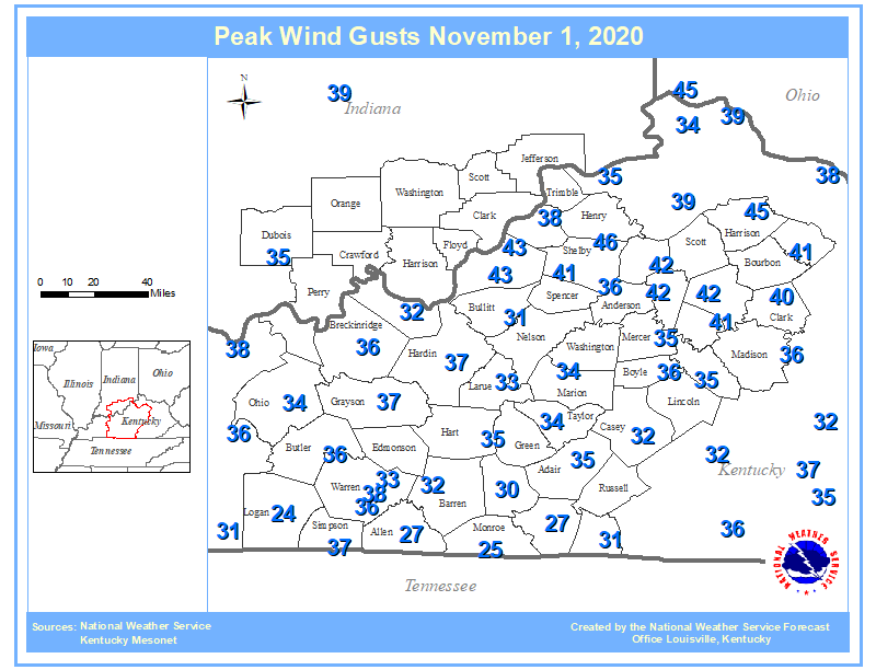
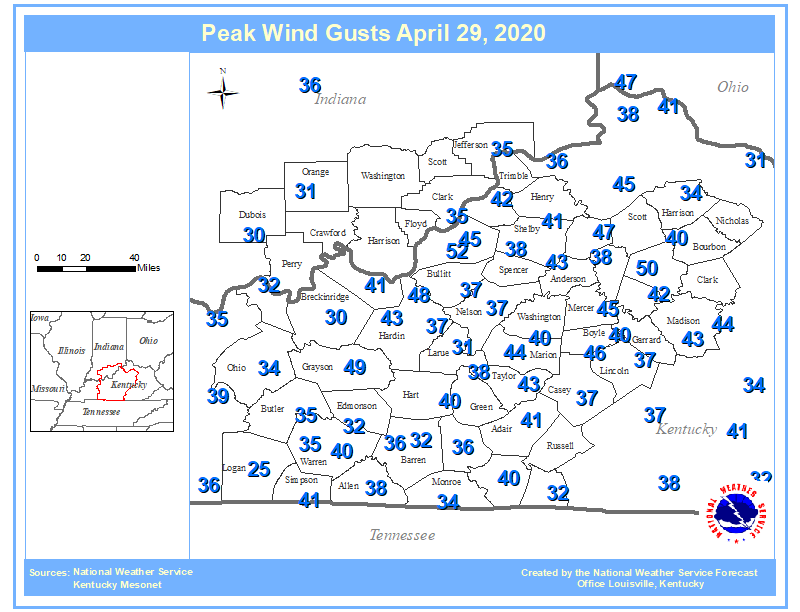
Peak Wind Gusts from Wednesday April 29, 2020
NWS Louisville and Wave 3 To Hold Virtual Spotter Training This Wednesday
Morning low temperature and 24-hour precipitation maps
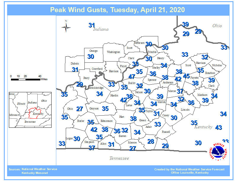
Peak wind gusts across the region for Tuesday April 21, 2020
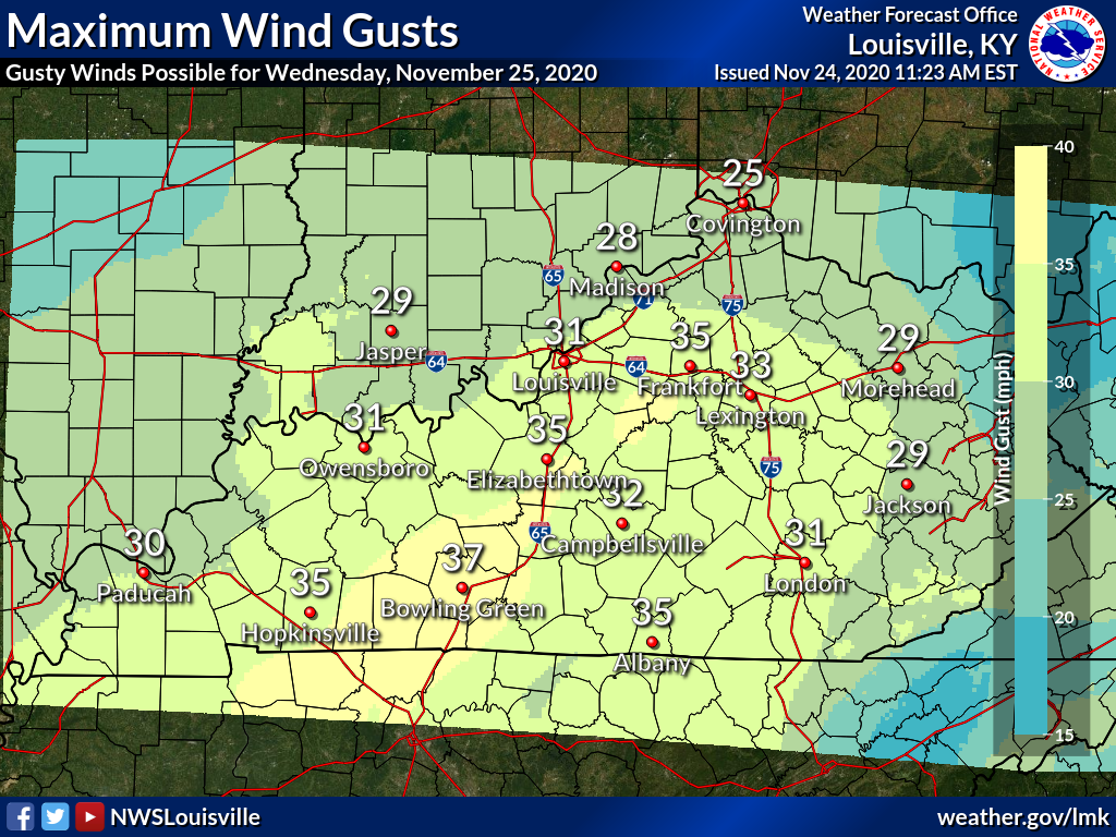
Severe weather is possible tonight across the region. Then very windy conditions are expected Monday.
NWS Storm Survey Team Confirms a tornado in Nelson County and 90 MPH Straight-line Winds in Clark County, IN and Oldham County, KY.
130th anniversary of the 1890 Louisville tornado.
Indiana Severe Weather Preparedness Week 2020
Be Sure To Watch The KET Severe Weather Call In Show Tonight
WarrenAllenCountyTornadoStraightLineWinds
Anniversary of March 2, 2012 Tornado Outbreak (Henryville EF-4)
NWS Louisville's 2019 Shareholders Report
NWS Louisville Visits TRIMARC Operations Center
January 11, 2020 Damaging Wind and Rainfall
2 Day Precipitation Totals ending Sunday Morning 01/12/2020
Highest Wind Gusts From Saturday January 11, 2020
Top 15 local weather events from 2010-2019
Learn Some Tips to be Ready for Winter Weather Driving
25th anniversary of KLVX Doppler radar
NOAA Weather Radio test has been moved from Wednesday to Tuesday
Impact-Based Flash Flood Warnings coming Dec 1st!
One year anniversary of unusual November ice event
Snow Depth Ending 7 AM November 12, 2019
Experimental Probabilistic Snow Forecasts
NWS Louisville Attends Snow Ready Press Conference
The remnants of Tropical Storm Olga packed quite the punch across parts of the Ohio Valley Saturday. A narrow corridor of damaging winds, associated with the core of that system, caused damage and power outages from near Hopkinsville, KY north to Owensboro, KY and Ferdinand, IN. Rainfall ahead of the system helped continue the improvement on the flash drought from September.
NWS Louisville Hosts Hydrology Related Presentations
WKU Hosts NWS Louisville For Professional Development Workshop
NWS Louisville helped with planting at the Parklands as well as with Dare to Care Food Bank, as part of the NWS Week of Service activities nationwide.
Maximum Temperatures September 28, 2019
2019 Weather Ready Nation Ambassador of Excellence: Humana
NWS meteorologists attend the Huntsville National Weather Association meeting last week in Huntsville, AL.
Scenes from this year's KenTenn Weather Workshop on November 16
For the latest Hurricane Dorian information, go to this website...especially if you have any travel plans for the southeast U.S. this holiday weekend!
Three Day Precipitation Ending 28 August 2019
Humana Hosts NWS Louisville for Weather Safety Presentation
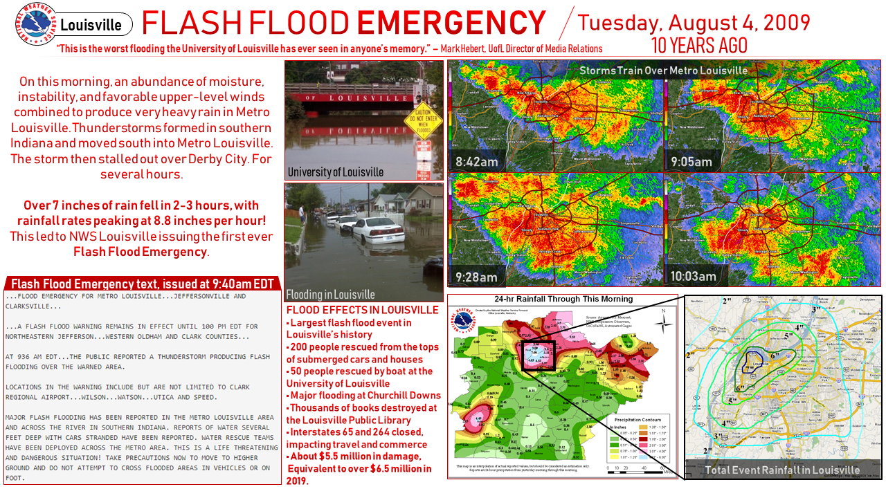
NEW! August 4, 2009 Flash Flood Story Map
10th anniversary of Louisville Flash Flood Emergency
There will be a Total Solar Eclipse down in South America later this afternoon
50th anniversary of the Red Boiling Springs Flood
EF1 Tornadoes in Simpson and Allen Counties June 21
How to get our forecasts in a format tailored for your mobile device.
A severe thunderstorm moving northeast across northern Kentucky produced an EF-1 tornado. The tornado tracked 8.3 miles across Oldham County doing damage mostly to the upper halves of several trees.
Today Marks the 45th Anniversary of the 1974 Super Outbreak
Brief EF0 Tornado in Washington County, Indiana March 14, 2019
March 17-23, 2019 is Severe Weather and Flood Preparedness Week in Indiana
Spring Begins at 5:58pm EDT/4:58pm CDT March 20
Briefing Slides for Severe Weather This Afternoon and Evening (updated 400 AM EST Saturday)
Want To See How We Are Recognizing Our Weather Ready Nation Ambassadors?
This Is Severe Weather Awareness Week in Kentucky
KET Severe Weather Call-In Show Tonight 8 to 9 PM
Two Heavy Rain Events Plus a Windy End to the Weekend
Weekend Rainfall Totals (2/22/19-2/24/19)
12 Hour Highest Wind Gust Ending 8PM February 14, 2019
Flood Threat Next Few Days
Four day Accumulation from 05 February through 08 February 2019
Details of the snow storm that came across the region the evening of Jan. 19, 2019.
10th anniversary of the January 2009 ice storm
These are the peak wind gusts measured during the afternoon and evening hours of Tuesday, January 8, 2019.
24 Hour Highest Gust Ending 7AM January 8, 2019
NWS Damage Survey Team confirms EF-1 Tornado in Harrison County, IN
Expect A Wet, Windy, and Potentially Stormy New Year's Eve
December 8-9, 2018 Ice over Southern Kentucky
12 Hour Peak Wind Gust Ending 7PM December 2, 2018
100th Anniversary of First Official Aviation Weather Forecast
New temperature and precipitation graphs
Strong Gusty Winds and Scattered Snow Showers Today
Unusual November icing in Louisville
An unusual freezing rain event impacted the region.
With the measurable snow Thursday, past similar years would indicate a good chance at a snowy winter.
NWS Damage Survey Team confirms EF-1 Tornado in Hardin County
Rainy Halloween Expected
Why Frost Forms at Temperatures Above Freezing
End of Growing Season and Frost/Freeze Program
Please Take a Survey on Winter Weather Warning Simplification
Is tornado frequency increasing in parts of the U.S.?
Summary of records broken or tied October 2-10, 2018
Recap of the first week of October.
2nd wettest October day on record in Lexington
National Wireless Emergency Alert Test October 3
Autumn Begins at 9:54pm EDT/8:54pm CDT September 22
Up to date Hurricane Florence Information
Four Day Accumulation from 06 September through 10 September
Summary of severe weather on September 8, 2018
Flash Flood Potential This Weekend
NWS Louisville is now accepting applications for its summer 2019 Student Volunteer Program.
Supercell in North Central Tennessee, As Seen By Local Cameras
Louisville Had The 5th Wettest August Of All Time
NWS Louisville at NWA Annual Meeting 2018
One Year Anniversary of the Total Solar Eclipse in Kentucky
Perseid Meteor Shower and Cloud Cover Forecasting
We Need Volunteers to Help Measure Precipitation!
Anti-Crepuscular Rays Monday Morning in South Central Kentucky
Was It a Tornado or Not? Thunderstorm Winds Explained
Damaging Wind, Large Hail, and 4 Confirmed Tornadoes from July 20, 2018
Storm Reports From Friday, Damage Surveys Still Underway
sports safety conference
When we issue any type of warning, we usually do it for a given area. If one were issued and you saw it on a map, could you find your location on that map? Use the information here to help figure that out.
2018 Hurricane Season Outlook and Name List
Record warmth for May continues. The average temperature for May 1-22 is the number one warmest for Louisville and Lexington and number 2 for Bowling Green.
Elizabethtown NOAA Weather Radio Transmitter Maintenance
While there have not been many records, the persistence of above-normal temperatures so far this month has translated to the warmest first half of May on record for Louisville.
The Elizabethtown and Ekron transmitters may briefly go down for preventative maintenance this morning.
Citizen Scientists -- the Power of the Crowd
Indiana Severe Weather and Flood Preparedness Week
Winter Storm Summary for March 11-12, 2018
25th anniversary of the Storm of the Century
NWS Louisville Seeking Students for Summer 2018 Volunteer Program
NWS Louisville speaks at KCJEA Annual Winter Conference
Those attending parties may want to prepare for another round of snow showers this evening.
How to find access to the latest satellite imagery across the Midwest
Preliminary Snowfall Totals for January 15-16, 2018 Winter Storm
As you wake up this morning, please take a moment to report your snow depth. Try and take it away from buildings, in an open field on a grassy surface. Thanks!
Summary of the January 12-13, 2018 Winter Storm
Snow will taper off late, but it will stay cold and windy.
Four long-time NWS staffers retire at the start of 2018
24 Hour Minimum Temperature Ending at 7 AM
Winter Begins at 11:28am EST (10:28am CST) Thursday, December 21
Hydrologist gives talks at elementary school
The Brutal Winter Weather of December 1917 - January 1918
Climatological Cloud Information for the Eclipse
 Weather Story
 Weather Map
 Local Radar