
March 20, 1882
Counties: Fayette
F-scale: F2
Deaths: 0
Injuries: 1
Path width:
Path length:
Time:
Narrative: Hit the northern part of Lexington. Houses were unroofed. Barns and the L&N roundhouse were flattened. The roof was torn off of the Tarr Distillery at 899 Manchester Street. According to the (Lexington) Weekly Press, the roof of "Mr. Sharp's house on the hill" was removed, and two chimneys were destroyed at the home of Mr. Bassett. One person was severely injured, and may have died later.
June 1, 1917
Counties: Fayette
F-scale: F2
Deaths: 0
Injuries: 3
Path width:
Path length:
Time: 10:30am
Narrative: Buildings were unroofed in downtown Lexington and at Sayre College.
March 18, 1925
Counties: Marion, Washington KY, Mercer, Jessamine, Fayette, Bourbon
F-scale: F3
Deaths: 2
Injuries: 40
Path width: 300 yards
Path length: 60 miles (skipping)
Time: 6:30pm
Notes: What was almost certainly a family of tornadoes moved northeast from western Marion County (according to Grazulis) to 4 miles southwest of Paris in Bourbon County. This project has so far been unable to find any damage in Marion or Jessamine Counties. In Washington County many buildings across the county were leveled. The country home of Judge Case near Springfield was unroofed. The "Negro section" of Jimtown was destroyed, and all 25 houses in Jimtown were razed after the storm. In Springfield 30 people were injured and 2 were killed (the two fatalities may have been from Jimtown). Moving into Mercer County, two barns were lost on the Bond Farm. A barn was damaged and a house unroofed on the Terhune Farm, barns were blown down on the Quartz and Shelton Farms, a house and a barn were lost on the Sanford Farm, and the home of Kye Crossfield at Ebenezer was destroyed. The tornado was 1/4 mile wide in Mercer County. After possibly weakening or lifting in Jessamine County, the tornado slammed into eastern sections of Fayette County with renewed vigor. Trees were blown down on Chilesburg Road, and many trees and fences were torn down on the John E. Madden Farm on Winchester Road about four miles out of Lexington (roughly where Winchester Road meets I-75 today). The tornado reached its peak strength, high-end F3 (possibly F4) over a four-mile stretch of eastern Fayette County. About five and a half miles from Lexington on Briar Hill Road the twister devastated the Kelley Farm. Mrs. Kelley's 40-year-old "Negro hired hand" was blown 300 yards to his death. Nearly every bone in his body was broken. His right hip was dislocated to the point where it was alongside his chest. No trace of his cabin was ever found. The two-story eight-room main residence was "torn from its foundations" and reduced to a pile of rubble. The farm's chickens were stripped of their feathers. According to witnesses, the tornado was "cone-shaped and had a large black cloud at its top, coming out of the west. A pillar of flame shot skyward when the vortex of the twister struck the Kelley residence." Trees and telephone poles were blown down for a mile along Briar Hill Road. The Jonas Weil Farm on Briar Hill Road suffered an unroofed home, two miles of destroyed fence, and 500 felled trees. Moving along to the northeast, the Muir area was next in line (near the intersection of KY 1970 and KY 1973 today). William Johnson's residence on Muir Pike was "piled upon its foundations and partly blown away." The Deaver Farm was damaged, and a 15 pound rock was blown through a wall like a cannonball. Many trees were blown down. Proceeding into Bourbon County, the house of Rodes Donald had two rooms blown away, the Dudley School was moved four feet off its foundation, fifty trees were blown down on the Ewing Farm, and the Spears Farm on Stewart Road was damaged. The tornado then finally began to weaken and it dissipated about four miles shy of Paris.
March 24, 1937
Counties: Fayette, Clark KY
F-scale: F4
Deaths: 5
Injuries: 28
Path width: 150 yards
Path length: 15 miles
Time: 5:50pm
Notes: This major tornado touched down in Fayette County between Athens and Boone Creek, probably between Gentry Road and Athens-Boonesboro Road. Only one structure was destroyed in Fayette County, which was a barn on the Scott Farm when the tornado was about 200 yards wide and less than a minute old. The tornado grew in strength very rapidly, and after traveling only about a mile it crossed Boone Creek and completely swept away a house on the Clark County side of the creek. A four-year-old girl in the house was blown 200 yards and survived with a broken leg. The storm continued to the northeast through Becknerville (where the funnel was 400 yards wide), with its sights set on Winchester. The storm roared across Two Mile Pike and into the southern and eastern outskirts of the city. The worst of the storm hit a section variously called, among different sources, "the Patio," "Patio Pike," and "Patio Station," which is believed to be in the vicinity of the intersection of modern-day Patio Street and Hamilton Street along the railroad tracks. Here a 9-year-old boy was partially scalped and suffered a fractured skull. One hundred buildings were leveled and parts of houses were found half a mile away. Only three houses remained standing on the far east side of Winchester. A witness on a high spot on East Broadway witnessed the tornado decimate the Patio/Muddy Creek Pike area around 6pm. The tornado was a "funnel-shaped spiral, light gray at the top and black at the bottom." The tornado continued northeast, crossing Irving Road and Ironworks Road, finally dissipating five miles east of Winchester. It was noted in the local press that the tornado never left the ground along its 15 mile path, and made a "clean sweep" of the earth. It was called the worst storm in the history of Clark County, and probably still is (rivaled only by the April 3, 1974 tornado). Though the tornado missed central Winchester, the city was pummeled by hail up to 4" in diameter (grapefruit sized) that damaged roofs, ripped car tops, and covered the ground like snow. The hailstones had "long icicles" on them. Click here for a map showing the approximate path of the tornado through Winchester.
April 8, 1948
Counties: Fayette
F-scale: F2
Deaths: 1
Injuries: 4
Path width: 200 yards
Path length:
Time: 2:00pm
Narrative: A "bounding-type" tornado destroyed barns and stables at the Keeneland Race Track. A groom was killed. Minimal F2.
July 13, 1956
Counties: Fayette, Bourbon
F-scale: F1
Deaths: 0
Injuries: 0
Path width: 30 yards
Path length: 3 miles
Time: 5:00pm
Grazulis Narrative: Moved northeast from extreme northeast Fayette County, tearing apart four farms. At least one barn was destroyed.
Noted discrepancies: SPC and NCDC list this as an F1...Grazulis calls it an F2. SPC and NCDC give a time of 6:00pm, Storm Data gives 5:00pm, Grazulis says 6:30pm. SPC gives a path length of 1/10 of a mile...NCDC gives nothing...Grazulis gives 3 miles. SPC and Grazulis give a path width of 30 yards...NCDC gives nothing...Storm Data says 38 yards. SPC and NCDC give only a touchdown point (which agrees with Grazulis' touchdown point), but no lift-off point.
March 21, 1962
Counties: Fayette
F-scale: F1
Deaths: 0
Injuries: 0
Path width:
Path length: 1/3 of a mile
Time: 9:00am
Grazulis narrative: At Blueberry Hill, two barns were "blown up and flattened" by a tornado that touched down south of Lexington.
Noted discrepancies: SPC and NCDC list this as an F1, Grazulis calls it an F2. SPC gives a path width of 10 yards, NCDC 30 yards, Grazulis nothing. Grazulis lists it at 10:00am.
April 3, 1974
Counties: Madison, Fayette
F-scale: F2
Deaths:
Injuries: 0
Path width:
Path length:
Time: 6:30pm
Grazulis narrative: Moved northeast near Valley View, destroying buildings in the southeast part of (Fayette County).
Noted discrepancies: Grazulis does not include Madison County. NCDC does not include Fayette County. NCDC gives no endpoint lat/lon. SPC starts the tornado in Madison County just south of Valley View, which is in Madison County near the point where Madison, Jessamine, and Fayette counties meet (but definitely in Madison County). The way the Kentucky River winds through the area, the SPC track takes the tornado from near Valley View in Madison County, into southernmost Lexington in Fayette County, and then back into Madison County. Storm Data mentions only that this tornado "touched down briefly" near where I-75 crosses the Fayette/Madison County line. SPC and NCDC give a path length of 5 miles, Grazulis gives 9 miles. SPC gives a path width of 10 yards, NCDC 30 yards, Grazulis nothing.
October 1, 1977
Counties: Fayette
F-scale: F1
Deaths:
Injuries:
Path width:
Path length:
Time: 8:00am
Noted discrepancies: SPC's beginning lat/lon is in Scott County KY. Cannot plot this tornado without further research.
June 10, 1980
Counties: Fayette
F-scale: F0
Deaths: 0
Injuries: 0
Path width: 30 yards
Path length: 3 miles (skipping)
Time: 4:00pm
Notes: This tornado touched down in Lexington on Patterson Street and skipped to the east-southeast at 35mph, lifting near New Circle Road south of Winchester Road. Numerous trees and power lines were blown down and windows were broken.
July 2, 1980
Counties: Scott KY, Fayette
F-scale: F1
Deaths: 0
Injuries: 0
Path width: 300 yards
Path length: 13 miles (skipping)
Time: 6:55pm
Noted discrepancies: SPC gives a path width of 10 yards, NCDC 30 yards, Storm Data 300 yards. The details concerning this tornado are somewhat murky, but it appears that it touched down southwest of Georgetown where it damaged a greenhouse, and skipped to the east into far northern Fayette County. The Lexington Leader mentions the tornado north of the city but doesn't say anything about any damage. Rather, the paper instead describes damage in Lexington in a southwest-northeast path from Collier Court through Balmoral Court to the intersection of Bryanwood Parkway and Bellcastle Road. It's possible that this was a very small weak tornado, but knowing that for certain is virtually impossible this far after the event. The newspaper also mentions light damage on Nantucket Drive and Melbourne Way in the southwest part of the city, and a tree that was blown down somewhere on Emerson Drive.
March 10, 1986
Counties: Fayette
F-scale: F2
Deaths: 0
Injuries: 20
Path width: 100 yards
Path length: 3 1/2 miles
Time: 4:50pm
Notes: This was one of the worst tornadoes ever to strike Lexington. The tornado began in the vicinity of Tates Creek Road and Man O War Boulevard. A barn was destroyed near the intersection of Wilson Downing Road and Tates Creek Road. The twister traveled to the northeast, heavily damaging Gainesway, Southeastern Hills, and many neighborhoods along Man O War Boulevard before lifting at Richmond Road across the street from Saint Joseph East Hospital. Park Hills Shopping Center was damaged, and Pimlico Parkway and Mammoth Drive were badly hit. Roofs were torn off at Ak-Sar-Ben Park. Overall, 845 homes were damaged, and 200 of them near-F3. Heavy damage was seen on Green River Court and at 3576 Pimlico Parkway. The roof at 3245 Mammoth Drive flew into the Park Hills Shopping Center, 1240 Ascot Park was badly damaged, and the houses at 3576 Bold Bidder and 1248 Ak-Sar-Ben Park were destroyed. Somewhat lighter damage was noted on Personality Court, Sundart Drive, Centre Parkway, and River Park Drive in Gainesway. A man at 3576 Bold Bidder broke his neck when a brick wall collapsed on him. About 150 families required emergency shelter. Originally, the head of the National Weather Service in Lexington, Jim Speray, claimed that the damage was done by a downburst rather than by a tornado, with winds of 100 to 200 mph. He later changed his ruling to an F2 tornado. Tornado expert Dr. Ted Fujita (or possibly students of his) surveyed the damage. By coincidence, this was the date of the annual statewide tornado drill test. Jim Barnes of 1448 Canonero Drive said he was grilling steaks in his driveway. "When I flipped one of the steaks and it didn't come back down, I knew it was time to go inside." Click here for a map of the tornado's path and damage pictures. Streets that suffered damage (other than those listed above): Atokad Park, Aztec Circle, Big Ben Court, Carlsbad Court, Carriage Lane, Custer Drive, Custer Lake Court, Dale Drive, East Hills Drive, Glacier Court, Golden Gate Park, Mount Rainier Drive, Packanack Court, Personality Court, Pipestone Court, Rocky Mount Court, Stephen Foster Drive, Shoal Lake Drive, Squires Circle, Squires Road, Tates Brook Drive, Travis Court, Tuscaloosa Lane, Woodview Drive, and Yosemite Circle.
May 18, 1995
Counties: Mercer, Woodford, Jessamine, Fayette
F-scale: F2
Deaths: 0
Injuries: 30
Path width: 350 yards
Path length: 24 miles
Time: 7:19am-7:46am EDT
Notes from investigation in 2017: In McAfee several homes had uplifted roofs, a chimney was destroyed, and garage doors collapsed. Barns and outbuildings were destroyed. Several cars were blown off US 127, resulting in injuries. The tornado crossed into southern Woodford County just north of Mundys Landing. It damaged or destroyed eight homes with several injuries. In southwest Jessamine County at the intersection of KY 1268 and US 68 seven horses were killed along with extensive barn and fence damage. West Jessamine High School was hit around 7:36am when the tornadic wind speeds were around 145mph. Extensive structural damage was done to the school, amounting to a cost of two million dollars. There were at least 20 injuries, one critical. The tornado struck as students were arriving at school on buses. Eleven buses suffered damage and had their windows blown out. The high school roof was lifted and some top floor exterior walls collapsed. The school's tobacco barn and greenhouse were destroyed and the cattle barn was damaged. The tornado then hit a strip mall and Wal-Mart producing roof uplift and sign damage. Numerous pallets loaded with mulch and topsoil were thrown or shifted several yards. Across the county numerous power poles, barns, and homes sustained damage. The tornado weakened to F1 strength as it moved into the Tates Creek Trailer Park on the Fayette County line. There was complete destruction of roofs and walls of several single and double wide trailers. As the tornado lifted at Coletown several trees fell or were snapped.
Grazulis narrative: A tornado touched down near US 127 and moved northeast. Three houses were destroyed and five were damaged. Barns were blown down along KY 1160 near McAfee. There were also two cars damaged and eight minor injuries. A car was tossed several hundred yards.
Noted discrepancies: Grazulis times this at 6:35am. NCDC gives no beginning or ending locations for this tornado. SPC gives one point, just northeast of KY 390 northwest of Bohon.
May 28, 1996
Counties: Jessamine, Fayette
F-scale: F0
Deaths:
Injuries:
Path width:
Path length:
Time: 6:42pm
Noted discrepancies: None
May 27, 2004
Counties: Fayette
F-scale: F3
Deaths:
Injuries: 6
Path width:
Path length:
Time: 9:15pm
Notes: Storm Data takes this tornado from 4.7 miles northeast of the Lexington airport to one and a half miles southeast of Greendale. It touched down on Buck Lane, struck KY 1978, crossed Georgetown Road, and struck near Citation Boulevard.


 Weather Story
 Weather Map
 Local Radar
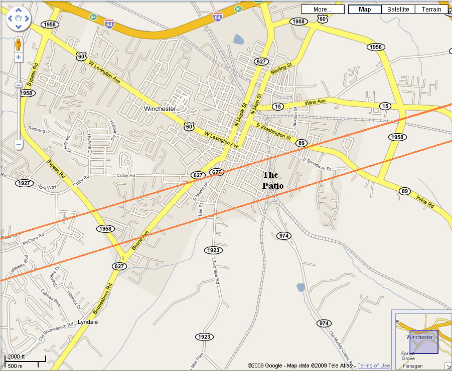