
April 28, 1887
Counties: Clark KY
F-scale: F2
Deaths:
Injuries:
Path width:
Path length:
Time: 5:00pm
Narrative: Homes and barns were destroyed at Wade's Mill.
March 24, 1937
Counties: Fayette, Clark KY
F-scale: F4
Deaths: 5
Injuries: 28
Path width: 150 yards
Path length: 15 miles
Time: 5:50pm
Notes: This major tornado touched down in Fayette County between Athens and Boone Creek, probably between Gentry Road and Athens-Boonesboro Road. Only one structure was destroyed in Fayette County, which was a barn on the Scott Farm when the tornado was about 200 yards wide and less than a minute old. The tornado grew in strength very rapidly, and after traveling only about a mile it crossed Boone Creek and completely swept away a house on the Clark County side of the creek. A four-year-old girl in the house was blown 200 yards and survived with a broken leg. The storm continued to the northeast through Becknerville (where the funnel was 400 yards wide), with its sights set on Winchester. The storm roared across Two Mile Pike and into the southern and eastern outskirts of the city. The worst of the storm hit a section variously called, among different sources, "the Patio," "Patio Pike," and "Patio Station," which is believed to be in the vicinity of the intersection of modern-day Patio Street and Hamilton Street along the railroad tracks. Here a 9-year-old boy was partially scalped and suffered a fractured skull. One hundred buildings were leveled and parts of houses were found half a mile away. Only three houses remained standing on the far east side of Winchester. A witness on a high spot on East Broadway witnessed the tornado decimate the Patio/Muddy Creek Pike area around 6pm. The tornado was a "funnel-shaped spiral, light gray at the top and black at the bottom." The tornado continued northeast, crossing Irving Road and Ironworks Road, finally dissipating five miles east of Winchester. It was noted in the local press that the tornado never left the ground along its 15 mile path, and made a "clean sweep" of the earth. It was called the worst storm in the history of Clark County, and probably still is (rivaled only by the April 3, 1974 tornado). Though the tornado missed central Winchester, the city was pummeled by hail up to 4" in diameter (grapefruit sized) that damaged roofs, ripped car tops, and covered the ground like snow. The hailstones had "long icicles" on them. Click here for a map showing the approximate path of the tornado through Winchester.
April 3, 1974
Counties: Garrard, Madison, Clark KY
F-scale: F4
Deaths: 7
Injuries:
Path width: 300 yards
Path length:
Time: 6:20pm
Grazulis narrative: Moved northeast from near Hackley and Cottonburg, passing just north of Richmond, and lifting east of Mount Sterling. Thirty homes were destroyed, with F4 damage and deaths in southwest Madison County, mostly near Richmond. About 100 people were left homeless in Clark County.
Noted discrepancies: SPC, Storm Data, and NCDC give 28 injuries, Grazulis give 27. SPC and NCDC give a path length of 32 miles, Grazulis give 35 miles, Storm Data 22 miles. SPC gives a path width of 10 yards, NCDC 30 yards, Storm Data 133 yards, Grazulis 300 yards. Grazulis takes this tornado into Montgomery County, ending it east of Mount Sterling. SPC and NCDC end the tornado in Clark County east of Mount Zion. Grazulis places this tornado at 7:20pm.
Notes: Grazulis' path width is probably the most correct. Storm Data begins this tornado at Cottonburg, moving it to two miles north of Whitehall and beyond. According to the Garrard County weekly Central Herald, there were seven injuries in Garrard County, which are not accounted for at the NCDC webpage (it lists zero injuries for the Garrard County portion of this tornado). Grazulis doesn't many any specific locations of the injuries he reported.
March 16, 1982
Counties: Clark KY (to Powell)
F-scale: F2
Deaths: 0
Injuries: 2
Path width: 400 yards
Path length: 8 miles
Time: 12:45pm
Grazulis narrative: Moved east from near Trapp, across Hidden Valley and Virden Ridge to the Black Creek area. Four homes, four trailers, and many outbuildings were destroyed.
Noted discrepancies: None
June 16, 1982
Counties: Clark KY
F-scale: F2
Deaths: 0
Injuries: 4
Path width: 30 yards
Path length: 12 miles
Time: 11:00am
Grazulis narrative: A nursing home, gas station, and trailers were wrecked near Winchester.
Noted discrepancies: None
August 11, 1983
Counties: Clark KY
F-scale: F0
Deaths:
Injuries:
Path width:
Path length:
Time: 2:50pm
Noted discrepancies: Storm Data says this storm struck on Irvine Road. Mapped as best as possible, since lat/lon given was just off of Irvine Road. In appears to have struck in or very near Winchester, so additional research may help to pinpoint its exact location.
February 6, 2008
Counties: Clark KY
EF-scale: EF0
Deaths: 0
Injuries: 0
Path width: 125 yards
Path length: 0.9 miles
Time: 1:51am to 1:52am EST
Notes: This quick tornado destroyed two barns and caused substantial damage to three others. A house was damaged, and a corn crib was destroyed. Many trees were uprooted and a few were snapped.


 Weather Story
 Weather Map
 Local Radar
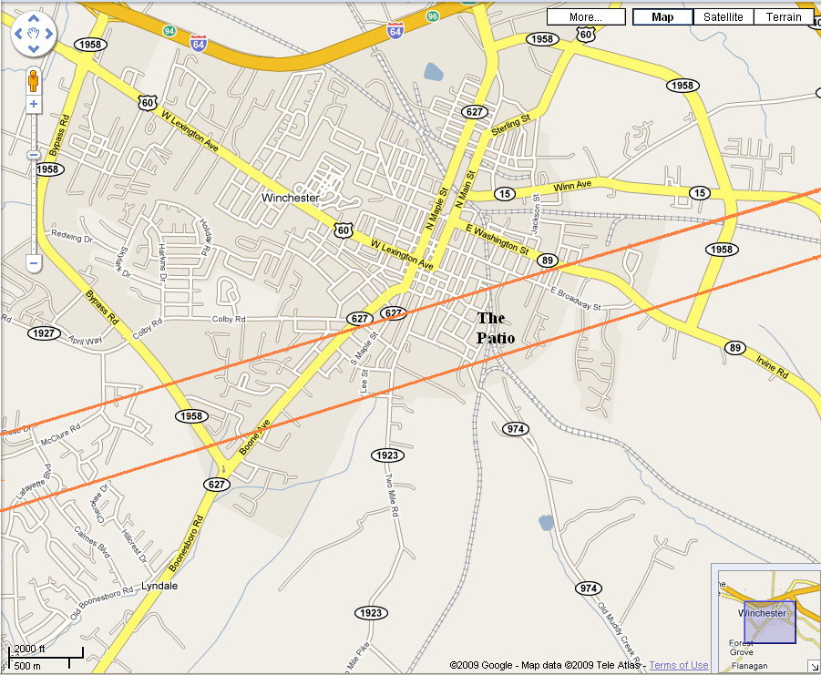