

|
Floods are a force of nature that no one can prevent or contain, which is a well known fact for the residents of central Kentucky and southern Indiana. Floods have been ravaging settlers in the Ohio and Tennessee valleys since they arrived. In an effort to celebrate, remember, and respect our floods, we at the Louisville National Weather Service Forecast Office have made an attempt to gather the ten most important flood events to have struck this region in recorded history into one list. We present that list here. It is understood that, as with any list of extremes, there will be differences of opinion on which events are more or less significant than others. In organizing this list we endeavored to consider several factors, including number of fatalities, geographical area affected, monetary amount of damage, and singularity. If you wish to express your feelings about this list, or if you have personal stories you'd like to share, please e-mail us at nws.louisville@noaa.gov. Please let us know if we may include your comments or experience here on this page. |
|
1. Great Flood |
|
January - February, 1937 |
|
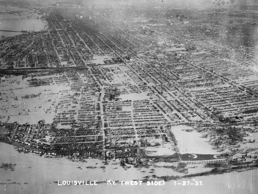
The Ohio River overtakes Louisville |
|
January 1937 surpassed all prior floods during the previous 175 years of modern occupancy of the Ohio River Valley, and geological evidence suggests the 1937 flood outdid any previous flood. The flood was not only the worst ever on the Ohio River in Louisville but also the topped the record charts on the Salt River in Shepherdsville, the Rolling Fork river in Boston, and the Rough River in Dundee, while also causing major flooding in Bowling Green on the Barren River, in Munfordville on the Green River, and in Frankfort on the Kentucky River. However the flood was without a doubt the worst in Louisville where the Ohio crested on January 27 and was marked at an astonishing 85.44 ft. Seventy percent of Louisville was submerged, forcing 175,000 residents to evacuate. Ninety percent of Jeffersonville, Indiana, was flooded. One contemporary source estimated that damage was done to the tune of $250,000,000 (1937 dollars)...that's over $3.3 billion in current dollars!! Photo: Courier-Journal |
|
2. A New Record Rain for Kentucky |
|
March, 1997 |
|
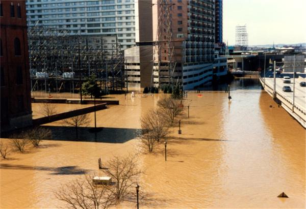
Downtown Louisville becomes part of the Ohio River |
|
In the Louisville metro area about $200,000,000 in damage was attributed to the flooding, with 50,000 homes affected. The crest of the river was reached on March 7 and hit 70.47 ft. Interstates 64 and 65 were closed. 92 counties in Kentucky and 14 counties in southern Indiana were declared disaster areas. Tens of thousands of people were evacuated from their homes, with total damage across the region around $400,000,000. Record flood stages were also attained at Paris on Stoner Creek, Cynthiana on the South Fork Licking River, Blue Lick Springs on the Licking River, and Boston on the Rolling Fork Salt River. Seven people in central Kentucky lost their lives due to the flooding. A record 10.50" of rain fell in 24 hours at the National Weather Service office in Louisville. That record would be broken in 2023. Photo: Judy Webber |
|
3. The Flood Returns |
|
March, 1945 |
|
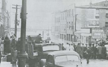
Onlookers observe the rising Ohio River on 4th Street near Main Street of Louisville |
|
This was the second highest flood peak on the Ohio River in Louisville’s history. The flood was due to unusually heavy rains in late February and early March. With that the river rose to 19.1 feet over flood stage and the river crested on March 9 at 74.40 ft. In response to the 1937 flood which had just occurred 8 years prior the people in Louisville built a sand bag dike on March 4th and 5th to try and contain the river, but the Ohio River was not to be contained. Late on March 5 the river was flowing over the dike and caused in the Louisville area approximately 50,000 citizens to evacuate from their homes and caused total flood damage of around $2,600,000. |
|
4. Great Winter Flood |
|
December, 1978 |
|
Frankfort Cut Off |
|
The flood that struck Frankfort in December of that year was the biggest the state’s Capitol had ever seen. On the 10th is when the Kentucky River reached its peak. The river crested at a record 48.47 ft -- a full foot over the crest of the Great Flood of 1937. It was on the 10th that more than half of downtown Frankfort was flooded, forcing around 1,000 people to flee from their homes. This almost completely cut off the state Capitol from the rest of the state. However, the Kentucky River was not the only river to be flooded that December. The Salt River in Shepherdsville, South Fork Licking River in Cynthiana, Rolling Fork in Boston, and Green River in Munfordville all had a flood for the record books. Photos: kydgi.ky.gov |
|
5. Record January Rainfall |
|
January, 1913 |
| Early on in the year unusually great amounts of rain were seen across the state. For January, Kentucky’s total average rainfall amounts reached 11.41 inches, three times the normal average amount. The heavy rains caused every major river and stream in Kentucky to flood. The U.S. Weather Bureau described the lowland areas of the state as being "vast inland seas". In Bowling Green on the Barren River flood waters reached the highest crest ever seen in the area of 52.08 ft on January 8 and in Munfordville on the Green River the second highest crest ever of 54 ft was seen on New Year's Day. |
|
6. 24 Hours of Rain |
|
March, 1964 |
| The March 1964 flood was due to two heavy periods of rainfall. The first period of rainfall was no different than any other heavy March rainfall event; however the second period of rainfall was 6.97 inches in 24 hours which was the greatest 24 hour period of rainfall that had ever been recorded in the Louisville area up until that time. Combined rainfall of each storm was 12 inches which caused the Ohio River to raise a record of 4.7 feet in 12 hours and a total of 8.4 feet in 24 hours, and worst of all this occurred after the Ohio River was already flooded. Finally, the Ohio River crested at 73.46 ft on March 13. This heavy rainfall event also caused record flooding in Shepherdsville on the Salt River, in Cynthiana on the South Fork Licking River, in Frankfort on the Kentucky River, in Boston on the Rolling Fork River, and in Fredericksburg, Indiana on the Blue River. |
|
7. Widespread Flooding |
|
February, 1989 |
|
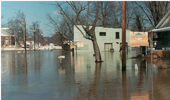
Lebanon Junction Submerged |
|
This flood event was very widespread causing an estimated $18.7 million in overall damage to the Commonwealth of Kentucky. Most of the damage was seen in Frankfort from the Kentucky River with a crest of 44.17 ft on February 16 and in Boston from the Rolling Fork River a crest of 52.62 ft was reached on February 17. Heavy flooding was also seen in Dundee on the Rough River and in Cynthiana on the South Fork Licking. Three people lost their lives due to the flood and a total of 45 counties were declared a Presidential Disaster Area with around 2,100 people having to evacuate their homes. |
|
8. 1/5th of Louisville Submerged |
|
February, 1883 |
|
For the latter part of January and early part of February heavy rains poured down over the Ohio River Valley causing the Ohio River to swell out of its banks. First the flooding occurred in Cincinnati and further east on the Ohio and even the Kentucky River in Frankfort felt the force of the heavy rains when it reached its highest crest to date at 42.10 ft on February 1. However the effects of the heavy rains finally moved down the Ohio River and reached Louisville. The high flood waters caused cut-offs to burst and river water to pour over embankments in one part of the city. This instantaneously submerged nearly 1/5th of the city of Louisville without warning and displaced 7,000 to 8,000 people. People that entered their homes in the day on dry land woke up to water reaching their second story. Total property loss from the incident at the time was estimated to be $300,000. However the water was not done rising until the 16th where it peaked out at 72.20ft, the highest crest to date. |
|
9. Torrential Rain in Kentucky |
|
May 1-2, 2010 |
|
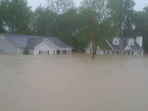
Simpson County. Photo: Alicia Bingham |
|
Strengthening low pressure moving slowly from Texas to Michigan brought copious amounts of Gulf moisture northward that resulted in historic rainfall across the Ohio and Tennessee Valleys. Though the flooding was worse in Tennessee, parts of southern Kentucky were assaulted with 8 to 10 inches of rain. Bowling Green, Marrowbone, Bradfordsville, Richmond, and Albany all set new records for two-day rainfall amounts. Stoner Creek at Paris and the Kentucky River at High Bridge attained their 3rd highest crests on record. The Green River at Rochester stayed above flood stage for two weeks following the rain. Damage totaled more than $30,000,000 and there were five fatalities in central Kentucky. See our special page dedicated to the event. |
|
10. Heavy February Rains |
|
February, 1884 |
|
For the month of February in 1884, nearly the entire country was above average for precipitation. Heavy rains over the Ohio River Valley created major problems along the Ohio River. In Louisville the Ohio River crested at 74.40 ft on the 16th of February which was the worst flood to date. The flood was very long standing and the river was above the danger point from the 4th to the 25th of February. In Louisville property damage was estimated to be $100,000 and it left 6,000 Louisville residents homeless. |


 Weather Story
 Weather Map
 Local Radar