TOP TEN HAIL EVENTS IN THE Louisville CWA

|
As part of a continuing effort to remember, celebrate and learn from our amazing weather, the National Weather Service in Louisville has compiled a list of several "Top 10" events for the County Warning Area. Here we present the list of the top 10 hail events to have ever occured in central Kentucky and southern Indiana. It should be noted that this list applies to central Kentucky and southern Indiana only; countless numbers of deadly hail events not recorded here have occurred across the United States and world as well. Even within a specific region, it can be difficult to condense decades of hail events into merely ten. These events were considered and ranked according to number and severity of injuries, number of fatalities, cost of damages, and the size of the hail reported. If you wish to express your feelings about this list, or if you have personal stories or photos you'd like to share, please e-mail us at w-lmk.webmaster@noaa.gov. Please let us know if we may include your comments or experiences here on this page. |
|
1. Bowling Green Hailstorm April 16, 1998 |
|
Hail and Flooding at Western Kentucky University Photos from https://www.drj.com/articles/wint99/ball.htm |
|
During the mid-afternoon hours a huge supercell thunderstorm moved from northern Logan County through central parts of Warren, Barren and Metcalfe counties and then into western Adair County. An impressive swath of very large hail accompanied the storm across Logan and Warren counties. Many places along the route of the storm reported baseball size hail. Bowling Green was particularly devastated by the storm with incredible damage to all area car lots, all police cars, many homes, and Western Kentucky University. Every car dealership and rent-a-car lot had all of their cars totaled. In all, 8,300 homes, 900 mobile homes, 4,000 vehicles, 37 businesses, and 14 apartment buildings sustained major damage. Minor damage was reported to 1,300 homes, 6,000 vehicles, 42 businesses, and 4 churches. Most of this damage was attributed to the hail as opposed to the tornado that passed just to the south of Bowling Green. In fact the total damage attributed to hail was estimated at more than half a billion dollars. Several people also received minor injuries from being struck by the hail. The hail ranged from golf ball to baseball size and on average measured 2.5 inches in diameter.
|
|
2. CWA-Wide Hail Event May 1, 2002 |
|
Photo from https://chasing-storms.com/large_hail.jpg and https://llnw.image.cbslocal.com/0/2007/04/14/320x240/images_sizedimage_103220333.jpg |
|
Severe thunderstorms producing baseball-size hail or larger moved across Kentucky and southern Indiana, inluding Nelson, Hardin, Bullitt, Washington, Marion, Casey, Lincoln, Pulaski, Rockcastle, Laurel, Pike (IN), Dubois (IN), Perry (IN), Harrison (IN), Washington (IN), and Scott (IN) counties. A large swath of golfball to softball size hail pounded much of central Kentucky causing considerable damage to numerous homes and vehicles. Hail was the cause of three injuries in Springfield, KY (Washington Co.), as well as damage to many homes and vehicles. Softball-size hail was reported in Nelson, Marion, Lincoln, and Pulaski counties. The large and widespread hail resulted in $40 million of property damage and $4 million of crop damage in Kentucky There was large hail across much of South Central Indiana, including widespread damage to vehicles and structures in the Salem area. Area businesses also had window and roof damage due to thunderstorm winds. Other parts of South Central Indiana had damage in the form of downed trees and power lines. Baseball-size hail was reported in Harrison County, while much of the hail across the rest of South Central Indiana was around golf ball-size. This hailstorm resulted in $75,000 worth of damage in south central Indiana. |
|
3. Summer Shade November 22, 1967 |
||||||||||||||||||||||||||||
|
Chart from https://www.crh.noaa.gov/riw/severe/hailwindchart.php Hail Diameter Size Reference Chart (Red indicates Severe Weather Criteria)
|
||||||||||||||||||||||||||||
|
On November 22, 1967, the record hail event in the state of Kentucky occurred near Summer Shade in Metcalfe County. The hailstorm produced marble-size hail that accumulated to depths ranging from 3-6 inches. The "marble-size" description of this hail can be translated to a diameter of a half-inch. |
|
4. May 18, 1995 |
 |
| From Pike County to Calloway County, thunderstorms including damaging hail ranged all over the state on May 18, 1995. A total of 38 hail events were reported on this day, with damages totaling around $745,000. The largest hail was baseball size hail reported in Barren County. Most of the damage was located in Barren and Warren counties, with the total damage estimate in those two counties alone at $515,000. Baseball size hail fell twice in Glasgow, KY, the two events separated by an hour and a half. Numerous roofs and automobiles were damaged in Glasgow. Numerous reports of golfball size hail came from all across Warren County. The baseball size hail across the state damaged cars, windows, and siding. Extensive damage was done to one particular greenhouse in Trigg County. |
 |
|
5. Pre-Derby Hailstorm May 3, 1996 |
|
|
Less than 24 hours before Grindstone pounded out a victory in the 122nd Kentucky Derby in Louisville, Jefferson County was pounded with at least baseball size hail. Louisville and surrounding areas in Jefferson County were hit with $20 million worth of property damage from the hail. Hail from golf ball to baseball size totaled numerous cars across various parts of Louisville including Churchill Downs, Louisville International Airport, Highview, Fern Creek, Okolona, Jeffersontown, Camp Taylor, and Hikes Point. 3 rent-a-car lots in the vicinity of the International Airport were totaled. Baseball size hail at Jeffersontown, Fern Creek, Highview, and Camp Taylor accumulated to 8 inches. Accumulations were also substantial along the Gene Snyder Freeway just south of Fern Creek. The hail path was approximately 5 miles wide and went all the way through the county. Several insurance companies had over 100 claims due to car and home damage. Most of the home damage was to shingles, siding, and windows.
|
|
6. Warren and Marion-Washington Hailstorm May 14, 1995 |
|
Typical hailstone growth path through a thunderstorm cloud. Hailstones add most of their mass during updrafts. |
|
On May 14, 1995, a severe thunderstorm in Marion County produced baseball size hail. Hundreds of cars and homes were damaged by the 2.75 inch hail; the damage total eventually piled up to $5 million. In Warren County on this date, there were two separate hail events, both reported as golfball size hail. The reports came from Bowling Green and Rich Pond. The damage total in Warren County ran to around $150,000. Also, the public reported large amounts of window and car damage in Washington County. The golfball size hail here caused about $50,000 worth of damage. |
|
7. Woodford County Hailstorm August 27, 1996 |
|
Woodford County sustained major crop damage by golfball size hail on August 27, 1996. The 1.75 inch hail damaged 100 acres of tobacco, causing $500,000 in crop damage.
Hail does a great deal of damage to crops, often as much as hundreds of millions dollars in the U.S. and Canada each year. Even small hailstones can destroy crops, slicing plants to pieces in just a few minutes. |
|
8. Doe Valley Estates Hail Event March 29, 2002 |
   www.worsleyschool.net www.worsleyschool.netHailstones can be tiny pellets, or large stones, which sometimes are quite irregular in shape. |
| Roofs were destroyed, siding on homes were destroyed, windows were shattered, gutters and vehicles were dented. The gound was covered by golfball size hail. This was the description for the hailstorm that occurred on March 29, 2002 at Doe Vallley Estates in Meade County. The golfball size hail caused $100,000 worth of property damage. |
|
9. Breckinridge County Hailstorm May 23, 2000 |
| Hail moved through Hardinsburg in Breckinridge County on May 23, 2000. Cars were damaged by baseball size hail, that caused $15,000 worth of property damage. |
|
10. Valley Station Hail Event May 11, 2001 |
| A thunderstorm on May 11, 2001 produced golfball size hail in and around Valley Station in Jefferson County. Numerous cars were damged by the hail, which caused $5,000 in property damage. |


 www.collisionmasters.com
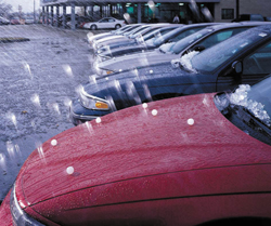
 Andy Lyons/Getty Images
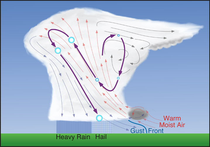 www.physicalgeography.net
 Weather Story
 Weather Map
 Local Radar