Louisville, KY
Weather Forecast Office
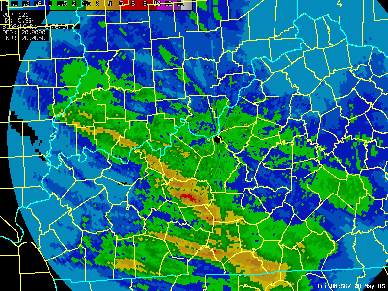 |
NWS Doppler radar produces 1-hour, 3-hour, user-defined, and storm-total precipitation estimates. Although limitations exist, the overall estimates usually are quite good and alert forecasters to locations where heavy precipitation is or has occurred. This is very important, for example, during thunderstorm events where forecasters need to assess flash flood potential as necessary. Dual-pol now also produces precipitation estimates based on various new algorithms. At left is a storm total precipitation estimate on May 20, 2005 that showed a band of heavy convective rainfall across southwest Indiana and central Kentucky. Estimated amounts of 2.5-5 inches (yellow shades) were noted with up to 6 inches (red) over Grayson County. Other heavy rainfall occurred over south-central Kentucky. The data can be animated to see where accumulation is most rapid. |
Current Hazards
Hazardous Weather Outlook
Storm Prediction Center
Submit a Storm Report
Advisory/Warning Criteria
Radar
Fort Knox
Evansville
Fort Campbell
Nashville
Jackson
Wilmington
Latest Forecasts
El Nino and La Nina
Climate Prediction
Central U.S. Weather Stories
1-Stop Winter Forecast
Aviation
Spot Request
Air Quality
Fire Weather
Recreation Forecasts
1-Stop Drought
Event Ready
1-Stop Severe Forecast
Past Weather
Climate Graphs
1-Stop Climate
CoCoRaHS
Local Climate Pages
Tornado History
Past Derby/Oaks/Thunder Weather
Football Weather
Local Information
About the NWS
Forecast Discussion
Items of Interest
Spotter Training
Regional Weather Map
Decision Support Page
Text Products
Science and Technology
Outreach
LMK Warning Area
About Our Office
Station History
Hazardous Weather Outlook
Local Climate Page
Tornado Machine Plans
Weather Enterprise Resources
US Dept of Commerce
National Oceanic and Atmospheric Administration
National Weather Service
Louisville, KY
6201 Theiler Lane
Louisville, KY 40229-1476
502-969-8842
Comments? Questions? Please Contact Us.


 Weather Story
 Weather Map
 Local Radar