Louisville, KY
Weather Forecast Office
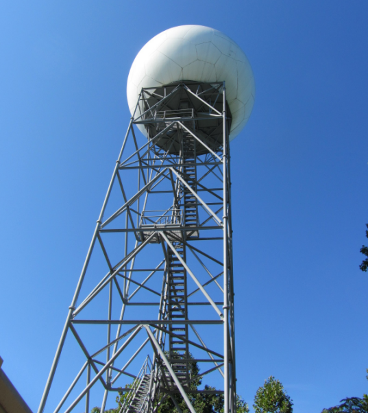 |
This is the Radar Data Acquisition (RDA) of the NWS Louisville-Ft. Knox (KLVX) WSR-88D Doppler radar. The RDA is located at Ft. Knox, KY. Inside the large white protective covering (radome) is a huge antenna that continuously rotates sending signals to and receiving signals from targets in the atmosphere. These targets are "hydrometeors," ranging from very small, non-precipitating particles (virga) to very large raindrops and hail from thunderstorms. The antenna also can sense movement of particles directed toward and away from the RDA (the "Doppler effect"), which allows calculation and assessment of winds and rotation in the atmosphere, especially within severe thunderstorms. The antenna is very sensitive and powerful, allowing forecasters to evaluate the structure, evolution, and motion of precipitation systems in great detail. Yet, the antenna transmits only a small fraction of the time, and "listens" for returned power from precipitation targets the rest of the time. The RDA can be controlled by staff members at NWS Louisville. Data received at the RDA is processed and sent to NWS Louisville for further processing before final display of various radar products on AWIPS workstations for observation, forecast, and warning purposes. |
Back to NWS Doppler Radar Images | Back to NWS Doppler Radar Overview
Current Hazards
Hazardous Weather Outlook
Storm Prediction Center
Submit a Storm Report
Advisory/Warning Criteria
Radar
Fort Knox
Evansville
Fort Campbell
Nashville
Jackson
Wilmington
Latest Forecasts
El Nino and La Nina
Climate Prediction
Central U.S. Weather Stories
1-Stop Winter Forecast
Aviation
Spot Request
Air Quality
Fire Weather
Recreation Forecasts
1-Stop Drought
Event Ready
1-Stop Severe Forecast
Past Weather
Climate Graphs
1-Stop Climate
CoCoRaHS
Local Climate Pages
Tornado History
Past Derby/Oaks/Thunder Weather
Football Weather
Local Information
About the NWS
Forecast Discussion
Items of Interest
Spotter Training
Regional Weather Map
Decision Support Page
Text Products
Science and Technology
Outreach
LMK Warning Area
About Our Office
Station History
Hazardous Weather Outlook
Local Climate Page
Tornado Machine Plans
Weather Enterprise Resources
US Dept of Commerce
National Oceanic and Atmospheric Administration
National Weather Service
Louisville, KY
6201 Theiler Lane
Louisville, KY 40229-1476
502-969-8842
Comments? Questions? Please Contact Us.


 Weather Story
 Weather Map
 Local Radar