Louisville, KY
Weather Forecast Office
 |
|
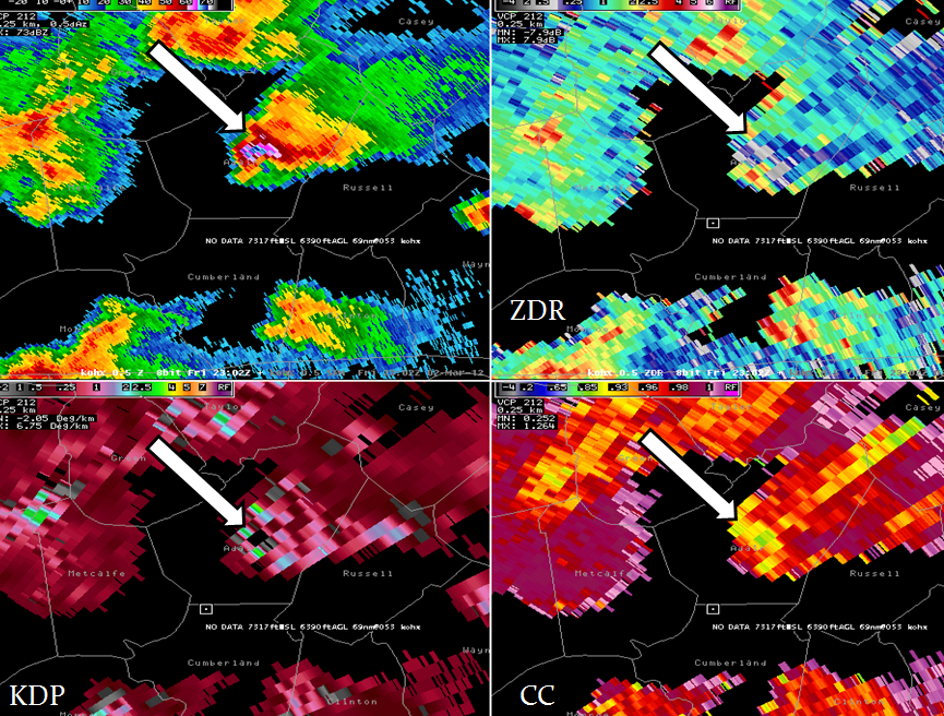
Conventional Doppler radar sends out a horizontal energy pulse providing a one�dimensional view of precipitation. Dual pol radar sends both horizontal and vertical pulses, providing a two�dimensional view. Thus, it provides much better information about the size, shape, and estimated amount of precipitation, distinguishing between rain, snow, and hail. Basic dual pol products include correlation coefficient (CC), differential reflectivity (ZDR), and specific differential phase (KDP). More information is available on our Dual Pol webpage. High reflectivity was present in a supercell on March 2, 2012 over central Kentucky (upper left; white arrow). Here, ZDR (upper right) showed low values (white color) indicating spherical shapes suggestive of large hailstones. CC (lower right) showed values of 0.8-0.95 (yellow/green) indicative of a combination of large hail and wet hail/rain. KDP (lower left), which helps assess rain drop size/density, showed a small black area (data dropout), surrounded by values of 1-3 (blue-green). This also denoted large hail, surrounded by small hail and large drops. Thus, dual pol clearly identified large hail in the storm, which produced at least golf ball size. Reflectivity alone (upper left) suggested large hail, but could not confirm it as high values can also mean a lot of small hail and/or a hail/very heavy rain mix. |
Current Hazards
Hazardous Weather Outlook
Storm Prediction Center
Submit a Storm Report
Advisory/Warning Criteria
Radar
Fort Knox
Evansville
Fort Campbell
Nashville
Jackson
Wilmington
Latest Forecasts
El Nino and La Nina
Climate Prediction
Central U.S. Weather Stories
1-Stop Winter Forecast
Aviation
Spot Request
Air Quality
Fire Weather
Recreation Forecasts
1-Stop Drought
Event Ready
1-Stop Severe Forecast
Past Weather
Climate Graphs
1-Stop Climate
CoCoRaHS
Local Climate Pages
Tornado History
Past Derby/Oaks/Thunder Weather
Football Weather
Local Information
About the NWS
Forecast Discussion
Items of Interest
Spotter Training
Regional Weather Map
Decision Support Page
Text Products
Science and Technology
Outreach
LMK Warning Area
About Our Office
Station History
Hazardous Weather Outlook
Local Climate Page
Tornado Machine Plans
Weather Enterprise Resources
US Dept of Commerce
National Oceanic and Atmospheric Administration
National Weather Service
Louisville, KY
6201 Theiler Lane
Louisville, KY 40229-1476
502-969-8842
Comments? Questions? Please Contact Us.


 Weather Story
 Weather Map
 Local Radar