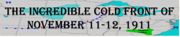
On November 11-12, 1911 a cold front barged across the central and eastern United States with such force that it is still remembered over a century later. In association with this front some cities set both a record high and a record low in the same day. Temperature plunges that have never been recorded before or since shocked the people who were in the cold blast's path. Huge thunderstorms erupted ahead of the front causing widespread wind damage as well as large hail and terrible tornadoes up to F4 in strength. Just hours after the thunderstorms hit, some locations were accosted with blizzard conditions.
Below are some weather maps describing the conditions on the 11th-12th. Click on an image for a larger version.
|
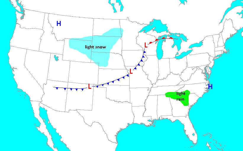
Weather map at 8am November 11, 1911. High pressure over Montana was introducing bitterly cold air to the Plains, resulting in snowfall behind the long cold front. Meanwhile, high pressure along the North Carolina coast was pumping warm Gulf of America air northward. |
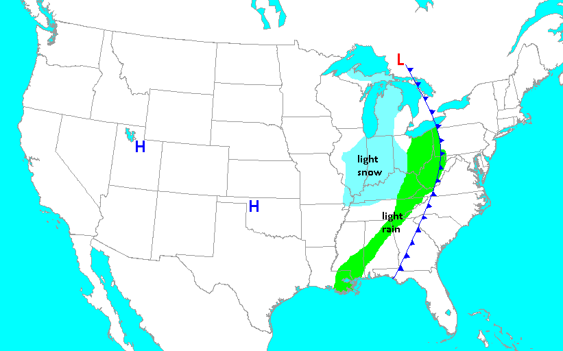
Weather map at 8am November 12, 1911. The cold front had rapidly advanced across the country. A band of showers and storms accompanied the front, with the precipitation changing to snow within a couple hours of the frontal passage. |
|
|
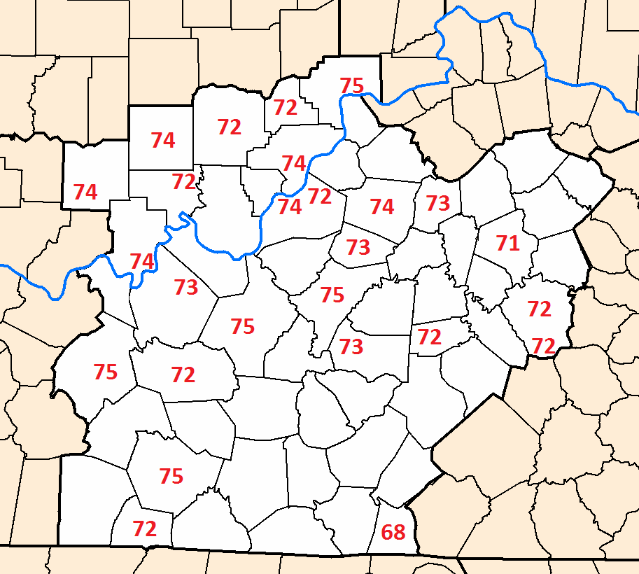
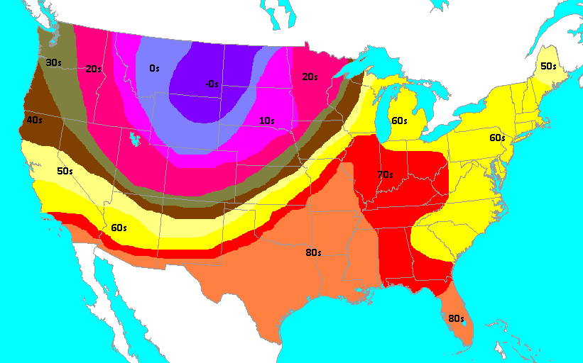
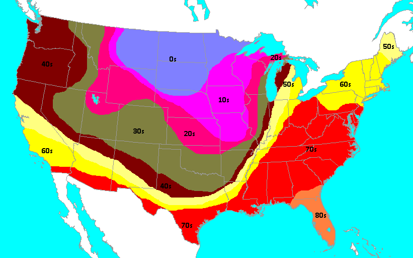
High temperatures on the 11th. The highs over the northern Plains and Rockies, behind the front, were set in the morning. Highs to the southeast of the front were reached in the afternoon. |
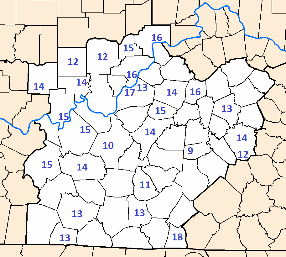
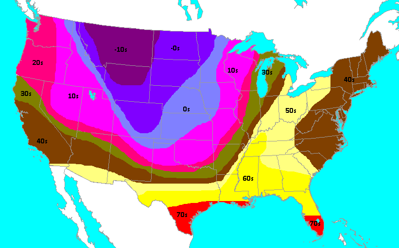
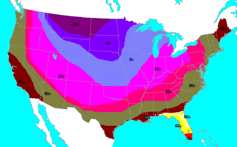
Low temperatures on the 11th, which were set at midnight that night. Note the amazing drop in temperature over the southern Plains and Midwest! |
High temperatures on November 12. The cold front can be plainly seen in its position at midnight at the start of the day. The front hit Louisville at 12:30am. |
Low temperatures on the 12th, set that evening. The warm air ahead of the front was suppressed into Florida, while much of the rest of the nation shivered. |
Several factors came together to produce this historic weather event. Arctic air had collected near the North Pole, and had stayed in place for a long enough period of time to become truly frigid. By the 10th of the month a powerful burst of jet stream winds came in from the west and picked up the huge dome of icy air over northern Canada. The jet stream dove south on the 11th, forcing the cold air southward into the U.S. At the same time, a strong ridge of high pressure over the southeast U.S. and western Atlantic Ocean was sweeping unusually warm and humid air well northward into the central United States. The wild weather was a result of the bone chilling air diving south crashing into the spring-like air rushing north, combined with strong jet stream winds high up in the atmosphere in the middle of it all.
While it is true that deadly storms accompanied the cold front, the temperature changes that occurred with the front were so spectacular that they have taken center stage in meteorological remembrances of the event. Below are a few examples.
| Location | Changes |
| Kansas City, Missouri | 76° at noon, 11° fourteen hours later at 2am on the 12th. |
| Columbia, Missouri | 82° at 2pm, 38° at 3pm, with a record high and low (13°) set on the same day. Sleet at 4pm. Several locations around central Missouri reported a temperature drop of thirty degrees in twenty minutes. A couple of observers reported afternoon highs in the mid 70s followed by one to two inches of snow that evening. |
| Springfield, Missouri | 80° at 3:45pm, 21° at 7pm, 13° at midnight that night (a drop of 67 degrees in ten hours!). Both a record high and record low were set that day, and still stand. Winds to 54mph for five minutes with gusts to 74mph accompanied the passage of the front, causing damage to buildings. Thunderstorms brought hail, followed by rain, which turned to sleet less than two hours after the 80° reading earlier in the afternoon. The barometric pressure, reduced to sea level, bottomed out at 29.33" and then rose one inch in 17 hours. |
| Oklahoma City, Oklahoma | Fell from 83° to 17°, setting both a record high and a record low in the same day that still stand. A dust storm accompanied the front. |
| Saint Louis, Missouri | High of 78°. 75° at 6:10pm, 49° at 6:20pm, 17° at 1am on the 12th. In nearby Saint Charles strong winds blew down a church steeple, unroofed homes, and felled trees during a 17-minute long hailstorm. |
| Chicago, Illinois | A railroad employee died from heat prostration on the morning of the 11th, and 19 hours later a man froze to death after taking a fall outside and not being discovered until the next day. |
| Louisville, Kentucky | On the morning of the 12th the temperature fell from 74° at midnight to 50° at 1am, and was into the mid 20s by the time the sun came up that morning. Winds to 48 mph accompanied the front around 12:30am. When Louisville was in the mid 70s at midnight, Saint Louis was in the upper teens. |
| Lexington, Kentucky | Fell from 70° early in the morning to a record low of 14° by the end of the day. |
| Bowling Green, Kentucky | Fell from 75° to 22° over the course of the day on the 12th. |
 |
These are temperature and pressure traces taken at Louisville on the 11th. On the left the temperature is shown to steadily rise through the day, drop a bit in the evening when the sun sets, and then rise again just ahead of the approaching front. On the right, the pressure trace shows how the barometric pressure fell throughout the day as the storm approached. (Click on the image to see a much larger version.) |
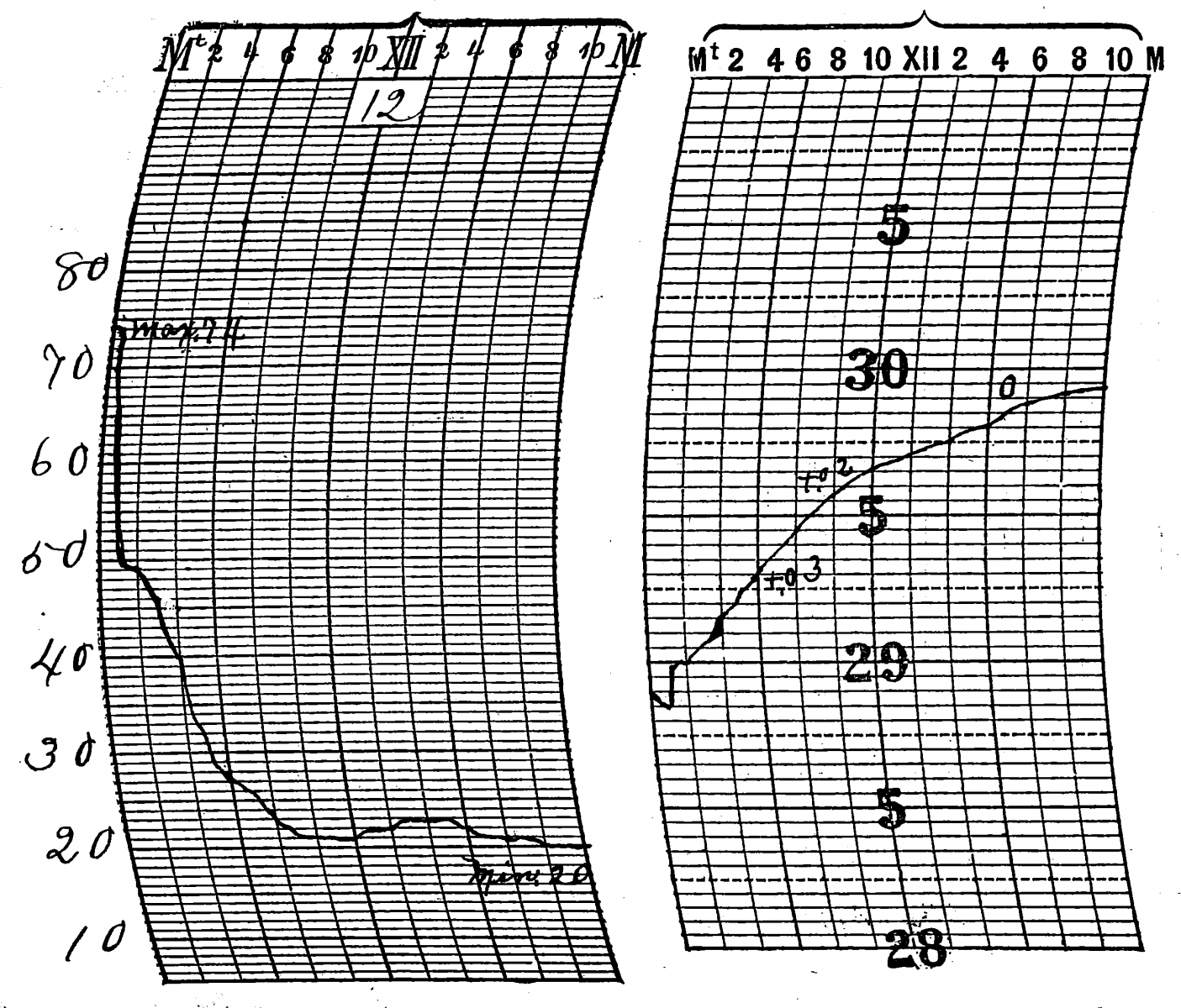 |
The cold front struck at 12:30am, as shown by the precipitous fall in temperature on the trace in the left. The barometric pressure rose accordingly as the cold front exited to the east. (Click on the image to see a much larger version.) |
 |
High temperatures ahead of the front. (Click on the image for a larger version.) |
 |
Low temperatures behind the front. Remember that this was only mid-November, and there was no snow on the ground! (Click on the image for a larger version.) |
|
Closer to home, the entire state of Indiana was swept by strong, damaging winds. Great losses to property and agriculture were reported, along with many injuries and at least one death. In Kentucky there were losses reported throughout the Commonwealth, with the greatest concentration of destruction in the western portion. Homes and barns were unroofed and telephone, telegraph, and railroad services were greatly hindered. Louisville was cut off from communication with surrounding cities for several hours. |


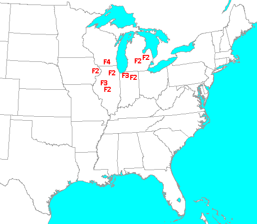 A tornado outbreak took place in the Great Lakes region where the strongest upper winds interacted with the sharp cold front. The area around Janesville, Wisconsin was the hardest hit as an F4 twister flattened farms and took nine lives. It was the worst tornado outbreak ever seen in November in the north-central U.S. with several F2-F4 tornadoes and thirteen fatalities. To add insult to injury, the tornadoes were followed by terrible cold and wind. People helping with the Janesville disaster had to do their grim tornado recovery work in blizzard conditions.
 Weather Story
 Weather Map
 Local Radar