Louisville, KY
Weather Forecast Office
After a wet January and wet February, the region turned drier in March, and much of the month's rain fell on the 6th-7th in conjunction with a slow-moving cold front. Warm temperatures prevailed for much of the month, but a cold snap from the 8th to the 13th brought sub-freezing readings and the month's most significant snowfall when up to half a foot of snow fell on the 11th-12th. With fresh snow on the ground, temperatures tumbled into the teens on the 12th and 13th.
The only significant severe weather event of the month took place on the evening of the 18th. Low pressure moving from Missouri to Indiana generated scattered thunderstorms. There was enough shear in the atmosphere to allow for rotation in some of the storms, and that rotation led to five brief, weak tornadoes.
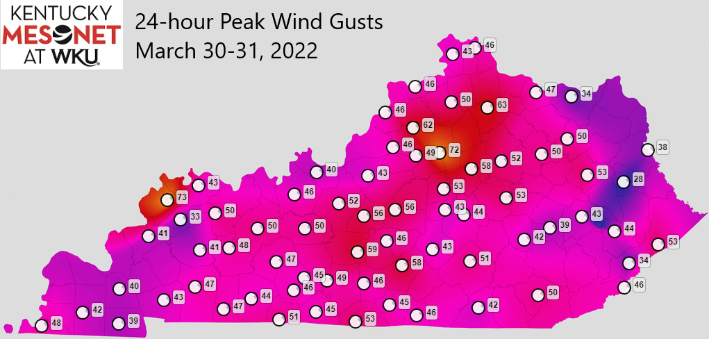
On the 30th an impressively strong spring storm system centered over the Great Lakes created extremely strong non-thunderstorm winds throughout the Ohio Valley. Wind gusts of 45-50 mph were common, and the Franklin County Mesonet site hit 72 mph! In Louisville, Bowman Field topped out at 68 mph and Louisville International at 63 mph. Fortunately damage was relatively minor.
| Average Temperature | Departure from Normal | Precipitation | Departure from Normal | Snow | Departure from Normal | |
| Bowling Green | 51.7° | +2.5° | 2.96" | -1.58" | 5.1" | +3.7" |
| Frankfort | 48.6° | +2.4° | 3.42" | -1.30" | ||
| Lexington | 48.5° | +2.6° | 4.27" | -0.21" | 5.5" | +2.7" |
| Louisville Ali (SDF) | 51.7° | +3.3° | 2.37" | -2.23" | 1.5" | -0.7" |
| Louisville Bowman (LOU) | 50.2° | +2.8° | 2.44" | -1.93" |
Records
5th: High of 77° at Louisville
11th: Snowfall of 4.7" at Bowling Green, snowfall of 4.5" at Lexington
12th: Cold high of 30° at Bowling Green, cold high of 28° at Frankfort, cold high of 24° at Lexington, cold high of 30° at Louisville
30th: High of 84° at Louisville

Current Hazards
Hazardous Weather Outlook
Storm Prediction Center
Submit a Storm Report
Advisory/Warning Criteria
Radar
Fort Knox
Evansville
Fort Campbell
Nashville
Jackson
Wilmington
Latest Forecasts
El Nino and La Nina
Climate Prediction
Central U.S. Weather Stories
1-Stop Winter Forecast
Aviation
Spot Request
Air Quality
Fire Weather
Recreation Forecasts
1-Stop Drought
Event Ready
1-Stop Severe Forecast
Past Weather
Climate Graphs
1-Stop Climate
CoCoRaHS
Local Climate Pages
Tornado History
Past Derby/Oaks/Thunder Weather
Football Weather
Local Information
About the NWS
Forecast Discussion
Items of Interest
Spotter Training
Regional Weather Map
Decision Support Page
Text Products
Science and Technology
Outreach
LMK Warning Area
About Our Office
Station History
Hazardous Weather Outlook
Local Climate Page
Tornado Machine Plans
Weather Enterprise Resources
US Dept of Commerce
National Oceanic and Atmospheric Administration
National Weather Service
Louisville, KY
6201 Theiler Lane
Louisville, KY 40229-1476
502-969-8842
Comments? Questions? Please Contact Us.


 Weather Story
 Weather Map
 Local Radar