Louisville, KY
Weather Forecast Office
June 2023 started off dry with a stripe of moderate drought stretching from Frankfort and Carlisle south to Greensburg and Jamestown. Fortunately temperatures were near normal, with just minor impact to local agriculture. After several days without precipitation, rains did bring some relief on the 7th, with a narrow band of about an inch of rain reaching from Louisville to Liberty. While this did not reduce the drought, it kept it in check.
Low pressure moving from Saint Louis to Cleveland brought severe storms to the Lake Cumberland region on the 11th. Golf ball sized hail was reported near Argyle in Casey County and some wind damage was done at Green River Lake State Park. Cool weather followed the system with daily average temperatures on the 12th and 13th eight to thirteen degrees below normal.
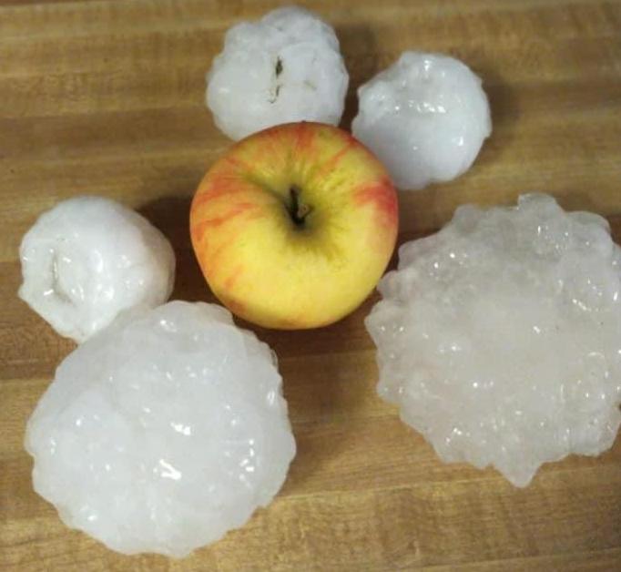
Two waves of powerful thunderstorms, one in the morning and one in the evening, brought widespread severe weather to the entire region on the 25th-26th. NWS Louisville issued a total of 64 warnings, with every county in southern Indiana and central Kentucky being under at least one warning at some point. Three tornadoes struck the area, including a short-lived EF2 near Cecilia in Hardin County. Huge hail three inches in diameter (slightly larger than a baseball) struck French Lick in Orange County, damaging the West Baden Springs Hotel's famous atrium roof. The hail pounded huge divots into the Pete Dye Golf Course.
Just a few days later, three waves of storms swept through on the 29th, causing scattered wind damage especially in southern Indiana and central Kentucky west of Interstate 65.
| Average Temperature | Departure from Normal | Precipitation | Departure from Normal | |
| Bowling Green | 74.1° | -2.0° | 2.65" | -1.86" |
| Frankfort | 69.9° | -3.8° | 5.96" | +1.62" |
| Lexington | 71.5° | -1.8° | 6.75" | +1.79" |
| Louisville Ali | 74.4° | -2.0° | 4.99" | +0.72" |
| Louisville Bowman | 71.1° | -4.3° | 4.35" | -0.33" |
Records
11th: Rainfall of 1.10" at Frankfort
25th: Rainfall of 2.17" at Louisville
30th: Rainfall of 2.57" at Lexington
10th coolest June on record at Frankfort

Big hail in French Lick, Indiana on the 25th. Courtesy of Sandy Hercamp via Marc Weinberg
Current Hazards
Hazardous Weather Outlook
Storm Prediction Center
Submit a Storm Report
Advisory/Warning Criteria
Radar
Fort Knox
Evansville
Fort Campbell
Nashville
Jackson
Wilmington
Latest Forecasts
El Nino and La Nina
Climate Prediction
Central U.S. Weather Stories
1-Stop Winter Forecast
Aviation
Spot Request
Air Quality
Fire Weather
Recreation Forecasts
1-Stop Drought
Event Ready
1-Stop Severe Forecast
Past Weather
Climate Graphs
1-Stop Climate
CoCoRaHS
Local Climate Pages
Tornado History
Past Derby/Oaks/Thunder Weather
Football Weather
Local Information
About the NWS
Forecast Discussion
Items of Interest
Spotter Training
Regional Weather Map
Decision Support Page
Text Products
Science and Technology
Outreach
LMK Warning Area
About Our Office
Station History
Hazardous Weather Outlook
Local Climate Page
Tornado Machine Plans
Weather Enterprise Resources
US Dept of Commerce
National Oceanic and Atmospheric Administration
National Weather Service
Louisville, KY
6201 Theiler Lane
Louisville, KY 40229-1476
502-969-8842
Comments? Questions? Please Contact Us.


 Weather Story
 Weather Map
 Local Radar