Louisville, KY
Weather Forecast Office
June was our second consecutive very warm month in central Kentucky and southern Indiana, landing in the top ten warmest on record at Bowling Green and Louisville. This was primarily achieved through temperatures that were only slightly above normal on any given day, but persistent through most of the month. No significant heat waves struck and no record highs were met. We had a lot of moderately warm days, several very warm nights, and just a few cool days. The warmest spell during the month was from the 17th to the 19th when daily average temperatures were about 8 to 10 degrees above normal. The coolest day of the month was on the 4th when temperatures were 2 to 3 degrees below normal and many locations enjoyed morning lows in the 50s.
Scattered summertime thunderstorms delivered rainfall to the region, with some folks getting doused and others receiving less. The map below shows a stripe of very wet conditions across central Kentucky and southwest Indiana with lesser amounts north and south.
 |
| Percentage of normal rainfall, June 2018 |
With those scattered storms came occasional severe weather, usually in the form of gusty winds. The most significant thunderstorms of the month came on the 25th and 26th as several rounds of intense storms rolled through the region. On the 25th small tornadoes touched down in Ohio and Edmonson counties. On the 26th an EF-1 tornado formed in Worthington Hills on the far east side of Jefferson County and proceeded east for about three and a half miles through Pewee Valley.
| Average Temperature | Departure from Normal | Rain | Departure from Normal | |
| Bowling Green | 79.6° | +4.6° | 3.33" | -0.87" |
| Frankfort | 75.9° | +3.3° | 5.24" | +1.15" |
| Lexington | 75.8° | +3.1° | 3.92" | -0.52" |
| Louisville Bowman | 78.1° | +3.0° | 6.82" | +2.68" |
| Louisville International | 79.2° | +3.6° | 6.38" | +2.59" |
Records
2nd: Warm low of 72° at Bowling Green
19th: Warm low of 77° at Bowling Green, warm low of 73° at Lexington, warm low of 78° at Louisville
25th: Record rainfall of 1.88" at Frankfort
5th warmest June on record at Louisville
9th warmest June on record at Bowling Green
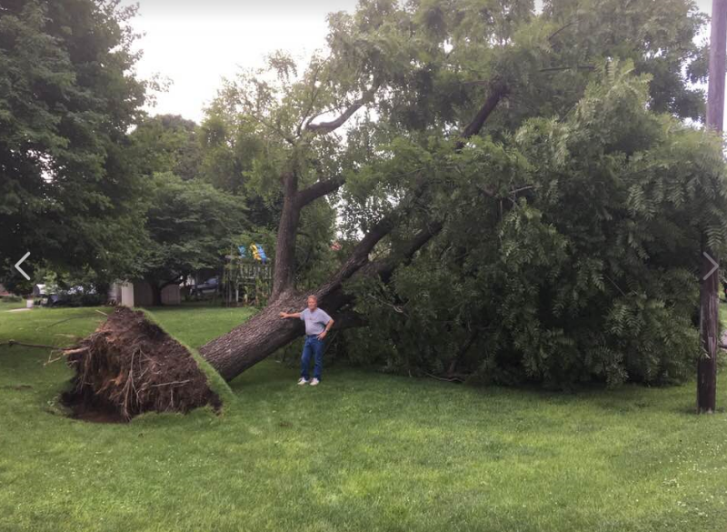
Powerful thunderstorm winds felled this walnut tree in Holland, Indiana on the 26th.
Current Hazards
Hazardous Weather Outlook
Storm Prediction Center
Submit a Storm Report
Advisory/Warning Criteria
Radar
Fort Knox
Evansville
Fort Campbell
Nashville
Jackson
Wilmington
Latest Forecasts
El Nino and La Nina
Climate Prediction
Central U.S. Weather Stories
1-Stop Winter Forecast
Aviation
Spot Request
Air Quality
Fire Weather
Recreation Forecasts
1-Stop Drought
Event Ready
1-Stop Severe Forecast
Past Weather
Climate Graphs
1-Stop Climate
CoCoRaHS
Local Climate Pages
Tornado History
Past Derby/Oaks/Thunder Weather
Football Weather
Local Information
About the NWS
Forecast Discussion
Items of Interest
Spotter Training
Regional Weather Map
Decision Support Page
Text Products
Science and Technology
Outreach
LMK Warning Area
About Our Office
Station History
Hazardous Weather Outlook
Local Climate Page
Tornado Machine Plans
Weather Enterprise Resources
US Dept of Commerce
National Oceanic and Atmospheric Administration
National Weather Service
Louisville, KY
6201 Theiler Lane
Louisville, KY 40229-1476
502-969-8842
Comments? Questions? Please Contact Us.


 Weather Story
 Weather Map
 Local Radar