Louisville, KY
Weather Forecast Office
January 2023 stayed true to La Niña with wetter than normal conditions. Along with the wet pattern, temperatures remained quite warm overall, with only 3 to 5 days of the month, depending on location, with an average daily temperature that was colder than normal. While we did have some wintry precipitation, the warm temperatures kept monthly snowfall amounts very low. Most of the snowfall was restricted to southern Indiana, and even there totals for the month were on the order of three to five inches.
Similar to 2022, 2023 started off with a significant storm system rolling through the region. From the 2nd into the 3rd about 2.50-5.50" of rain fell in a broad corridor generally from Owensboro through Elizabethtown and Louisville to Lexington and the northern Blue Grass. Many reports of flooding were received and there were several water rescues, including one for a school bus in Bourbon County.
Relatively warm temperatures enveloped the region from the 4th to the 13th with many afternoons seeing temperatures in the 50s and 60s. Unfortunately on the 12th several rounds of thunderstorms moved through the area during the early morning hours, spawning four EF-1 tornadoes between 8:47am and 9:45am. Though there was some property damage, no one was hurt.
The most widespread snowfall of the month took place on the 21st-22nd when 1-3" of snow fell from southern Indiana into northern Kentucky. A couple of spots between English and Salem topped four inches. However, the most impactful snow of the month occurred on the early morning of the 27th. Two narrow bands of snow set up from just east of Louisville to the north side of the Lexington metropolitan area. Although most reports that came in indicated only about half an inch of snow fell, traffic on the interstates compacted it into a slick layer of ice, resulting in many accidents and causing the interstates around Lexington to be closed down for several hours.
| Average Temperature | Departure from Normal | Precipitation | Departure from Normal | Snow | Departure from Normal | |
| Bowling Green | 44.9° | +7.7° | 4.82" | +1.18" | T | -3.2" |
| Frankfort | 41.7° | +7.6° | 5.82" | +2.55" | ||
| Lexington | 43.0° | +9.1° | 6.29" | +2.87" | 0.7" | -4.0" |
| Louisville Ali | 43.4° | +7.7° | 5.36" | +1.97" | 1.2" | -3.3" |
| Louisville Bowman | 41.5° | +6.5° | 4.99" | +1.71" |
Records
3rd: Rainfall of 3.04" at Frankfort, warm low of 60° at Louisville
Bowling Green's 6th warmest January
Frankfort's 10th warmest January
Lexington's 2nd warmest January
Louisville's 4th warmest January
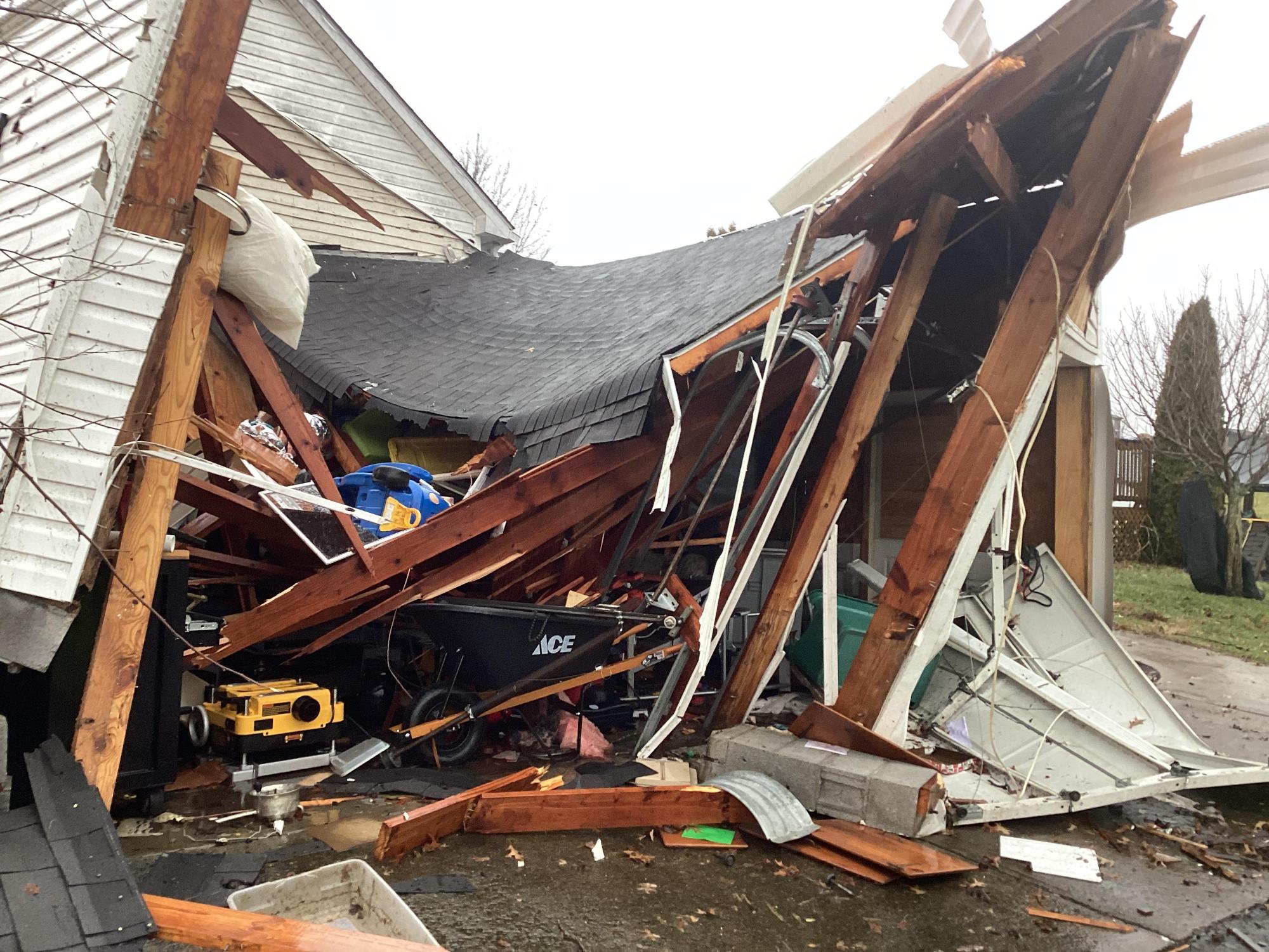
Tornado damage near Harrodsburg on the 12th. NWS storm survey
Current Hazards
Hazardous Weather Outlook
Storm Prediction Center
Submit a Storm Report
Advisory/Warning Criteria
Radar
Fort Knox
Evansville
Fort Campbell
Nashville
Jackson
Wilmington
Latest Forecasts
El Nino and La Nina
Climate Prediction
Central U.S. Weather Stories
1-Stop Winter Forecast
Aviation
Spot Request
Air Quality
Fire Weather
Recreation Forecasts
1-Stop Drought
Event Ready
1-Stop Severe Forecast
Past Weather
Climate Graphs
1-Stop Climate
CoCoRaHS
Local Climate Pages
Tornado History
Past Derby/Oaks/Thunder Weather
Football Weather
Local Information
About the NWS
Forecast Discussion
Items of Interest
Spotter Training
Regional Weather Map
Decision Support Page
Text Products
Science and Technology
Outreach
LMK Warning Area
About Our Office
Station History
Hazardous Weather Outlook
Local Climate Page
Tornado Machine Plans
Weather Enterprise Resources
US Dept of Commerce
National Oceanic and Atmospheric Administration
National Weather Service
Louisville, KY
6201 Theiler Lane
Louisville, KY 40229-1476
502-969-8842
Comments? Questions? Please Contact Us.


 Weather Story
 Weather Map
 Local Radar