Louisville, KY
Weather Forecast Office
February 2019 was a very busy month for Ohio Valley meteorologists!
Rain fell on the region every day from the 4th to the 8th, with the heaviest rains falling on southern Indiana and north central Kentucky, totaling one to three inches. This led to rises on area rivers and some minor flooding.
A light wintry mix then came in on the morning of the 10th, followed by another round of widespread rains from the 10th through the 12th when many locations picked up another one to three inches of rain, especially along and south of Interstate 64. Gusty winds accompanied the rain on the 12th, with Danville, KY receiving an isolated gust of 58 mph.
More wintry mix, including more rain, moved through the Ohio Valley from the 15th to the 17th. On the morning of the 16th some impressive snows set up in the southern Blue Grass and Lake Cumberland region where 3-5" piled up from Hodgenville to Liberty.
After some light rain on the 18th and 19th, rains returned with a vengeance on the 20th with yet another one to three inch rainfall event. This was followed on the 22nd-24th with three inches of rain across the southern half of Kentucky. Rivers throughout the region, including the Ohio, surged out of their banks. Some streams remained in flood through the end of the month.
The storm system that brought flooding rains on the 23rd also produced very strong winds as it departed on the 24th. Winds gusted 40 to 55 mph.
| Average Temperature | Departure from Normal | Precipitation | Departure from Normal | Snow | Departure from Normal | |
| Bowling Green | 45.3° | +5.5° | 11.14" | +7.18" | 0.3" | -3.0" |
| Frankfort | 42.1° | +5.7° | 7.83" | +4.54" | ||
| Lexington | 42.5° | +5.6° | 7.39" | +4.19" | T | -4.6" |
| Louisville Bowman | 41.0° | +2.9° | 8.46" | +5.28" | ||
| Louisville International | 42.9° | +4.1° | 8.38" | +5.20" | 0.6" | -3.9" |
Records
3rd: High of 69° at Frankfort
6th: Warm low of 58° at Bowling Green, record precipitation of 1.78" at Bowling Green, warm low of 57° at Lexington, warm low of 51° at Louisville
7th: High of 73° at Bowling Green, high of 71° at Frankfort, rainfall of 1.16" at Frankfort, high of 72° at Lexington, high of 70° at Louisville, rainfall of 1.41" at Louisville
11th: Precipitation of 0.94" at Frankfort, precipitation of 0.91" at Lexington, precipitation of 1.54" at Louisville
20th: Precipitation of 1.86" at Frankfort, precipitation of 1.96" at Lexington
2nd wettest and 10th warmest February on record at Bowling Green
4th wettest February on record at Frankfort
6th wettest and 10th warmest February on record at Lexington
7th wettest February on record at Louisville
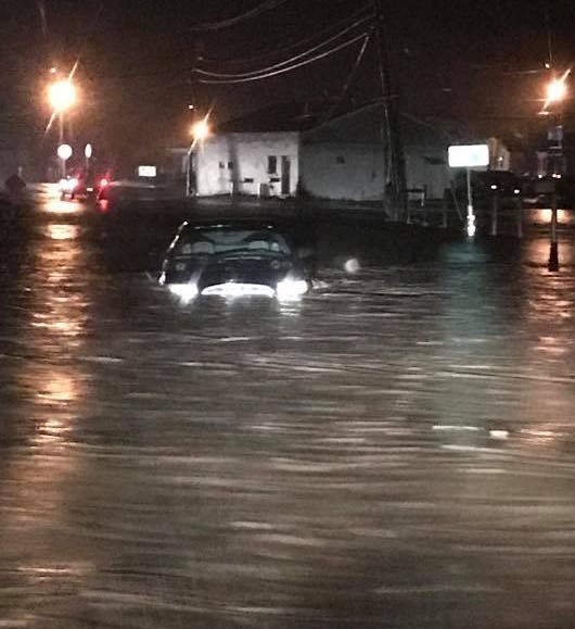
Flooding along Knob Lick Creek in Yosemite, Casey County, on the 23rd. Photo courtesy Crystal Sallee
Current Hazards
Hazardous Weather Outlook
Storm Prediction Center
Submit a Storm Report
Advisory/Warning Criteria
Radar
Fort Knox
Evansville
Fort Campbell
Nashville
Jackson
Wilmington
Latest Forecasts
El Nino and La Nina
Climate Prediction
Central U.S. Weather Stories
1-Stop Winter Forecast
Aviation
Spot Request
Air Quality
Fire Weather
Recreation Forecasts
1-Stop Drought
Event Ready
1-Stop Severe Forecast
Past Weather
Climate Graphs
1-Stop Climate
CoCoRaHS
Local Climate Pages
Tornado History
Past Derby/Oaks/Thunder Weather
Football Weather
Local Information
About the NWS
Forecast Discussion
Items of Interest
Spotter Training
Regional Weather Map
Decision Support Page
Text Products
Science and Technology
Outreach
LMK Warning Area
About Our Office
Station History
Hazardous Weather Outlook
Local Climate Page
Tornado Machine Plans
Weather Enterprise Resources
US Dept of Commerce
National Oceanic and Atmospheric Administration
National Weather Service
Louisville, KY
6201 Theiler Lane
Louisville, KY 40229-1476
502-969-8842
Comments? Questions? Please Contact Us.


 Weather Story
 Weather Map
 Local Radar