Overview
|
A potent low pressure system moved through the Midwest Monday, November 5, 2018. Showers and thunderstorms formed out ahead of the cold front trailing from this system. Central Kentucky saw a lot of rain, but then as the warm front lifted into southern Kentucky, a few storms became severe, causing damage. Three weak tornadoes were confirmed. Flooding was a minor issue as well, as saturated soils continue to allow water to pool from these heavy rain events. |
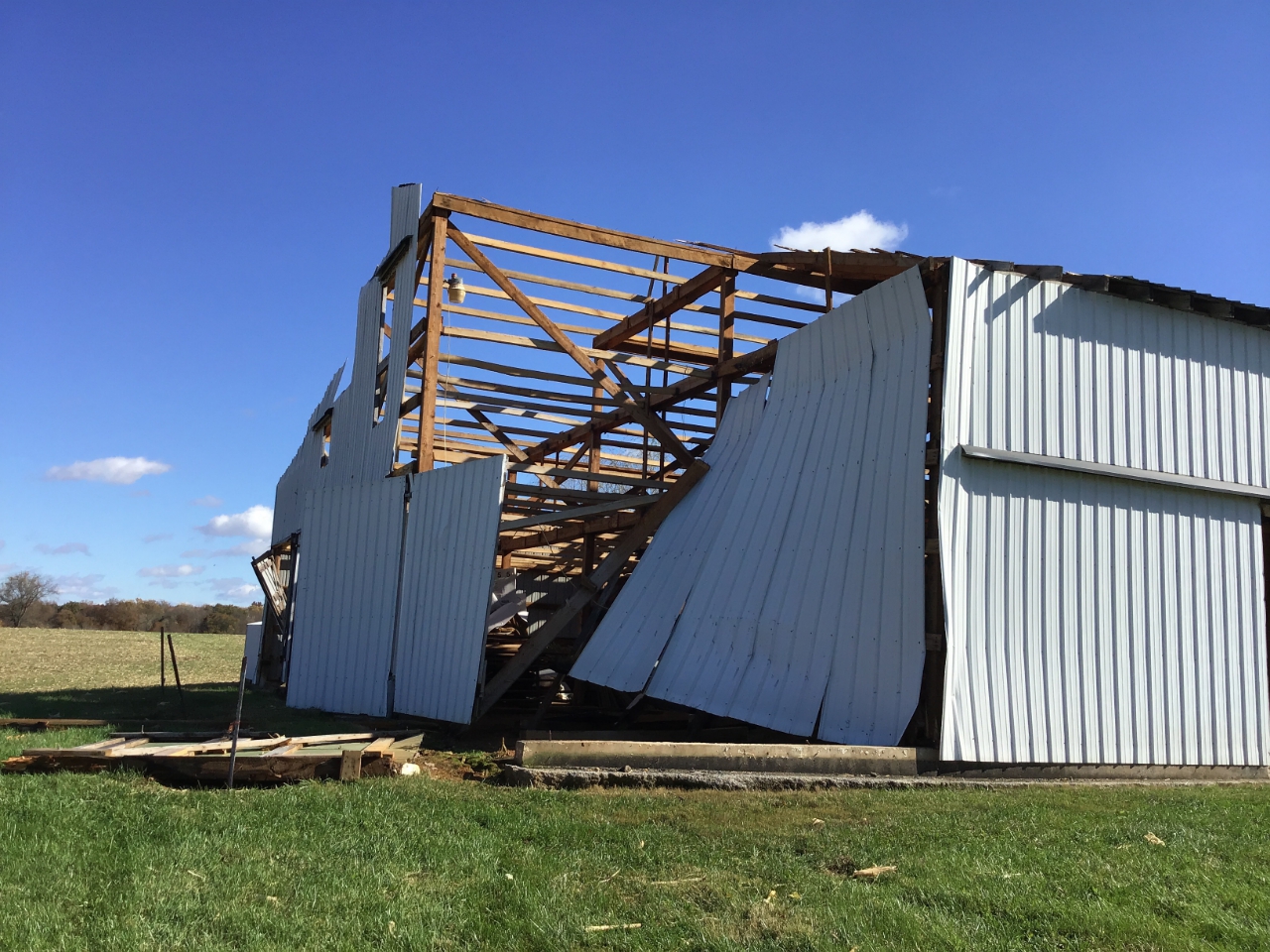 Barn damaged north of Columbia, KY in Adair county. |
Tornadoes:
|
|
||||||||||
|
||||||||||
|
Tornado - Near Columbia, KY
Track Map 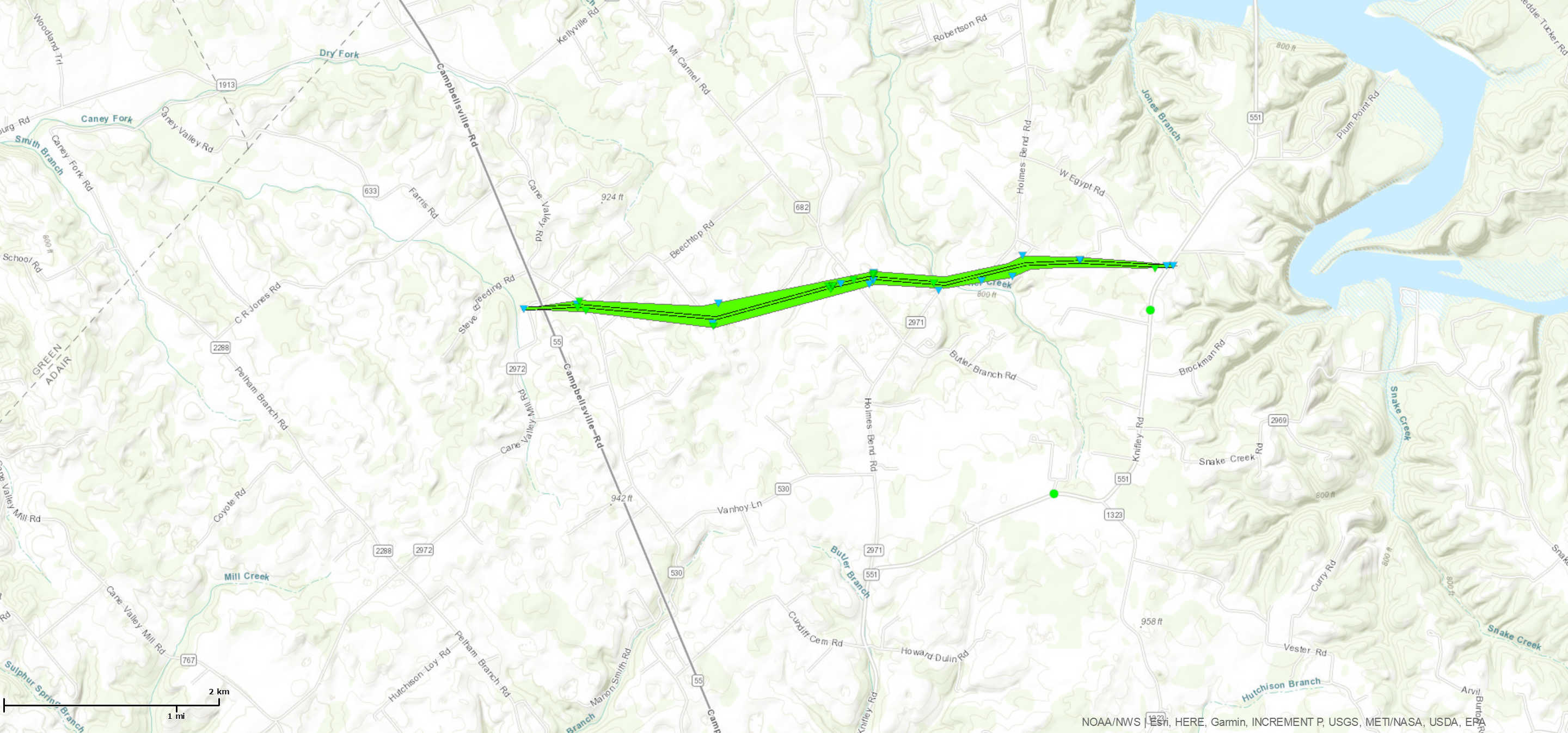 
Downloadable KMZ File |
||||||||||||||||
|
Tornado - Near Lebanon, KY
Track Map 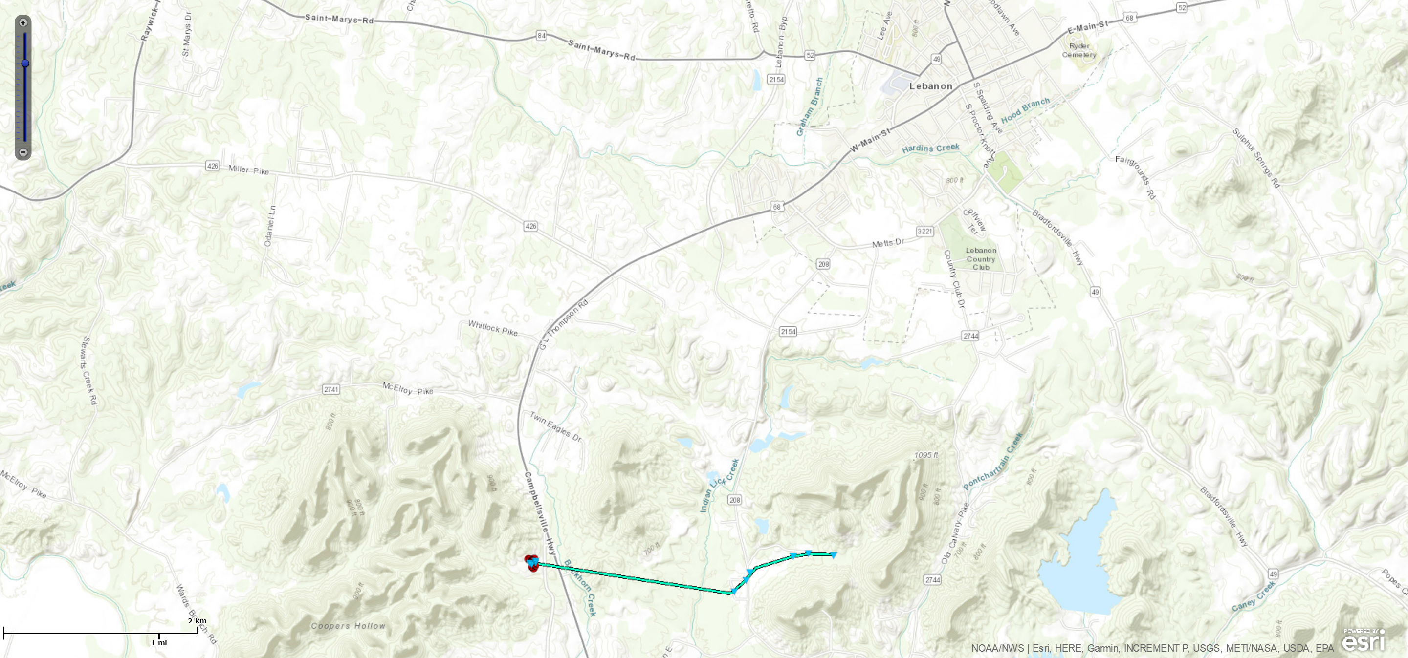
Downloadable KMZ File |
||||||||||||||||
|
Tornado - Near Brownsville, KY
Track Map 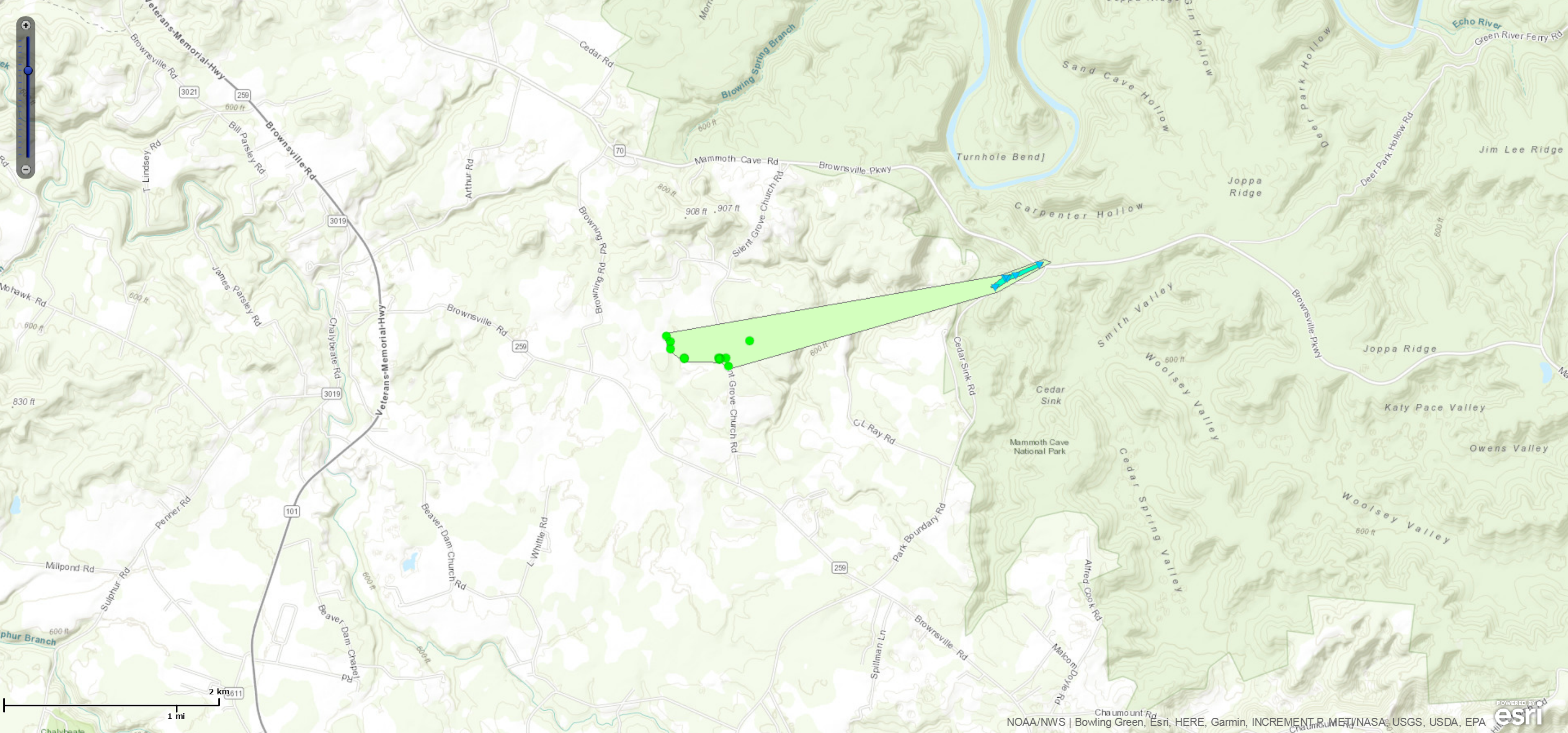
Downloadable KMZ File |
||||||||||||||||
The Enhanced Fujita (EF) Scale classifies tornadoes into the following categories:
| EF0 Weak 65-85 mph |
EF1 Moderate 86-110 mph |
EF2 Significant 111-135 mph |
EF3 Severe 136-165 mph |
EF4 Extreme 166-200 mph |
EF5 Catastrophic 200+ mph |
 |
|||||
Wind:
The strongest wind gusts associated with this event came late Monday evening/early overnight hours.
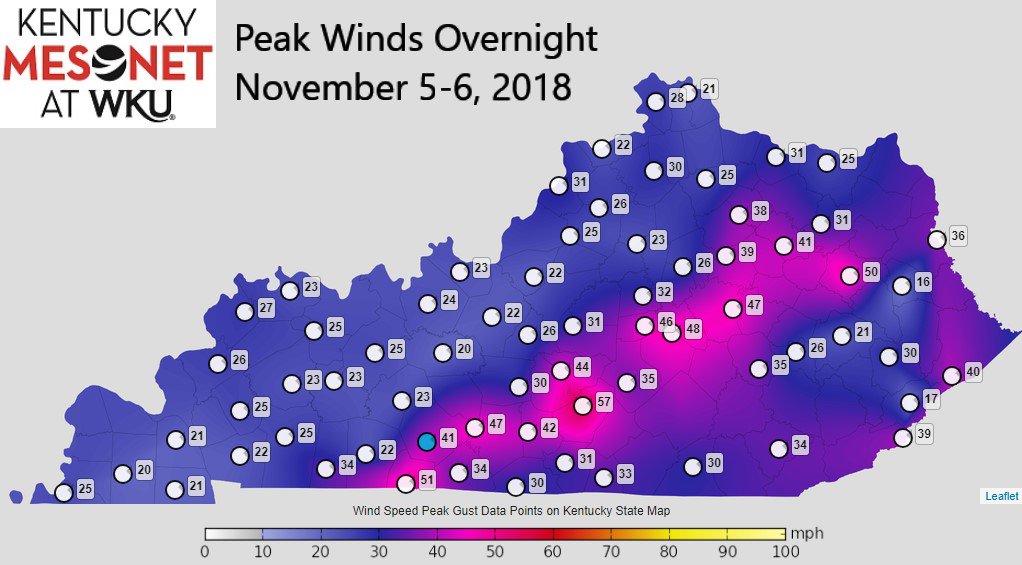 |
| Kentucky Mesonet peak winds from the squall line. |
Flooding
Add a written summary if needed.
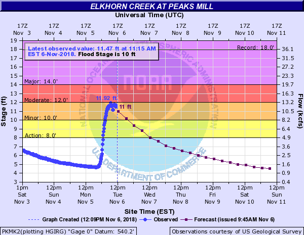
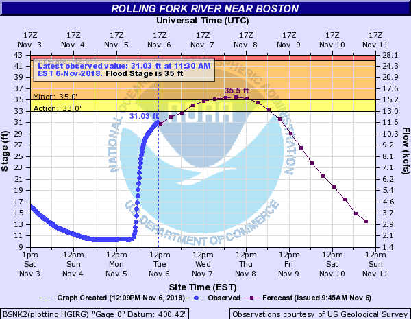
Hydrographs
 |
 |
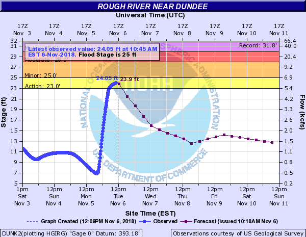 |
| River gauge on Elkhorn Creek near Peaks Mill, KY | Gauge on the Rolling Fork River near Boston, KY | Gauge on Rough River near Dundee, KY |
Radar/Photos
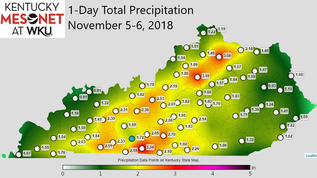 |
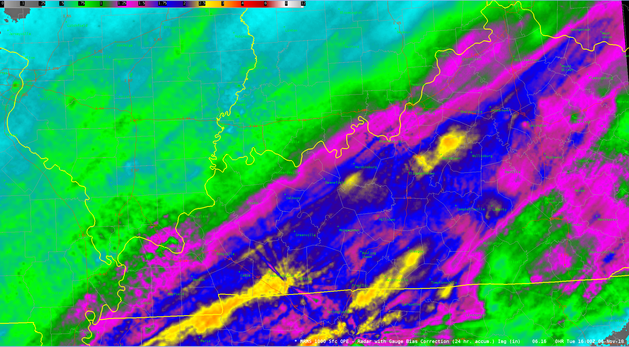 |
| 24-hour rainfall map from the Kentucky Mesonet | 24-hour rainfall estimate from the Multi-Radar/Multi-Sensor (MRMS) program. |
Radar:
Header
 |
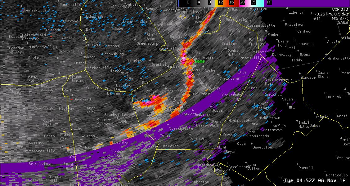 |
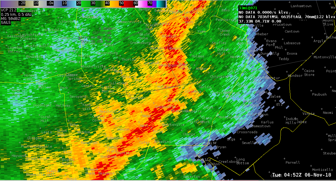 |
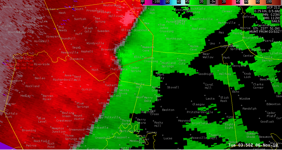
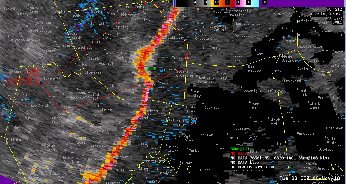
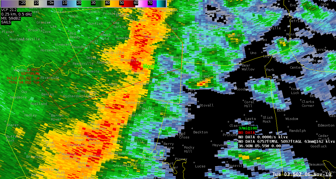
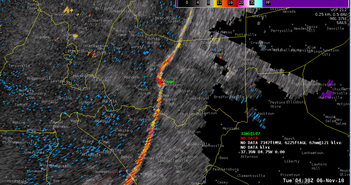
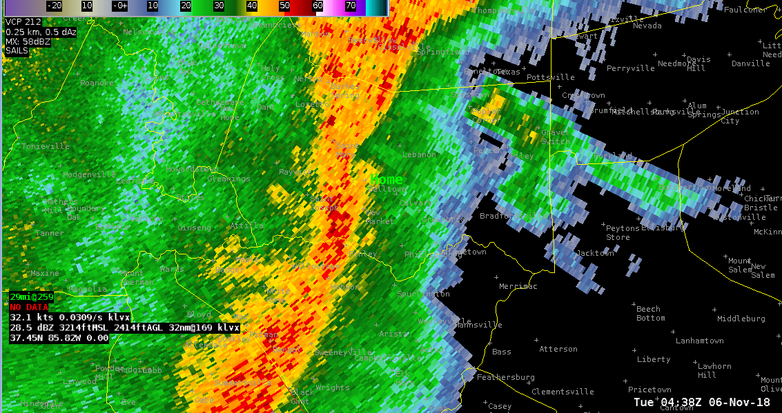
| Storm relative winds from the Ft. Knox radar (KLVX). Greens indicate relative inflow, with reds outflow. The "Home" location is where the tornado near Columbia, KY started causing damage. | A measure of how turbulent the winds were along the squall line Monday night. Brighter colors indicate lots of turbulent winds. Areas with "kinks" indicate some potential for tornadoes. | The reflectivity image, showing the line surging outward in the vicinity where the tornado developed. |
 |
 |
 |
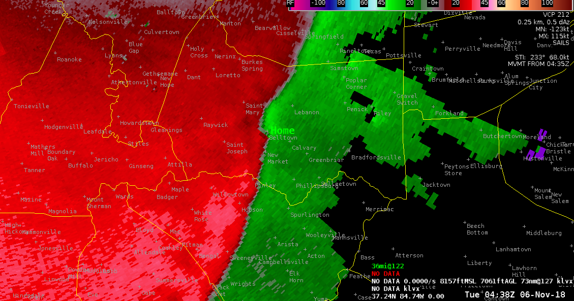
| Same as above, but this time the home location is near Mammoth Cave, KY | Same measure of turbulence as above (aka, spectrum width), but for Mammoth Cave, KY | As above, but for near Mammoth Cave, KY. |
 |
 |
 |
| Same as above, but this time the home location is near Lebanon, KY | Same measure of turbulence as above (aka, spectrum width), but for Lebanon, KY | As above, but for near Lebanon, KY. |
Storm Reports
PRELIMINARY LOCAL STORM REPORT...SUMMARY
NATIONAL WEATHER SERVICE LOUISVILLE KY
916 PM EST TUE NOV 6 2018

..TIME...   ...EVENT...      ...CITY LOCATION...     ...LAT.LON...
..DATE...   ....MAG....      ..COUNTY LOCATION..ST.. ...SOURCE....
            ..REMARKS..

1000 AM     HEAVY RAIN       1 NW CUSTER             37.74N 86.26W
11/06/2018  M2.07 INCH       BRECKINRIDGE       KY   COCORAHS

            24-HOUR TOTAL MEASURED AT SITE KY-BK-7.

0815 AM     HEAVY RAIN       1 N DUBRE               36.85N 85.55W
11/06/2018  M2.02 INCH       CUMBERLAND         KY   COCORAHS

            24-HOUR TOTAL MEASURED AT SITE KY-CM-3.

0808 AM     HEAVY RAIN       6 NE HOOKTOWN           38.42N 84.07W
11/06/2018  M2.01 INCH       NICHOLAS           KY   COCORAHS

            24-HOUR TOTAL MEASURED AT SITE KY-NC-1.

0746 AM     FLOOD            6 NW SWITZER            38.31N 84.82W
11/06/2018                   FRANKLIN           KY   EMERGENCY MNGR

            STILLHOUSE HOLLOW RD ALONG ELKHORN CREEK.
            CLOSED DUE TO HIGH WATER.

0746 AM     FLOOD            3 SE GRAEFENBURG        38.13N 84.99W
11/06/2018                   FRANKLIN           KY   EMERGENCY MNGR

            FRANKLIN COUNTY EMA REPORTED AVENSTOKE RD
            NEAR COUNTY LINE CLOSED DUE TO HIGH WATER
            FROM A CREEK.

0700 AM     HEAVY RAIN       3 W ELK CREEK           38.10N 85.42W
11/06/2018  M2.07 INCH       SPENCER            KY   COCORAHS

            24-HOUR TOTAL MEASURED AT SITE KY-SP-4.

0700 AM     HEAVY RAIN       1 SE LIBERTY            37.30N 84.92W
11/06/2018  M2.07 INCH       CASEY              KY   COCORAHS

            24-HOUR TOTAL MEASURED AT SITE KY-CS-4.

0700 AM     HEAVY RAIN       1 NNE PLANO             36.90N 86.41W
11/06/2018  M2.18 INCH       WARREN             KY   COCORAHS

            24-HOUR TOTAL MEASURED AT SITE KY-WR-32.

0700 AM     HEAVY RAIN       4 NNW LEXINGTON         38.10N 84.53W
11/06/2018  M2.20 INCH       FAYETTE            KY   COCORAHS

            24-HOUR TOTAL MEASURED AT SITE KY-FY-31.

0700 AM     HEAVY RAIN       2 ENE MOUNT WASHINGTON  38.06N 85.51W
11/06/2018  M2.30 INCH       BULLITT            KY   COCORAHS

            24-HOUR TOTAL MEASURED AT SITE KY-BT-16.

0700 AM     HEAVY RAIN       2 N GEORGETOWN          38.23N 84.55W
11/06/2018  M2.31 INCH       SCOTT              KY   COCORAHS

            24-HOUR TOTAL MEASURED AT SITE KY-SC-1.

0700 AM     HEAVY RAIN       2 SE ELIZABETHTOWN      37.69N 85.84W
11/06/2018  M2.45 INCH       HARDIN             KY   COCORAHS

            24-HOUR TOTAL MEASURED AT SITE KY-HD-5.

0700 AM     HEAVY RAIN       4 NE HARTFORD           37.49N 86.85W
11/06/2018  M2.72 INCH       OHIO               KY   COCORAHS

            24-HOUR TOTAL MEASURED AT SITE KY-OH-1.

0700 AM     HEAVY RAIN       1 WNW FORKS OF ELKHORN  38.22N 84.82W
11/06/2018  M2.76 INCH       FRANKLIN           KY   COCORAHS

            24-HOUR TOTAL MEASURED AT SITE KY-FR-1.

0700 AM     HEAVY RAIN       2 ENE NAZARETH          37.84N 85.43W
11/06/2018  M2.78 INCH       NELSON             KY   COCORAHS

            24-HOUR TOTAL MEASURED AT SITE KY-NL-12.

0700 AM     HEAVY RAIN       3 NE ALTON              38.11N 84.90W
11/06/2018  M2.84 INCH       FRANKLIN           KY   COCORAHS

            24-HOUR TOTAL MEASURED AT SITE KY-FR-21.

0700 AM     HEAVY RAIN       2 N ALBANY              36.72N 85.13W
11/06/2018  M2.04 INCH       CLINTON            KY   MESONET

            18-HOUR RAINFALL TOTAL MEASURED AT THE
            CLINTON COUNTY KENTUCKY MESONET STATION.

0700 AM     HEAVY RAIN       2 N GAMALIEL            36.67N 85.79W
11/06/2018  M2.08 INCH       MONROE             KY   PUBLIC

            18-HOUR RAINFALL TOTAL MEASURED AT THE
            MONROE COUNTY KENTUCKY MESONET STATION.

0700 AM     HEAVY RAIN       3 ENE PROVIDENCE        36.68N 86.61W
11/06/2018  M2.17 INCH       SIMPSON            KY   MESONET

            18-HOUR RAINFALL TOTAL MEASURED AT THE
            SIMPSON COUNTY KENTUCKY MESONET STATION.

0700 AM     HEAVY RAIN       2 NNW RUSSELLVILLE      36.86N 86.91W
11/06/2018  M2.28 INCH       LOGAN              KY   MESONET

            18-HOUR RAINFALL TOTAL MEASURED AT THE LOGAN
            COUNTY KENTUCKY MESONET STATION.

0700 AM     HEAVY RAIN       2 ENE HARTFORD          37.46N 86.85W
11/06/2018  M2.31 INCH       OHIO               KY   MESONET

            18-HOUR RAINFALL TOTAL MEASURED AT THE OHIO
            COUNTY KENTUCKY MESONET STATION.

0700 AM     HEAVY RAIN       3 WSW LEITCHFIELD       37.47N 86.34W
11/06/2018  M2.33 INCH       GRAYSON            KY   MESONET

            18-HOUR RAINFALL TOTAL MEASURED AT THE
            GRAYSON COUNTY KENTUCKY MESONET STATION.

0700 AM     HEAVY RAIN       1 NW CECILIA            37.68N 85.97W
11/06/2018  M2.35 INCH       HARDIN             KY   MESONET

            18-HOUR RAINFALL TOTAL MEASURED AT THE
            HARDIN COUNTY KENTUCKY MESONET STATION.

0700 AM     HEAVY RAIN       1 S WISDOM              36.99N 85.70W
11/06/2018  M2.56 INCH       METCALFE           KY   MESONET

            18-HOUR RAINFALL TOTAL MEASURED AT THE
            METCALFE COUNTY KENTUCKY MESONET STATION.

0700 AM     HEAVY RAIN       4 WSW MILLVILLE         38.12N 84.88W
11/06/2018  M2.88 INCH       FRANKLIN           KY   MESONET

            18-HOUR RAINFALL TOTAL MEASURED AT THE
            FRANKLIN COUNTY KENTUCKY MESONET STATION.

0700 AM     HEAVY RAIN       2 WSW KELAT             38.50N 84.34W
11/06/2018  M2.92 INCH       HARRISON           KY   MESONET

            18-HOUR RAINFALL TOTAL MEASURED AT THE
            HARRISON COUNTY KENTUCKY MESONET STATION.

0700 AM     HEAVY RAIN       1 W SCOTTSVILLE         36.75N 86.21W
11/06/2018  M3.24 INCH       ALLEN              KY   MESONET

            18-HOUR RAINFALL TOTAL MEASURED AT THE ALLEN
            COUNTY KENTUCKY MESONET STATION.

0647 AM     FLOOD            5 ESE MIDWAY            38.12N 84.60W
11/06/2018                   FAYETTE            KY   DEPT OF HIGHWAYS

            ROADWAY IS CLOSED AT THE RR OVERPASS DUE TO
            HIGH WATER. LEESTOWN RD BETWEEN DOLAN LN /
            SCOTT CO LINE.

0631 AM     HEAVY RAIN       FRANKLIN                36.73N 86.57W
11/06/2018  M2.36 INCH       SIMPSON            KY   COCORAHS

            24-HOUR TOTAL MEASURED AT SITE KY-SM-4.

0615 AM     HEAVY RAIN       MIDWAY                  38.16N 84.68W
11/06/2018  M2.07 INCH       WOODFORD           KY   COCORAHS

            24-HOUR TOTAL MEASURED AT SITE KY-WF-6.

0602 AM     FLOOD            1 SSE WATERFORD         38.02N 85.43W
11/06/2018                   SPENCER            KY   DEPT OF HIGHWAYS

            REPORTED AT LILY PIKE AND LOVE LANE SPENCER
            COUNTY KY...ROADWAY IS FLOODED AND
            IMPASSABLE.

0555 AM     HEAVY RAIN       3 SSW ROWLAND           37.48N 84.65W
11/06/2018  M2.15 INCH       LINCOLN            KY   COCORAHS

            24-HOUR TOTAL MEASURED AT SITE KY-LN-6.

0530 AM     HEAVY RAIN       1 NNE RUSSELLVILLE      36.86N 86.89W
11/06/2018  M2.53 INCH       LOGAN              KY   COCORAHS

            24-HOUR TOTAL MEASURED AT SITE KY-LG-3.

0416 AM     HEAVY RAIN       3 NNW FLIPPIN           36.76N 85.90W
11/06/2018  M2.64 INCH       MONROE             KY   COCORAHS

            24-HOUR TOTAL MEASURED AT SITE KY-MO-1.

0400 AM     HEAVY RAIN       2 NE HOLLAND            36.72N 86.03W
11/06/2018  M3.06 INCH       ALLEN              KY   COCORAHS

            24-HOUR TOTAL MEASURED AT SITE KY-AL-4.

0330 AM     HEAVY RAIN       1 NE NAZARETH           37.84N 85.46W
11/06/2018  M3.13 INCH       NELSON             KY   PUBLIC

            RAINFALL TOTAL MEASURED AT PRIVATE WEATHER
            STATION.

0309 AM     HEAVY RAIN       3 WSW OLGA              36.94N 85.19W
11/06/2018  M2.19 INCH       RUSSELL            KY   PUBLIC

            RAINFALL TOTAL MEASURED AT PRIVATE WEATHER
            STATION.

0300 AM     HEAVY RAIN       1 S CAMPBELLSVILLE      37.34N 85.35W
11/06/2018  M2.09 INCH       TAYLOR             KY   PUBLIC

            RAINFALL TOTAL MEASURED AT PRIVATE WEATHER
            STATION.

0300 AM     HEAVY RAIN       2 ENE ROSEVILLE         36.90N 85.88W
11/06/2018  M3.23 INCH       BARREN             KY   PUBLIC

            RAINFALL TOTAL MEASURED AT PRIVATE WEATHER
            STATION.

0300 AM     HEAVY RAIN       4 N AUBURN              36.92N 86.71W
11/06/2018  M2.64 INCH       LOGAN              KY   PUBLIC

            RAINFALL TOTAL MEASURED AT PRIVATE WEATHER
            STATION.

0300 AM     HEAVY RAIN       2 NNW FOUNTAIN RUN      36.75N 85.98W
11/06/2018  M2.87 INCH       BARREN             KY   PUBLIC

            RAINFALL TOTAL MEASURED AT PRIVATE WEATHER
            STATION.

0256 AM     FLOOD            1 WSW BEREA             37.57N 84.31W
11/06/2018                   MADISON            KY   PUBLIC

            DELAYED REPORT. SIGNIFICANT PONDING OF WATER
            ALONG ROADWAY (JEFFERSON ST & BRENWOOD AVE).
            DRAINAGE DITCHES OVERFLOWING ON PEGGY FLATS
            RD. RANDOM DEBRIS ALL OVER, HOWEVER NO TREES
            DOWN THAT I OBSERVED.

0230 AM     HEAVY RAIN       3 N WISDOM              37.04N 85.70W
11/06/2018  M2.70 INCH       METCALFE           KY   PUBLIC

            RAINFALL TOTAL MEASURED AT PRIVATE WEATHER
            STATION.

0200 AM     HEAVY RAIN       2 NNE HAMMONVILLE       37.44N 85.78W
11/06/2018  M2.03 INCH       LARUE              KY   PUBLIC

            RAINFALL TOTAL MEASURED AT PRIVATE WEATHER
            STATION.

0200 AM     HEAVY RAIN       4 SW CUB RUN            37.26N 86.13W
11/06/2018  M2.25 INCH       EDMONSON           KY   PUBLIC

            RAINFALL TOTAL MEASURED AT PRIVATE WEATHER
            STATION.

0200 AM     HEAVY RAIN       2 NNE SCOTTSVILLE       36.77N 86.18W
11/06/2018  M3.99 INCH       ALLEN              KY   PUBLIC

            RAINFALL TOTAL MEASURED AT PRIVATE WEATHER
            STATION.

0100 AM     HEAVY RAIN       3 S MADRID              37.58N 86.34W
11/06/2018  M2.36 INCH       GRAYSON            KY   PUBLIC

            RAINFALL TOTAL MEASURED AT PRIVATE WEATHER
            STATION.

0100 AM     HEAVY RAIN       3 ESE BAIZETOWN         37.35N 86.67W
11/06/2018  M2.65 INCH       BUTLER             KY   PUBLIC

            RAINFALL TOTAL MEASURED AT PRIVATE WEATHER
            STATION.

0100 AM     FLOOD            1 WNW DUBRE             36.84N 85.56W
11/06/2018                   CUMBERLAND         KY   PUBLIC

            BRIDGE FLOODED IN DUBRE, CUMBERLAND COUNTY,
            KY. REPORTED AT 5:15 AM WITH PICTURE. LSR
            TIME STAMP ESTIMATED FROM RADAR.

1246 AM     FLASH FLOOD      2 NE WELCHS CREEK       37.37N 86.54W
11/06/2018                   BUTLER             KY   EMERGENCY MNGR

            BOSS HOG ROAD NEAR GRANCER ROAD IS
            COMPLETELY WASHED OUT.

1228 AM     TSTM WND DMG     6 WNW FORD              37.93N 84.34W
11/06/2018                   FAYETTE            KY   BROADCAST MEDIA

            REPORTED ON MCCALLS MILL RD...BARN AND TREES
            DAMAGED. ALSO REPORTED TREES DOWN IN THE
            4800 BLOCK OF ATHENS WALNUT HILL RD...TREES,
            BARN, AND PLAYSET DAMAGED. TIME ESTIMATED
            BASED ON RADAR.

1225 AM     TSTM WND DMG     5 NE SPEARS             37.92N 84.39W
11/06/2018                   FAYETTE            KY   BROADCAST MEDIA

            SEVERAL PICTURES OF SNAPPED TREES AND A BARN
            ROLLED OVER. TIME ESTIMATED BASED ON REPORT
            AND RADAR DATA FROM JKL AND LVX.

1220 AM     TSTM WND DMG     2 ENE SULPHUR WELL      37.84N 84.52W
11/06/2018                   JESSAMINE          KY   EMERGENCY MNGR

            REPORTS OF TREES DOWN AND MINOR FLOODING
            NEAR SULFER WELL AND CHRISMAN MILL.

1155 PM     FLOOD            2 ENE FRANKFORT         38.20N 84.84W
11/05/2018                   FRANKLIN           KY   BROADCAST MEDIA

            ROLLING ACRES DRIVE CLOSED DUE TO FLOODING.

1155 PM     TSTM WND DMG     2 SE COBURG             37.18N 85.28W
11/05/2018                   ADAIR              KY   EMERGENCY MNGR

            LARGE TREE DOWN ACROSS ROADWAY AT BUTLER
            CREEK AND HOLMES BEND RD.

1155 PM     TSTM WND GST     3 N COLUMBIA            37.15N 85.29W
11/05/2018  M57 MPH          ADAIR              KY   MESONET

            MEASURED GUST AT KENTUCKY MESONET SITE.

1152 PM     TSTM WND DMG     1 SSE COBURG            37.18N 85.29W
11/05/2018                   ADAIR              KY   EMERGENCY MNGR

            CORRECTS PREVIOUS TSTM WND DMG REPORT FROM 1
            SSE COBURG FOR INCORRECT TIME. 3 TO 4 BARNS
            DAMAGED NEAR MT CARMEL RD AND MILKY WAY LN.

1152 PM     TSTM WND DMG     1 SSE COBURG            37.18N 85.29W
11/05/2018                   ADAIR              KY   EMERGENCY MNGR

            MULTIPLE TREES DOWN NEAR MT. CARMEL AND
            MILKY WAY LN.

1150 PM     TSTM WND DMG     CANE VALLEY             37.18N 85.32W
11/05/2018                   ADAIR              KY   EMERGENCY MNGR

            TREE BLOCKING ROADWAY.

1150 PM     TSTM WND DMG     2 W COLUMBIA            37.10N 85.34W
11/05/2018                   ADAIR              KY   EMERGENCY MNGR

            TREE ACROSS ROADWAY AT GREENSBURG RD AND
            PETTYS FORK CREEK.

1146 PM     FLOOD            3 W GREENSBURG          37.26N 85.55W
11/05/2018                   GREEN              KY   EMERGENCY MNGR

            WATER ACROSS SEVERAL ROADWAYS REPORTED AT
            GREEN COUNTY KY.

1140 PM     TSTM WND DMG     2 NNE NEW MARKET        37.53N 85.30W
11/05/2018                   MARION             KY   EMERGENCY MNGR

            BARN DESTROYED ALONG HWY 289. TIME ESTIMATED
            BASED ON RADAR.

1138 PM     TSTM WND DMG     1 SSE HOBSON            37.40N 85.36W
11/05/2018                   TAYLOR             KY   STORM CHASER

            RELAYED REPORT ON DRAGWAY LANE, WITH
            PICTURES, OF A SOFTWOOD TREE DOWN ON A
            VEHICLE AND ANOTHER TREE SPLIT. TIME
            ESTIMATED BASED ON RADAR.

1128 PM     FLOOD            3 NNW SMITHS GROVE      37.09N 86.22W
11/05/2018                   WARREN             KY   TRAINED SPOTTER

            6-8 INCHES OF WATER ON 31 W COVERING APPROX
            30 YARDS OF ROADWAY 1/4 MILE SOUTH OF HWY
            101E.

1055 PM     TSTM WND DMG     3 SSW PLANO             36.84N 86.43W
11/05/2018                   WARREN             KY   911 CALL CENTER

            TREE DOWN ON WOODBURN ALLEN SPRINGS RD.

1055 PM     TSTM WND GST     FRANKLIN                36.72N 86.58W
11/05/2018  M50 MPH          SIMPSON            KY   MESONET


1037 PM     FLOOD            1 NNE RUSSELLVILLE      36.86N 86.89W
11/05/2018                   LOGAN              KY   PUBLIC

            DELAYED REPORT. LOTS OF STANDING WATER AND
            WATER RUNNING OVER SEVERAL ROADS IN THE
            CITY.

1037 PM     TSTM WND DMG     4 SW MAMMOTH CAVE       37.16N 86.15W
11/05/2018                   EDMONSON           KY   911 CALL CENTER

            2 TREES DOWN ON MAMMOTH CAVE ROAD IN MAMMOTH
            CAVE PARK.

1033 PM     TSTM WND DMG     4 E RICHARDSVILLE       37.11N 86.42W
11/05/2018                   WARREN             KY   TRAINED SPOTTER

            MULTIPLE LARGE LIMBS DOWN ALONG HWY 185 JUST
            SOUTH OF ANNA.
Rain Reports
 |
 |
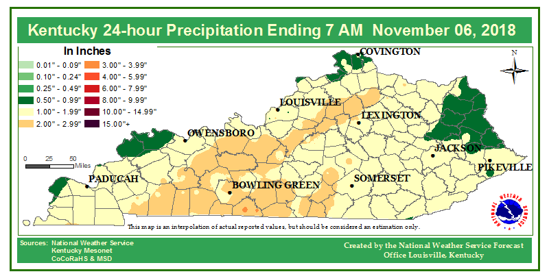 |
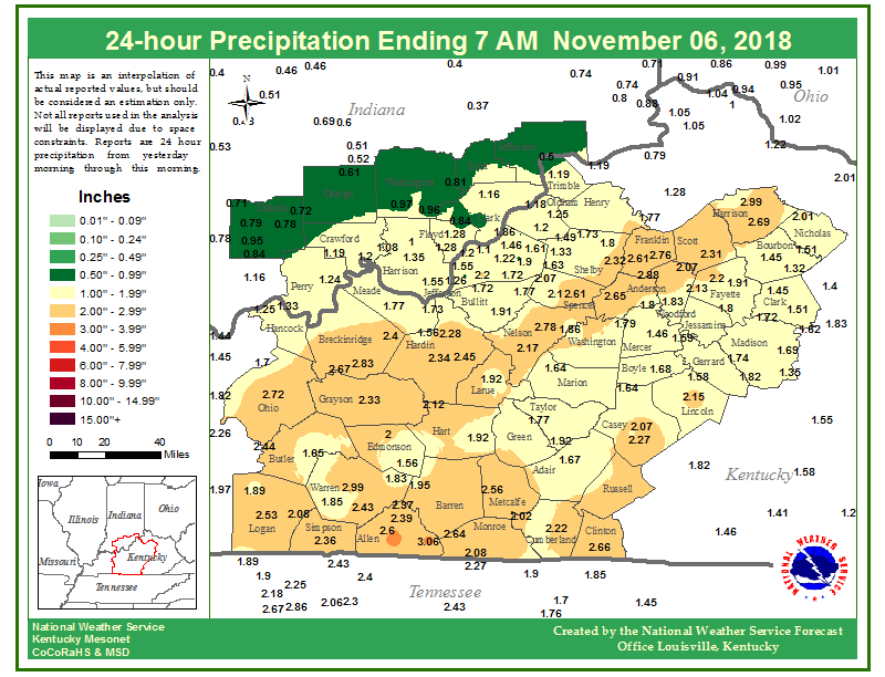
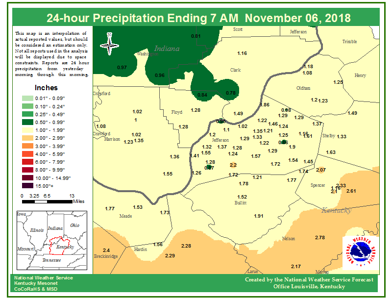
| Figure 1: 24-hour rainfall totals across southern Indiana and central Kentucky, ending at approximately 7 AM EST Tuesday. | Figure 2: Same, but for a zoomed in look at the Louisville Metro area. | Figure 3: Same, but for the entire state of Kentucky. |
Environment
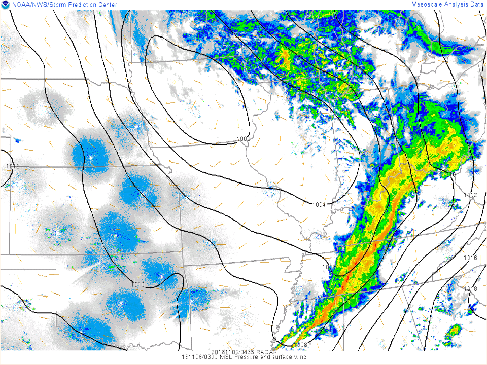
Some images showing what the environment setup was like for the line of severe storms that went through central Kentucky Monday night.
 |
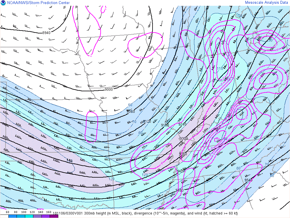 |
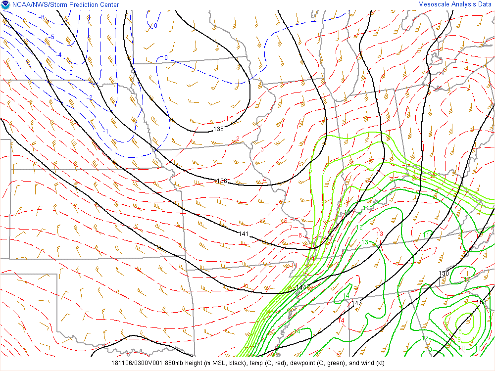 |
| Figure 1: Radar image and pressure field contoured. Line of storms formed ahead of front. | Figure 2: Upper level wind field, showing a jet streak (120-130 knots) moving over mid MS River. Contours are areas where atmosphere allowed for good "outflow" of thunderstorm tops. | Figure 3: Lower-level flow field, around 3000 feet above ground, showing 60-70 knot winds blowing across central Kentucky as well as lots of moisture (green contours) and warmth (red dashed lines). |
 |
 |
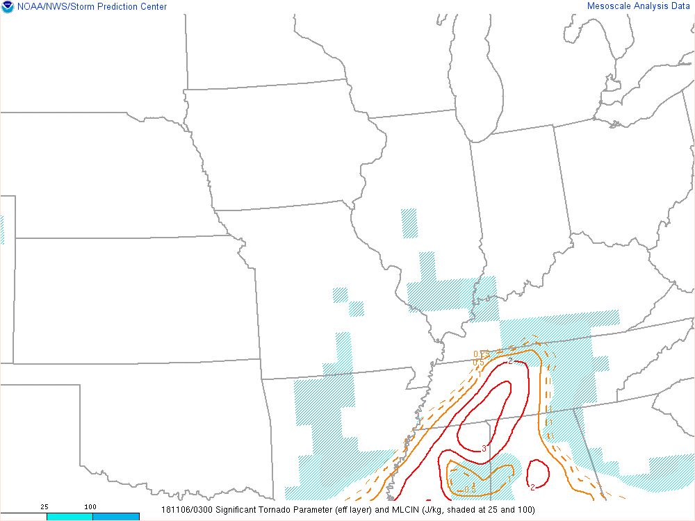 |
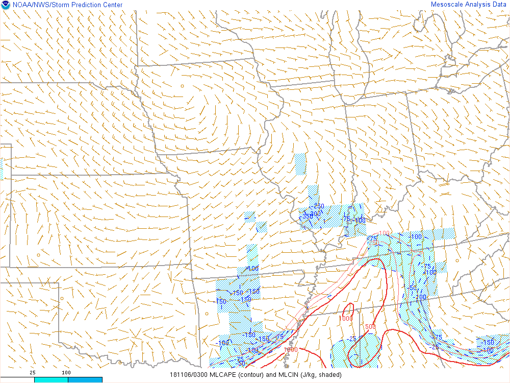
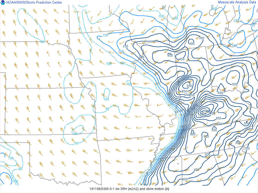
| Figure 4: A measure of available instability, just nosing into southern KY. These fall severe events typically have just a little bit of instability to work with to allow for strong rotation aloft to get down to the surface in a few places. | Figure 5: A measure of just how strong the rotation was from the surface to 1 kilometer above ground. Thanks to the limited instability, a lot of this shear was not realized in more tornadoes! | Figure 6: The Significant Tornado Parameter (STP), showing that more violent tornadoes (EF2 or greater) were not likely over our region. |
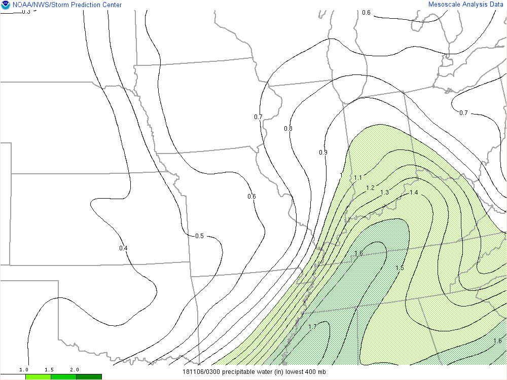 |
| Figure 7: The precipitable water, a measure of how much moisture was available for storms to work with. This map shows values pretty high for this time of year. |
 |
Media use of NWS Web News Stories is encouraged! Please acknowledge the NWS as the source of any news information accessed from this site. |
|


 Weather Story
 Weather Map
 Local Radar