.png)
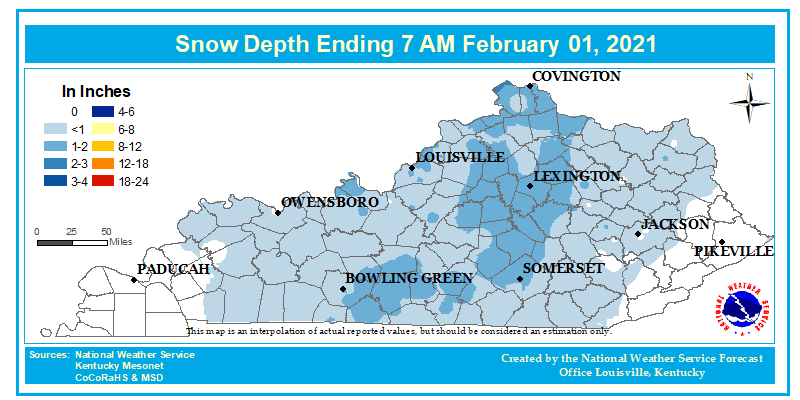
...SNOWFALL REPORTS...

Location                     Amount    Time/Date       Lat/Lon

...Indiana...

...Crawford County...
1 NNE Carefree               1.4 in    0620 AM 02/01   38.26N/86.35W
Pilot Knob                   1.0 in    0800 AM 02/01   38.28N/86.35W

...Dubois County...
1 S Huntingburg              1.7 in    0600 AM 02/01   38.29N/86.96W
Saint Anthony                1.3 in    0710 AM 02/01   38.32N/86.83W
Ferdinand                    1.0 in    0750 AM 02/01   38.23N/86.86W

...Floyd County...
2 E Byrneville               1.8 in    0700 AM 02/01   38.34N/86.01W
3 ESE Scottsville            1.2 in    0800 AM 02/01   38.38N/85.87W
1 W Cementville              1.0 in    0700 AM 02/01   38.35N/85.77W
2 W Cementville              0.8 in    0810 AM 02/01   38.36N/85.81W

...Harrison County...
2 NNW White Cloud            1.6 in    0700 AM 02/01   38.26N/86.25W
1 W New Salisbury            1.0 in    0800 AM 02/01   38.32N/86.12W

...Perry County...
Tell City                    0.7 in    0800 AM 02/01   37.95N/86.76W

...Washington County...
2 N Bunker Hill              2.0 in    0700 AM 02/01   38.60N/85.89W
1 ENE Mckinley               1.5 in    0859 AM 02/01   38.76N/86.18W

...Kentucky...

...Allen County...
6 N Scottsville              1.1 in    0700 AM 02/01   36.83N/86.18W

...Anderson County...
3 NNW Salvisa                1.5 in    0700 AM 02/01   37.96N/84.89W

...Breckinridge County...
McDaniels                    0.5 in    0900 AM 02/01   37.61N/86.42W

...Butler County...
1 SSW Aberdeen               0.8 in    0900 AM 02/01   37.24N/86.69W

...Casey County...
1 SE Liberty                 1.0 in    0700 AM 02/01   37.30N/84.92W

...Clark County...
1 SSW Winchester             1.0 in    0855 AM 02/01   37.99N/84.19W

...Fayette County...
2 W Lexington                1.5 in    0700 AM 02/01   38.05N/84.54W
2 SSW Lexington              1.5 in    0700 AM 02/01   38.02N/84.52W
5 ESE Lexington              1.3 in    0900 AM 02/01   38.03N/84.42W

...Franklin County...
1 WNW Forks of Elkhorn       1.5 in    0715 AM 02/01   38.22N/84.82W
2 NE Frankfort               1.0 in    0800 AM 02/01   38.21N/84.85W

...Garrard County...
Lancaster                    1.0 in    0730 AM 02/01   37.62N/84.58W

...Henry County...
4 NE New Castle              1.0 in    1000 AM 02/01   38.48N/85.11W

...Jessamine County...
1 ESE Nicholasville          1.9 in    0700 AM 02/01   37.87N/84.56W
3 N Keene                    1.0 in    0700 AM 02/01   37.98N/84.64W

...Mercer County...
2 ESE Mcafee                 1.3 in    0930 AM 02/01   37.84N/84.81W
2 WNW Duncan                 1.1 in    0700 AM 02/01   37.86N/85.01W

...Monroe County...
4 NNW Flippin                1.0 in    0413 AM 02/01   36.76N/85.90W

...Nelson County...
1 W Balltown                 1.0 in    0800 AM 02/01   37.73N/85.52W

...Oldham County...
1 NNE Prospect               1.2 in    0745 AM 02/01   38.36N/85.60W
Westport                     1.1 in    0715 AM 02/01   38.49N/85.47W
1 SSE Goshen                 1.0 in    0845 AM 02/01   38.40N/85.58W

...Taylor County...
Campbellsville               0.7 in    1000 AM 02/01   37.35N/85.35W

...Warren County...
Smiths Grove                 1.0 in    0700 AM 02/01   37.05N/86.20W

...Woodford County...
5 N Nonesuch                 1.4 in    0700 AM 02/01   37.97N/84.76W

Observations are collected from a variety of sources with varying
equipment and exposures. We thank all volunteer weather observers
for their dedication. Not all data listed are considered official.


 Weather Story
 Weather Map
 Local Radar