Louisville, KY
Weather Forecast Office
A strengthening low pressure system moved through the region yesterday, and very strong winds were observed through the morning and afternoon hours. Many locations saw peak gusts ranging between 40 and 55 MPH, with some minor damage and sporadic power outages also noted through the day.
-MaxWindAnalysisPublic.png)
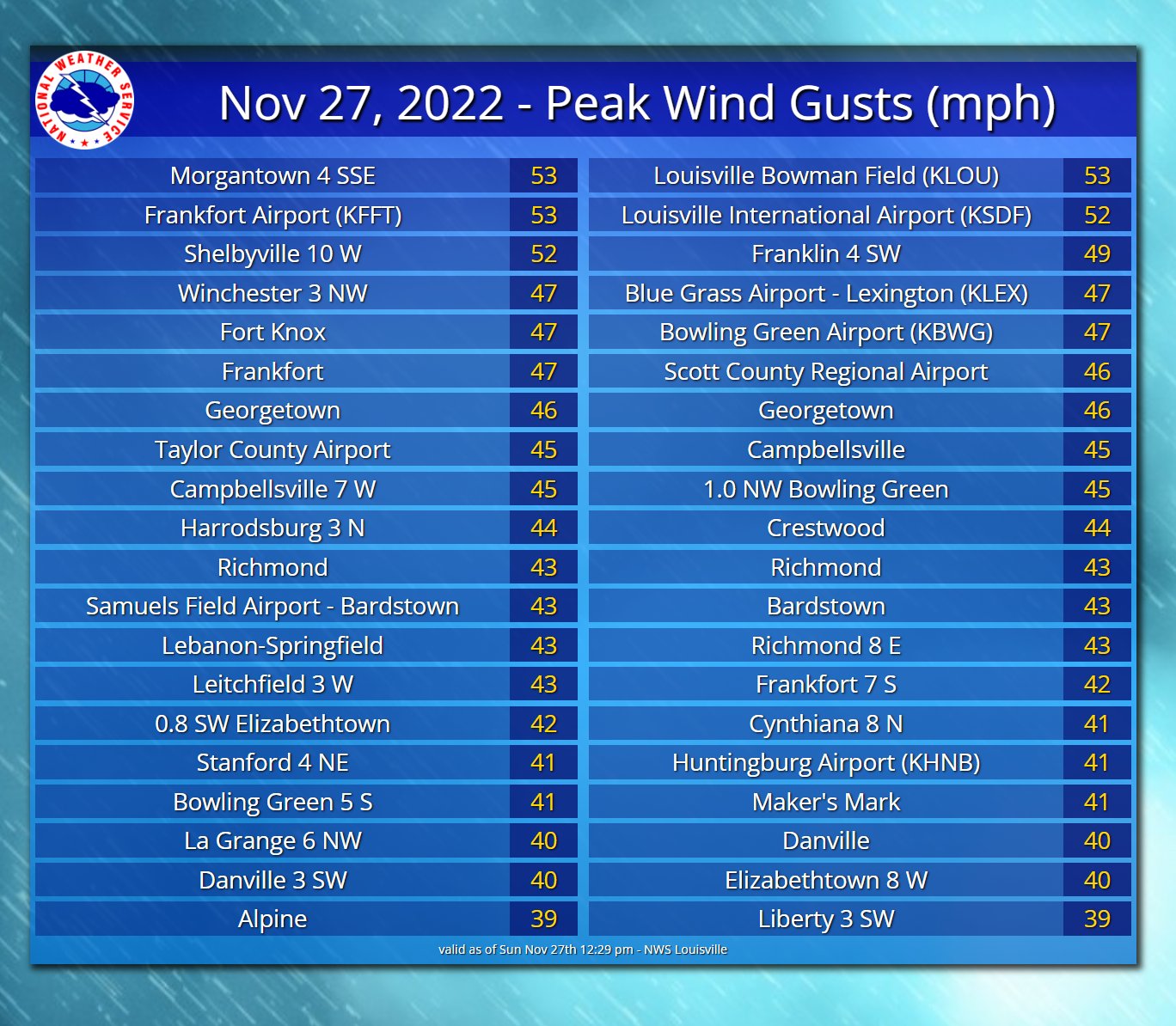
PRELIMINARY LOCAL STORM REPORT...SUMMARY
NATIONAL WEATHER SERVICE LOUISVILLE KY
723 PM EST SUN NOV 27 2022

..TIME...   ...EVENT...      ...CITY LOCATION...     ...LAT.LON...
..DATE...   ....MAG....      ..COUNTY LOCATION..ST.. ...SOURCE....
            ..REMARKS..

0700 AM     NON-TSTM WND DMG 2 SE CAMPBELLSVILLE     37.33N 85.32W
11/27/2022                   TAYLOR             KY   EMERGENCY MNGR

            TAYLOR COUNTY EMERGENCY MANAGER SHARED
            PICTURES OF A TREE DOWN ON A HOUSE AND
            VEHICLE. SAID IT OCCURRED SHORTLY BEFORE
            SUNRISE.

0810 AM     TSTM WND GST     4 WNW FINCHVILLE        38.16N 85.38W
11/27/2022  M52 MPH          SHELBY             KY   MESONET

            KENTUCKY MESONET SITE FCHV.

1036 AM     NON-TSTM WND GST 4 NW OKOLONA            38.18N 85.74W
11/27/2022  M52 MPH          JEFFERSON          KY   ASOS

            MEASURED AT KSDF ASOS.

1046 AM     NON-TSTM WND GST 2 SW SAINT MATTHEWS     38.23N 85.66W
11/27/2022  M53 MPH          JEFFERSON          KY   ASOS

            MEASURED AT KLOU ASOS.

1009 AM     NON-TSTM WND GST 2 WSW FRANKFORT         38.18N 84.91W
11/27/2022  M53 MPH          FRANKLIN           KY   ASOS

            MEASURED AT KFFT ASOS.

0328 PM     NON-TSTM WND GST 6 W LEXINGTON           38.04N 84.60W
11/27/2022  M50 MPH          FAYETTE            KY   ASOS

            MEASURED AT KLEX ASOS.

0605 AM     TSTM WND GST     2 ENE WOODBURY          37.20N 86.60W
11/27/2022  M53 MPH          BUTLER             KY   MESONET


0804 AM     NON-TSTM WND DMG 1 E MORGANTOWN          37.22N 86.68W
11/27/2022                   BUTLER             KY   PUBLIC
Current Hazards
Hazardous Weather Outlook
Storm Prediction Center
Submit a Storm Report
Advisory/Warning Criteria
Radar
Fort Knox
Evansville
Fort Campbell
Nashville
Jackson
Wilmington
Latest Forecasts
El Nino and La Nina
Climate Prediction
Central U.S. Weather Stories
1-Stop Winter Forecast
Aviation
Spot Request
Air Quality
Fire Weather
Recreation Forecasts
1-Stop Drought
Event Ready
1-Stop Severe Forecast
Past Weather
Climate Graphs
1-Stop Climate
CoCoRaHS
Local Climate Pages
Tornado History
Past Derby/Oaks/Thunder Weather
Football Weather
Local Information
About the NWS
Forecast Discussion
Items of Interest
Spotter Training
Regional Weather Map
Decision Support Page
Text Products
Science and Technology
Outreach
LMK Warning Area
About Our Office
Station History
Hazardous Weather Outlook
Local Climate Page
Tornado Machine Plans
Weather Enterprise Resources
US Dept of Commerce
National Oceanic and Atmospheric Administration
National Weather Service
Louisville, KY
6201 Theiler Lane
Louisville, KY 40229-1476
502-969-8842
Comments? Questions? Please Contact Us.


 Weather Story
 Weather Map
 Local Radar